Fall so far has been much cooler and snowier than normal in the Northwest.
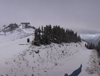
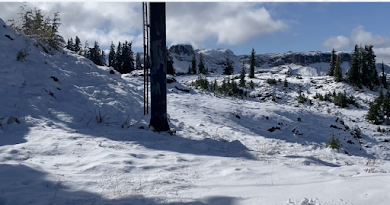
To "warm-up" this discussion, take a look at the snow coverage at Crystal Mountain and at Mt. Baker Ski resort--enough to motivate a search for the hot chocolate mix.
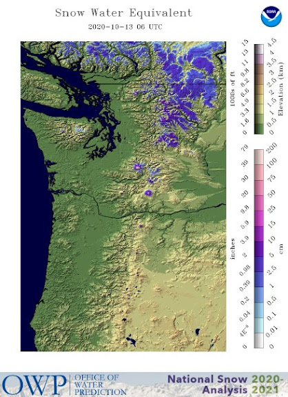
A more quantitative view is provided by the NOAA snowpack analysis today (actually the snow-water-equivalent--the amount of water in the snowpack), compared against the last year (see below). A lot more snow this year!

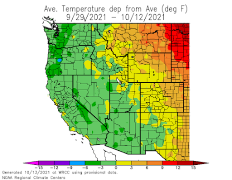
The temperature departure from normal over the past two weeks is chilling: western Washington and Oregon have been much cooler than normal (by 3-6F). So have much of the West.
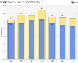
And plotting the temperature at Sea-Tac versus the normal highs and lows over the past two weeks is startling: Only ONE day had a high temperature reaching the normal values and MANY days had low temps plunging well below the normal lows:


Nothing depressing about that forecast. Bring it on.
ReplyDeleteAfter this past summer, I have no complaints.
ReplyDeleteReady for the snow!!!
ReplyDeleteThe National Weather Service climate 8 to 14 Day Outlooks says it will be warmer than normal.
ReplyDeleteCliff- How do we define 'normal' range?
ReplyDeleteIs normal considered the conditions measured over past 30 years, or is it based on longer term data?
Thank you.
It just needs to be a couple of degrees colder than last year. There were multiple days where we had rain at the base of Stevens pass and snow at the top. If it can be snow top to bottom, that is preferable!
ReplyDeleteI'm sure the pattern will flip later this fall or winter there's always two sides of a coin so I'm going to enjoy the cool weather now while it last.
ReplyDeleteBring on sweaters and snow!
ReplyDeleteProf. Mass, I hope you will do some posts about average temperatures and aggregate precipitation for the year. We all remember it was HOT and we remember it was DRY, but we aren't wired to figure out that on average it was a hot/cold/wet/dry year. Thanks!
ReplyDeleteA few inches of early snow does not a snowpack make.
ReplyDeleteThank you, Captain Obvious.
DeleteWhile the loss of tomatoes is a sad and all too common phenomena in the PNW, zucchini is an invasive weed
ReplyDeleteWhen do you think we might start to get snow at around sea level this year? Well what ever elevation most cities here in the Puget Sound are at, which seems pretty close to sea level.
ReplyDeleteAlso unrelated question. Is it just confirmation bias or is it the case that most wind storms occur at night or at least around nighttime? Likely I'm just remembering them more as they tend to keep me up at night with the large trees right outside of my bedroom. LOL But it sure does feel like more are at night than during the day. If that's the case where wind storms are more often at night, why is it that way?