It will not be a little ironic that a year that brought record-breaking high temperatures in June, also brings extreme cold in December.
But life is full of contradictions and ironies.....

The latest model runs suggest that immediately after Christmas temperatures will plummet to levels not seen in our region for perhaps decades.
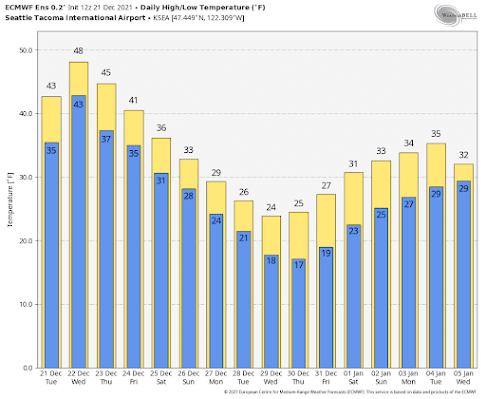
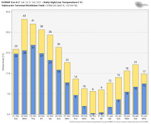
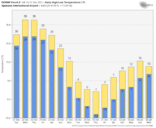
Let's begin with the European Center ensemble forecasts....averages of many runs from the best global prediction center in the world.
For Seattle-Tacoma Airport, highs only reaching the mid-20s, and lows in the teens--something we haven't seen in several years. A totally hard freeze.
And do I dare show you the forecasts for Spokane? Where one day never gets above zero?
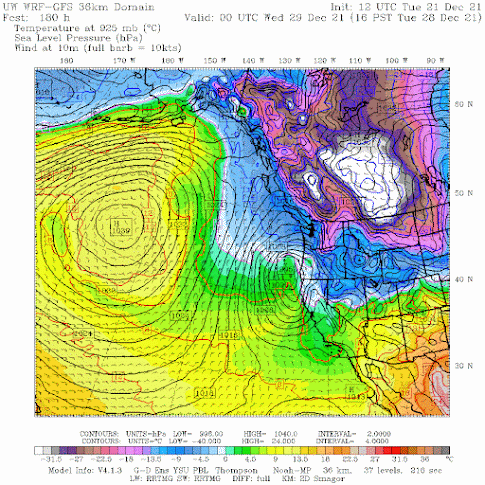
Extreme high pressure over the northeast Pacific.
Extreme cold (white and purple colors) over the interior of BC and just east of the Rockies.
And frigid temperatures (blue colors) over the Northwest.
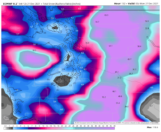
Maybe not on the ground Christmas morning. But the chances for snow AFTER Christmas looks favorable. The total snowfall (not accumulation) through Sunday at 4 PM is roughly 2-4 inches around Puget Sound. More on that in future blogs, particularly since there is still considerable uncertainty in the snow forecast.
But you can bank on cold air coming...so get ready.
Outdoor faucets should have hoses removed. Pets should be moved inside. And local agencies have to get homeless folks off the streets...this period will be cold enough to be life-threatening.


Any record lows in this forecast?
ReplyDeleteIn January 1991, an arctic outflow hit where we live on Bowen Island, Howe Sound, right around the corner from Vancouver. Temps were -16 C, ie pretty much 0 F. Wind was northerly 77 knots, ie 88 MPH. Good sized Fir trees simply cracked in half. So extreme weather can hit, but not very often...
ReplyDeleteI remember this..i rode the ferry to Seattle and the waves were making salt ice cycles on the pickle forks. We were without power and vouldnt leave the house because Trenton Ave in Bremerton has a 3 inch deep sheet of ice from house water pipes bursting.. we took matresses and blankets and made a room inside a room and 6 people sat in there without power or heat for days!!.
DeleteCliff, legit curious. Your previous post said Christmas snow was unlikely, but at the time, models were painting this picture even back then. What drove you to go with averages during that proclamation?
ReplyDeleteDon't understand your question.
DeleteMaybe I can jump in here.
DeleteYour blog of Dec 18th said that snow at sea level on Christmas day was "improbable for now'. Even on the 18th, the long range models were forecasting well below normal temps and mixed precip/snow for the 24th onwards in Bellingham, at least.
I'm guessing the question was related to this blog post stating snow was improbable when the models were already indicating the potential.
For what it's worth, I used to be a weatherman in the UK so understand what a thankless task it is predicting the weather!
I had the same question.
DeleteAre Fraser outflow events an indication for Hood Canal snow events when the eventual warm moisture overruns the cold air, is ther a correlation on that ?
ReplyDeleteI was wondering that, too.
ReplyDeleteI've got a Mexican fan palm that's been in ground for ten years. Looks like it will be the end of the line assuming this pans out. Was a helluva run.
ReplyDeleteWrap it up in a blanket then a tarp over it, making sure the surrounding surface soil is protected as well.
DeleteMy fuscias and pansies are still blooming. I've lived in the area since the 70's and this is the latest in the year I can remember. (This is a glass-half-full thought for those of you fixated on bemoaning extreme weather events.)
ReplyDeleteWhat is the historical record since 1990 for day highs below 32 in Seattle. I think we've had a few years without even a high below freezing. Six or seven days in a row should be a record for the last 30 years or so.
ReplyDeleteYour predicted weather event was a bust. It's not easy to predict snow in Seattle.
ReplyDelete