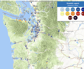
Update: Here are the latest storm totals from the National Weather Service. Heavy snow near Port Angeles (10-15 inches) and 1.5 to 5 inches around Puget Sound.
Here is an expanded version around Seattle. Perhaps an average around 3-3.5 inches.
_____________________
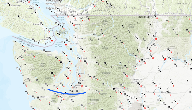
As predicted, the cold air pushed into western Washington, with the arctic front on the leading edge, with highly variable snow depths reported at 7 AM this morning (see Cocorahs snow map below).
Cold air entered Bellingham yesterday leading to lots of snow (4-15 inches reported), and as the cold air pushed southwestward later yesterday, the northern Olympic Peninsula area areas (e.g., Sequim to Port Angeles) got hit hard, with up to around a foot of snow.
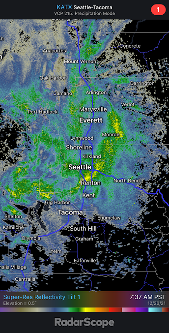
Over Puget Sound, most of the snow action was with the arctic front this morning, with 3-5 inches being reported. The radar image at 7:37 AM this morning clearly showed the intense arctic front snowband (yellow colors) pushing southward. The high-resolution models got this feature essentially correct.
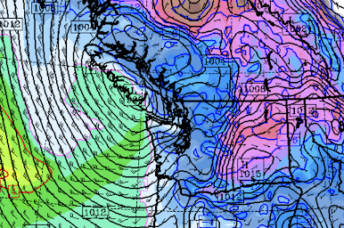
The current observations show tremendous temperature and wind variability across the region (see surface map at 10 AM, click on I'm age to expand). The leading edge of the arctic front is now (11 AM) around Olympia (blue line), with northerly flow behind it and southerly flow in front of it. The convergence of air into this feature causes upward motion and precipitation.
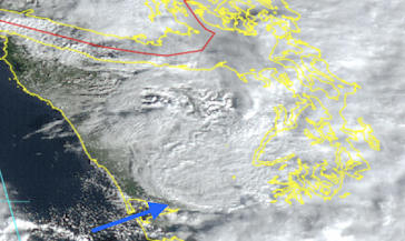
In a stunning visible satellite image at 11 AM, you can see the front edge of the arctic front approach Hoquim (see below).
At Bellingham, the temperature this morning was 10F, with winds gusting to 56 mph. Severe windchill for this region: equivalent to -18F! Temperatures below 10F are also moving through Omak and the Okanagan Valley into eastern Washington.
There will be some light snow today, producing perhaps another inch and then it will clear out tonight, allowing cooling (infrared radiation to space). Temperatures should drop into the upper teens from Puget Sound northward, with lower temperatures over Northwest Washington. Even colder over eastern Washington. This is the cold that has been advertised for the last several days.
Seattle DOT and Washington DOT need to remove as much snow as they can from the roadways. Any snow will turn to ice during the next 24h, as heat from the roadways initially creates a melted layer near the surface that will subsequently freeze. And chemical treatment as well.
Icy roadways are the greatest weather killer of Washingtonians.....WAY more than heat waves, something you may not hear about in the media. The truth is that cold weather is a far greater killer in our region than heat waves.
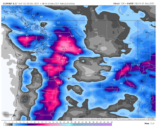
The Potential Thursday Storm
With cold air entrained over the region, we will be very vulnerable to potential snow. On Thursday morning, a low center and front will be approaching our region, with cold air in place (blue colors in figure below). There is still some uncertainty with this feature, so I need to be careful in talking about it.
The current UW model run puts down substantial snow, but there is a large snow gradient across the Sound (the result of Olympic rainshadowing and temperatures on the edge). Around 2 inches over Seattle.
The European Center model is going for more, but has the same general idea.
Anyway, we will keep our eyes on this.
_______________________________________________
PS: there are a lot of amateur enthusiasts that are looking at the raw model output.
Please keep in mind the difference between snowfall and snow depth. When temperatures are marginal (such as on Dec. 25th), the snowfall tends to be MUCH higher than the resulting snow depth. After the temperatures cool off (like today after midnight in Puget Sound, when temperatures are colder and snow ratios are larger (snow depth to depth of liquid water), snowfall and additions to snow depth are much closer.


Thank you so much for keeping us informed.
ReplyDeleteIn looking at the forecast ten days out, it seems the highs will not get above the 30s and the lows will stay at freezing or below, with snow predicted each day (after the extreme cold goes, that is, i.e., from Thursday on).
We have about 6" in Lynnwood. I suspect a lot more accumulation, and while I'm grateful to have shelter and heat, my heart is heavy because of those who are out in this.
Stay safe and warm!
I just drove I5 from Tacoma to Seattle. It's a mess. Only oneane without snow, I saw 3 accidents including one involving police cruisers. The highway is covered in snow and slush. I saw several trucks pulling over to chain up.
ReplyDeleteApprox 25F and 4 inches of snow in Woodinville, and it's still coming down.
ReplyDeleteI learn something valuable EVERY time I read your blog.
ReplyDeleteThank you so much for everything you do!!!!
i think most people understand that the totall snowfall is usually a bit more than snow depth, or a lot more. but at the same time, most of us are looking out our windows at a LOT more accumulation than anyone said would happen. Im all for it. Love it, and i squeal in pain every time a plow drives by. Im praying for round two on thursday
ReplyDeleteAgreed. However, I don't think most people even think about total snowfall versus snow depth.
Delete"The truth is that cold weather is a far greater killer in our region than heat waves."
ReplyDeleteThis axiom also holds true for the rest of the country, something the AGW crowd conveniently ignores.
Will the agw crowd now claims any kind of whether that's even slightly abnormal is ze "climate change".
DeleteWhile this may be true in the immediate (loss of heat and water leading to people freezing in their homes; vehicular accidents; etc.), there can still be significant loss of life in prolonged heat waves (see the Europe heat wave of 2003 as an example), especially since they are more likely to be longer duration events than most cold spells.
DeleteAdditionally, heat waves lead to other long-term society-altering impacts. An extended heat wave can create or exacerbate drought conditions that can affect food production for regional populations, thereby leading to increased emigration and civil unrest. Most extreme cold events do not cause such societal upheaval (not to say that ALL heat waves do this, but it is a common if not frequent outcome). Even though our local heat waves may not lead to mass starvation and societal upheaval, there are still tremendous economical and societal impacts when farms and farm workers are forced to deal with those situations.
So, I don't necessarily think your statement is false relating to our region, I do feel it's important to not pretend that extreme heat is not a legitimate concern, locally or globally.
Heat is certainly a concern....don't get me wrong. But there is a deep literature....and good data....showing that in the U.S. and worldwide that cold kills and injures far more people than heat. That will change over time as the earth warms...more heat waves and less cold waves. Strangely enough, global warming could well result in less death from heat extremes. Clearly, we need to protect our populations from both. Ensuring all people have places to go with cold hits...and sufficient heating. Improved road maintenance during snowy periods. And expanding use of AC around the world and building our cities so they are cooler.
DeleteI am curious, is the resulting snow accumulation in Bellingham higher than originally forecast because the temperatures on Christmas Day were much colder than the models predicted?
ReplyDeleteI’m just going to assume that the snow on Thursday will be more than they are predicting just based on how off the predictions were today
ReplyDeleteRE: "...surface map at 10 AM." I can read the wind indicators; what are the black and red numeric values?
ReplyDeleteBlack is surface temp at that reporting station. Red represents the max wind gust of the last hour.
DeleteThank you
Delete7 1/2" on the ground on the hills North of Lynnwood. Still snowing. Roads are already iced up from car engine heat at the intersections. Extremely hazardous driving conditions already.
ReplyDeleteWe got next to nothing here in Vancouver
ReplyDeleteBC or WA?
DeleteI'd say 5-6 inches in north Shoreline. The NWS called it "bands" of varying snowfall. That's a useful description.
ReplyDeleteMount Vernon, toward Big Rock at highway 9, snow was about 10 inches, but has very high moisture content. Without a neighbor's snow-blower, it was too back-breaking to clear this heavy snow.
ReplyDeleteCurrently, at 11:27 PM on Sunday, December 26, it is 20° F in Seattle and it is 37° F in Fairbanks.
ReplyDeleteWest Olympia ended up with 7-8" by the end of the afternoon. Forecasts only off by 5" or so!
ReplyDeleteI cringe when I hear network news people say " only a half inch or so.."
DeleteIt usually means we will get dumped on.
16" on the picnic table in Port Angeles, 600' elevation.
ReplyDeleteCliff you state:
ReplyDelete"Icy roadways are the greatest weather killer of Washingtonians.....WAY more than heat waves...."
Do you have a source for that? The links below indicate that might not be true - and likely won't be for this year at least?
Northwest heat wave: Death toll reaches at least 112
https://apnews.com/article/heat-waves-3295ea60f9ba1968d7f2da22a6d3ff2d
https://icyroadsafety.com/fatalitystats.shtml
The icy road deaths and injuries were secured from the Washington State Patrol data base. On average, icy roads are a bigger killer than heat waves. And keep in mind that YOUNGER people with more years to live are killed by cold waves, while heat waves generally kill the elderly. If we calculated the number of human years of life are lost, it would not be close. Icy roads are a bigger danger.
DeleteRight, younger drivers tend to be less experienced and don't know how to drive in the snow. Especially here in Western WA, one does not get a lot of practice. And as you say, it is especially challenging here because the relatively warm ground melts the first snowfall, which later refreezes.
DeleteSure, Cliff - But your stating that icy roadways kill WAY more than heat waves had no reference to age of those being killed.
DeleteAnd the ageist argument was also used in the early stages of COVID by those who were minimizing the potential impacts since it was mainly killing elders.
The age is an important issue (NOT AGEISM). But forget age. On average Far more people die each year from cold (including accidents) than heat. That is absolutely clear.
DeleteThe main challenge with predicting snow around here is whether or not any falls at all. Once it does the amount seems to be anyone's guess and highly variable.
ReplyDelete12F this morning at the west Rattlesnake Mountain trailhead. I90 was good up to 40mph if you slow down for the rough spots (Bellevue is particularly awful, and the highway was still snowed over midday). People were fishtailing in the slush.
ReplyDeletePlease remember that slush at 20F is not a great driving surface!
8 inches in maple valley. Love it. Looks like more on the way late wednsday thursday
ReplyDelete