During the past year, precipitation contrasts across the Cascades were greater than normal.
The normally wet western side was wetter than normal.
The normally dry area east of the Cascade crest was drier than normal.
But WHY?
By the time you finish this blog, you will know!
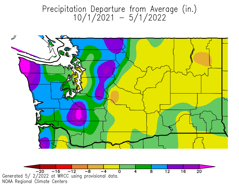
Let's start by showing you difference from normal of the precipitation over the state from October 1 through the end of March (see below).
Hugely wetter than normal over the western slopes of the Cascades and over the northwest side of the Olympics (purple colors). But eastern Washington was 0 to 4 inches below normal (yellow colors).
Since eastern Washington is such a dry place, if you really want to be impressed, take a look at the percentage of precipitation for the same period. Some places on the western side were over 130% of normal, but in eastern Washington, along the eastern slopes of the Cascades and downstream of the Okanagan Highlands, some locations were 50-70% of normal.
The deficit in inches was small, but if one is talking about an area that is essentially desert, a small drop in inches can be a large percentage.
.png)
So why did we get this precipitation pattern, which is clearly tied closely with the terrain?
The answer is La Nina and the large-scale atmospheric pattern it created. And remember, La Ninas are associated with colder than normal sea surface temperatures in the central and eastern tropical Pacific.
Take a look at the pressures or heights at 850 hPa (about 5000 ft)--see below.
This plot is showing the difference from normal. Over the Pacific, pressure were higher than normal at this level. Over western Canada, the pressures were lower than normal.
The result of these two pressure features was an area of large pressure change over the northwest...and large pressure changes result in winds. And since winds at this level (around 5000 ft) tend to parallel the pressure lines, this situation produced an enhanced northwesterly wind (from the northwest, see the arrow)
.png)
But northwesterly winds also produce more downward flow on the eastern side of the Cascades, resulting in more downward flow that decreases precipitation.


So what does this have to do with La Nina? Because La Nina situations tend to produce exactly this pressure pattern.
Want proof? Here is the plot of differences from normal pressure at around 18,000 ft for La Nina years from a NOAA website. Mama Mia! It looks just like the figure above.
So colder than normal waters over the central/eastern tropical Pacific resulted in a strong La Nina this fall and winter, that produced an offshore high and an inland low that led to stronger than normal northwesterly winds, that produced enhanced upslope flow on the western side of the Cascades and downslope flow to the east, which in turn modulated precipitation.
Kind of reminds you of something:


Sounds like supporting evidence for the drought conditions in Eastern Washington you wrote about on April 24, 2022.
ReplyDeleteTom...I thought someone would ask that! The key is that April was so wet in eastern WA that most of the deficit is now gone, with the substantial moisture wetting down the upper soil layers. Plus the fact it did precipitate in the mountains provides bountiful snow and streamflow...cliff
DeleteThe two maps showing the deficit run to May 1 and therefore include April's precipitation.
DeleteJason...look at far SW Washington..that is where the dryland farmers are concentrated...now above normal. The dry area...is improved...but is meaningless. Agriculture is virtually all irrigated there. So if you actually measured the soil moisture it would be wet! But the water comes from irrigation.. And there is plenty of water available...cliff
DeleteWhen will La Nina ever end this year?
ReplyDeleteAfter experiencing the statewide disasterous wildfires over two years ago in OR, when people here start complaining about the colder and wetter spring, I just shake my head at them.
ReplyDeleteI just shake my head at people when they think the only possible outcomes are extreme events. Wanting a warmer/normal spring does not mean that there will be disastrous wildfires. You realize there are possibilities in between, right?
DeleteHi Cliff, do you see the atmosphere changing configuration into a dry phase any time soon? I'm perpetually amazed at the efficiency of our rivers to transport liquid back to the ocean this year.
ReplyDeleteYuck! if we have to have rain why can't we have that warmish pineapple express rain? I hope this isn't going to be 1993 all over again.
ReplyDelete