May 2022 will go down as one of the wettest and coolest in Northwest history, setting the stage for a delay in the regional wildfire season.
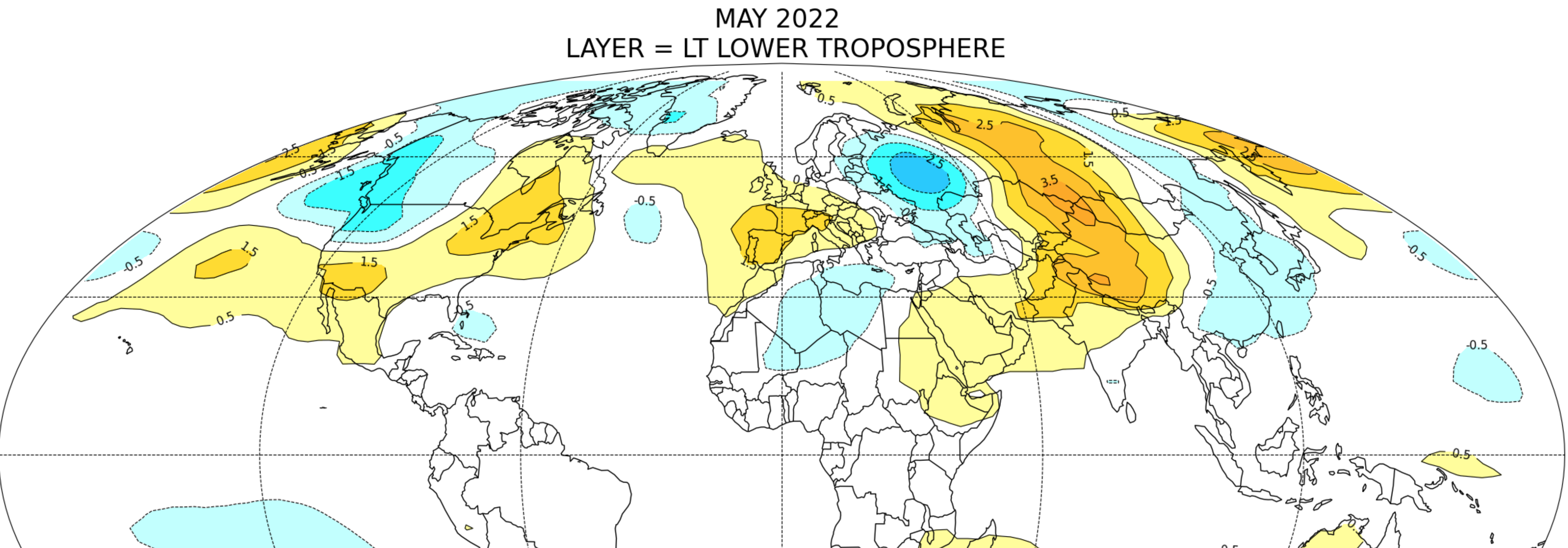
To provide some perspective, here are the lower atmosphere temperature differences from normal (°C) for the month, courtesy of Dr. John Christy of the University of Alabama in Huntsville. A cold bullseye is apparent over the Pacific Northwest (medium blue colors, more than 1.5C below normal). Only one place is colder: eastern Russian (I could make a comment here, but won't).
The eastern U.S. was warmer than normal in May. The yin and yang of weather.
The snowpack over our region is amazingly deep (see below). For example, the snowpack on the southeastern side of the WA Cascades is EIGHTEEN HUNDRED FIFTY percent of normal. Yes, 18 times normal. The snowpack east of central Puget Sound is 319% of normal. Just crazy.
And if that does not impress you, Seattle had its wettest May since 1948 (see below). You will notice there is little long-term trend in Seattle precipitation.
The entire region was frigid during the past month, with temperatures over much of the Northwest averaging 4-6F below normal for the month. The cold extends eastward to Idaho, Montana, and Wyoming....and beyond.
Because of a persistent trough of low pressure than has been hanging around over the region.
To illustrate, below is a map of the difference from normal (the anomaly) of heights at the 500 hPa pressure level (you can think of it as the difference from normal of the pressures at 18, 000 ft) for the past 30 days Blue and purple indicate much lower than normal pressures/heights-- called a trough.
A very large, strong trough is over our region--and that produces cool/moist conditions. In contrast, there is ridging...higher than normal heights and pressures-- over the eastern U.S. where temperatures are above normal. There is a very wavelike pattern of alternating low and high pressure. Not an unusual pattern.
Now the depressing part.
The latest model runs suggest June is going to continue the cool/wet regime. Sorry.
For example, the latest UW model forecast for the accumulated precipitation over the next week shows bountiful rain over the region, with many of the mountain areas getting more than 2 inches. That is a lot for June. Even northern CA gets a piece of the wet action.
And the temperatures are predicted to be substantially cooler than normal over the next week (see European Center ensemble forecast for temperature difference from normal below). The entire Northwest will be cooler than typical (blue colors).
It appears that the old adage about Northwest weather will be true this year: Northwest summers start on July 12th. Only a month and a half away!

.png)
.png)

.gif)


Thanks Cliff, what the temperature outlook for july and august is it looking cool too?
ReplyDeleteI'm a long-time fan of yours, in part because of a responsible, science-based approach to weather and data interpretation.
ReplyDeleteThat said, I was dismayed to see you irresponsibly trumpet, "EIGHTEEN HUNDRED FIFTY percent of normal. Yes, 18 times normal."
But 18 times of what? Did you mention that?
A saner Dr Mass would refrain from such hysteria and simply state the current snowpack persists east of the Cascade crest when in 'normal' years it would have mostly melted by now.
The more responsible metric to cite would be to say, "The current snowpack is approximately 3 weeks behind 'normal' melt-out."
But that wouldn't be nearly as dramatic... or are you angling for a job at the Seattle Times?
Mark...sorry...I was having some fun...although it is totally true. And don't worry, the LAST thing I would want is a job at the Seattle Times. One gets such large numbers at the tail of the season when the snowpack is normally declining...cliff
DeleteAnd today it shows 10,600% of normal. It starts to get pretty amusing sometimes when dealing with very small numbers for normal snowpack.
DeleteIn a high snow year, in any given location, as the snow disappears, the percent of normal goes to infinity as the denominator goes to zero!
DeleteFine by me.
ReplyDeleteHow bad was May ?...I would say "How good was May !"
ReplyDeleteI agree 100%. May weather was great, and if June looks more like May that would be awesome!
DeleteMaybe we'll escape June without a 107F day like we had last year. Thank you.
ReplyDeleteNothing really wrong with this past month. There were plenty of nice days. Skipping the exceptionally hot and dry this year will be ideal, considering the cost of everything. Not running AC or using excessive water is a plus.
ReplyDeleteSorry, wouldn't the only place colder be western Russia?
ReplyDeleteCliff didn't want to say it, but I will: Putin is getting (a small portion of) what he deserves.
DeleteHe's comparing to the average for the given location... That's what that map was- not actual temperature.
DeleteToo bad more of the American/Canadian west won't get more rain as well, but I will take what we can get.
ReplyDeleteMaybe this cool trend will discourage those "murder hornets" from moving southward!!
ReplyDeleteEveryone knows I'm old when I reminisce about the springs we used to have when it would be 63-75, lots of sun with some showers here and there. It was so nice! I guess things change though.
ReplyDeleteJust proves what I always say: The weather here tends to "get stuck" in one mode or the other. Too bad we don't know when this will "flip"...
ReplyDeleteToday's drought monitor update still has Eastern Washington in a moderate drought hopefully this weekend rain will put a dent in it.
ReplyDeleteCliff, I am still curious to know how you weather guys came up with the seemingly arbitrary date of July 12 as the (humorous?) start of NW summer. (Some say it is July 5th.) And what is the (humorous) summer end date?
ReplyDeleteSeems like there is a pretty nasty high pressure system showing up on the ensemble models for next weekend (June 10th). Temperature forecasts in CA and into northern OR look pretty nasty. Not sure if this will impact our temperatures or not - as of now the forecast for 6/10 and 6/11 looks excellent.
ReplyDeleteAll the same, here's to the cold and rainy weather while it lasts! I love all the mountain snow and drizzly days. It's beautiful.
The thunderstorms we had yesterday (June 2) was unexpected. Right now (6:35 AM on 6/3) there's a thunderstorm just south of Everett.
ReplyDeleteYes, I got that one this morning. About 6:30 to 7:00. Bothell-Mill Creek area.
DeleteSome of us have the sorts of jobs such that when we see a patch of good weather we can go outdoors and take advantage of it. After retirement all of us may be able to. This winter and spring may have been horrible for kids in school and those confined to offices or stores, but I found a few hours every week, and even at my preferred times to get out and do things. Bad weather? Literally I did not notice it. After Covid and all of the lessons learned, we really as a society here in the Northwest should work at ensuring all people the flexibility of their schedules to enjoy a few hours outdoors in the sunshine most every week.
ReplyDelete