All heat waves are not alike.
Some are warmer than others, some are short (one day), others last as long as 5-days, some have temperatures rise and fall quickly, while others have a slow rise and rapid fall--or vice versa. This one won't be a record-breaker, but will extend over 4 days.
We are now in the warmest time of the year (see below), so a visitation from a heat wave is not unexpected (see SeaTac temps below, the arrow is today, average max is red, record highs are yellow).
The upcoming warm period will be pretty run-of-the-mill on the west side of the Cascades, but more notable east of the Cascade crest.
Here is the latest predictions from the NOAA/NWS National Blend of Models (NBM), which combines models, observations and statistics. NBM has done well with past heat waves!
In Seattle (below), high temperatures will rise into the upper 80s on Monday and the low 90s on Tuesday and Wednesday, slowly falling into the upper 80s on Thursday and Friday. And 80+ temperatures continue for another several days.
A long warm period, so make a lot ice cubes and clean the blades of your window fans.
But the lows will drop into low to mid-60s each night, so cooling will be possible.
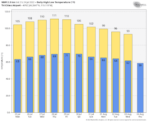
But eastern Washington will be a different story....and a hot one. Highs will climb to 110 or 111F on Wednesday through Friday, with lows dropping only to around 70F.
That will be unpleasant.
The warm weather will be associated with the building of a ridge of high pressure aloft over the eastern Pacific. The amplitude of this high pressure (or ridge) will be a maximum on Monday evening
500 hPa heights on Monday evening. Red is much above normal
The ridge weakens a bit and moves eastward on Thursday. This slowly changing ridge is why the heat continues so long.
Thursday afternoon
The colors are anomalies for normal in standard deviations.
There are some folks that are concerned about wildfires. The heat in itself will not start fires, although it will contribute to drying of surface fuels. But eastern Washington grasses are already dry enough to burn.
What is needed is ignition and wind. Ignitions we can control (except for lightning). But what about wind?
The big threat is at the end of the heat wave late in the week, as cooler air moves into western Washington resulting in higher pressure there and a greater pressure difference across the Cascades.
The hot-dry-windy index that combines a measure of drying conditions and winds shows high values (yellow and red colors) east of the Cascade crest on Friday afternoon (see below).
We better be careful!

.png)


Thank you cliff!
ReplyDeleteAny comment on the fires in California?
ReplyDeleteForecast highs for Thursday-Friday in Tri-Cities would be daily record highs, but 1 thing to watch at the Pasco airport is the wind direction. If it is out of the north in the late afternoon, which is possible in light wind conditions, temperatures will be held down locally due to agricultural irrigation due north of the sensor - an anthropogenic cooling effect that is particularly notable in high temp, low RH conditions.
ReplyDeleteAdam...that is really interesting. An anthropogenic cooling effect from the irrigated ag to the north. How much of an effect is it typically?..cliff
DeleteOn many hot summer days, it is only a couple degrees. The starkest example though was late in the heatwave last summer. For example, at 1Z the evening of June 30th, Pasco Airport was 109F over 70F (yes a dew point of 70Fin Tri-Cities!) with a north wind of 9 mph and Richland Airport at nearly the same elevation was 118F over 46F. Other stations surrounded by agriculture also recorded similarly higher dew points exceeding 70F and lower max temperatures than over natural surfaces that were more in line with the Richland Airport. It would be interesting to do a more quantitative analysis sometime.
DeleteThe Tri-Cities is in the south-central part of WA. Much of WA east of the Cascades will run about 10 degrees cooler. Still, this is going to be a very unpleasant week. So far, I have been able to cool the house (at 2,240 feet) and not turn the AC on. With the higher evening temps this week, that will not be possible.
ReplyDeleteMeanwhile, the wind energy via the BPA balancing chart has dropped to near Zero.
The 18,000 ft freezing level at Quillayute this Tuesday morning must be a record,or near record,for sure.Hard to believe that the 500 mb heights aren't at least in the mid 590s.
ReplyDeleteWill the BC fire smoke moderate the heat this week?
ReplyDeleteThe wind turbines in this area of southeastern Washington are not turning this morning. However, the fan in my office now pointed at my desk is turning rather briskly. But will there be enough electricity available in the summer of 2030 to keep my office fan turning?
ReplyDeleteEnergy policy analyst Prof. Roger Pielke Jr. notes that at least one coal-fired or gas-fired power plant must be retired every month between now and the year 2035 in order to meet Biden's Net Zero GHG emission reduction targets.
Biden's energy policy advisors have said publicly that his administration will use aggressive environmental and financial regulation to force coal and gas off the power grid. And they will ignore or bypass any court rulings which might interfere with their climate action agenda.
However, the Biden administration has offered nothing so far in the way of a credible plan for replacing the coal-fired and gas-fired generation capacity now targeted for shutdown.
Which means that we will all have to learn to get by with substantially less electricity than we've all been accustomed to having at the flip of a switch. It will be a character building experience for all of us, I'm sure.