First, we had unusual cold, then a freezing-rain ice storm, then heavy rain, and then unusual warmth.
But the weather gods are not through with us.
A powerful storm may develop off our coast on Tuesday.

In such circumstances during ancient days, folks would ask themselves why the gods were angry and ask their priests to intercede with an appropriate prayer or sacrifice. Today, our modern weather priests often blame such storminess on sins of carbon emission and predict doom without the proper response.
Human nature hasn't changed. But in this blog, let's stick to the science.
A Profound Change in Atmospheric Circulation
Let me show you the upper level (500 hPa, about 18,000 ft) weather maps from three days ago (Wednesday at 10 AM) and yesterday at the same time.
A profound change. On Wednesday, a deep trough of low pressure was inland while a ridge of low pressure was offshore, resulting in a strong, cold airstream from the northwest.
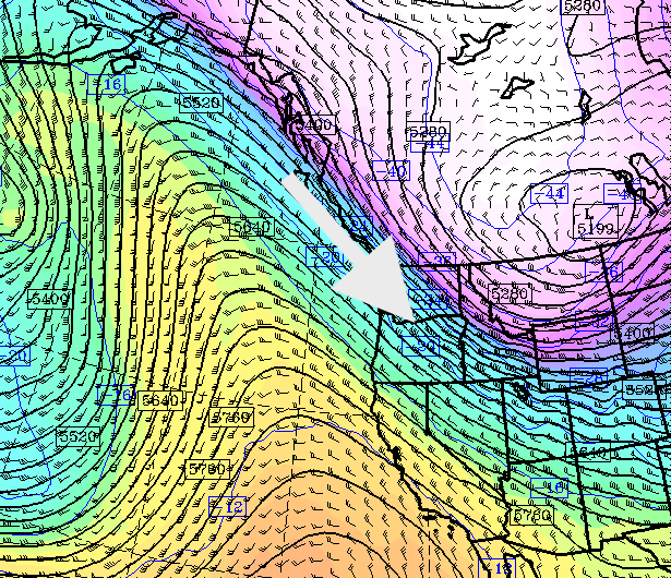
Wednesday
By yesterday, the ridge of high pressure had shifted inland and south, while low pressure has amplified over the Gulf of Alaska. The result is a strong, warm, moist flow from the southwest.
We will be in this pattern for quite a long time.
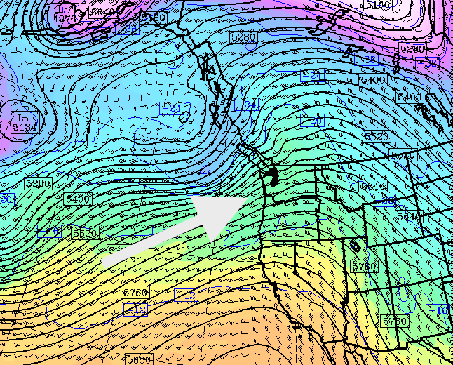
Saturday
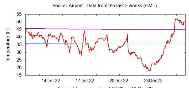
This warming was accompanied by very heavy rain that led to local street flooding. The precipitation over the past 36h has been remarkable (see below), with some locations getting over 5 inches. Over an inch over the Puget Sound lowlands.
The poor ice had no chance. At least the airports can operate normally again. And many of our rivers have filled to bankful.

The Approaching Storm
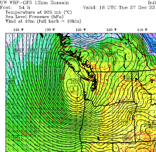
Both American and European models suggest a major low-pressure system will develop off our coast Tuesday morning, with very low pressure.
Here is the UW model's prediction of the sea level pressure at 10 AM Tuesday. A deep 971 hPa low is off the WA coast, with an intense pressure change (gradient) along the Oregon Coast. That means strong winds.
The European Center model at the same time has a 970 hPa low in a slightly different position. There is going to be a major low off our coast. The question is where it will go.
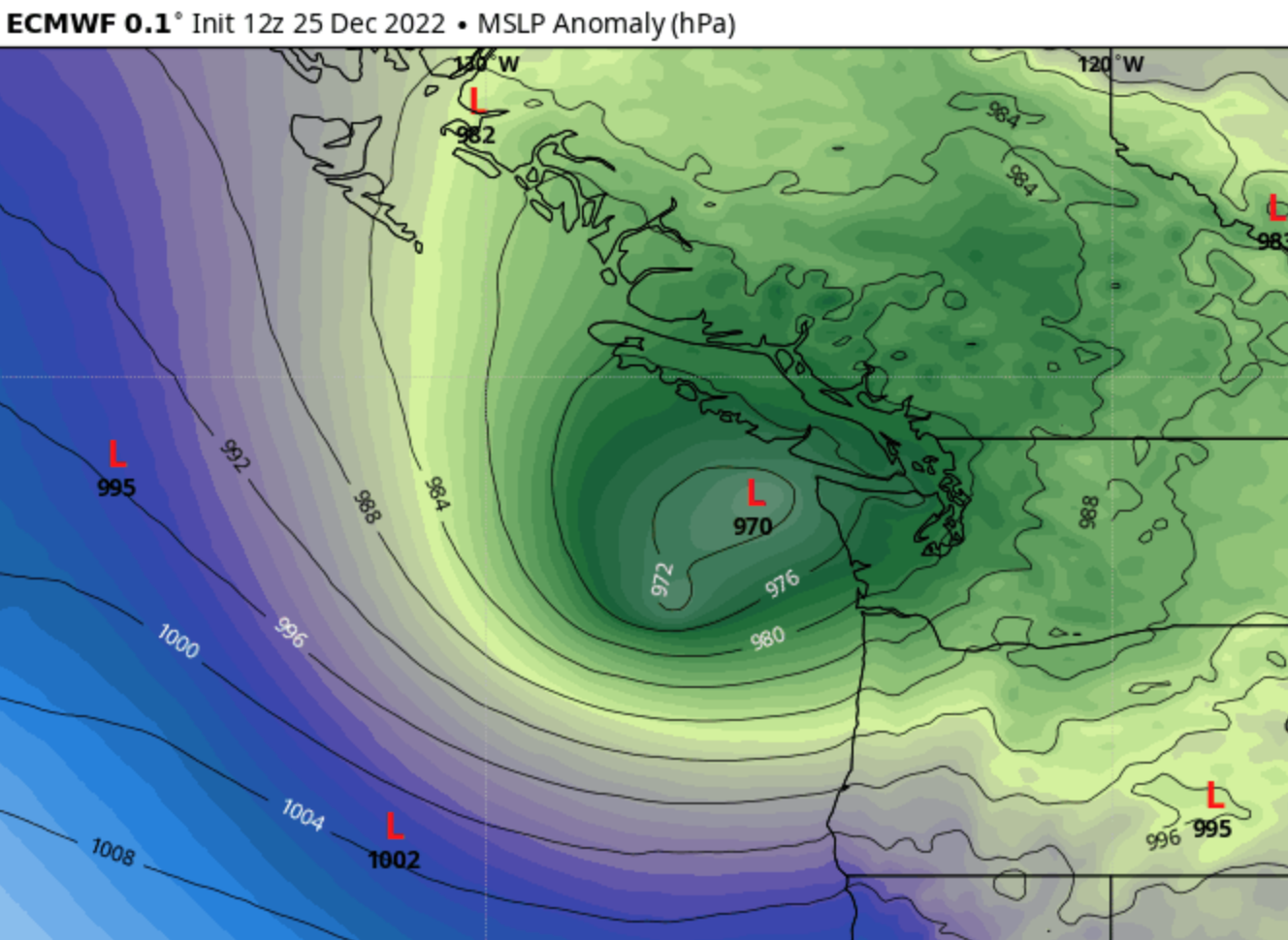
I am confident now that the Oregon coast will get a good blow.
The storm will then move east and north, but there is still substantial uncertainty regarding its impact on the interior of western Washington. But 20-40 knots around Puget Sound is not unreasonable.
I will leave that analysis for another blog tomorrow, so stay tuned. But you might consider making an offering in your holiday fireplace.


Noah would have been alarmed with weather events from the past few days.
ReplyDeleteColumbus Day Storm of 1962, featured a low pressure reading of 958...so the upcoming storm is still in the minor leagues!...we hope!
ReplyDelete970 hPa is not in the minor leagues.... represents the depth of typically the strongest storm we get each year
DeleteThe good that can come out of a storm with lots of wind is a few poplar trees can blow down in the park that obscures our view of the sound.
ReplyDeleteAs far as I can tell the forecasters missed the blow here last night. We had a maximum gust of 59 mph at the Bellingham Airport. (And a maximum temperature of 61F.) These kinds of winds are not that unusual as we typically get them 3 to 4 times each Fall and Winter, but the forecasters seem to not have seen it coming, which is unusual.
ReplyDeleteThe Columbus Day cyclone's minimum central pressure of about 960 mb really wasn't that unusual among the other big storms of history [7]. For instance, with a minimum pressure of 954 mb, the December 1995 storm was deeper, as was the November 1981 storm's 958 mb [8]. However, the Columbus Day winds were much stronger than the 1995 and 1981 storms. The 11-station average peak gust figures used on this website reveal this: 61.4 for December 1995, 65.9 for November 1981, and a screaming 80.5 for Columbus Day 1962 [9]. The Big Blow of 1962 was the only storm to break 70 in the 11-station measure for the 1950-to-present era, and it accomplished this by a large margin! The Columbus Day Storm is an outlier, a singularity.
ReplyDeleteMy understanding is overall severity of a windstorm depends on a number of factors, not just absolute minimum pressure. Other factors include the gradient and the duration. The 1962 Columbus Day storm is widely regarded as the most damaging in recent history. I was a senior in high school in Portland and got to experience the storm and its clean-up firsthand. I've been through the other storms, including living on a sailboat in Portland, and they really did not hold a candle to the 1962 storm.
DeleteYup!...I was 15, trying to deliver my newspapers when that "outlier" monster hit. Like you said, a few other, smaller but deeper storms have hit us, but not with the overall, sustained, massive intensity that the Big Blow gave to us!..Experts in this field, think W. Washington probably only gets hit with such massive storms, maybe once every 200 years....it does sound like this predicted storm coming our way will be super-strong, but at least it is not "turbocharged" from the remains of a hurricane named Freda!
DeleteThis comment has been removed by a blog administrator.
ReplyDelete