There has been a lot of discussion in the media and elsewhere about the recent flooding in Seattle's South Park neighborhood, and others have noted high water levels on the Sound shoreline, including Alki Beach and Tacoma (see some pictures below).
The origin of the flooding is described in this blog.
To give away the punchline, the flooding was the result of an unusual astronomical setup producing King Tides, extreme low pressure from a powerful storm, moderate rainfall, and a human-caused vulnerability in South Park that should have been dealt with years ago.
Although some are making unfounded claims about climate change, global warming played very little role in the flooding event, something I will prove to you below.


King Tides
The key aspect of this event was the King Tide, very high high-tide levels resulting from an unusual astronomical alignment of the Earth, Moon, and Sun.
As many of you know, tides are the result of the gravitational attraction of the moon and sun on the oceans and large bodies of water. When the moon is closer to the Earth (in perigee) tides are large. When the sun and moon are aligned (as in full or new moon) the tides are higher. And when the Earth is closest to the sun (which occurs in early winter!!) tides are higher.

This week all of these factors were near optimal, producing a high-amplitude King Tide, with NOAA predicting King Tides reaching 12.9 ft above sea level on December 26 and 27.
Below are the predicted (blue) and observed (red) water levels for December 25-27 in Seattle from NOAA. The forecasts were excellent on December 25th but greatl underpredicted the actual maximum water level (about 15 ft!) on Tuesday, December 27.
But why such a large error? Global warming did not suddenly show up for a few days. It has to do with the low pressure associated with the incoming storm on Tuesday.

Low Pressure Produces High Water Levels
It turns out that a regional low-pressure center caused localized water level increases, something called the inverse barometer effect (see figure).

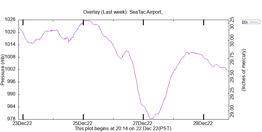
The sea level pressure above western Washington was EXTRAORDINARILY low on Tuesday--the lowest of 2022. Want proof? Here are the pressures at SeaTac Airport for the period.

Here is a close-up view of the pressure this week at SeaTac. Mama mia! Down to 978 hPa/mb on the 27th. Folks this is very low pressure for the interior of western Washington. Water levels would be much higher as a result.
So we start with an unusual astronomical setup, with high tides we only see a few times a year. And then we get extreme low pressure that happens to occur on the King Tide day.
But what about the rainfall?
The major low-pressure system/cyclone making landfall on Tuesday brought moderately heavy rain to the region, with 2-3 inches falling on the western slopes of the Cascades over December 26-27. 1-2 inches fell over the lowlands during the same period. Heavy but not exceptional.

This moderate rainfall drained into the Green/Duwamish River, which started out considerably BELOW NORMAL (see the Green's river level at Auburn below). The substantial rainfall resulted in water levels rising to normal levels on December 27th and about 2 feet above normal on December 27th. (note that hollow diamond symbols indicate normal levels)

So we had an unusual astronomical configuration, a storm with unusually low pressure, and moderate rain associated with the storm. The astronomical and pressure effects resulted in a high tide about 3 feet above normal in the Sound.
Sea Level Rise
How much might sea level rise, which is only partly due to a warming Earth, contribute to the high water?
Below is a plot of sea level in Seattle over the past 120 years. You will notice that sea level has gone up about 2.07 mm per year. That is 4 inches during the past 50 years. That certainly does not explain what happened earlier this week. A very small contribution.
An interesting point is that sea level rise is not accelerating during the past decades, something one would expect if global warming was the dominant cause. Also sea level rise has been going up for a long time...before mankind could have been the cause. In short, the contribution of global warming to regional sea level rise is highly uncertain and certainly small at this point in time (it will increase later in the century).

The Human Cause of the South Park Flooding
The South Park area has flooded repeatedly during the past century, which is not surprising: it is located on the historical flood plain of the Duwamish/Green River. The "river" next to South Park is a totally artificial human-constructed channel.
But the big problem is that during high tide the stormwater drainage pipe for the area CAN NOT DRAIN INTO THE RIVER. So appreciable rain brings flooding.
This is an essential flaw in the drainage engineering of the region and the City has known this for decades. Here is a quote from a City of Seattle website:

Today they are constructing a pump station to reduce the problem.

.png)


Excellent post in every respect. Thank you for directing attention to the facts.
ReplyDeleteLet me add that this winter's early start (low temps and early freezing, snow in the Cascades beginning in November) contributed to most local rivers' low flow levels. Despite the recent (and very brief) warm rain, the mountain snowpack remains deep (WSDOT can attest to that); winter is far from over. In most respects the weather-water situation falls well within the range(s) observed over many years. The King Tides ("all tides") plus frozen grates, storm drains, and blocked culverts contribute to various flooding scenarios.
Keep the good information coming. The "voice of reason" is much appreciated.
Fax them the data! Clearly they need some consulting.
ReplyDeleteMost like SDOT, UW and Seattle Times would dismiss Prof. Mass' data, just like they do on every other relevant fact if it countradicts their global warming narrative. That's the tragedy of our nation given today's media, universities and politicians-- who voters in the Puget Sound metro region keep re-electing.
DeleteShockingly, the Seattle Times did allow the following quote to be published.
Delete"(National Weather Service meteorologist Steve) Reedy said it was a confluence of factors not tied to climate change." Perhaps the editor that let that slip thru is already canned.
GlacierBake wrote: "the mountain snowpack remains deep"
ReplyDeleteDrainage issues abound in the region. A slow coming of spring without heavy rain-on-snow will be necessary or flooding events will be numerous.
Thanks for the summary, charts, and informed comments.
Cliff you said recently that the land around here is rising faster than the sea is rising. So I presume that is absolute sea level rise that you discuss in this blog, not relative to the land?
ReplyDeleteYang, Wang and Miller (2017) developed a model for storm surge tidal events in the Salish Sea. Your post on the poison tail storm matched what one could call the 'perfect storm' for weather related tidal surges per the modeling. It not only was low pressure, but the wind direction piled water up against the coast. The astronomical alignment is not unusual; it happens every year. It is a yearly roulette of whether or not a storm such as the one this week will track in at same time as the king tides.
ReplyDeleteNote that coastal flooding from this event was wide spread. Coastal dikes in Skagit County were overtopped and Olympia appears to have broken its previous high tide water mark. No nearby tide gages at Skagit, but anecdotal from old timers was it was the worst tidal flood. It flooded last year as well. It would have been worse but Dike District 5 raised the dikes in the district last summer. There are some localized effects as well with greater surge in some locations than Seattle. Port Townsend tidal surge was 2.5 feet.
Sweet and others (2022) do note that the rate of sea level rise has increased including for the Pacific Northwest via satellite altimetry data (see their figure 2.1 b).
One could say that sea level rise over the past 50 years contributed about 15% to the water level in Seattle. That contribution is certainly enough to result in the frequency of these events changing from 100 year events to somewhere on the order of 10 or 20 year events. If you add 15% to the tide level across the length of the tide curve plot it is not an insignificant contribution particularly to the volume of water that is incorporated in the flood. If a King tide without sea level rises just reaches flood levels, the 15% increase in tide levels contributes 100% of the flood.
Dan.... I don't think the threshold approach you are using is valid. And it certainly no valid to claim that a 15% increase contributes 100% of the flood. The sea level rise is a small addition to the major contributors: King Tide and low pressure system, with heavy rainfall aiding the flooding..cliff
DeleteCliff, I am not disagreeing with you regarding South Park flooding. But rainfall played no role in the Skagit delta. I should have stated that the dike overtopping in Skagit was by about 3 inches. The relatively small contribution from sea level rise to the total water level pushed the event over the threshold for flooding. This is an issue where inches matter.
DeleteI did caveat that if the king tide was at just below flood, that 1@5 percent makes a big difference.
In addition, wind pushes the water ahead of it. A shoreline on the windward side will see higher water level than a shoreline on the leeward side. The stronger the wind and the longer the fetch, the distance without obstruction the wind is blowing over the water, the greater the effect will be.
ReplyDeleteKen... the role of the wind pushing up water depends on the orientation of the coast versus the wind. It can also go the other way with offshore winds. In this case, the winds were generally southerly---up the Sound from the south, we only a modest onshore component.....but this could have contributed in some places.
DeletePort Townsend, on a peninsula, had coastal flooding on its southeastern, windward, side and routine high tides on its northwestern, lee, side at the same time in this last serious weather. We see the opposite with a king tide, low atmospheric pressure, and northwesterly or northerly strong winter winds.
DeleteSilverdale also experienced a good bit of coastal inundation (putting waterfront roads and such under a foot or two of water) during this highly unusual event.
ReplyDeleteSo when will Kitsap communities get their pump stations? 😉
As always, appreciate the weather knowledge!
ReplyDeleteMy understanding is the root cause of flooding in the South Park Neighborhood is it is built in a flood plane. A look at the topo maps for the area show areas that are only 2-3 feet above sea level. As a result, the Duwamish overtops its banks during high water events. And when the water is high, the normal drainage pipes in the area no longer drain back into the river because they are underwater. There are also a number of other complications that exacerbate flooding even when the drainage pipes are working, including the condition of the streets, the auxiliary drainage pipes, and various businesses not connected to the storm drainage system. Part of the solution is a pump station, but when the river is high and is over-topping, it will flood as the pumps will not have the capacity to counteract a significant flood. When the over-topping event has passed, the new pipe and pump station will assist earlier drainage, but it will not prevent the flooding. Typical other solutions, such as dredging and increasing the height of the river bank are possible, but it is very expensive and there are a lot of environmental issues associated with disturbing sediments in the Duwamish, which are heavily polluted. Development in flood planes creates lots of problems.
ReplyDeletePlease forgive the two typos. It should be flood "plain" (not the aeronautical type).
DeleteNeither the ST nor you (in this post) mentioned the critic long-term role that "developer" (commercial and reidential) lobbying of politicians all around country to allow 'development' even in areas doomed to failures like this, which politicians (regardless of political party) go along with because ... $$$ from larger taxes
ReplyDeletewell, that is true. There is a lot of development in flood plains and coastal regions all over the world.
DeleteAs indicated in my comment to an earlier comment, I would be interested in the quantification of the inverse barometer effect. That earlier post put it at 15". While there is a rule of thumb of 1mb=1cm, that is only a rough guide and I can see there are a large number of variables that would make this calculation very complex in the real world. I appreciate that if you are already in a flood situation, every inch can make a difference. However, it is not at all clear to me that in the South Park Neighborhood flood, how much this contributed.
ReplyDeleteThis comment has been removed by the author.
ReplyDeleteJust checking with back of the envelope sanity check: Typical deep cyclonic depression barometric shift downwards= 30 millibar ==> 3000 Newtons/m^2, so the hydrostatic equilibrium is densityXgravityXheight=3000 Newtons/m^2, implying a height of the upward dimple of water of 0.3 meters = 30 cm, right in line with the rule-of-thumb offered earlier i.e. 1millibar gives 1 cm. To my eye, 30 cm does not seem huge (1 foot), but what was the estimated wind-push effect?? Really amazing, anyway, how close-to-the-margin humans choose to live (or rather than choose, just ignore the consequences.)
ReplyDeleteI think the 1mb=1cm is a theoretical maximum effect. Without a great deal of factual analysis of the numerous factors affecting the flooding in the South Park neighborhood, it is very difficult to ascertain what part of the flooding is due to the extreme, but transitory, low pressure in the region. But as I also stated earlier, if you are in flood situation, every inch over the bank of the river can make a difference as to the total effect.
DeleteCliff, over the past two days (Jan 9-10) we are seeing tides in Seattle about 1.5 ft higher than the NOAA predictions. Local atmospheric pressure is not particularly low - per the Seatac Airport observations, about 996 hpa on yesterday morning (9th), 1004 this morning. Could this be due to the persistent low pressure off the coast you have blogged about recently, leading to a higher overall ocean level? Is it time to combine weather and tide predictions to anticipate flooding events? Flooding and the resultant damage can be a matter of inches, especially when other atmospheric factors weigh in - wind, waves, river levels etc.
ReplyDelete