You knew it was colder than normal over the Pacific Northwest during April.
But the cold was not limited to the surface. Let me show you the chilly story in a very new way: using satellite temperature soundings in the vertical.
By measuring infrared or microwave radiation emitted by the atmosphere, satellites can measure how temperature varies in the vertical. Not unlike how infrared ear thermometers work by sensing the radiation emitted by your eardrum!
Below are the differences from normal of the April temperatures in the lowest 10 km (lowest 33, 000 ft) of the atmosphere, with normal being the average for 1991 through 2020.
Blues are colder than normal and yellow/oranges are warmer than normal. This map and associated data were provided by Professor John Christy of the University of Alabama in Huntsville, who is a well-known expert in such work.
The coldest temperature anomalies (differences from normal) over the entire planet are found the Pacific Northwest, with the deviations from normal exceeding 2.5 C! (4.5F). A blow-up for the Northwest is shown below.
But there is another point you need to consider: there are all kinds of temperature anomalies all over the planet, including a major warm anomaly over Kazakstan.
Differences from normal, both warm and cold, are....well...normal. These patterns occur naturally as troughs (low pressure) and ridges (high pressure) move and develop.
But there is more! This cold anomaly over the Northwest is the COLDEST ever observed since the beginning of satellite temperatures collection (1979). This is shown in the plot below.
You will also notice something that else that is very important...there is little long-term trend for April temperatures over our region. This is consistent with the observation that our snowpack has shown little long-term trend over the region.
May is Not Any Better
And now the depressing part. May is also turning out to be cool....and wet.
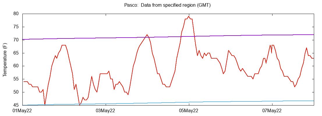
At Sea Tac Airport, every day but one in May has been below normal, with highs on many days around TEN DEGREES below normal.
Slightly better in eastern WA, with Pasco's temperature reaching normal highs twice this month.
The silver lining in all of this is that with lots of precipitation and cold temperatures, the snowpack has surged to well above normal for the entire state (see below). Late ski season. Delays wildfire season. Lots of water for the summer.
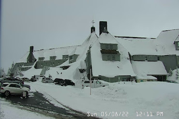
During the last 24 hour, NINETEEN INCHES of snow has fallen at Timberline Lodge on the slopes of Mt. Hood. Amazing.
And now the REALLY depressing news for lovers of warmth. The latest European Center ensemble forecast for the next ten days predicts MUCH cooler than normal temperatures over the region.
No wonder my tomato plants are unhappy......


What comes down must go up,at some point we'll make up for this cool wet spring with extreme heat this summer, there always two sides of a coin.
ReplyDeleteTim...that is not true. There is no yin and yang with weather. There is no reason to expect a period of extreme heat this summer....cliff
DeleteTim, I sure hope so! Last summer was how I wish every year was!
DeleteWe have had cool wet springs in the past that we're followed by hot dry summers so I find it hard to believe that this summer won't be or can't be hot and dry. It's my understanding nature likes to balance itself out.
Deletethere have been plenty of cool springs followed by cool summers, and warm springs followed by warm summers. It is not as simply as you are suggesting.
DeleteThere does appear to be balancing on a global level. Just look at the map Cliff posted: lots of temperature anomalies in both directions. I'd be very surprised if there is any data to suggest there's any localized "balancing" across seasons.
DeleteRough balance over the whole earth on incoming and outgoing warmth. Does not imply a rough balance on any particular area. (Global warming means a slight surplus coming in)
DeleteI fondly remember the year when you said it was OK to plant out tomatoes in April, I think it was 2016. You were right! Consolation prize this year, my tulips may bloom all summer, many have been going strong for weeks!
DeleteYou know better than to plant tomatoes in in April Cliff! Spinach loves this weather though!
ReplyDeletewell...I put it in last weekend, with a mini plastic greenhouse around it. But not enough sun!...A friend of mine tried the "walls of water" approach and said his tomatoes are ok....
Deletedelay to wildfire season, but will all this moisture end up providing MORE fuel for a late fire season? I hope not
ReplyDeleteHas any data come out that shows a cooling effect from the Tonga eruptions back in January? Thought it might be related to that in some ways.
ReplyDeleteGood for skiers and fire suppression, maybe, but not for outdoor swimmers, hikers, and other summer-dependent sports. If we have to have wet, why can't we have warm and wet?
ReplyDeleteTen degrees below normal is pretty dismal in April and May, but ten degrees below normal will be fine with me in June through August. I am perfectly all right with highs in the 60s in summer, especially compared to the 108-degree days last June. Definitely okay with not going near that again.
ReplyDeleteYes, yes, and yes!
DeleteAnd Amen!
DeleteMeanwhile, California's two largest reservoirs well under capacity https://www.sfgate.com/news/article/It-s-not-even-summer-and-California-s-two-17159088.php?IPID=SFGate-HP-Editors-Picks
ReplyDeleteToo bad CA didn't build the additional reservoirs when the Army Corp. Of Engineers recommended, back in the 70's.
DeleteHere is my film of the second cascade on the Excelsior Pass trail (Mt. Baker Corridor) showing light snow at 3100' on May 8th: https://youtu.be/OmsnANZ7vq8?t=117. They are talking about 127 " of snow on Mt. Baker for April: https://www.mtbaker.us/the-mountain/snowfall-statistics/ That would be some kind of April record. In fact, that total (127 ") would exceed the total for the cumulative previous three April Mt. Baker snow totals (40,23,41). The ski area is now closed. But we will probably see more snow on the Mountain in the May weeks to come.
ReplyDelete