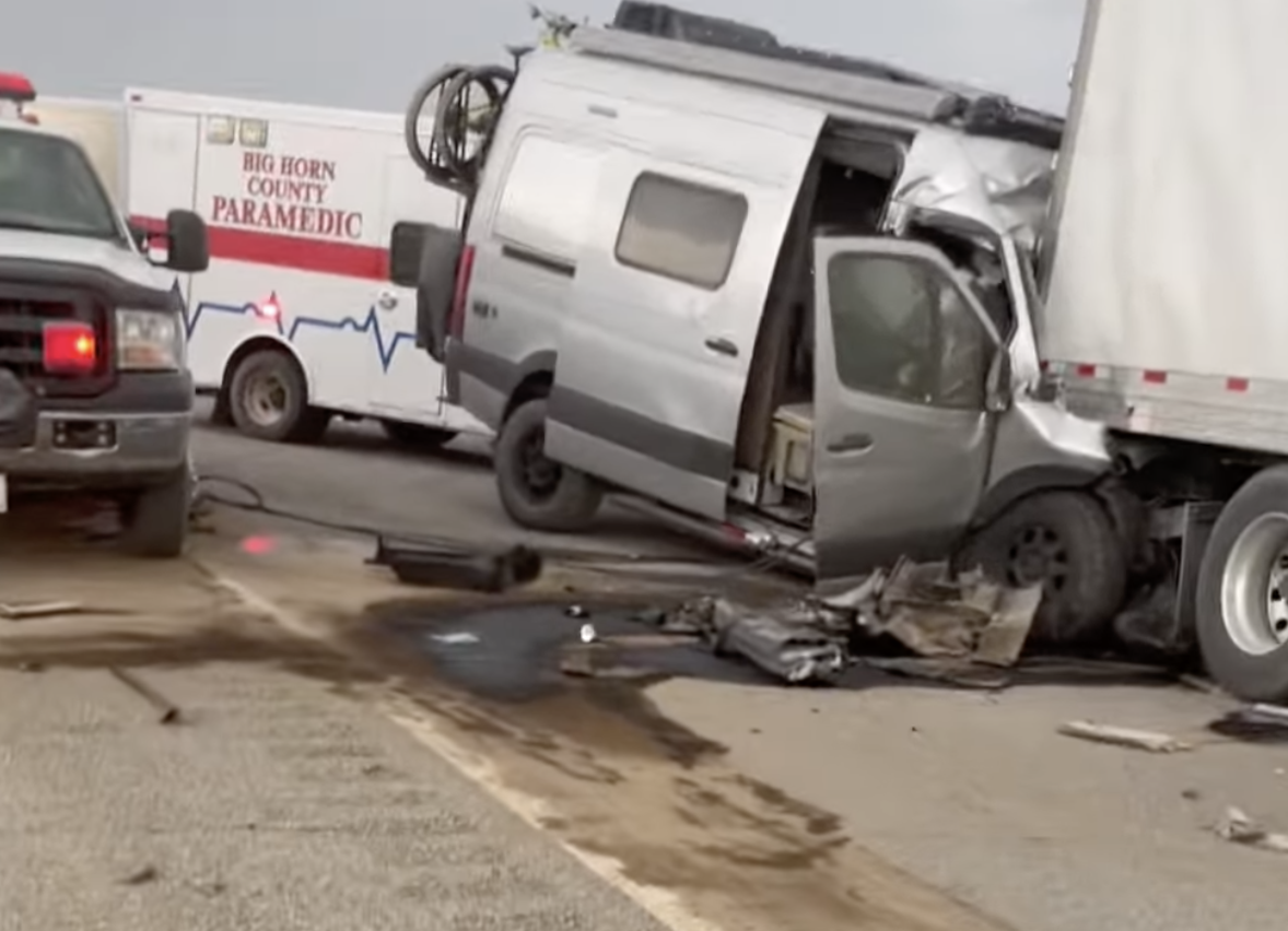
On Friday evening around 4:30 PM, strong winds ahead of powerful thunderstorms pushed across central Montana, resulting in localized duststorms in which visibility declined to near zero in seconds.
As s result, at one location, (Hardin, Montana) a massive pile-up of cars and trucks occurred, resulting in six deaths and many injuries.
Picture courtesy of Jose Strickland
Such massive accident chains during dust storms are not rare. For example, several have occurred in Arizona and eastern Oregon/Washington, such as a 38-car crash near Prosser, WA in October 2003 (my NW weather book goes into this event and others)
We understand the origin of such events, and as I will describe below, there are concrete steps, including new technology and meteorological guidance, that can hopefully reduce the frequency of such roadside carnage.
The Montana Event
The event on Friday occurred on Interstate 90, just east of Hardin, Montana (red arrow on map)
That afternoon, a line of very strong thunderstorms formed over the eastern slopes of the Rockies and moved eastward into the plains. In fact, the thunderstorms were well predicted hours ahead of time by the National Weather Service operational HRRR model (see the forecast of the simulated radar image for 4 PM Mountain Time). The National Weather Service had thunderstorm warnings out for the time.
Radar reflectivity forecast by the HRRR model for 4 PM Mountain Time
The actual radar imagery showed the strong, thunderstorm cells....but more importantly... indicated a strong gust front pushing out ahead of the thunderstorm line. Gust fronts, which are associated with strong wind acceleration and gusts, are produced by the cool, downdraft air produced by thunderstorms (see graphic below).
Gust fronts often are visible in radar imagery because the cold, strong flow in the gust front can push air upwards, producing clouds and some showers that radar can sense.
The National Weather Service radar imagery below shows the situation. The white star idicates the accident site and the white arrow shows the location of the gust front, behind which winds gusted to 50-65 mph.
At 2036 UTC (2:36 MDT)--about two hours before the incident-- you can see the line of thunderstorms and the gust front is evident by the thin line (see arrow).
At 4:20 MDT, just as the crashes began, the gust front had reached Hardin. The radar provided plenty of warning!
Weather Service radars are Doppler radars, which can observe winds as well as precipitation intensity (which is known as reflectivity). Below is the Doppler wind imagery at 3:58 PM. Wow. You can see the gust front clearly with winds of 36-50 knots.

How strong did the winds get in and behind the gust front? Some surface stations reported over 60 mph (see max winds that day below)!
So why was there a dust storm? Because there were plowed fields all around I-90 (see a google ground image below at the accident site)
Winds over roughly 20-30 mph are very effective in picking up dust and dirt from exposed soils, which are found all over the west due to the massive agricultural operations in our region. And dryland farming areas (such as eastern WA and central/eastern Montana) are very vulnerable to strong wind erosion of soils.
Preventing Such Chain Accidents in Dust Storms
Most of these kinds of accident chains happen the same way. Folks are driving fast and too close together. The lead vehicle in a pack hits a region of reduced visibility and hits the brakes. And then the other vehicles plow into that vehicle and each other.
So more responsible driving is certainly necessary.
But there is more. We can warn of such events. Not only were the thunderstorms well forecast but our surface observing stations and weather radars were picking up the wind event HOURS before the disaster.
I repeat HOURS BEFORE THE DISASTER.
Imagine if we created an environmental warning app that could be loaded on everyone's smartphone. The phone would know one's location, and warn you that very strong winds were about to hit you---with an explicit caution about dust storms.
We could do this. And such an app could also warn of other conditions, such as ice on the roadway, flooding on roadways, and much more. Call it the "Driver Protector App."
I proposed to the Washington Department of Transportation that we create such an app for Washington State drivers, but they were not interested. Perhaps one day someone else (maybe Google or Microsoft) might consider doing this. An app that is constantly watching for environmental dangers in your location and giving you a timely warning. We could do it. Could save many lives.
Climate Change?
Unbelievably, some folks in the media, descending to the netherworld of journalism, have claimed that this terrible accident is a symptom of climate change.
The outline area indicated the relevant Montana country.


Professor Mass, technology is a wonderful thing and such a app might well be useful sometime in the future but for now don't humans already come equipped with the best possible detection equipment? Let me suggest that such equipment, when loaded with the appropriate software, would do wonders for driver safety. We come equipped with eyes and approaching thunderstorm fronts are easily visible. The software is the knowledge of the likely winds, etc. that thunderstorms bring. Pull over to the side of the road and let it pass. How hard can that be? Workable?
ReplyDeleteEyes cannot always tell you what the pending visibility is. My scariest drive was westbound on I-90, freeway speed at night. Clearing the summit, traffic immediately dropped into a fog bank with zero visibility.
ReplyDeleteDOT and DOL need to say more about this in driver's Ed. Dust storms are rare enough in much of the country that they don't, but this is a problem with driver training. There should be a policy to warn drivers (and perhaps even a law) to pull over to the shoulder or take the first exit if a cloud of dust presents itself. They warn about driving in ice and snow, and about fog, but say little about dust storms, which are potentially more dangerous than snow and fog.
ReplyDeleteWhat a fantastic idea for an app! It would be hugely useful. Cliff, I think you should float that to some companies that may well make it a reality.
ReplyDeletegood app
DeleteMany apps already try to provide advanced warning of rain/snow based on radar data and your location, and they are terrible at it. Constant false positives, at least here in arid Colorado. Much of what's visible on radar is not reaching the ground. Personally have turned those type of notifications off. Many people do due to the low accuracy.
ReplyDeleteAlso, strong cold fronts and gust fronts in summer thunderstorms would show up like this on radar. Not all of them will have visibility crippling dust at their leading edge.
The people to talk to about this are probably the big trucking companies. Every big rollover costs then a pile of money, and they already have a drivers' info network.
ReplyDelete