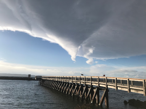
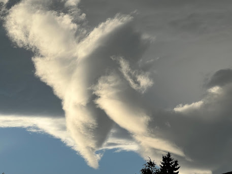
During the past day, I have received several emails and pictures of a strange cloud feature seen from roughly 4 PM to 5:30 PM on Thursday. Let me show you.
Theresa Verway took this picture from Shilshoe Beach in Seattle around 4:12 PM
Steve Moseley took this picture in N. Seattle around 5:18 PM
And here are two views from the Seattle PanoCan, one around 4 PM and the other around 5:30 PM. Note the blue skies nearby....that will be important.
So what caused these strange clouds?
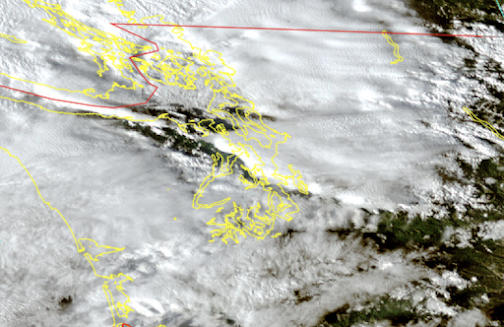
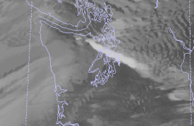
To gain some insight, let's take a look at high-resolution satellite imagery at the same time.....that should provide some major hints!
Here is a high-resolution visible image at 4:30 PM. For a trained meteorologist the imagery suggests a high-amplitude mountain wave forced by the Olympics.
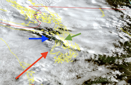
Let me explain, using a marked-up version of the image below. On Thursday, there were strong southwesterly winds (from the southwest) approaching the Olympics--see red arrow. As the air rose on the western side of the Olympics, clouds (and precipitation) were enhanced.
But as the air moved down the northeast side of the Olympics it descended, drying the air and producing a clear zone (see blue arrow).
The movement of the air up and over the Olympics established a mountain wave pattern and the air subsequently rose rapidly downstream, forcing an impressive area of clouds (green arrow).
This high-amplitude mountain wave pattern can be simulated by our best forecast models, such as the UW WRF modeling system. In fact, our model predicted this interesting cloud (see below)
Such high-resolution mountain wave clouds can have very complex structures in three dimensions, and that was certainly the case on Thursday afternoon. So complex that some folks have mistaken these clouds for UFOs--unidentified flying objects.
My podcast today will be about the interesting forecast for this week--lots of weather action and mountain snows ahead!.
___________
To listen to my podcast, use the link below or access it through your favorite podcast service.




Imagine being alive in the early bronze age and seeing these clouds and having your whole city state whip itself up into mass hysteria over it lol. I bet this happened many times in history.
ReplyDeleteAhhh, the beginning of BS. Seeing something, not knowing what it was, then making something up to explain it (the Gods are angry, happy, etc.). My how things have not changed.
DeleteStaring at cloud formations really can make one see things that are not really there!...One of those photos strikes me as being an ethereal, waist-up photo of Jimi Hendrix, holding his guitar over the area of the country he was from!..and no, I am not high!
ReplyDeleteI measured a 39mph gust at my house in Bellingham at 10:25am on 10/30 - the highest of the season so far.
ReplyDeleteExceptionally dark October day in Bellingham on 10/30 - I measured 0.62MJ/m^2 of total accumulated solar energy. Hope you like my comment, Cliff!
ReplyDeleteOutside of Saturday, it's certainly been wet in Tacoma, that's for sure. I was in Olympia for part of the afternoon, and may be a spittle of sprinkles at one point, stayed mostly cloudy with the sun trying to peak through and later in the afternoon, evening, it turned to rain and rained off and on yesterday and it's raining now at quarter to 8 Monday morning.
ReplyDeleteAs you say, this is a classic pattern for this area for late fall/early winter around these parts.