Several of you complained that you miss fall weather. That endless summer is not your cup of tea.
Well, the weather gods have heard your complaints and the forecasts have changed for early next week.
Rain and cooler weather will arrive--but there is more you should know about.
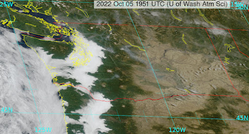
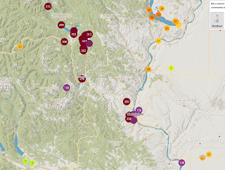
Today is cloudy over much of the west, as the combination of onshore flow, longer nights, and smoke particles contribute to fog and low clouds (see satellite image around noon today). In addition, lots of smoke from the Lake Wenatchee fire is heading towards Wenatchee, with very high particle concentrations hitting the Apple Capitol.
PurpleAir particle concentrations. Purple colors are very bad
This situation will continue through the weekend as high pressure holds in place over the eastern Pacific.
But on Monday everything changes as a sharp, energetic trough of low pressure sneaks around the upper-level ridge and pushes into the Northwest (see upper air map--500 hPa pressure, about 18000 ft-- for 5 PM Mondy)
This trough will bring cooler air from the northwest and rain, dropping the highs on Monday and Tuesday into the lower 60s. You will be thinking about some hot chocolate and your jacket.
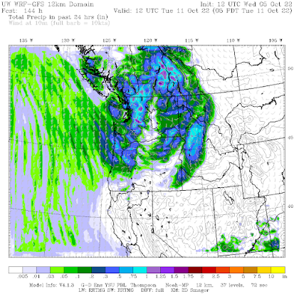
Here is the precipitation forecast for the 24-h ending 5 AM Tuesday morning. A few tenths of an inch in the lowlands, a bit more in the mountains. Enough to wet the ground but no much else.
The trough will move southward into California, bringing some showers and potentially some strong winds into the Golden State (see upper-level map for Wednesday at 5 PM).

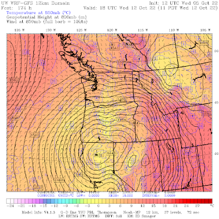
This is a strange pattern for the Northwest, resulting in strong easterly (from the east) flow over the Northwest. You can see this clearly in a low-level (about 5000 ft) weather map for 11AM Wednesday (below)
I worry about this pattern. There will be strong easterly winds over the northern Rockies, which can contribute to wildfire initiation, and this flow would push smoke over western Washington and Oregon. Will examine the situation carefully in subsequent blogs.



The lowland rain might not be much, but I see 1/2 to 3/4 inch forecast for the location of the Bolt Creek Fire, and I think similar for around the Goat Rocks Fire.
ReplyDeleteHopefully this will be enough to finally extinguish these west side fires. And with mild temperatures forecast for Tuesday, I doubt anything will be fully dry yet by the time those east winds arrive.
It's premature to call the end of the wildfire season, but I'm hopeful.
I don't believe that 3/4 of an inch is enough to put out a wildfire. Ive been through a burn area a few weeks after several inches of rain and it was still smoldering and burning underground with intense heat radiating from the soil.
DeleteIt depends what is burning, I suppose. Large diameter stuff that can keep smouldering underneath through the rain could flare back up as things dry out.
DeleteOn the other extreme, when we periodically had to burn fields of spoiled crops growing up on a farm, I was always mystified by how we had to be so careful to contain them during the day, but once night rolled around and the fog came, the fires would go out on their own.
I appreciate your optimism about rain's return, but most forecasts point to only a few hundredths of an inch in Seattle on Monday and none in Olympia area. :-( Seems like we're still gonna be stuck in this pattern after Monday?
ReplyDeleteMeanwhile, first signs of a salmon die off have started to come in from the central coast of British Columbia. Once they commit to freshwater the clock starts ticking on how much time they have to spawn and without significant rain, that's going to be hardest on Salmon who have to go a long ways upstream but are now unable to get back home to spawn and also stuck in warm water downstream because of this weather.
I find it hard to be focused on the effects of natural weather cycles on wild plants and animals, which happen every season. Otherwise, I would be very sad every spring when most newborn and hatched young critters perish. But this is the cylce of life. An alternate way to view these naturally-driven weather and resource pendulum swings it is a good thing for the population, driving natural selection, at least in a normal diversified genetic pool. But the unfortunate fact is many of our our native fisheries only exist because of massive (and some now argue counterproductive) hatchery programs, with very poor genetic diversity. But without those programs, the ecologic annihilation we've initiated over the last 100 years would result in very few native fish sightings and most likely extirpation.
DeleteSeems like a whole lot of strange patterns lately. That strong easterly wind event is exactly what I didn't want to hear. Will it last a long time?
ReplyDeleteAs the saying goes, "it is what it is what it is", were just helpless spectators in natures grand spectacle
ReplyDeleteI wouldn't mind endless summer- in the tropics or subtropics. But here, summer means drought, which, over enough time, means desert. Also, this far north, astronomical winter is not capable of sustaining meteorological summer anyway: Short days, low sun angle, cold nights.
ReplyDeleteI'll believe it when I see it. 3rd Week of October is usually when this type of Fall ends.
ReplyDeleteThe models were wrong last week, we didn't get multiple rain events.
Computer models are cool, but they are the products of humans. Humans are flawed.
It's absolutely true that we've had many days without significant precipitation. But n the many years I've lived on the west side of the Cascades our having a "dry Fall" season has not been unusual. If anything, having dry weather at harvest time - perhaps allowing a third, light "cutting of hay" - has been considered blissful. When I summed-up my "rain year" figures at the end of September (new rain years begin Oct 1. Four of the last five rain years averaged 68.63", and this year ended at 79.79" -- 11.16" greater due to 2021's wet fall, then a wet winter and spring. The local 'watershed planners' (for ag) have been using May-Sept for "summer," so I sub-totaled the same months (May-Sept) and for four of the five years our summer precip was 14.04", with this year coming in at 12.13". So -- relatively speaking, and realistically in terms of beginning the summer with extraordinarily strong snow and groundwater reserves -- the dry spell has not resulted in crisis at all. Our local river (N Fork Nooksack, here in the mountains) has been flowing between 1st quartile and median flow to this day, hyrogeologic "baseflow" plus melt. We've been lucky to not have local wildfires, true - but the flora and fauna seem to have been largely unstressed. This summer's temperatures have not been so extreme as some other outlier years'.
ReplyDeleteI honestly don't know how the year has played out elsewhere. I'm definitely looking forward to your future posts. I've rather lost track of Ninas and Ninos, and I'm not sure who can predict what given all signs (nights here have been quite cold, and we're losing daylight) there's good cause to think we're well on the way toward winter rains again.
I read somewhere -- Farmers Almanac maybe? -- that we're headed for a rare 3rd La Niña winter. This means plenty of rain. Here's hoping! 🙏🙏🙏
DeleteI’ve heard that the GFS is showing us bone dry even until the third week of October.
ReplyDeleteForecast changed, no more rain. In fact, no rain on the weather maps for at least another 2 weeks. Unbelievable.
ReplyDeleteEuro model is showing us dry as well. The scary thing here is that the entire U.S. west of the Mississippi is in drought, and a lot of it is severe. Yes, we have had dry falls but I don't recall any of them with as much smoke (163 here yesterday) as this year.
ReplyDeleteParts of our essential ecosystem are dying. Look at the trees. Check out https://www.theguardian.com.../environment/2022/oct/05/...canada-dead-salmon-drought-british-columbia
ReplyDelete