I have to tell you about this, even though some of the forecasts are crazy extreme.
For several forecast cycles, the models have suggested that later this weekend and next week record-breaking cold and snow hit the region.
Yes, lowland snow.
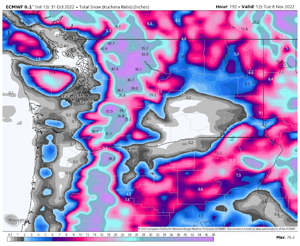
Let's start with the vaunted European Center model. The totals for the next week (through Tuesday morning) are shown below. A dusting over the lowlands and massive amounts (2-4 ft) in the mountains.
The American GFS model is similar with large mountain snows, but it also had a band of 1/2 feet over the south Sound.
And the U.S. GFS has even more lowland snow through Thursday. Furthermore, the totals through mid-November are sheer madness, with nearly 2 feet over Seattle. The American model has problems.
The accumulated snow over the next week by the UW model is also substantial over the mountains and has some lowland snow over western Washington. Folks....we may be skiing by Thanksgiving.
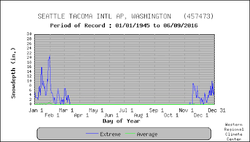
As shown by the climatological snow graph below, getting any kind of lowland snow during the first two weeks of November is basically unprecedented.
Anyway, thought you should know. I will keep watch on these forecasts since there is a lot of uncertainty for such extended predictions.
What you can depend upon are cooler-than-normal temperatures (including highs only getting up into the mid-40s) the next few days in the lowlands and bountiful mountain snow.
The origin? A strong trough of low pressure along the coast (see upper-level --500 hPa pressure--map for tomorrow morning), with the blue and purple colors showing much lower than normal heights (or pressures) aloft.
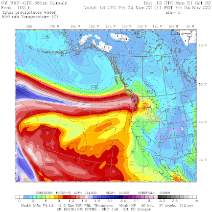
And we are confident that a powerful atmospheric river will bring a plume of moisture to the coast on Friday, resulting in substantial rain and mountain snow (see the forecast of total atmospheric water vapor for Friday, below)
So don't worry about wildfires, drought, or lack of snowpack---we are now entering a period of massively cold, wet weather. The yin and yang of the weather is quite evident.


Global colding
ReplyDeleteI'm not buying it.All the models I see show the coldest air in the trough remaining off the coast during the period.In that case,common sense and climatology would indicate that a relatively mild SW flow off the Pacific would result.Lowland snow would be highly unlikely.( Although the mountains would get heavy snow)
ReplyDeleteIn those model runs,are there any indications of a strong arctic air mass building? If there was a deep arctic airmass blasting down the Fraser,with like a 15-20 MB pressure gradient from a Williams lake to Bellingham, then,sure, there could be some snow in the northern Puget Sound.
Even in that scenario the sw flow would be cold enough for snow above 500'. If it were January then that would be to the surface.
DeleteActually the models are forecasting that. Steady NE winds from Frasier Valley and E/SE for central and southern sounds. Forecasted single digits in Williams Lake at that time would also corroborate the cold air coming down. Will it happen, who knows, but the setup forecast is what we would need for lowland snow.
DeleteMaybe you should start a blog?
ReplyDeleteAlthough I miss the snow at times here, i dont relish any snow or ice in Portland. They're incapable of handling even a dusting, the entire area becomes frozen in place, and the drivers panick and start going off the roads at the slightest slippage.
ReplyDeleteLots of snow in Nov. a drought it does NOT break. You know that. Why say it?? Jerking the Sealttle-istas chains?? I understand. Even one wet wet winter won't eliminate the drought or fire hazards next year.
ReplyDeleteChristmas could be coming early for folks like me who LOVE Lowland snow.
ReplyDeleteNo lowland snow in today's WRF-GFS run from UW. I'll be keeping an eye on the updates, though.
ReplyDeleteBy the way, I know where to find UW's forecast maps, but is there a good publicly accessible resource you recommend for the European Center forecast maps? What about the ensembles you sometimes show? Thanks!
ECMWF outputs are fairly restricted. You have to pay to get access to the full suite. However, windy.com and tropicaltidbits.com have some of the info depending on what you are looking for.
DeleteThank you for the URL's. I will check them out.
DeleteWhat happened to the lowland snow!?
ReplyDelete