Well, the weather gods are delivering. Heavy rain is falling throughout the region, except in a small rainshadow area around Seattle.
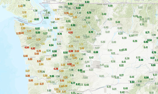
Totals so far have been impressive, with some rain gauges measuring 4-5 inches on the western side of the mountains (see below). But less than a tenth of an inch over the Kitsap Peninsula. Mama Mia! That is rainshadow.
The freezing level is now around 10,000 ft and the snow level is about 9000 ft.
A strong cold front will move through early Saturday, bringing much colder air into the region and snow will return to all the mountain passes. Be careful if plan cross-pass travel.
But the real cold air and the potential for lowland snow will not occur until Monday, when a low center will move southward to the central/southern WA coast and Arctic air will push into southern BC. (see the latest sea level pressure and low-level temperature chart for 10 AM Monday). Every place in blue it is cold enough to snow. White areas could have snow. Purple is VERY cold.
Strong cold, northeasterly winds will surge out of the Fraser River Valley into Bellingham, cross the San Juans, and then plow into the Olympics late Sunday and Monday. These folks will see some snowflakes.
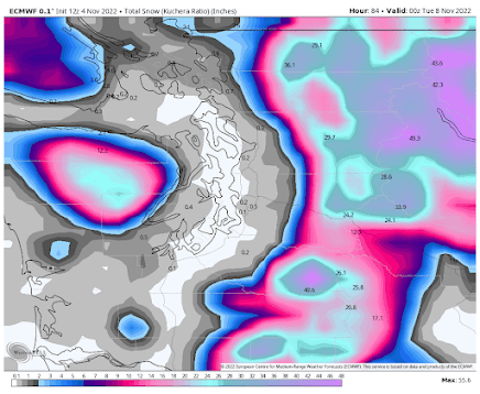
Let's look at some of the latest forecasts for snow (the forecast totals from this morning at 5 AM through Monday at 4 PM). The European Center model has lots of snow (up to 4 feet) over the Cascades and a swath of light snow from Bellingham to the Olympics. Very low snow levels. But little near Puget Sound.
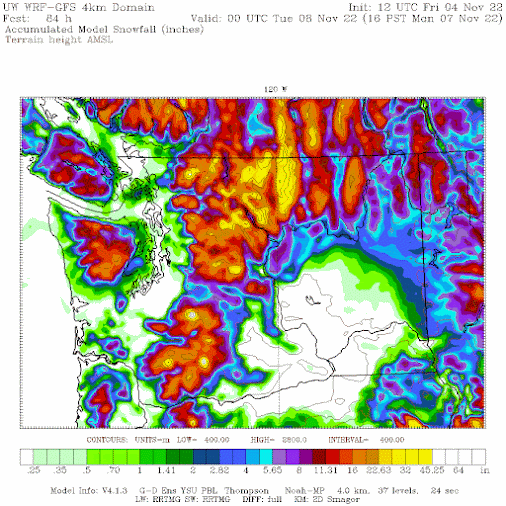
The higher resolution University of Washington model also has snow over Northwest Washington, as well as snow at low elevations east of the Olympics and even over the higher terrain north of Seattle. Lots of snow over northeast Washington.
Any lowland snow is unusual the first week of November. More details in my podcast, which provides details on some of the challenges for snow forecasting in our region.
To listen to my podcast, use the link below or access it through your favorite podcast service.
Some major podcast servers:
Like the podcast? Support on Patreon


Hey Cliff, what do you predict for lowest low (overnight) temps during this stretch for Seattle Metro?
ReplyDeleteIs there some reason that the rain shadow has been gotten wrong so often? Perhaps not location but intensity? It's not like someone just dropped off some mountains the other day and this is all a new phenomenon.
ReplyDeleteAnother early snow even was in 1985. I recall that one well. Unofficially, the accumulations on our deck were near a foot in Tacoma. At that time, I was still living with my parents in the West end of town that occurred right after Thanksgiving if memory serves, and the extreme cold that had the snow staying on the ground for about a week. Seems I read that both a wet, warm atmospheric river and a cold front from the Frazer River Valley collided and stalled out, giving us that snow. I recall others, like 1990, again, was living here in Tacoma when that one took place so didn't experience the thundersnow that took place that afternoon over downtown Seattle.
ReplyDeleteRemember the one from 1996, 2012 and vaguely recall the Hannakah storm of 2006 and definitely the one from 2008. I was living right on the corner of Melrose and Thomas Streets where the 2 buses slid down Thomas and almost dropped onto I-5 below. They were still extracting the 2nd bus when I came home from work that day.
Of course, the snows from the past couple of years too, including the snow of 2019 as well.
Another very dark day in Bellingham - I measured a total solar energy accumulation of 0.49MJ/m^2 on 11/4.
ReplyDeleteSurprised no one is talking about that squall that just tore through Snohomish and Island Counties. NWS and the local news are not mentioning it. Absolutely nuts out there. My parents got multiple trees on their roof in Tulalip. Sirens everywhere here in Bothell.
ReplyDeleteYou say rainshadow isn't it just dry air called shear and a small eye of rotation probably is the cause of that 104mph gust at crystal mountain and my grandpa says what rain....its dry in Yakima
ReplyDeleteWe got absolutely hammered here in Portland. Worst storm in years, the wind gusts took down the power grids where I live for almost twelve hours, massive 100+ years old trees uprooted all over the neighborhoods. The flooding was also incredible, mud slides in the Gorge and 100+ mph winds recorded at Mt. Hood.
ReplyDeleteStorm total rainfall for 11/3-4 at my house in Bellingham was 2.49" with ~85% of that on 11/4.
ReplyDelete11/4 was another very dark day in Bellingham - I measured just 0.49MJ/m^2 of total accumulated solar energy.
ReplyDeleteThe barometric pressure got rather low last night - bottoming out at ~992-993mb in Bellingham.
ReplyDeleteWow, Eric! We really got hammered here near Mt Baker in the last 24 hrs, but not to that degree, There were wild winds blowing just above the treetops; I could hear cells approaching (like a freight train) and howling overhead. There were tree limbs snapping, but no trouble trees fell on any structure but some local roads were blocked by fallen trees.
ReplyDeleteThe DOT plowed debris from state Hwy 542. The wind caused multiple outages, and hail fell even this morning just before the 7 am CoCoRaHS report time. It's nippy - 36-40 F high and I see fresh snow on all the surrounding mountains, pretty much at the elevations predicted by the NWS forecast. I remember many early cold seasonal starts like this (even taking kids out on Halloween in snow), so... Off we go! Not over yet by a long shot.