We enjoyed an unusually dry, temperate mid-November, and Thanksgiving Day was a pleasure, but now the brass knuckles of a La Nina winter are about to be revealed.
Cold air and a hard freeze will hit the entire state next week, with massive mountain snowfalls that will delight the ski community.
All of us should take steps to deal with the upcoming cold, from unscrewing outdoor hoses, and protecting pets, to ensuring that the region's large homeless population is brought inside or protected.
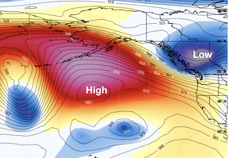
The upcoming situation is a classic for a La Nina winter, in which the central and eastern tropical Pacific is colder than normal. During such winters, we typically observed a large ridge of high pressure developing over the northeast Pacific, with cool, northerly (from the north) flow on its eastern side (see the forecast upper-level map for Saturday at 10 PM as an illustration).
If there are disturbances in that northerly flow, moving south out of Alaska, we can get bouts of mountain snow, and if these troughs are positioned just right, then lowland snow is possible.
As in any good drama, the action can be separated into several acts.
Act 1: Initial Cooldown and Mountain Snow.
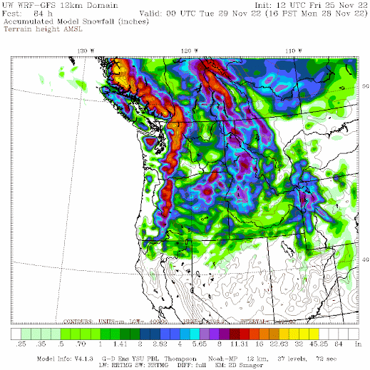
Today (Friday), a cold front is moving through bringing plenty of rain to the region and snow at higher elevations. On Saturday night and Sunday, a trough of low pressure will move in, producing further cooling and lots of mountain snow. Take a look at the totals through Monday at 4 PM. Several feet in the mountains!
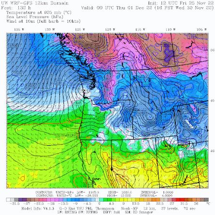
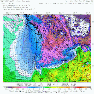
By Tuesday morning, cool air behind the upper-level trough will move into the area (see forecast map for 4 AM Tuesday). The colors indicate air temperature around 2500 ft. Blue indicates air cold enough to snow, and purple show frigid, arctic air. This arctic air is associated with high pressure, resulting in low-level northeasterly winds in the Fraser River valley that will start moving into Bellingham and its vicinity.

Act 2: A Second Trough, Colder Air, and Potential Lowland Snow
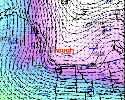
On Wednesday, a second trough will move southward out of SE Alaska (see upper level (500hPa pressure level) forecast below for 10 AM Wednesday). Not perfect for lowland snow west of the Cascades, but close.
This upper-level trough produces upward motion and precipitation, and will be associated with a surface low center that will move across the central WA coast on Wednesday afternoon (see sea level pressure forecasts, with low-level temperatures below).
This pattern will also draw cold air into northwest WA.
This cold air will then move southward and by Friday morning, the entire region will be cold. VERY cold east of the Cascade crest. CRAZY cold east of the Rockies of Montana.
The question will be about precipitation, and thus snow. The latest UW WRF forecast is producing some lowland snow. To illustrate here are the 24-h snowfall totals ending at 4 AM Thursday. Much of the lowlands get several inches.


Weather model watching is an art form. Can't wait for next week...
ReplyDeleteWell, snow or no snow I know what's coming, a brutal northeaster out of the Frazier valley, a direct hit like every year. The wind is the worst part.
ReplyDeleteAny lowland snow is a monkey wrench for Seattle Transportation
ReplyDeleteTell me about it, lived in Seattle and lived through several of the major snows since the mid 90's. Was in Tacoma for the 1985, and 1990 big snows so missed the thundersnow that began it all for that one, but do recall, with clarity the atmospheric river that hit in Nov, flooding areas like Skagit County and Fir Island, then the cold hit in Dec, causing massive amounts of cows to freeze in the icy cold.
DeleteI was on Capitol Hill when the storm hit on Hannakuh Eve 2006? the big snow of 2008, and had two tour buses almost fall onto I-5 in front of my Apt building while I was at work, and they were still extracting when I got home around 6pm.
With Greg Nickels not wanting to plow the streets, for fear of "damage", Metro was basically shut down as most of their fleet was stranded, with many buses within the city itself. I was able to get around OK with a RWD Ford Ranger, just by going at it gingerly the times when I was needing to drive to work.
Temp dropped to -3 here in Kelowna in the last hour. All the slush turned to ice. Gonna be road mayhem tomorrow
ReplyDeleteAnd cue "lowland snow event" hype #2 for the season. Current record stands at 0-1 in favor of much ado about nothing. We'll see what the record at the end of the season is. My prediction is 2-7.
ReplyDeleteWhen was the first lowland snow expected? This is the first one I have seen and it looks pretty accurate so far.
DeleteIn Port Angeles we were hammered by the last 'hype', well, at least above 300 ft.
DeleteI follow you on twitter, but never see your tweets. I believe you are being shadow banned.
ReplyDeleteWhy is the temperature forecasted to be warmer on Wednesday than Tuesday?
ReplyDeleteJust finished picking up the leaves again. Please bury the garden under snow for a few weeks. I need a raking rest.
ReplyDeleteCliff.... looks like a potentially decent setup for Kitsap/Hood Canal. The system doesn't appear too weak, might have reasonable precip rates here which can result in quite a dump. With strong precip rates it often takes a bit longer to turn to rain in the canal than models expect. We'll see how it develops. GFS this morning had 3-6 inches, this evening looks like 4 to 8 or even a bit more
ReplyDeleteBen, what is GFS? :)
Delete