When we get to within approximately 72 hours before a weather event, powerful high-resolution tools become available, and these can be critical with the complex terrain of our region. Let me tell you what these tools are telling us.
The Super Rainshadow
The atmospheric river has now made landfall on western Washington and rain has spread eastward across the region. As predicted, a profound rainshadow is apparent on the latest radar image, with essentially dry conditions over much of Kitsap County east of the Olympics (see below).
The latest super-high resolutin forecast for precipitation over the next 72 hr (below), shows a distinct rainshadow, with less than .5 inches northeast of the Olympics, while up to ten inches is found over the mountains. And eastern Washington gets super-rainshadow action, will nearly no precipitaitn around Yakima.
And if you like the sound of wind in the trees, there will plenty of that tonight and tomorrow morning, with a huge north-south pressure difference predicted for 11 AM Friday morning. Expect southerly winds gusting to 20-30 mph everywhere and over 40 mph along the coast, over Puget Sound, and over NW Washington.
Trees will lose branches and some may topple in this early season blow, so be careful out there.
Finally, the cold/snow situation is becoming clearer. The fact that we will get much colder, with temperatures far below normal is pretty much guaranteed from Sunday onward.
Here is the forecast anomaly (difference from normal) for 24-h ending Tuesday morning at 10 AM.
Large portions of British Columbia and Montana will be MORE THAN THIRTY DEGREES below normal. Much of Washington and Oregon will be 10 degrees below normal and more.
I will be getting my sweaters out of the closet. And municipalities will have to do what they can to protect homeless people. Yesterday I saw one individual on the Burke Gilman trail without even a shirt on, with several others sleeping on benches or in the woods adjacent to the trail.
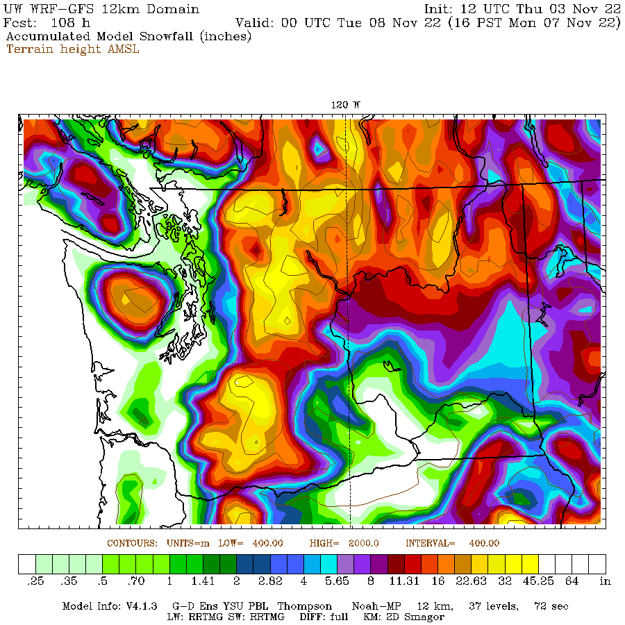
And then there is snow. The mountains will be buried in the white stuff-- feet of snow--as shown by the predicted totals through 4 PM Monday from a relatively low-resolution forecast (12-km grid spacing).
It is looking quite possible that the western lowlands will see some flakes, but I need more resolution to get this right...and I will have that tomorrow.
But there are two areas of the greatest threats. Later on Sunday and Monday, cold air will push out of the Fraser Valley into NW Washington, increasing the chance of snow from Bellingham into the San Juans. Some snow will fall on the northeast side of the Olympics as the Fraser outflow is forced to rise. And a Puget Sound convergence zone may form around Seattle producing a band of snow over the mid-Sound (hinted in the above figure).
More on this tomorrow and Saturday.


There are also the inevitable mountain pass closures thanks to unprepared drivers.
ReplyDeletePlease kindly stop advertising how often Kitsap is rain shadowed. We really don't want that getting out. AKA we don't want more people moving here. In all seriousness, it was interesting to view the weather radar and Green/Gold Mountain creating their own rain shadows.
ReplyDeleteInterestingly, when viewing the GOES West 18 Conus, the system seems to be cycling clockwise viewed from space and approaching Bellingham from the NW, yet the surface winds are definitely SE. Hmmm. I'd lkike to hear that explained.
ReplyDeleteAlso, at this writing, it is barely raining here and the wind is light to moderate. Earlier, NWS forecast gusts to 55, since downgraded, while Wunderground was predicting 10-20 with gusts to 25. The airport is currently reporting SE 9. We'll wait and see of course, but ...
Bring it on! What's a few more extreme records for the year??
ReplyDeleteGet it all out of the way, and hope next year goes back to "normal"...
Thanks for the advance warning, Dr. Mass. Looks like we're in for a weather potpourri.
ReplyDeleteBack in 1973, I scored some Hockey tickets for my friend and myself to go see the totems play at the ol' seattle center coliseum... at sixteen we were finally able to drive downtown and watch the kelly and green play...on the way home we encountered snow squalls that really did not do much but slush up a little....beyond that, except for 10/27/71..[two inches before halloween]..never seen flakes before about 11/21/85...what a month that was...anyways, it is rare and fun to talk about...thanks
ReplyDeleteAs of 4am today...in S. Everett...very little rain, and we will see if and when the predicted heavy gusts actually show up...I am going to keep my small bedroom window open, in order to hear the possible high winds.
ReplyDeleteWoke up to....not much!...as of 11:30am, in S. Everett, hardly any wind, and very light rain...I guess the notorious Rain Shadow has extended South?
Delete