We are much closer to the potential events this week: close enough in time to have the higher-resolution models available.
As I will explain, the upcoming situation has the potential for lowland snow but is not optimal. Heavy snow in the mountains is a sure thing.
The SnowTrick
Let me remind you, it is hard to get lowland snow west of Cascade crest. Moist air coming off the Pacific is too warm for lowland snow, and it is difficult for cold air in the continental region to reach us because of the blocking effects of the Rockies and Cascades.
So to get snow we need something exotic to occur. The most popular trick is to get a low center off the southern Washington coast and cold high pressure over the BC interior. The difference in pressure causes cold air to be drawn southwestward through the Fraser River Valley or across low terrain into NW Washington, which then spreads southward. The low on the Washington coast and an accompanying upper-level trough of low-pressure results in rising air that produces precipitation that falls into the cold air near the surface.
That can lead to snow.
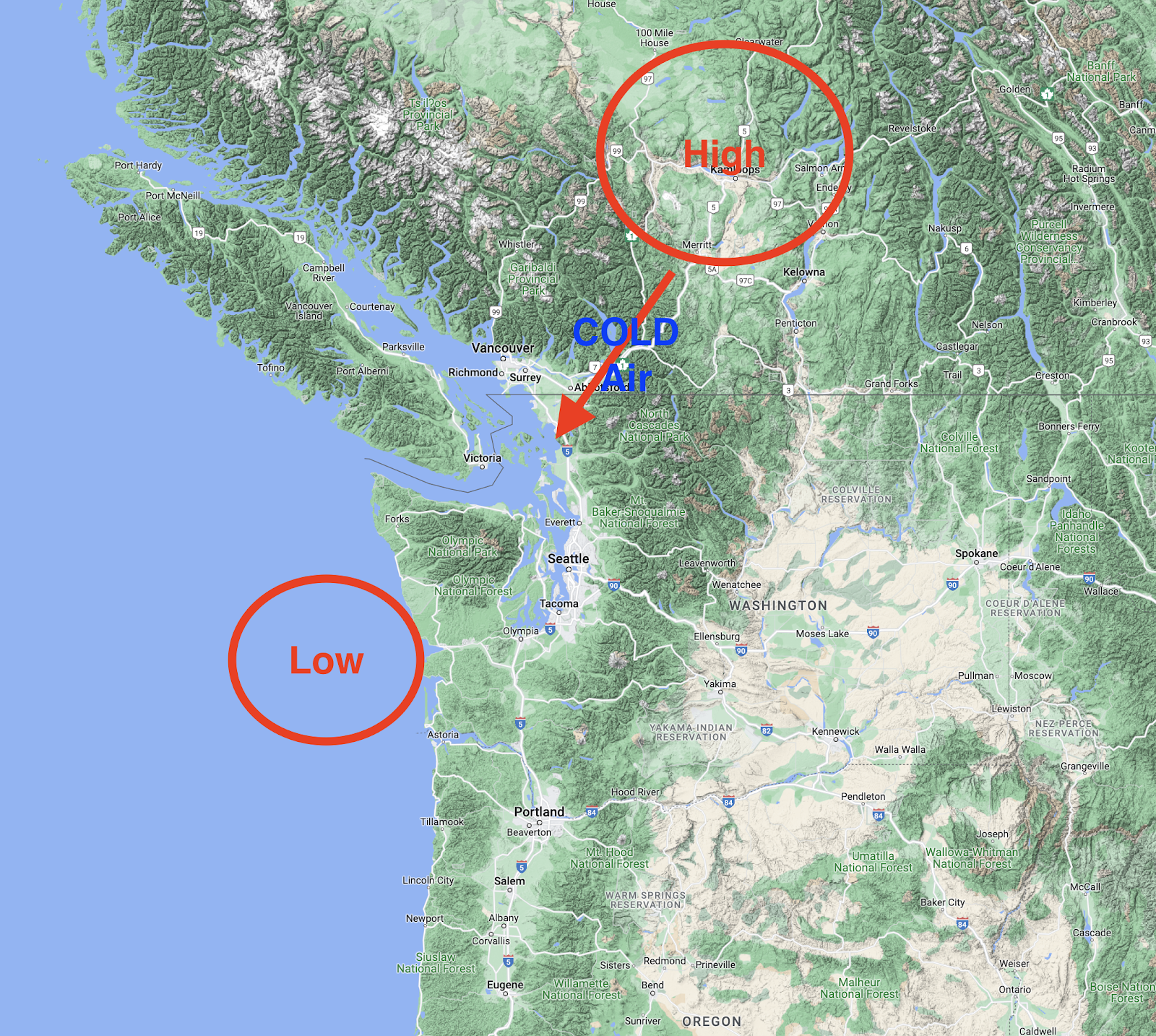
The other way to secure lowland snow is to have cold air in place (from the above), while a front pushes inland. Precipitation starts as snow and then turns to rain.
We may get a bit of both this week.
The Current Situation
Last night a relatively strong cold front moved through and temperatures aloft (and near the surface) have fallen substantially.
The cold front also produced a surge of strong northwesterly winds in the Strait of Juan de Fuca and downstream around Everet, producing wind gusts as strong as 50-60 mph last night (see a plot of gusts below). A few thousand customers lost power.

Tonight, a weak low will move over western Washington, and cold, high pressure will build into British Columbia (see forecast surface map for 4 AM Monday). Blue colors are cold enough for snow by the way. Monday morning will bring a hard freeze to western Washington will lows in the 20s.

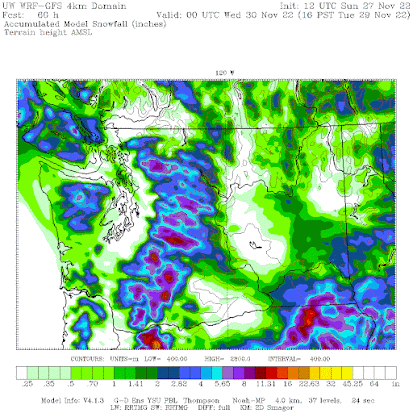
Cold, unstable air will be moving into the Cascades during the next day, with some snow accumulation in the mountains (see total snowfall through 4 PM Tuesday below)
The Wednesday Situation
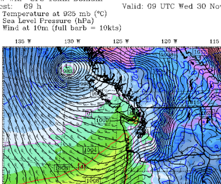
The big action will potentially occur on Wednesday. A strong upper-level trough will approach, producing preicpitation over the area....where cold air will be in place (upper-level map shown for 4 AM Wednesday)

A strong surface low will approach northern Vancouver Island, with an associated front making landfall on the Washington coast Wednesday morning (surface map at 1 AM Wednesday is shown). This front will eventually drag in warmer air, but the precipitation could well start as snow at low levels on Wednesday morning. Large amounts of snow will fall in the mountains. I
The latest UW high-resolution forecast for snowfall through 3PM Wednesday is shown below. Many feet in the mountains, but note the band of snow from Seattle to Everett (several inches). Eastern Washington will get some snow as well. Snow depth will be less than snowfall, of course.
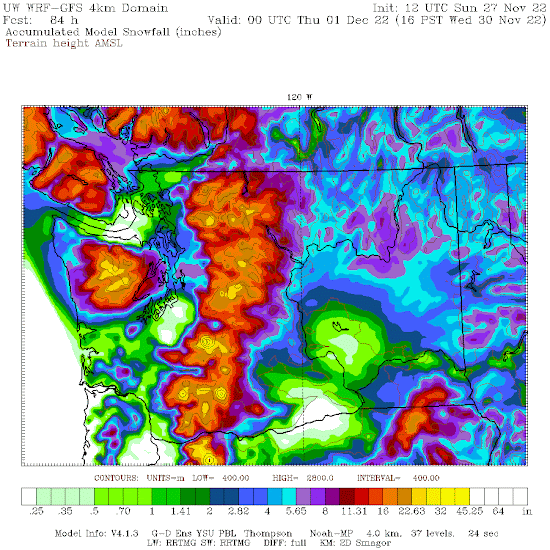
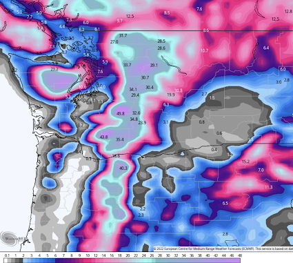
The lower-resolution European Center model has a similar solution (see total snowfall for the same period..now until 4 PM Wednesday). Lots of mountain snow, snow over NE Washington, and a band of lowland snow from Seattle to Everett.
Our confidence in the Puget Sound snow forecast will increase as we get closer in time and high-resolution ensembles become available.


So Cliff initially what you're saying is that the kitsap peninsula should be ready for some lowland snow possibly over 5 inches.. based off the current models..?
ReplyDeleteNo it never pans out to anything. The only snow we ever get is when no weather folks even predict it...
DeleteIts just for higher elevations it looks like.
DeleteCentral/North Kitsap/Hood Canal are all in pink. According to the map elevation is irrelevant.
DeleteKitsap Peninsula looking to get dumped on if models stay on course.
ReplyDeleteIn Belfair we're I live in don't think will see snow right at sealevel that's mainly for the higher hills on Kitsap Peninsula.
DeleteReporting here from Oyster Bay (West Bremerton)... the 1-1/3 WRF was bang on with the timing and snowall -- no accumulation but plenty o' flakes around 11am today.
DeleteJust saw the new GFS this evening. It is pretty consistent the last few runs. Solid for Kitsap if this setup holds. GFS is even higher in this run, 8 to 10 inches along the canal.
ReplyDeleteBen...unfortunately you can not believe the GFS for snow around here...cliff
DeleteCliff...the 1.33 KM domain is more accurate, correct? Does it show incredible snowfall along hood canal or what....24 hour totals of 12 to 16 inches
ReplyDeleteThe local forecasts are probably leaning toward 2-4 inches on Kitsap before rain change. Maybe some freezing rain thrown in the mix. Seems to be what the newsies are hinting at anyway. So, it could be a messy Wednesday AM for those heading to the Yard and Bangor. Who knows. The default is Rain and then Rain Shadow so that could be all we get while Sequim and PA get buried.
ReplyDelete