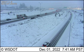
The forecast models did a good job on this morning's snow event, which was mainly to the southeast of Seattle and over southern Puget Sound country. 2-4 inches fell in places and the I-5 corridor near Tacoma looked like Alaska (see below)
But ANOTHER snow event is coming. And I don't want to hype this...it is not going to be a major snow event. It will be a complex, marginal event that tests our modeling systems' fidelity.
Tomorrow night, a low center will move off our coast, while cold air is in place over the region (the map below shows sea level pressure--solid lines--and low-level temperatures--color shading at 10 PM Friday). A weak front will approach our coast, spreading some light precipitation inland.
Complicating the situation, there will be easterly (from the east) winds driven by a strong east-west pressure difference (higher pressure to the east)
The latest UW high-resolution forecast of 24-h total snowfall ending at 4 AM Saturday shows bountiful snow on the southeast side of the Olympics (see below).
Strong uplift by the easterly flow hitting the Olympics will be a major contributor. Kitsap will get snow. And so will central/north Seattle and southern Snohomish County.
There is a lot of uncertainty with this forecast. I know this because our high-resolution ensemble prediction system (in which we run the model many times, each with minor variations in initialization or physics) is all over the place (see snow prediction for Queen Anne, Seattle, below). From zero to 7 inches!
We will have a more confident forecast tomorrow.
Finally, I can't help but mention the front page story in the Seattle Times today (see below), claiming that climate change is resulting in sea level rise on the northwest Olympic Peninsula.
This is bogus and wrong.
Although global warming IS causing a slow rise in sea level around the world, sea level is actually dropping or not changing along the Olympic coast.
Why? Because the Olympic Peninsula, and particularly its western side, is RISING. Why rising?
Two reasons. First, the peninsula was pushed down by the great ice-age glaciers and is still rebounding after the glaciers retreated more than 15,000 years ago. Second, there is a subduction zone off our coast, which causes the land to rise to the east.
Want some proof? Here is the sea level at Tatoosh, on the NW corner of the Peninsula from a NOAA website. Sea level is dropping there.


Cliff: I appreciate your informed views about climate (mostly informed from weather observations over the last century?), and about many of the details of science on the news media, which tends to focus on clickbait.
ReplyDeleteBut there are a couple of things that it would be helpful for you to address:
1. The science of ice cores from Antarctica that track climatologic changes over the last millennia
2. The drought and water shortage of the SW, particularly https://www.washingtonpost.com/climate-environment/2022/12/01/drought-colorado-river-lake-powell/
Dang! Was hoping for a good storm! ❤️
ReplyDeleteDang! Me too!
DeleteClimate change is causing increased coastal flooding regardless of the minute local rise or fall of the land mass. Because of climate change, the reservation is now more flood prone. Isn't that what the article says? Also, there are measuring stations closer to the Quinault reservation that show sea level rise. It's not sea-level rise that's causing the flooding. It's global warming.
ReplyDeleteCan't understand your comment. The article blames sea level rise from global warming. Sea level rise from global warming has little to do with this flooding
DeleteSea level rise, stronger storms, more intense rainfall, all are "climate change". Despite the rising land, sea levels along the Pacific coast are rising, not falling. Neah Bay is subject to very different tides, as it is north facing and inside the straight. Willapa Bay is a more "apples to apples" comparison location and the sea levels are rising. https://www.researchgate.net/profile/Paul-Komar/publication/261964104/figure/fig4/AS:650402567557120@1532079464757/Decadal-trends-in-annual-average-RSLs-for-the-shorter-PNW-tide-gauge-records-from-Willapa.png
DeleteCliff, I would like your opinion on why, as the Indian elders claim, that the ocean used to be a football field away from the Quinault village when they were young and now it is lapping at the village doors. If sea level is not rising, but their shoreline is, what is going on here?
ReplyDeleteThere are many possible causes. If the sediment load in the Quillayute river changed (which their village is on) that would alter the coast. If sand moving up the coast changed....the same. A long list. And that is assuming their memories are correct.
DeleteThere is an interesting article at this link about the dynamics of the river:
Deletehttps://www.researchgate.net/publication/222511199_Flood_Plain_and_Channel_Dynamics_of_the_Quinault_and_Queets_Rivers_Washington_USA
You may also be interested in "Washaway Beach" - - Official name is North Cove.
It is an old story.
I haven't looked into the Quinault's concerns much, but since it was brought up, my initial curiosity prompted me to start with looking for historical photos.
DeleteThis photo on the Quinault nation's own website shows a shoreline that looks pretty much the same as I see in newer photos and on Google's aerial imagery:
http://quinaultindiannation.com/planning/images/tahold.jpg
There are many possible causes. If the sediment load in the Quillayute river changed (which their village is on) that would alter the coast. If sand moving up the coast changed....the same. A long list. And that is assuming their memories are correct.
ReplyDeleteBeaufort Gyre, Solar Particle Forcing, Weakening Magnetic Fields, CMIP6 data vs. CMIP5 comparisons would be interesting since so many people parrot the term global warming without actually understanding it, or more importantly, understanding why the data they consume is skewed for political purposes (how quickly we forgot the global cooling scares of the 70s...)
ReplyDeleteYes, there are so many possible explanations for literally anything. The MSM (mainstream media) sure loves emotional knee jerk explanations with no data to support their claims on many things. Cliff is a fresh breath of logic.
ReplyDeleteWisdom is being able to entertain any idea or explanation without accepting it. Cliff is a breath of fresh logic.
ReplyDeleteWhy I support your blog instead of subscribing to the Time.
ReplyDeleteCorrection corner: The Quinault Nation is located on the Quinault River. You're maybe thinking of the village at La Push on the Quillayute. They've already made efforts to move uphill. Seems like the tsunami hazard and flooding is enough reason in the short term to move, sea level rise being the long term threat. Assuming it overtakes the rate of coastal rise at some time. Either way it's good to be prepared and coastal communities especially those already marginalized need to be resilient
ReplyDeletecliff, i'm curious why you devote so much time to "debunking" climate change advocates, while mostly letting deniers off the hook.
ReplyDeleteMr. Man.... First, using the term "deniers" is not good...it is riffing off the Holocaust. Let's use skeptics. Skeptics don't control the main newspaper in town. Don't you think the Seattle Times should be providing the public with facts and the best science?. And what skeptics should I be fact checking? Please be specific...cliff
DeleteConcrete hard sea level dropping data. Fax this to the times. =)
ReplyDeleteWell it's been snowing lightly since 5 am here above Hood Canal at 500', steady all day so far and just under freezing. Snow is showing the SE wind so looks like things are trending early here.
ReplyDeleteAlways enjoy your weather expertise. I always cringe when I see you swerve four lanes to discuss climate change. Two items to consider:
ReplyDeleteGeodetic evaluation of sea level (https://blogs.egu.eu/divisions/g/2022/09/28/geodesy-sea-level-rise/).
NOAA station selection. Consider the NOAA graphs for northern Pacific stations. (https://tidesandcurrents.noaa.gov/sltrends/regionalcomparison.html?region=USNP). It is apparent that along the Washington coastline that sea level hasn't changed too much and specifically along the Strait, Neah Bay station is an outlier. Neah Bay, Port Angeles, and Port Townsend should all experience similar rates of isostatic rebound but may experience slightly different rates of subduction related uplift. The sea level data suggests local geodynamic controls around Neah Bay may be affecting the observed sea level reduction and should be considered in conjunction with other available data.
Cliff - you are indeed correct that both ice removal uplift (isostacy) and land rising owing to strain building in the upper plate of the subduction zone as we all await the next full-on subduction zone rupture are driving sea level "decrease" on the Olympic Peninsula. Climate change is not a factor. But I will point out that when the subduction zone quake does occur all of that accumulated strain-induced uplift will evaporate in a matter of minutes - and those villages would be toast from both the ensuing tsunami and the catastrophic strain release.
ReplyDeleteThe comment about the land moving up due to faulting action is true, but only temporary. It will descend again after the next M9. If you want to learn more about local faulting, you may want to consult with your colleagues in Moore and Johnson halls.
ReplyDeleteI find that the more I venture out of my area of expertise, the more my biases affect my understanding. Please be more careful when you post about things outside of your field.
Please see the following link for more information about the vertical displacements post M9 if you are interested. I am sure you could access local models for post earthquake vertical ground displacement at specific sites. https://www.dnr.wa.gov/publications/ger_ic116_csz_scenario_update.pdf
DeleteI'm trying to find where it says that about isostatic rebound being reset or eliminated in your link. I can't find it
ReplyDeleteOf course, Tatoosh isn't exactly close to Quinault. The Climate Impacts Group at UW has developed some great visualization tools that show you, among other things, vertical land movement is estimated to be 0.9 feet at Tatoosh and -0.1 feet in Quinault.
ReplyDeleteAnd of course, in the case of a major subduction quake, all bets are off.
Yes, this is true of Neah Bay. However, Neah Bay does not represent the entirety of the Olympic Peninsula. Some of the closer monitoring stations to the Quinault Reservation (e.g., La Push, Westport) do suggest rising sea levels (see p. 98 of the Global and Regional Sea Level Rise
ReplyDeleteScenarios for the United States, February 2022). Another chart with historical trends supports the other factors that you note are occurring in Neah Bay and large parts of Alaska, but not for other parts of Washington's coast. https://tidesandcurrents.noaa.gov/sltrends/regionalcomparison.html?region=USNP
I agree that the Seattle Times could do a better job of providing information on other aspects of this with Neah Bay as a prime example, but the primary point of relative sea level rise occurring along the Washington coast seems largely supported with your noted exception. This appears to be especially true around the Quinault Reservation.
I'm not sure the exception of Neah Bay is proof that relative sea level rising is not occurring (or dropping) along the Olympic Peninsula. It appears to be more of an outlier than anything else. I'm far from an expert though.