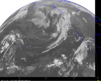
Unfortunately, we have begun the transition out of the fine, sunny weather we have enjoyed during the past two weeks. Take a look at the latest infrared satellite image this morning...a line of moisture is streaming towards the NW and if you look close you can see the swirl of clouds associated with a low center off our coast.
Today there will considerable clouds with few sun breaks...temps reaching to near 60F and a few light rain showers. A heavier band of showers is expected tonight and tomorrow am. The story of the weekend will be clouds and occasional showers...but no major systems. I will give the details tomorrow.
An interesting aspect of weather here is the November transition...October can often be quite nice, but during the first two weeks of November we rapidly transition to the worst weather of the year. The last week of November is our meteorological black hole...the stormiest, wettest, windiest period of the entire year. Barbeque turkey is a NW tradition for a reason....


I noticed today that the leaves are really coming down, we got hit by several huge yellow maple leaves. So sad the wetaher is changing; it's been a fantastic fall this year. Can we post pictures in these comments, by the way???
ReplyDeleteMark...this has been a tremendous year for color... I think that is because of the dry, sunny period we have had with color mornings... not sure about posting pics with comments...cm
ReplyDeleteI took some pictures along highway 203 (Preston to Duvall) last weekend:
ReplyDeletehttp://www.flickr.com/photos/liem/
Is it possible for you to make the state outline darker, and more clearly delineate the land/water boundary? That would make the maps easier to use.
ReplyDeleteAlso, could you make them larger?
Cliff, just a note. You cannot leave images in the comment section. However you can leave links to images. For instance click here to see a photography I took monday night that has some great fall colors.
ReplyDeleteTell me more about the BBQ turkey!
ReplyDeletewhat is the forecast for this winter?
ReplyDelete