Powerful winds have pushed through and downstream of regional gaps in the Cascades and other regional mountain barriers.
Consider the maximum gusts observed this morning (see below).
There are three swaths of wind exceeding 40 mph (yellow colors). One extends southwest of Bellingham and heads over the San Juan islands and then westward out the Strait.
The other extends westward north of Mount Rainer and out to Tacoma. And another extends from the western Columbia Rivr Gorge and then over Portland and the northern Willamette Valley.
There are a few odd strong winds over some exposed ridges, like one near the Tri-Cities.So what is going on here?
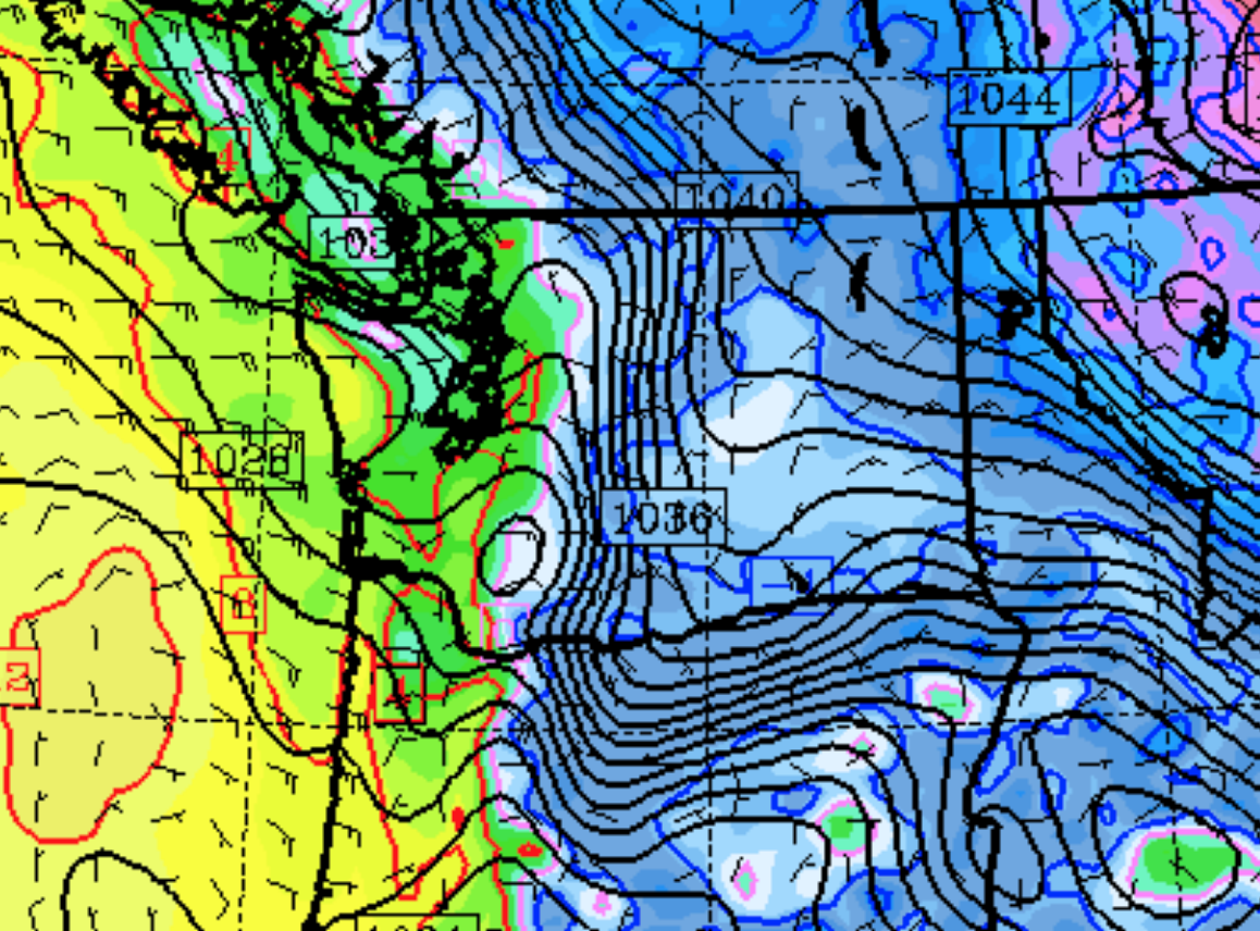
We start with a very large difference in pressure across the Cascades. Sea level pressure (solid lines) and near-surface temperatures (color shading, blue and purple indicated cold air) for 4 AM this morning are shown.
There is a very large pressure difference (gradient) across the Cascades with higher pressure to the east. Cold air is denser than warm air, resulting in higher pressure near the surface east of the Cascades.
This difference in pressure drives winds, which accelerate from high to low pressure.
But there is a problem. The Cascades block the air at low levels!
Thus, air looks for gaps or weaknesses in the Cascades to push through, and as shown in the topographic map below, there are three of them.
One gap encompasses the Fraser River Valley and exits near Bellingham. Another is the Columbia River Gorge, a near sea level gaps across the Cascades. And the final one is the Stampede Gap southeast of Seattle which represents a weakness or lower area in the Cascades.
These three gaps represent favored conduits for air pushing westward from eastern Washington.
An exciting development is the growing ability to skillfully forecast the strong gap winds using high-resolution regional models.
To illustrate, below is a 24-h forecast of the winds exiting the Fraser River gap this morning at 4 AM. You can see the swath of strong winds over Bellingham and the San Juans.
Finally, there is the issue of gap-wind tourism. Where is the best place to experience the regional gap wind phenomenon?
My recommendation is Crown Point in the Columbia Gorge, with the Vista House being the perfect venue. They even have a snack bar!
The winds have gotten over 100 mph at this location. This morning it got to 74 mph.
What could be better than being buffeted by hurricane-force winds and then enjoying a hot chocolate? For a meteorologist or weather enthusiast, nothing could be better.


Your local area weather discussions are one of the more enjoyable portions of your blog to me. However, I find the WRF Wind/WindGust plots almost impossible to read/interpret mostly due to an outdated default color bar. Lots of good research has gone into better colorbars for scientific presentations (stoptherainbow, cmoceans, scientificcolormaps). Is there any way you can change the default on the wind maps to better represent the field of interest? (maybe a light to dark, or bright to dark scale). Thanks!
ReplyDeleteI went up to Longmire this afternoon and saw lots of windblown debris on the roads East of Elbe. There were even a few sickly looking trees downed in this area. Trees in the Longmire area were being blown around more than I recall seeing on previous trips.
ReplyDeleteI like the www.windy.com site for wind (and other layers) status and forecasts. The color 'blobs' make it easy to see the different speeds and directions of winds.
ReplyDeleteAnother good gap wind spot is Squamish at Howe Sound. Big kiteboarding spot
ReplyDeleteI'll second Squamish/Howe Sound as an excellent gap wind/outflow site, especially the venturi by Anvil Island... you really notice it driving up to Hwy 99 towards Whistler, just before Porteau Cove.
ReplyDeleteExtra bonus: Environment Canada has a marine weather station immediately south of Anvil Island at Pam Rocks. You can check out the past 24 hrs of data at the URL below... and for our American/British friends, just click on the "Imperial Units" tab to get rid of the newfangled metric gobbledegook ;)
https://weather.gc.ca/past_conditions/index_e.html?station=was
I can attest to the winds around Crown Point. I live across the Columbia from there and the winds the last week have been insane. These wind storms have never lasted more than three days before. This one has lasted a week.
ReplyDeleteI love the environment here and getting about 25% more rain a year than Portland is perfectly fine with me. But the winter winds are the one thing that gets very old very fast. Now that I drive an electric car I think about how great it is that I now refuel my car indoors and I don't have to stand in the blasting wind to buy gas at a pump anymore!
I welcome the return to rainy weather next week.