Our region will experience wildly gyrating weather extremes over the next week.
Yes...there is still cold and snow in the forecast. But before we enjoy the snowflakes, we will experience a strong atmospheric river that will bring very heavy precipitation to the mountains.
And to spice it up, strong winds and an extraordinary rainshadow will occur over Puget Sound country.
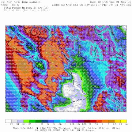
First, the atmospheric river. As shown below, a plume of wind-driven moisture, thousands of miles long, will push into our region on Friday. The figure shows integrated water vapor transport--essentially how much water vapor is being transported by the wind. Let me assure you, these are large values.

Look closely and you will notice that Seattle and its vicinity will get less than .1 inches--they will be in the rainshadow of the Olympics. Why? Because the winds approaching the Olympics will be nearly westerly (from the west), which shifts the rainshadow to over central Puget Sound.
As with most atmospheric rivers, temperatures will be warm, with the freezing level rising to around 6500 ft on Friday (sorry skiers). Note that the snow level is often about 1000 ft lower than the freezing level. Higher elevations will get blasted with snow. And snow levels will drop quickly on Saturday.

Since the Friday event is so soon, the confidence in the above forecast is great.


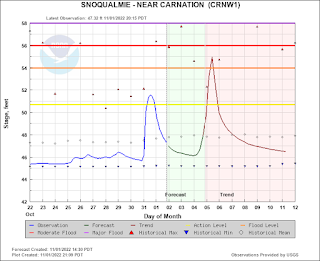
The heavy rain should raise river levels substantially, with the Snoqualmie River reaching flood stage (see the forecast for the Snoqualmie River at Carnation provided by the NOAA/NWS River Forecast Center in Portland)/

And then there will be wind. Take a look at the predicted winds for 2 AM Friday morning (below): southerly gusts over 40 knots over much of the region's waterways and 20-30 knots over land. As the first major blow of the fall, you can expect power outages.
I suspect you want to know about the potential for snow next week.
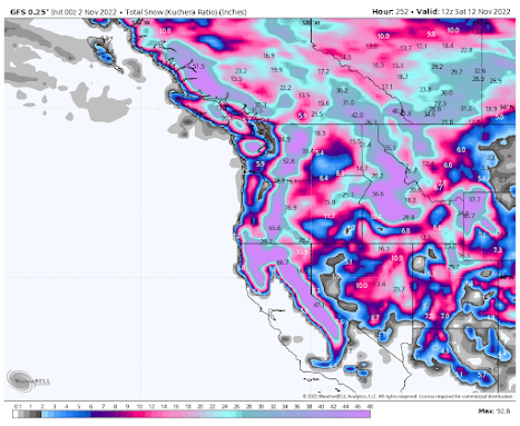
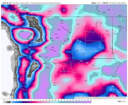
The predicted snow total through next Saturday (November 12) by the US GFS model shows massive snowfall over mountains of the entire West.

And yes, some snow over the lowlands of western Washington. Much of this snow falls on Sunday through Tuesday. I will examine the snow and cold in much greater detail in my next blog.

________________________________________
A very interesting and intriguing book on dealing with environmental issues has just come out: Time to Think Small: How Nimble Environmental Technologies Can Solve the Planet's Biggest Problems by Todd Myers. Amazon link here.
Mr. Myers discusses how diverse, distributed actions (such as farming techniques that reduce CO2 concentrations in the atmosphere) can play an important role in mitigating global warming. He even has a section on my work with smartphone pressures. His main point is that local/regional actions or the application of "crowdsourced" technologies can make a big contribution to dealing with environmental issues.


Possible bonehead question: the Straights of Juan Dr Rica are showing 0 wind? Is that area shadowed by Vancouver Island?
ReplyDeletemap colors begin at 30 knots https://a.atmos.washington.edu/SCL/
DeleteI think you meant Strait of Juan de Fuca? That area will be protected by the Olympic Mountains since the winds will be coming out of the south. White appears to mean gusts under 30 mph, not zero wind.
DeleteWe in Port Angeles get wind shadowed as well in cases of Southerly winds
DeleteAbout 7:00am on 11/2/22 I saw on radar and GOES-W images of a gentle vortex center over lower Puget Sound. 4 hours later it is still there. Would you explain to me and the rest of your readers what is going on? Thanks.
ReplyDeleteCliff,
ReplyDeleteAre the integrated water vapor transport values in the graphic calculated for pressure levels from 300hPa-1000hPa? My understanding of ARs is that the moisture they conduct moves predominantly through the higher pressure levels of the atmosphere (~600hPa-1000hPa). Is this an accurate interpretation? If so, it would seem as though a sufficiently high altitude land surface, say, the summit of Mount Rainier, would largely be above an AR. Could the plume of an AR streaming directly at Rainier from the west carry deep enough moisture in warm enough air to ever result in liquid precipitation at the summit? If the moisture was deep enough would orographic uplift produce in enough cooling to result in frozen precipitation? I'm curious if there is a plausible atmospheric setup that might result in rain on the summit of Rainier and if an AR might be such scenario.
I'm sorry, but the Washington Policy Canter is not who we should look to for the major problems of our planet. I think it's going to take incredibly large actions to save us from ourselves.
ReplyDeletehttps://www.washingtonpolicy.org/authors/detail/todd-myers