October 31, 2022

Record-Breaking Cold and Snow is Forecast by the Models. Can It Really Be True?

I have to tell you about this, even though some of the forecasts are crazy extreme.

For several forecast cycles, the models have suggested that later this weekend and next week record-breaking cold and snow hit the region.  

Yes, lowland snow.  

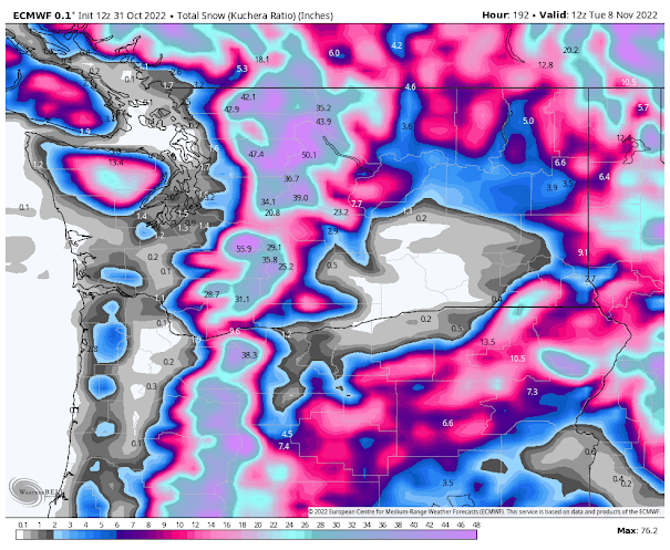
Let's start with the vaunted European Center model.  The totals for the next week (through Tuesday morning) are shown below.    A dusting over the lowlands and massive amounts (2-4 ft) in the mountains.


The American GFS model is similar with large mountain snows, but it also had a band of 1/2 feet over the south Sound.


And the U.S. GFS has even more lowland snow through Thursday.  Furthermore, the totals through mid-November are sheer madness, with nearly 2 feet over Seattle.  The American model has problems.


The accumulated snow over the next week by the UW model is also substantial over the mountains and has some lowland snow over western Washington.   Folks....we may be skiing by Thanksgiving.


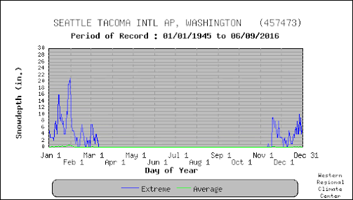
As shown by the climatological snow graph below, getting any kind of lowland snow during the first two weeks of November is basically unprecedented.


Anyway, thought you should know.   I will keep watch on these forecasts since there is a lot of uncertainty for such extended predictions.

What you can depend upon are cooler-than-normal temperatures (including highs only getting up into the mid-40s) the next few days in the lowlands and bountiful mountain snow.

The origin?   A strong trough of low pressure along the coast (see upper-level --500 hPa pressure--map for tomorrow morning), with the blue and purple colors showing much lower than normal heights (or pressures) aloft.


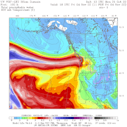
And we are confident that a powerful atmospheric river will bring a plume of moisture to the coast on Friday, resulting in substantial rain and mountain snow (see the forecast of total atmospheric water vapor for Friday, below)


So don't worry about wildfires, drought, or lack of snowpack---we are now entering a period of massively cold, wet weather.   The yin and yang of the weather is quite evident.


October 29, 2022

Bizarre Clouds Seen Over Puget Sound, Plus My Latest Podcast/Forecast

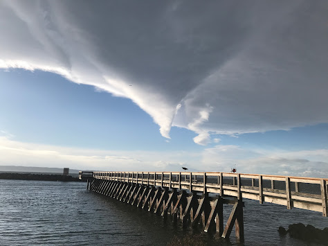
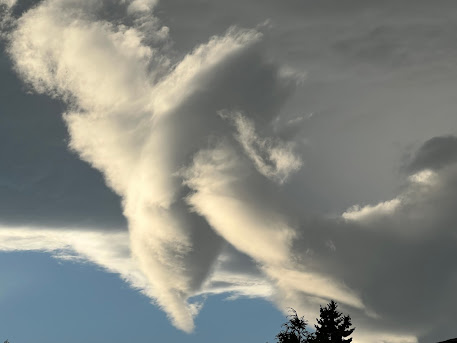
 During the past day, I have received several emails and pictures of a strange cloud feature seen from roughly 4 PM to 5:30 PM on Thursday.  Let me show you.

Theresa Verway took this picture from Shilshoe Beach in Seattle around 4:12 PM 


Steve Moseley took this picture in N. Seattle around 5:18 PM


And here are two views from the Seattle PanoCan, one around 4 PM and the other around 5:30 PM.  Note the blue skies nearby....that will be important.


So what caused these strange clouds?    

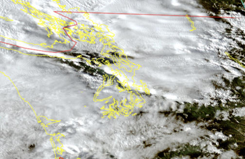
To gain some insight, let's take a look at high-resolution satellite imagery at the same time.....that should provide some major hints!

Here is a high-resolution visible image at 4:30 PM.  For a trained meteorologist the imagery suggests a high-amplitude mountain wave forced by the Olympics.


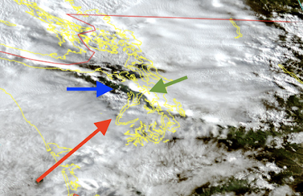
Let me explain, using a marked-up version of the image below.  On Thursday, there were strong southwesterly winds (from the southwest) approaching the Olympics--see red arrow.  As the air rose on the western side of the Olympics, clouds (and precipitation) were enhanced.   

But as the air moved down the northeast side of the Olympics it descended, drying the air and producing a clear zone (see blue arrow).  

The movement of the air up and over the Olympics established a mountain wave pattern and the air subsequently rose rapidly downstream, forcing an impressive area of clouds (green arrow).  


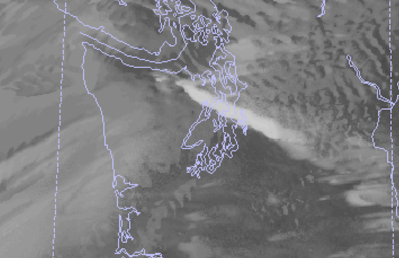
This high-amplitude mountain wave pattern can be simulated by our best forecast models, such as the UW WRF modeling system.  In fact, our model predicted this interesting cloud (see below)


Such high-resolution mountain wave clouds can have very complex structures in three dimensions, and that was certainly the case on Thursday afternoon.  So complex that some folks have mistaken these clouds for UFOs--unidentified flying objects.


My podcast today will be about the interesting forecast for this week--lots of weather action and mountain snows ahead!.
___________

To listen to my podcast, use the link below or access it through your favorite podcast service.


Some major podcast servers:

 HTML tutorial HTML tutorial
Like the podcast? Support on Patreon 


October 27, 2022

A Cold, Wet Month Ahead and Maybe More of the Same Through Midwinter

 If you enjoy cold, cloudy, wet weather, with plenty of snow in the mountains, you will love the next month.

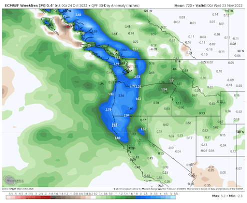
The latest extended forecast from the most skillful global prediction system in the world (the European Center) is going for much wetter than normal conditions for most of the western U.S., with MUCH wetter than normal conditions west of the Cascade crest.  Good to see California getting a piece of this!


And temperatures over the western U.S. during the next 30 days will be colder than normal (see below).

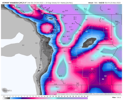
Cold and wet can only mean one thing:  lots of snow.  Below is the predicted total for the same period.  

Skiing by Thanksgiving at Whistler, Baker, and Crystal Mountain?  It is possible.


What about the long term?  

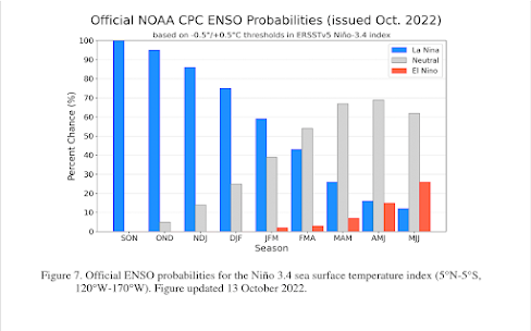
La Nina conditions--which bring colder and wetter than normal conditions to our region, particularly after the New Year-- have strengthened and the NOAA Climate Prediction Center keeps La Nina around into mid-winter (see below). 


In short, after a cold, wet spring and a dry, warm summer/early fall, a cold/wet start of the winter season looks probable.  

Good news for replenishing our reservoirs and establishing an early snowpack.


October 25, 2022

Annual Precipitation is Close to Normal While Flood Warnings are Out in Western Washington

 Today we have a very vigorous front passage, with a very intense cold front.   

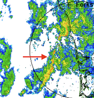
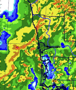
For example, here is an image from the Langley Hill radar (near Hoquiam) at 5 PM.  The arrow points to an intense narrow cold frontal rainband, with red colors indicating torrential rain!  Such intense fronts break down into wave-like undulations.


Amazingly, high-resolution weather prediction models were able to predict this feature but were a bit too fast (see the forecast for 3 PM).  Weather models have come a long way.


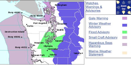
The National Weather Service was so worried about this cold front that they put out a flash flood warning for the south Sound area (see below)


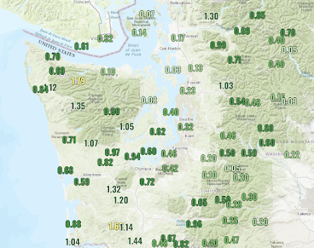
The rainfall over the past 24 has been substantial, with some locations getting over an inch.  

The wildfire season in western Washington is now over.

And yes, there is a lot more to come over the next week.

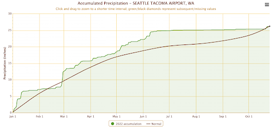
Interestingly, our rainfall for the year is almost exactly normal now in western Washington.

Here is the cumulative precipitation plot since January 1 at Sea-Tac, with the green line showing this year's total and the brown line showing climatological values.  The wet spring balanced the dry summer/early fall.


Same with Hoquiam

Interestingly, the eastern slopes are well above normal; (see Wenatchee below).    Not only was the spring wet, but they had normal summer precipitation.

Further cooling is predicted for next week, with several days not getting above the high 40s. Really a stunning change from a week ago


October 23, 2022

The Atmospheric Spigot is On and Will Stay On

 The rain over the past few days is just a taste of what is in store for us this week.

And by the end of the next few days, the annual precipitation for many Northwest locations will actually be above normal, even after the dry summer and early fall.

Tonight, another wet system is approaching (see the latest radar image below)

A view of the latest infrared satellite imagery shows that one system after another is lined up to move into our region (see below).

The latest European Center forecast for accumulated precipitation for the next 10 days is stunningly wet, with over ten inches on the western slopes of some of our regional terrain (see below).

The wildfires will be history--that is pretty much guaranteed--and the streamflow will zoom upward, which is good for fish migration up rivers.   Reservoirs and dams will begin to refill.

You can turn off your sprinkler systems.

The UW forecast system shows a similar picture, with the total precipitation over the next 7 days reaching up to 10 inches in certain exposed terrain, particularly in BC.


I haven't talked about snow in a long time.   Time to do so.  

Here is the UW model's forecast snow totals for the next week.  Wow.  Several feet in the Cascades and much more over southern BC.


The media and others can move on now from the incessant stories of smoke, wildfires, and drought, to the topics of flooding and atmospheric rivers.


October 21, 2022

Was Global Warming Behind the Recent Smoky Period in Western Washington?

Some media outlets and activists have been making big claims that the recent westside wildfires and resultant smoke were the result of global warming (also known as "climate change").  


This is simply not true and this blog will provide the evidence.  You decide.

Imagine if you were a journalist assigned to write a story on the potential connection between global warming and westside wildfires.   You would certainly want to ask these questions:

1.   Is the area burned west of the Cascade crest increasing over time?   If global warming was the cause one would expect a trend towards more westside wildfires over the past few decades when warming has been greatest.

2.   Are the meteorological factors associated with westside fires trending up over the past decades?   Furthermore, do climate model projections indicate increases over time in these key parameters?    

In the case of westside fires, the key parameter is strong easterly (from the east) winds.   All major westside fires are associated with such winds.   Another (secondary) factor is a dry late summer and autumn, the season of virtually all westside fires.

The Yacolt Burn in 1902 was the most extensive westside fire during the past 120 years.

Responsible journalists and climate activists should be asking and answering these questions.  And it turns out that the best answers to these questions indicate strongly that global warming is not and will not enhance such westside wildfire events.

Let's look at the facts.  

Is there a trend in westside wildfires?

Below is a plot of the burned acreage west of the Cascade crest in Washington.  There were BIG fires early in the 20th century (Yacolt, 1902; Dole Valley, 1929).   Then there was virtually nothing until the much smaller 1951 Olympic Peninsula Fire.  Then another fire "drought" until another small fire in the Olympics (the 2015 Paradise fire),  followed the modest fires of this year.

Do you see evidence of a trend towards more westside fires in Washington?     I don't.  And that alone is enough to deflate any claims of greenhouse warming revving up westside fires.

The Essential Meteorological Requirments for Westside Fires

Westside forests are generally not prone to large fires.   The reasons are evident: these are relatively moist environments, experiencing huge precipitation totals on the windward slopes during the cool season.  They are characterized by a green, moist canopy.    

The period from June to September has little rain in a normal year and there is a slow drying of the surface during the summer, as well as the melting of the snowpack at middle and higher elevations. During the summer there is that generally onshore flow from off the Pacific that keeps temperatures moderate and the air relatively moist.  An inhospitable environment for westside fire.

During most of the summer and fall, the air flooding western Washington is cool and moist.

As long as the flow is westerly (from the west) there is little chance of major westside wildfires. Thus, the ESSENTIAL ingredient for westside fires is to have STRONG easterly winds.

Repeat that statement 3 times.  It is that important.

Easterly winds encourage western wildfires in several ways. First, it replaces the cool, moist ocean air with very dry, warm air from east of the Cascade crest.   Relative humidities can decline from 50-80% to under 10%.  Dry conditions are good for fire, helping to rapidly dry surface fuels--which makes them much more flammable.

Second, as the easterly flow descends the western slopes of the Cascades it is warmed by compression, driving humidity even lower.  Very warm, dry air on the slopes enhances fire potential.

Third, strong winds can provide more oxygen to fires (which they need) and can blow hot embers ahead of the fires, enabling them to spread more quickly.

Fourth, strong easterly winds can START fires, such as by downing powerlines or pushing branches onto powerlines.

I have a National Science Foundation project to look at westside wildfires in Washington and northern Oregon and I (and my students) have studied EVERY large westside fire.   EVERY ONE OF THEM was associated with strong easterly winds.

With this key knowledge in mind, what will global warming do to strong easterly winds in our region?

The answer: global warming (a.k.a. climate change) will WEAKEN the easterly winds, working AGAINST more fires.

To reach this conclusion, we have applied an ensemble of many regional, high-resolution climate simulations.   As illustrated by the figure below (which is from a peer-reviewed paper), increasing greenhouse gases (like CO2) result in weaker easterly winds (in this case near the crest of the central Washington Cascades).
Number of days with strong easterly winds from 1970 to 2100, based on high-resolution climate model projections

The reduction of strong easterly winds with global warming makes total sense physically. 

Global warming preferentially warms the interior of the continent compared to the slow-to-warm coastal zone.    Warming contributes to preferential pressure declines over the interior.   Strong easterly flow is associated with higher pressure over the interior compared to the coast, and thus the preferential warming in the interior WEAKENS the easterly flow.

So the best science, from modeling to physical reasoning, indicates that wildfire-driving easterly flow WEAKENS under climate change.  The opposite of the suggestions in the Seattle Times and elsewhere.


Are Autumns Getting Drier?

    Although easterly winds are the critical requirement for westside wildfires, dry conditions are clearly helpful.  Westside wildfires have occurred during periods of normal precipitation when the easterly flow was sufficiently strong and sustained, but prior dry conditions shorten the period required to dry the surface fuels.    This year was extraordinarily dry--the driest summer/early fall on record-- and this allowed the strong easterly winds of last week to quickly enhance preexisting fires and initiate new ones.

 So let's get to the essential question:  is late summer/early fall precipitation declining on the western slopes of the Cascades and in western Washington in general? 

The answer is NO.  

Here is a plot of August to October precipitation for the last century for the western slopes of the Cascades (and eastern slopes of the Olympics) taken from NOAA Climate Division dataset.  There is no long-term drying--if anything precipitation is going up a bit.  Plotting other areas or individual stations in western Washington produces the same upward trend.


What do climate models project for the future of autumn precipitation as the Earth warms?  As shown below, an INCREASE in precipitation.


The Bottom Line

In contrast to the claims of the Seattle Times and some activist types, there is no reason to expect future increases in the size or frequencies of westside wildfires.  There is no observed upward trend in wildfire acreage west of the Cascade crest.  Global warming should weaken strong easterly flow, the key meteorological factor associated with autumn westside wildfires.   Furthermore, there is no evidence for decreased autumn precipitation over the region and climate models suggest that such precipitation should, in fact, increase.

____________

To listen to my podcast, use the link below or access it through your favorite podcast service.


Some major podcast servers:

 HTML tutorial HTML tutorial
Like the podcast? Support on Patreon 


It's Over.

 Just a short note.

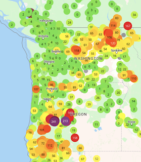
Last night, as marine air surged in, there was a rapid improvement in air quality around the region.  The latest purple air map shows that all of western Washington now has good air quality.   With strengthening onshore/westerly flow the wildfire smoke has been pushed into northeast Washington.


Expect improvements in the central and southern Willamette Valley later today.

A series of distrubances in northwesterly flow will bring precipitation to the regon during the next few days, with the mountains getting the bulk of it.   Check out the accumulated precipitation amounts through 5 PM Monday (see below).   Several inches will fall on the western slopes of the Cascades, which will greatly diminish current fires.   Temperatures will plummet and relative humidities will be high.

Due to the incoming wind direction, Puget Sound will be rainshadowed by the Olympics, and a profound rainshadow will occur east of the Cascades.


In short, we have gone through the transition to more winter-like conditions.

And we are not going back.  

Below are the totals during the next ten days.  Wow.   I will get my umbrella out!


Tomorrow's Windstorm in Four Acts

 Each atmospheric "play" is different and according to high-resolution forecast models, I can describe the four "acts" t...