Well, it appears it will also be most smoky before the rain.
This weekend is going to bring a mix of record-breaking temperatures and smoky air....a situation that will probably be more unpleasant than today.
The visible satellite image this morning around 9 AM showed a lot of smoke heading into northwest Washington

And later in the day (5 PM shown) air quality over much of western Washington, and particularly Puget Sound, was marginal (red colors). I noted the odor of fire at the UW this afternoon.
Temperatures climbed into the mid-70s around western WA, with even higher temperatures in the foothills of the Cascades and Olympics (from warming downslope flow).

But the situation is going to get warmer and smokier this weekend.
With high pressure building to the east and a trough of low pressure extending up the West Coast, a moderate offshore pressure difference (higher inland, lower coast) will result in easterly (offshore-directed) winds. This easterly flow will warm further on the western side of the Cascades and coastal mountains.
.gif)
This situation has its dangers.
On Saturday, as warm, gusty easterly flow surges westward, the dry winds will be particularly strong near the Columbia Gorge, something illustrated by this graphic showing the HOT-DRY-WINDY index.
We will all have to be careful not to start wildfires over northwest Oregon and southwest Washington.

The warm, dry air will spread over western Washington on Saturday with increased winds on the western slopes of the Cascades. The current fires (e.g., Bolt Creek) will rev up with more smoke.
High temperatures will hit 80F at many locations around western Washington--about 20F above normal.
And smoke will be wafted first eastward and then westward, reducing air quality.
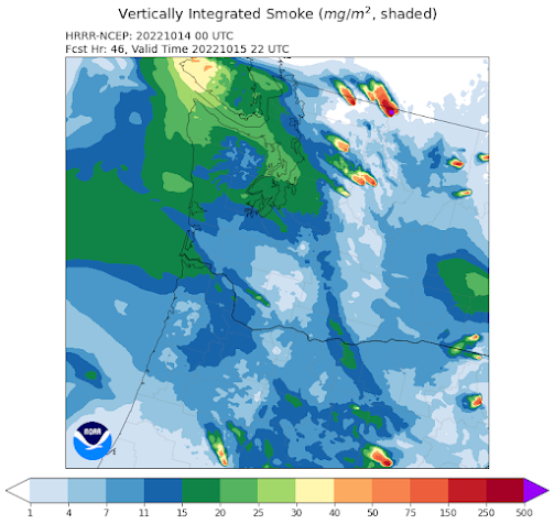
To illustrate, let me show you the forecasts from the NOAA HRRR smoke model. Starting with the total smoke in the vertical, at 5 AM Friday smoke will first pour into eastern Washington and Oregon.
And smoke will be wafted first eastward and then westward, reducing air quality.
To illustrate, let me show you the forecasts from the NOAA HRRR smoke model. Starting with the total smoke in the vertical, at 5 AM Friday smoke will first pour into eastern Washington and Oregon.

But by 11 PM Friday the smoke will push toward southwest WA and northwest Oregon and begin pushing westward across the Washington Cascades.

And then on Saturday morning, the smoke will surge into western Washington.

Much of the smoke will be aloft, producing a red sun, but some of it will reach the surface, as illustrated by the predicted surface smoke at 3 PM Saturday.
I may skip running that day.

But the dawn is coming, and the latest forecast indicates a radical change to cool, wet weather the next weekend.
_______________
Announcement: I will be doing a special online (zoom) session with my Patreon supporters at 10 AM Saturday. I will discuss the extended forecast and answer your questions.


The models are trending drier every day.It's looking like the rains predicted for the next weekend may only be a short respite.The GFS( for what it's worth) is even showing 500 MB heights in the 570s-580s around the 29th!
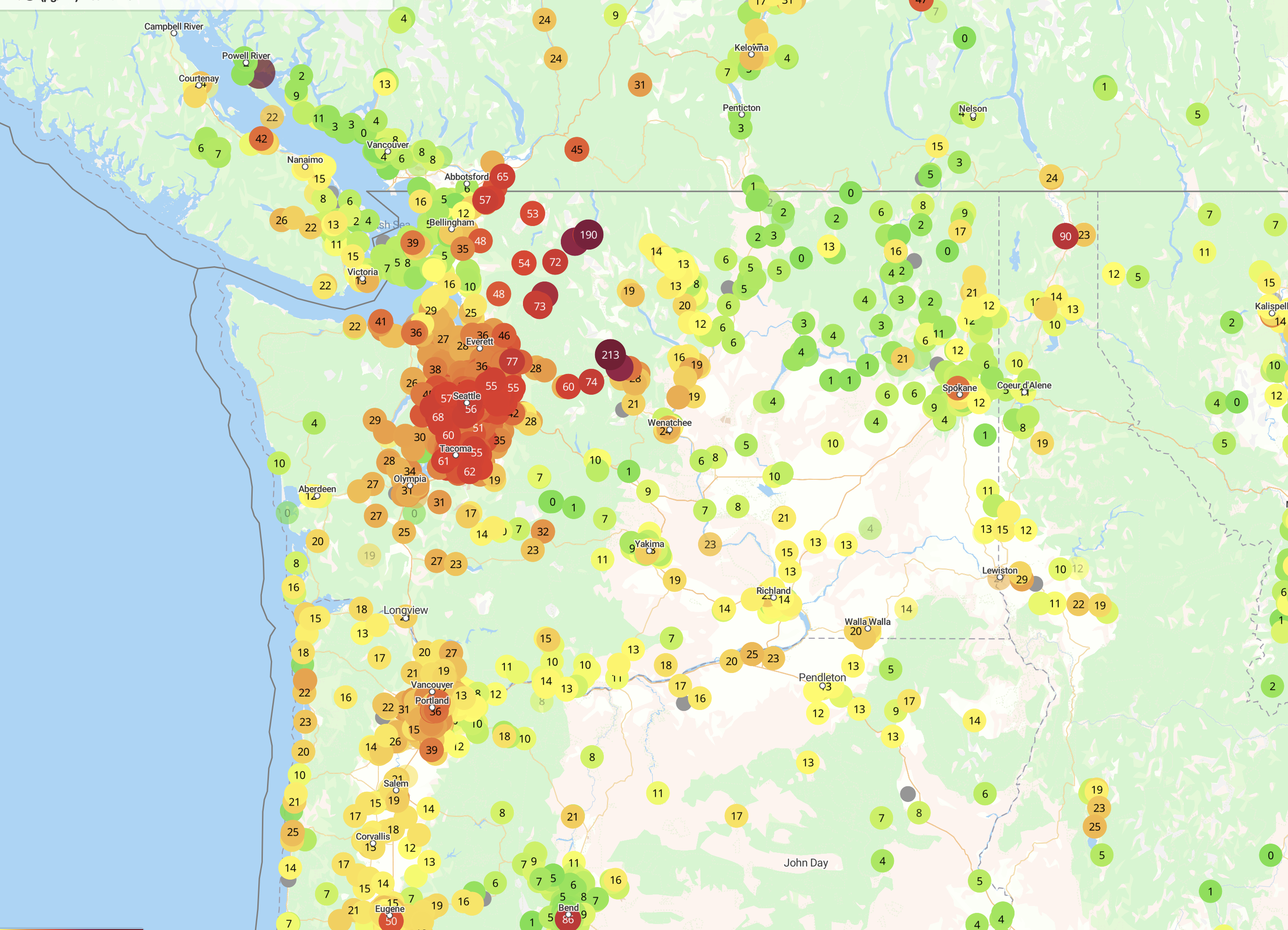
ReplyDeleteIs there a direct relationship between "vertically integrated smoke" reported on the forecasts you shared and "air quality index" reported on sites like Ecology's Air Monitoring Network (https://enviwa.ecology.wa.gov/home/map) and Purple Air?
ReplyDelete😭
ReplyDeleteHi Cliff, if I were to try to avoid smoke this weekend is there anywhere drivable that the smoke forecast is not so bad, Walla Walla? Vancouver BC? Is there a good weather site that actually forecasts the smoke by area? I have not found one. Thanks
ReplyDeleteI don't know how accurate it is, but, https://wasmoke.blogspot.com/ has a forcast map that shows smoke for Washington three days out
DeleteCliff -
ReplyDeleteYou recently told a commenter to read another weather blog if they disagreed with yours. In keeping with that mentality the Times would respond to your post below by telling you to read another newspaper.
For the record could you state somewhere on your website that you don't also censor posts based on your personal views on climate change. Also posting this comment rather than censoring it would prove that. If you can't post it you have no place finding fault with the Seattle Times.
I'm hoping this doesn't need to be aired out on social media. I have no reason to have your status with the public reduced, but, if you are censoring comments folks should know the Comments section is not a place where discussion of important matters can occur.
thanks
Have You Been Censored by the Seattle Times?
I have become aware of a serious problem at the Seattle Times: they have been censoring people who have left comments with a different viewpoint on climate change than theirs, with their actions based on accusations of "climate misinformation." If you have been censored by the Seattle Times, including removal of comments or locking of accounts, please let me know through email or as a comment on this blog (I will not reveal your identity).
This is a very serious issue and reflects a disturbing attitude at our local newspaper.
John.... you are not correct, I am afraid. First, I never censor folks based on their viewpoints on climate change. Second, there is only one newspaper in Seattle and hopefully that paper will attempt to provide accurate, unbiased information in their news sections. Unfortunately, that has not been so. Finally, there are many blogs available and even many Seattle weather blogs. If someone doesn't like my blog, there are many alternatives. That is my point...cliff
Delete