I was worried that this could happen.....
Powerful easterly (from the east) winds developed yesterday and this morning.
As they descended the western slopes of the Cascades, the air warmed and dried.
As a result, preexisting fires revved up (e.g., the Bolt Creek Fire near Skykomish, the Suiattle Fire near Arlington) and some potent new fires were initiated (the Loch Katrine fire east of Duvall and the Nakia Creek fire northeast of Vancouver, WA).
The latest visible satellite image shows these fires (red arrow for Nakia Creek and blue arrow for the Loch Katrine fires).


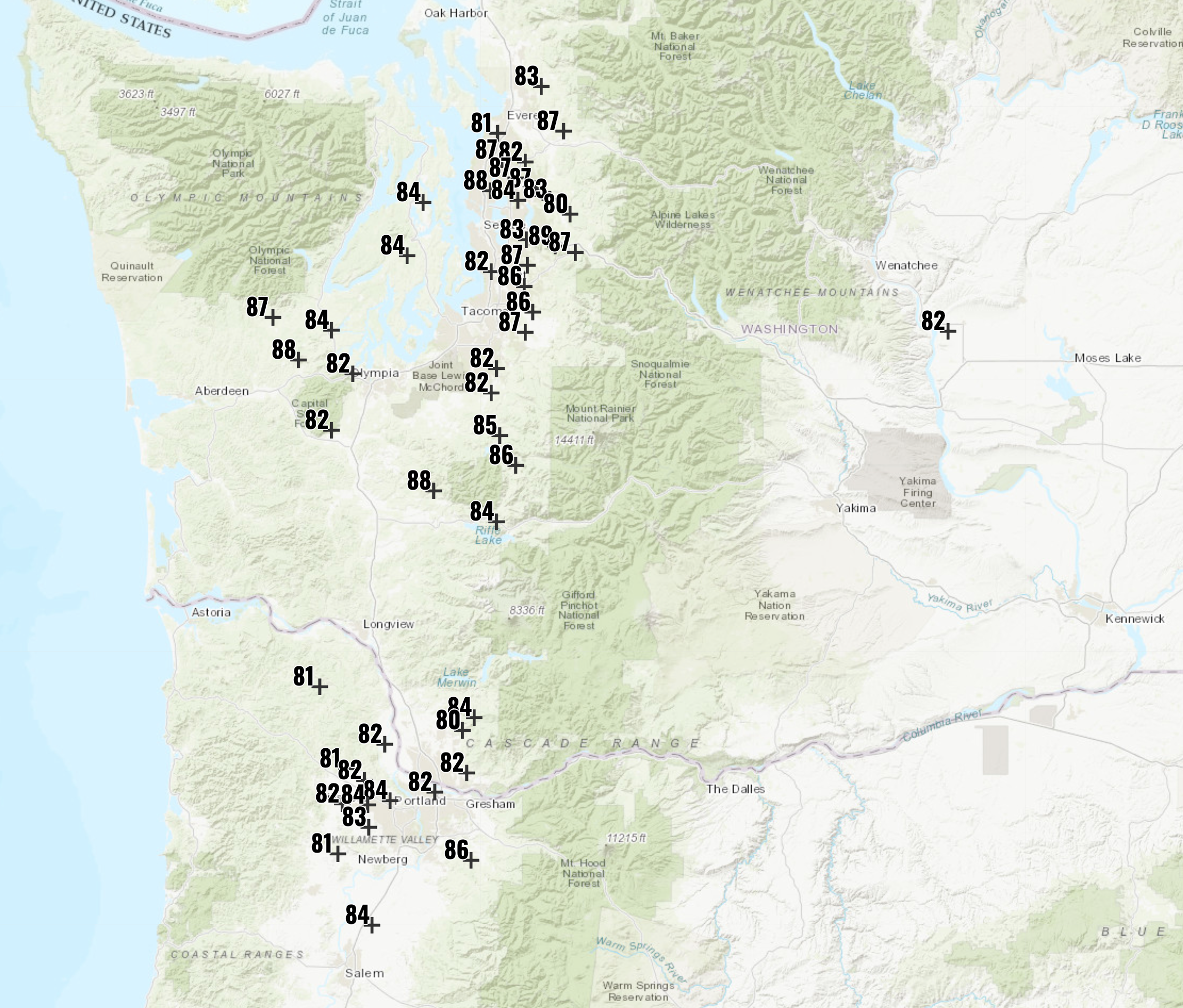
Temperature is a different story. Where the warm, dry, subsiding air above mixes to the surface, temperatures have become crazy hot.
At 1 PM, a number of locations in our region (mainly just west of the Cascades) are in the 80s, with some IN THE UPPER 80S. (map at 1 PM below) A few "lucky" locations will get to 90s this afternoon.


At 1:40pm it's 88 here on the Enumclaw Plateau. The tomatoes are lovin' it! In October!
ReplyDeleteNWS was forecasting 77 for the high in SeaTac. I hit 86.5 at 2 PM. Humidity is at 23%.
ReplyDelete89 degrees in Bremerton. Would it be accurate to call this a Heat Dome? Had this been actual summer and not this nonsense, where would the temp be? 115?
ReplyDeleteloch katrine started on sept. 2. not a new fire.
ReplyDeleteYesterday was definitely an interesting weather day! My weather station is located just about exactly 2 miles to the southeast of the weather station at Bellingham International Airport (BLI) and while BLI set a new daily and monthly record high temperature of 80F during a relatively brief period of downsloping Fraser outflow winds between about 2PM and 5PM, the maximum temperature at my station was only 72F. The strength and orientation of the pressure gradient was such that the outflow winds never reached my location and the day ended up being quite pleasant temperature-wise but was more or less ruined by the smoke. In other Bellingham news, BLI has now set or tied 7 daily record high temperatures this month - more than in any other month in its record which began 1/1/1949. In addition, the temperature has reached 70 or above on 11 days this month which is the greatest number of days in October during which the temperature reached this mark in BLI history - the previous record was 6, set during 1952 and tied in 2014. The temperature has reached 75 or above at BLI on 4 days this month which is the new record, having beaten the previous record of 3 days set during October 1952. This century, BLI has set or tied monthly record high temperatures in 10 out of 12 months - all except May and September - and of those 10, 7 were set or tied in just the past 10 years.
ReplyDeleteThe weather was so strange. I was backpacking in 7 Lakes Basin in the Olympics and it was between 80-85 degrees up around 5k+ ft. I got reception at some point and saw Port Angeles was 10 degrees cooler. Is this because PA is closer to the water? Or was there some sort of temperature inversion?
ReplyDeleteYes, Port Angeles is right next to a big ice bath called the Strait of Juan de Fuca. I have seen this sort of thing. In a stiff breeze I needed to wear 4 layers while sailing across it on August 1 some years back. It can easily be warmer a mile up during an inversion like this.
DeleteA new resource for fire maps is this site https://wfca.com/fire-map . It will show fire growth maps, and includes a 3-D mode (button upper right corner of map) that allows you to see the a 3-D terrain map.
ReplyDeleteA mapping resource only with basic details about the fire spread and control. Interesting to see all of the fires in the area.
A part of me wishes I could go drive up FS 6024 or FS 6510/6514 on Friday to watch up close as the rain finally puts this persistent, smouldering mess out of our misery. Understandably, those roads are closed and will no doubt remain that way until not only the fire is out, but the Forest Service also has time to inspect for tree and mudslide hazards.
ReplyDeleteIt's not actually unusual for this time of year, but after all this heat and dryness, it was startling to see the forecast for the higher elevations includes SNOW! The 10 day forecast is for potentially several feet of it. US-2 might be closed yet again, but this time at Stevens Pass instead of Index.
I was backpacking in the Vesper Peak area this past weekend. The air cleared at night, and tended to get smokier during the day both Saturday and Sunday. Since the atmosphere cools from the ground up, I guess that keeps the smoke near the ground.
ReplyDeleteTwo new fires! I wonder how the Loch Katrine fire started? No lightning, so what else than a careless camper? I have never been more ready for rain. Bring it on!
Per InciWeb, the cause is still listed as undetermined, but the fire actually started on September 2. It's very possible that it's a lightning holdover. It's not uncommon for a lightning strike fire to smolder undetected for weeks until either hot, dry winds wake it up, or heavy rains put it out.
DeleteCliff, it looks like the winds tomorrow afternoon may be favorable to start pushing smoke east again. Does that sound right? Love your blog and podcast!
ReplyDelete