Yesterday (Sunday), was one of the most extreme high-temperature days in western Washington history.
In some ways, almost the equal of the June 2021 heatwave.
Consider a map of the high temperatures on Sunday (below, click on image to expand). 88F at Sea Tac and lower 90s in some locations.
Amazing for mid-October.

As noted in my previous blogs, this heat was associated with strong easterly (from the east) winds that warmed by compression as they descended into western Washington.
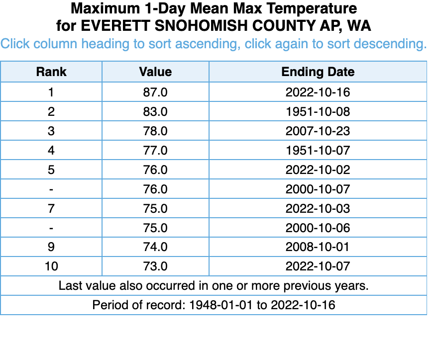
Now let me convince you how unusual this was. Consider Paine Field in Everett. At this station, the temperature reached 87F--the warmest October day on record at that location. The runner-up was 4F cooler. SeaTac had its second warmest day on record, with the warmest day being on October 1.
 |
| October Records |
During the June 2021 heatwave...the greatest in Northwest history... SeaTac Airport jumped to 108F, 17F above the previous record high for the date. On Sunday, SeaTac hit 88F, 16F above the previous record for the date.
At Everett, the high of 87F on Sunday was 29F above the typical high for that date, while on June 28th, the 100F temperature was 31F above the normal high.
The bottom line: yesterday was extreme and rare.
Smoke Protection
Today, a lot of smoke was blowing overhead but air quality was decent at low levels.
Why?
To show the smoke, here is a visible satellite image around noon. It looked like something out of Dante's Inferno! Later satellite imagery looked similar.

But the air quality map around 6 7 PM showed decent air quality around Puget Sound, with the worst conditions around Olympia (expected due to numerous smoke-filled rooms).

It turns out the something was protecting us living at lower elevations, preventing the smoke from mixing to the surface.
The name of our friend? The Inversion.
Inversions occur then the temperature warms with elevation. Inversions suppress mixing.
Why did we have an inversion? Because cool marine air at low levels moved in overnight, while warm air remained aloft.
That produces an inversion.
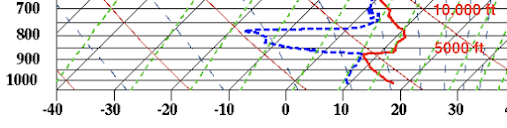
Here is a plot of temperature (red line) and dew point (blue dashed) from the launch of the balloon-lofted weather station (radiosonde) at Forks on the WA coast around 5 PM this afternoon. Around 5000 ft the temperature increases with height. That is the inversion!
The inversion should weaken but remain in place on Tuesday so I expect our air to remain breathable. But air quality will slowly degrade over time until Friday, followed by rapid improvement as rain and wind move in.
For Seattle, the biggest problem is the Loch Katrine fire, which is low and close, providing less "inversion protection."


If this was indeed nearly as extreme as the 2021 event - though I think it's better to use the climatological normal maximum for the date rather than all time maximum - wouldn't that be 2 100+ year events in two years? And perhaps that's a sign of ... climate change?
ReplyDeleteGiven that 8 of the last 10 heat records in October have all been since 2000 or later should tell us something...
DeleteThe climate is changing all the time. But either way I'm not sure a couple extreme data points within a 100 year time frame are enough to indicate any particular "new trends".
DeleteAdd the extremes to well above average temps. the last four months, well below average rainfall the last five months, and multiple record temperatures shattered this summer/fall and there appears to be a trend.
DeleteWhat would then!? Also... Define "trend".. does statistics not make it past quotation marks??
DeleteWhat was up with the weather, back in 1951?...so warm in October, and then there was record snowfall during the coming winter...I can vaguely remember this event!...We truly live in an area where weather can be capricious...So, does our current situation portent a super-cold, snowy winter?...probably not.
ReplyDeleteIt was 1952,not 1951.Btw,that November was extremely dry,followed by a snowless,El Nino winter.
DeleteMy recording thermometer showed 82 degrees on the Bothell-Mill Creek line. on Sunday for the high. I think it may read about 2 degrees low, but even at 84, all the official readings in the area were higher... But it does seem that we have had a run of longer, drier summers in recent years. In the 70's, when I moved here, the third week of August always seemed to be rainy...
ReplyDeleteYou are correct! I've been keeping records since 2011 for monthly and annual precipitation in Olympia, using the data reported in the State Climatologist newsletter. July/August precipitation has been below average for 6 of the last 12 years (2016, 2017, 2018, 2020, 2021, and this year).
DeleteSmoke-filled rooms in Olympia... A swipe at the politicians? Ha ha!
ReplyDeleteI think the example of the inversion ameliorating our air quality woes with the map of AQI values following the marine push is cherry-picked. My experience is that temperature inversions generally never result in improved air quality. Whatcom County has been under an Air Quality Alert continuously since last week and the first ~3 weeks of this month have been generally characterized by a persistent temperature inversion. I have an air quality sensor at my house in Bellingham and my observation has been that air quality is usually best in the late afternoon to early evening after the surface has warmed sufficiently to generate convection which results in mixing of the atmosphere and that air quality is worst in mid to late morning after the atmosphere has stratified overnight and the inversion reestablished trapping smoke near the surface. If there were less daytime heating to generate the convection-induced mixing of the anomalously warm air above the inversion layer then this might not be the case as smoke would remain trapped above it. However, this has been either the warmest or second warmest (after 1987) start to October in Western Washington history depending on location precisely because, despite the presence of the inversion, daily high temperatures have been particularly anomalously warm especially compared to daily low temperatures. Take, for example, Olympia Regional Airport (OLM), where the monthly mean temperature is 6.3 degrees above normal. This is due almost entirely to the exceptionally warm daily high temperatures which have averaged 11.9 degrees above normal while the daily low temperatures have averaged a mere 0.8 degrees above normal. The story is similar at Bellingham International Airport (BLI). This is indicative that the stratification of the atmosphere/temperature inversion, with warmer air aloft and cooler air at the surface has been consistently disrupted through some process - most likely convection-induced mixing due to heating of the surface during the day. I think most would agree that the air quality has generally not been good this month and the data bears out that sentiment. The presence of a persistent temperature inversion has more than likely exacerbated this problem rather than improving it. If the assertion that the presence of a temperature inversion resulted in better air quality, at least for a time, following the recent marine push is valid (and I'm not convinced it is) then it is an edge case and an exception to the rule.
ReplyDeleteread my recent blog. The inversion is a two edged sword. Initially it helped protect us from distant smoke, but when a close, shallow fire occurred, the smoke got trapped under the inversion. Please try to understand the nuances of this situation.
DeleteThe aspect of Sunday's heat that is actually catching my attention the most is the contrast with this coming Sunday's expected cold.
ReplyDeleteThe forecast for this weekend is pretty normal for this time of year, but it's such a stark change from near 90 degrees in the lowlands, and lower 70's at Stampede Pass this past weekend, to snow falling in the mountains this coming weekend.
Admittedly, looking at the current forecast, I'm skeptical it will snow at the pass level, but the peaks should be showing beautiful, fresh white tops if we get a clear view before the second wave of precipitation hits mid-week.
Inversion our friend, really? In the evening (as now) it traps all the smoke near the ground. Instability would be of more help. Seattle is now "very unhealthy", and Bothell is approaching that level. Darrington is "hazardous", according to Airnow.gov.
ReplyDeleteSo much for our being "protected from the fire smoke...The news today, 19th, is that our KING-SNOHOMISH county area currently has the worst air quality of any big city in the World!!...The site "Airnow" was suggesting that the smoke would be clearing out by 11am...That did not happen, and now we are being told to wait until late Friday for the smoke to go by-by...Only one thing is "clear"....smoke forecasters are faulty.
ReplyDelete