July 31, 2022

The First Serious Smoke of the Season

 You knew it wouldn't last.

This has been an extraordinarily fire-free and smoke free summer so far, but our run of smokeless skies is now ending.

A rapidly growing fire in northwest California is pushing smoke northward into Oregon and southeast Washington.

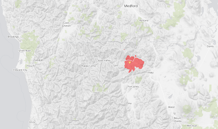
The McKinney Fire, which started on July 29 and was initially driven by strong winds,  is now over 51,000 acres and uncontained.  The map below shows its location:  due south of Medford and due east of Crescent City   Not far from I5.


Yesterday's satellite picture showed smoke from the fire pushing northward into southern Oregon.

And today, the smoke plume, thankfully aloft, has reached the Tri-cities and Walla Walla.


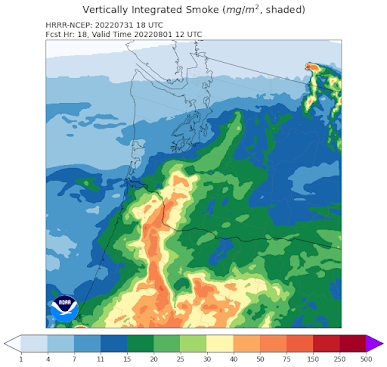
The wonderful NOAA HRRR-smoke model suggests that more smoke will move into Washington State by tomorrow morning at 5 AM (see below).  Direct hit on Portland!  This is total smoke in the vertical column.


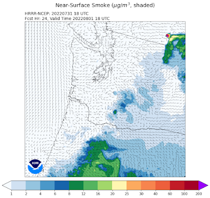
But fortunately, most of that smoke will be high aloft, as suggested by the forecast smoke concentrations at the surface at that time.


Smoke tends to loft over time, so smoke from distant fires tends to be aloft where it has little impact on surface air quality.

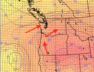
We are fortunate that the winds aloft are generally favorable to protect western Washington.  Below are the winds at 10,000 ft tomorrow morning. The winds are generally from the southwest over western Washington, bringing in cleaner ocean air.


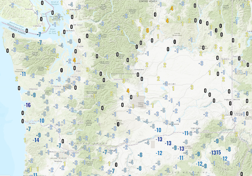
Finally, today is a bit cooler over Oregon and southern Washington and roughly the same around Seattle (see 24-h temperature change below), but tomorrow will a significant step down into the lower 80s.


No more 90s in western Washington for a while!  

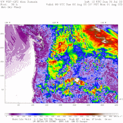
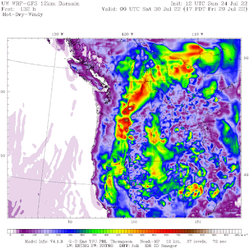
But with the cooling comes a threat.  As western WA starts to cool, strong winds will develop over the eastern slopes of the Cascades, something shown dramatically by the hot-dry-wind fire index (below).  Orange and red indicate great danger.


If you are living in eastern WA, please by very, very careful the next few days--any ignitition source could start a major fire.

July 30, 2022

The Big Cooling is Weakened and Delayed. And some amazing temperatures today.

 I hate to tell you this, but the model solutions have shifted during the past several runs:  the result is that the major cooling will be delayed for several days.  Not good.

What has changed you ask?

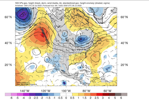
 The forecasts from a few days ago had a sharp trough of low pressure moving through on Monday, forcing cooling from off the ocean (see the upper-level (500 hPa) forecast made Wednesday afternoon for Monday at 5 AM).


But this morning's forecast for the same level and time is very different, with the trough/low hanging off northern California and a weak trough approach from the west.  This is the kind of pattern that produces a modest step down of cooling, not the large cooling we originally predicted (and hoped for).  80s not 70s.


So to update with the bad news, here are the latest NOAA/NWS National Blend of Models (NBM) predictions for Seattle and Pasco.

For Seattle, 91F tomorrow and a still warm 84 for Monday, followed by a slide down into the lower 70s by Thursday.


Pasco in the Columbia Basin will be 111 on Sunday and still over 100F on Monday and Tuesday before the cooling into the upper 80s.


This is a relatively large change in forecast so close in time--we generally do better than this.  But there were hints--strong hints--days ago--that there was considerable uncertainty about Monday's temperatures.

A potential tool is the NOAA/NWS ensemble system in which the GFS model is run many times, each slightly differently.  The prediction of this system from Wednesday after is shown below, with the high-resolution forecast (which is normally used first by forecasters) indicated by the blue line.  For the first few days, all the forecasts were on the same page, giving us confidence in the (warm) forecasts,.  But starting on Sunday the forecasts had a lot of diferences...and thus uncertainty.

We (I) need to communicate this information better.


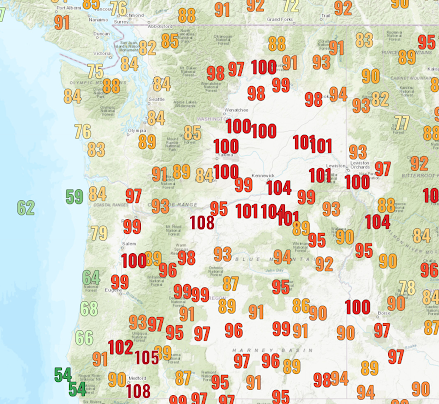
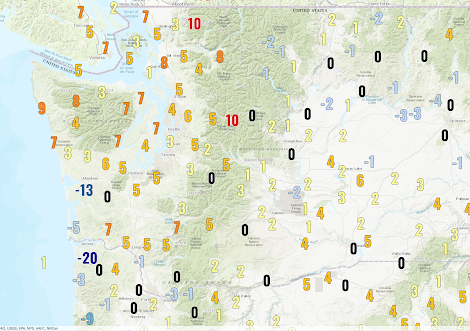
Finally, the temperatures today were pretty amazing.   Take a look at some of the high temps in Washington State (below).  Low to mid 90s around Puget Sound.  99F in Olympia and around 100F to the south of the Olympics.  Some locations on the lower wester slopes of the Cascades hit 100F and it got into the 90s in the mountains.  Hiking would have been brutal today.

Eastern WA was all above 100F, with some locations around the Tri-Cities getting to around 110.


In contrast, the lower 60s along the coast!

Oregon was even worse (see below)--around 100 in the Willamette Valley and some crazy warm temperatures of 112 and more near the Columbia River (I suspect some of these sensors).


And to make it all worse, the dew points--a prime measure of water vapor content in the atmosphere--were quite high in some locations, such as the western slopes of the Cascades where dew points hit 70F

I am heading to Puget Sound now where it show be much cooler!.

July 29, 2022

The Great Heat Wave Dilemma Explained, Plus the End of the Heat Wave in Sight.

My podcast today is all about heat waves.

Let's start with the great heat wave dilemma that is never properly explained in the media:

The Northwest is slowly warming from human-caused climate change but extreme heat waves are NOT increasing in our region.

How can that be?

First, let me prove it.

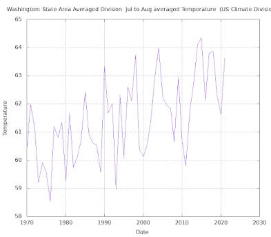
Here are the summer (July-August) temperatures over Washington State for the past fifty years.  An increase of about 2F over the period.

Some of this could be natural or the result of urbanization/instrument changes, but much of most of it could well be from human-forced climate change.  

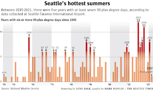
With warming over the period, the frequency of getting above some threshold like 80 or 90F is increasing.  The Seattle Times did a heat wave story a few days ago and showed this (see below from the ST).   As expected, in Seattle there are more days above 90F as we slowly warm.


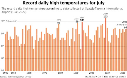
But then the Seattle Times shows a plot of record daily temperatures in July for Seattle (see below)....and there is very little upward trend!   How could this be?

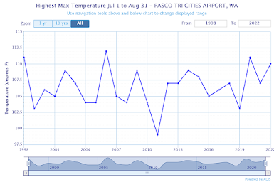
Just to check on the Seattle Times... I did the same thing for July and August over the past 50 years, plotting the warmest observed temperature at both SeaTac and  Pasco (see below). 

 Hardly any change in the extreme high temperatures each year at either site.  No long-term trend....and you would expect a trend if global warming was important for the extreme heat waves!


My podcast reveals the answer to this dilemma.   Natural variability...natural causes...dominate extreme heat waves, with global warming having only a very minor effect.   Extreme heat waves in our region can bring temperatures 30-40F above normal, and 1-2 F from global warming is in the noise level.

My podcast also talks about the big cool-down coming on Monday.  Yes, we will have to get through Saturday and Sunday, but on Monday a potent upper-level disturbance will come through and temperatures will drop into the 70s that day--with clouds and even some showers.

After that, no major heat wave is in sight!


To listen to my podcast, use the link below or access it through your favorite podcast service.


Some major podcast servers:

 HTML tutorial HTML tutorial
Like the podcast? Support on Patreon 


July 27, 2022

Humidity Storm

Yesterday on the way home from the UW, I stopped at the local supermarket to buy some food and some cold beer.

But I could hardly see into the refrigerated cases:   they were completely covered with a thick veneer of condensation.  

I mean a LOT of water (see below).


Why was there so much water vapor in the air?  

Normally, the initial stages of major heat waves are associated with downslope flow on the Cascades that is relatively dry.

Then I got a few emails from folks in northwest Washington complaining about the humidity.

OK, I had to figure out what was going on.

The best measure of the absolute amount of water vapor in the air....the "stickiness" and discomfort.. is the dew point temperature.

This is the temperature to which you have to cool air down to for saturation (100% relative humidity).  For dry air you have to cool it down a lot to get it to saturation.

So dry air has low dew point temperatures.  And moist air has high dew point temperatures.  Here in western Washington, the dew point temperatures in summer are generally in the lower 50s.  Even lower dew points are typical in dry eastern Washington.

To figure out the situation, I plotted up the dew points today around the region and was shocked (see below)

For example, the dew points around 11 AM this morning were 70F in Bellingham and around Vancouver.  And well into the 60s around Puget Sound.


These are very high dew points for our region.  The only time they were higher in recent memory was during the big heat wave last June.    Very warm temperatures can evaporate a lot of water and cause high dew points, but our temperatures today, although warm, were not even close to last summer.

The highest dew points were over the relatively cool northwest WA/Vancouver area.

 Interesting, high-resolution numerical weather prediction models, like the UW-WRF model, predicted the high dew points over NW Washington (see below for 11 AM Tuesday, light green colors indicate higher dewpoints.)


So what was the origin of this humidity storm?

First, this heat wave did not have strong flow from the east like many heat wave periods.  Such flow would be drying, with an origin east of the Cascades and lower humidity from the warmth associated with sinking air on the western slopes of that mountain range.

But then I looked at the atmospheric moisture coming off the Pacific:  a plume of very high moisture values was circling around the high pressure offshore.  This is shown by the moisture and pressures/heights near 10,000 ft on Sunday as shown below (red and grey indicated high moisture values).  You can see the moisture moving around the high on the north side.  


This moisture rotated around the high and moved into Northwest Washington (see the 10,000 ft moisture Tuesday morning, below)


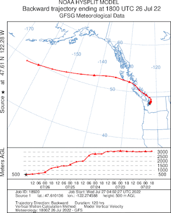
The air that reached the surface near Bellinghan and Seattle originate northwest of those cities and descended out of the moisture patch down to the surface, warming as it descended.    We can see that from the 3-D path of air reaching Seattle this morning (see below).  The top panel shows the spatial path and the bottom one shows the elevation of the air (later to the left).  The air was descending rapidly on July 24-25.


In summary, a  plume of moisture from deep over the Pacific rotated around the high and then descended to the surface.  And during the final few hours, it was over the moist western side of our region.

Well, after exploring this situation, I decided that I deserved some ice cream to help me cool off a bit.

I open my freezer....and I was stunned by what I saw....something that is associated with moist air being chilled to below freezing.    Life has its frustrations....


July 26, 2022

Heat Wave Update

Today will be the warmest day of the heat wave event in the western interior, with cooling already occurring over some coastal areas.

Yesterday's highs (shown below) ranged from over 100F east of the Cascade crest, to near 100F in the Willamette Valley, to the mid to upper 80s around Puget Sound, and to the 60s over the southern Oregon Coast.   Warmer than normal over most of the region, but few records fell.


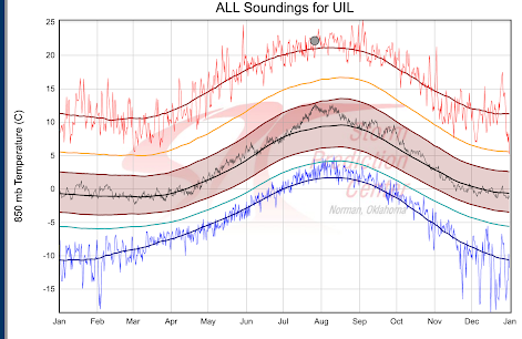
Today, the temperatures are warmer aloft...and, in fact, the temperature around 5000 ft at the radiosonde site at Quillayute (UIL), on the northern WA coast, was near record levels for the date--not all time records, daily records (see below).  (the dot shows today's temperature and the red line is the record for the date).


Today is warmer in some locations and cooler in others.  Below is the difference in temperature at noon compared to yesterday at the same time.   Warmer over Puget Sound, similar in the Willamette Valley, but cooler along the southern Washington and Oregon Coasts.


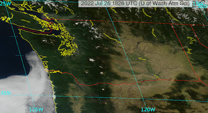
Why cooler along the coast?   Because clouds and cool air are moving up the coast, as seen in the recent satellite image.  This is forced by falling pressure in the interior.


The latest forecasts for Seattle indicate today as the warmest day, but the cooling will only be minor during the next few days.


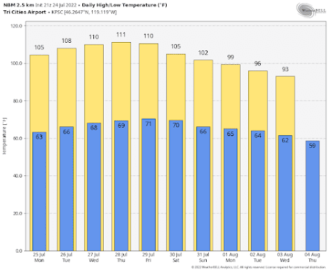
The situation in eastern Washington can only be described as torrid.  Check out the situation at Pasco in the Tri-Cities.  Scary.  Highs running to 112F on Friday.


I have studied Northwest heat waves for decades, and this is a different animal from normal.   

Why different?   Because the warmth is associated with a broad high-pressure ridge of high pressure aloft that is only slowly weakening and moving eastward.  As a result, cool marine air will very slowly move into the interior of western Oregon and Washington over the next several days.

There really won't be a rapid, energetic marine push of cool Pacific air into the west.  And this lazy influx of cool air will allow eastern WA to stay warm into early next week.

The long-term forecast suggests sustained cooling next week.

July 24, 2022

The Upcoming Heat Wave

All heat waves are not alike.   

Some are warmer than others, some are short (one day), others last as long as 5-days, some have temperatures rise and fall quickly, while others have a slow rise and rapid fall--or vice versa.  This one won't be a record-breaker, but will extend over 4 days.

We are now in the warmest time of the year (see below), so a visitation from a heat wave is not unexpected (see SeaTac temps below, the arrow is today, average max is red, record highs are yellow).

The upcoming warm period will be pretty run-of-the-mill on the west side of the Cascades, but more notable east of the Cascade crest.

Here is the latest predictions from the NOAA/NWS National Blend of Models (NBM), which combines models, observations and statistics.  NBM has done well with past heat waves!

In Seattle (below), high temperatures will rise into the upper 80s on Monday and the low 90s on Tuesday and Wednesday, slowly falling into the upper 80s on Thursday and Friday. And 80+ temperatures continue for another several days. 

A long warm period, so make a lot ice cubes and clean the blades of your window fans.

But the lows will drop into low to mid-60s each night, so cooling will be possible.


But eastern Washington will be a different story....and a hot one. Highs will climb to 110 or 111F on Wednesday through Friday, with lows dropping only to around 70F.  

That will be unpleasant.


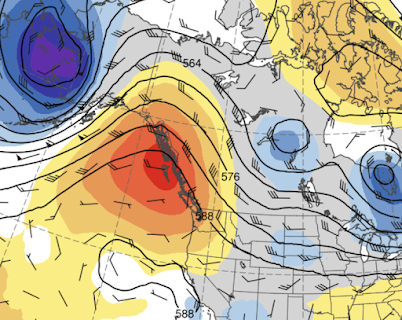
The warm weather will be associated with the building of a ridge of high pressure aloft over the eastern Pacific.  The amplitude of this high pressure (or ridge) will be a maximum on Monday evening

500 hPa heights on Monday evening.  Red is much above normal

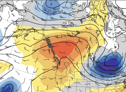
The ridge weakens a bit and moves eastward on Thursday.   This slowly changing ridge is why the heat continues so long.

Thursday afternoon

The colors are anomalies for normal in standard deviations.

There are some folks that are concerned about wildfires.   The heat in itself will not start fires, although it will contribute to drying of surface fuels.  But eastern Washington grasses are already dry enough to burn.

What is needed is ignition and wind.  Ignitions we can control (except for lightning).  But what about wind?

The big threat is at the end of the  heat wave late in the week, as cooler air moves into western Washington resulting in higher pressure there and a greater pressure difference across the Cascades.

The hot-dry-windy index that combines a measure of drying conditions and winds shows high values  (yellow and red colors) east of the Cascade crest on Friday afternoon (see below).  

We better be careful!


July 22, 2022

Potential Aurora Tonight and an Upcoming Heat Wave. All in My Latest Podcat

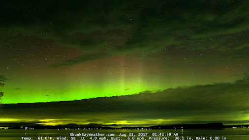
 A solar storm occurred a few days ago and the particles should reach Earth's orbit tonight.   The potential result:  a beautiful auroral display (see example below from Skunk Bay Weather on the Kitsap Peninsula).


My podcast reveals the details.  By the way, in Seattle, a good place to view the action might be the kite hill in Magnuson Park after 10:30 PM.

And then there is the future heatwave.

A potent upper-level ridge will build offshore (see upper-level, 500 hPa map for 5 PM Tuesday below) and this will result in steady warming next week.  The ridge weakens during the subsequent days but does not go anywhere fast.  

In my podcast I talk about the warming into mid-week and the potential for several days in the lower 90s in west and well above 100F in the east.


To listen to my podcast, use the link below or access it through your favorite podcast service.


Some major podcast servers:

 HTML tutorial HTML tutorial
Like the podcast? Support on Patreon 


When will the SuperInversion End?

During the past few days, a very strong inversion has formed in the lowest few thousand feet. So strong that I call it a SuperInversion. A S...