October 31, 2020

Tonight! A Rare Blue, Micro-moon on Halloween!

You knew this year was odd, in so many ways.  

Even the heavens are screaming out the message.  

And tonight, you will be able to view an extraordinarily unusual event as the moon rises around 6:17 PM PDT:   a blue moon, a hunter's moon and a micro-moon, ALL on a day signaling the supernatural:  Halloween.   Even rarer, this odd apparition will be viewable across all four time zones of the U.S.   And even more ominous, a blood-red Mars will be close to the moon.

More amazing, the skies will clear over the Northwest for a good view.

Be scared, very scared.

Let's begin with the weather situation.   It is nearly clear outside this morning around the Northwest, with very thin cirrus and some fog in local river valleys (see below).


And the latest cloud forecast from the UW WRF model indicates clear skies over the entire region at 8 PM tonight.


The full moon tonight will be a BLUE MOON, which occurs when there are two full moons in a month.  Blue moons are not that rare, occurring every 2-3 years.

But this will be Blue Moon on Halloween, which occurs roughly every 19 years.  More unusual.

But this Blue Moon will also be a micro-moon (also known as a mini-moon), in which the moon is at its farthest distance from the earth.  

The moon's orbit around the Earth is an ellipse,  not a circle, and at its farthest distance (the apogee) it looks smaller (see a comparison in size between a supermoon, where the moon is close to the earth, and a micromoon, below).

And on top of it all, this blue moon will be viewable in all time zones of the U.S., which is often not true.  

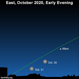
Want more?  Mars is very close to Earth and tonight will be seen just above the moon (see below).  A large blood-red Mars on Halloween.  

Image courtesy of EarthSky.org

Put all of these exceptional circumstances together, and tonight will be an astronomical treat you will not see again in your lifetime.  

And to make this even odder, nearly the entire U.S. will have clear or nearly clear skies tonight, something suggested by the latest visible satellite image from the  GOES-East weather satellite:


The full moon tonight will be a Hunter's Moon, the first full moon after the Harvest Moon, which is the full moon closest to the autumnal equinox (Sept. 21).

I will not even consider the political implications of this convergence of unusual events.

______________________________________________________________________


Stream my podcast from your favorite services:

Or you can listen to it here:

Click the play button to listen or use your favorite streaming service


October 30, 2020

New Podcast: The Election Week Forecast and Why Hurricanes Avoid the Northwest

My new podcast is out:  The Election Week Forecast and Why Hurricanes Avoid the Northwest?


Click the play button to listen or use your favorite streaming service

Episode Description

In this episode,  I give the important election week weather forecast--and I am not going to speculate on which party it will favor!   This week, Hurricane Zeta hit the Gulf Coast.  Why doesn't the West Coast get hurricanes?    You will will learn the cold truth on this podcast.

Would you like to support the podcast? 
If so, click the Patreon box below. 


Stream my podcast from your favorite services:


My blog on KNKX and the Undermining of American Freedom is found here

October 29, 2020

When is the foggiest time of the year in the Northwest?

Note: my new podcast on election week weather and why we don't get hurricanes will be online tomorrow at 7AM.
_____________________________________________

When is the foggiest time of the year in the Northwest?  

The middle of the winter when we have lots of clouds or storms, perhaps?

Or  during the summer when we have clear skies and a good opportunity for the surface to emit infrared radiation to space?

The answer is....around now.   Early to mid-autumn is our fog season.

Here is a plot of the frequency of heavy fog (visibility of less than or equal to a quarter mile) for various West Coast locations.  For Seattle, the most days with dense fog occur in September and October, with the least number of foggy days in May.  So a maximum in early fall and minimum in late spring.  Similar in Portland and Vancouver, BC.

So why is early autumn ground zero for fog?.

 Well, this time of the year has a lot going for it if you are Northwest fog.  

Most of our fog is radiation fog, which occurs on relatively cloud free nights, with the earth radiating infrared radiation to space, cooling the surface and air adjacent to the ground.  The air is cooled to the dew point, resulting in saturation and condensation of water vapor into little fog droplets.

But why is autumn so fog friendly?  Some reasons include:

  • Nights are getting much longer, leaving more time for the earth to cool off to saturation.
  • The clouds and storms have not moved in permanently, leaving periods of cloud-free conditions that allow good infrared cooling to space.
  • The rains have started again, moistening the ground and the lower atmosphere.
  • The atmosphere is relatively stable (not too mixed in the vertical) with the ground cooling but the atmosphere relatively warm.  This leads to inversions (temperature warming with height) that damp down vertical mixing, which is bad for fog.
So enjoy the fog and low clouds---this time of the year you really don't have much choice.

______________________________

Stream my podcast from your favorite services:


My blog on KNKX and the Undermining of American Freedom is found here


October 27, 2020

The Election Day Weather Forecast: Who Will it Favor?

 I got a call today from a political science professor from California:  he wanted to know how to get reliable weather forecast information for next week because weather can favor one party over another.

I helped him, but this got me thinking about the weather on election day, particularly since we are now close enough in time to have some skill.

I was familiar with a number of studies that have been done on this subject, and their suggestion that bad weather favors Republicans (see an example below).


So what do the latest and best model forecasts predict for election day?

Since my blog readers deserve the best, I examined the world-leading guidance from the European Center model.

The forecast for election day over much of the U.S. is extreme..... extremely pleasant, with minimal storminess and precipitation.

To give you the best possible forecast let's examine the European Center ensemble model predictions in which they run their model 51 times, each slightly differently,  The average or mean of  these ensemble forecasts is usually a good prediction.

The ensemble-mean upper level (500 hPa, about 18,000 ft) weather map for 11 AM PDT shows a HUGE area of high heights/pressures dominating nearly the entire U.S., while a trough of low pressure/height is offshore.    Such a pattern will bring warmer than normal and dry condition for the western two-thirds of the U.S.


To show his, there are the temperatures forecast for the same time. Toasty in California, the southwest, the central and southern Plains states, the Gulf Coast and Florida.  The only locations that will be below freezing will be northern New England and New York.


Precipitation that day?  Almost nothing except for a few sprinkles in New England.  Even Seattle will be dry!
Considering this forecast, the classical papers, such as the one noted above, would suggest an enhancement of Democratic voting.

But I suspect there are some surprises ahead.   How will the COVID pandemic and huge numbers of mail-in ballots change the story?  The percentage voting on election day will be much smaller than normal. 

Trump supporters are probably different that the Republican voters of 20-30 years ago.  And can one really trust telephone-based polling?  Many people are solely using smartphones and conservative voters may well be fearful of expressing their honest views to someone that calls their home out of the blue.

One thing is for certain:  the weather this weekend looks quite pleasant here in the Northwest--a perfect time enjoy the fall colors.  A pleasant way to forget the election for a few hours.

Picture courtesy of Rachel Samanyi

_________________________________


Stream my podcast from your favorite services:


My blog on KNKX and the Undermining of American Freedom is found hereAn important story about Matt Martinez, Director of Content of KNKX, is found here.


October 25, 2020

Frost, Record-Breaking Cold Temperatures, and Strange Weather Features

Cold air with snow and record-breaking cold temperatures moved in Saturday morning, with some odd weather features thrown in.  And even an early snow record in Spokane.

Snow Spokane on Saturday, 
Picture courtesy of u/VeeMeeVee

Temperatures this (Sunday) morning dropped to below freezing over both eastern Washington and much of the west--the first frost of the season for much of western Washington.   

Take a look at this morning's minimum temperatures (see below, click on image to expand).   Lots of below freezing temps in the west, but eastern WA really impresses, with cold valley sites getting into the single digits.


If you ever want to appreciate the cold-blocking capabilities of the Rocky Mountains, examine a broader plot of last night's lows (see below).  Below-zero temperatures all  over western Montana.  The coldest air of the continental interior is blocked by the Rockies, and eastern Washington gets the warmed over cold leftovers.   Western Washington, protected by the Cascades gets the tepid remains of eastern Washington's cold meal.  A better stop this metaphor before it gets me into trouble.


Records-galore for cold and snow were broken during last 48h.   For example:
  • Spokane had 7 inches of snow on the ground Saturday morning, the snowiest October day in their long 135 year historical record.
  • Spokane's maximum temperature of 31° F Saturday was the earliest subfreezing maximum temperature in the 135 year historical record.
  • -10 F at Cut Bank MT broke a daily record which had stood for 101 years.
  • -13 F at Puntzi Mtn Airfield in BC appears to be an October record low temperature:
  • A number of locations in the region tied or beat their daily record low temperatures for the date.
The visible satellite pictures had had a number of interesting features. The snow across eastern Washington is clearly evident (blue arrow) in the imagery today and you can also view the considerable snow over the north Cascades.


Stranger perhaps is the thin tendril of clouds that extended westward from the Olympic Peninsula coast on Saturday and then swung to the south and southeast offshore (see below).   This feature resulted from the easterly offshore flow, with northeasterly and southeasterly air flows (blue arrows) converging offshore and producing upward motion and that interesting cloud line.


The National Snow Analysis shows a big increase during the last week (left image is today, right image on October 18th).


And we are way ahead of last year at the same time (see below)

If you want to see an image that is a bit deceptive but a lot of fun, below is the current percentage of normal snowpack from the US Snotel network:  TWO THOUSAND PERCENT OF NORMAL over NE Washington and nearly 1000% of normal over the north Cascades.  Values that might cause inveterate skiers to run for their equipment!   But this early in the season, such percentages mean little, as do the crazy low values we observed in late spring.

Expect dry and moderating weather during the next few days.
_________________________________


Stream my podcast from your favorite services:


My blog on KNKX and the Undermining of American Freedom is found hereAn important story about Matt Martinez, Director of Content of KNKX, is found here.


October 23, 2020

New Podcast: Cold, Wind, and Snow this Weekend, Plus the Secret of Western Washington Snow Events

Cold, Wind, and Snow this Weekend, Plus the Secret of Western Washington Snow Events


Click the play button to listen

Episode Description


In this episode, I talk about the active weather that we will experience this weekend, including strong winds, mountain and eastern Washington snow, as well as cold temperatures.  The weather will be surprising  to many.  And in the second segment, I will tell you why it is so hard to get snow in western Washington and will reveal the rare weather situation that allows snow to reach sea level west of the Cascade crest.   All Seattle mayors should listen to this podcast!

Want to support the podcast? Click the Patreon box below.  I will be hosting a zoom session for Patreon supporters at 10 AM PDT Saturday to answer questions and to interact on all things weather and climate. 


Stream my podcast from your favorite services:


My blog on KNKX and the Undermining of American Freedom is found hereAn important story about Matt Martinez, Director of Content of KNKX, is found here.


October 22, 2020

Strong Winds, Cold Air and Mountain Snows Ahead

 Note: my new podcast on Wind, Cold and Snow will be out tomorrow morning
________________________________________________

The weather is about to get MUCH more active in our region, with the approach of a potent disturbance from the northwest, the invasion of frigid air from northern Canada, and the rapid increase in winds over Northwest Washington and the coast to 50-60 mph in places.  Even central Puget Sound will get a good taste of this wintry Zephyr.

The latest infrared satellite image shows a large area of clouds and precipitation approaching our region from the Northwest (see below).

This impressive feature is the result of a strong upper-level trough (area of low pressure) that is moving southeastward on the west side of large upper level ridge of high pressure over the eastern Pacific.  This trough will be approaching Washington State tomorrow afternoon (see upper level map at 2 PM tomorrow below).  Changes in the position of this trough (too far inland) now make it unlikely we will see snowflakes near sea level...but it will still bring a lot of weather action.

The surface reflection of the upper level trough...a small but potent low pressure system will move down the coast tomorrow (see the sea level pressure map at 11 AM tomorrow morning, solid lines are sea level pressure, colors are temperature, blue is cold).  This will bring strong winds to the coast and northwest Washington.


Below are the predicted gusts at that time:  some locations could see gusts to 40 mph or more.

But that is just the first stage in the upcoming weather adventure!

Twelve hours later (11 PM Friday), the low center will be crossing the southern Cascades and cold air will surge to the Canadian border, with some of it pushing into eastern Washington and Montana.  A huge pressure gradient (difference) will accompany the cold air (lots of pressure lines, also known as isobars).  In Montana the conditions will be severe.


Strong northeasterly winds will starting pushing through the Fraser River Valley and into Northwest Washington, something illustrated by the maximum gusts predicted by the UW/Seattle City Light WindWatch system (below) at 11 PM Friday.  Some gusts will push 40-50 mph and northern Puget Sound will get some of the winds as well.

By 5 PM on Saturday, eastern WA will be in the chiller, with cold accompanied by strong northerly winds.    The difference in pressure will build across the Cascades.  That is going to be important.


By 2 AM on Sunday, strong winds will continue to exit the Fraser River Valley and push out the Strait of Juan de Fuca, but they will joined by powerful finds moving across the Stampede Gap in the central Cascades that will accelerate down to Enumclaw, Black Diamond and out to Tacoma...and even the coast.
And did I mention snow?  With the upper level trough providing upward vertical motion and easterly flow providing more uplift on the northeastern slopes of the Cascades, there will be as much as a foot over and to the east of the crest of north Cascades.  A few flurries might reach sea level near Vancouver due to the cold Fraser outflow.  Snow will greatly lessen south of roughly Snoqualmie Pass.


Beyond snow, the accumulated precipitation  through Saturday morning at 5 PM (below) shows that there will be wet conditions in the Cascades down to southern Oregon (good for ending the fires)...but not that much over the Willamette Valley and Puget Sound, which will be rainshadowed by the coastal mountains and the Olympics. 


Precipitation will be over on Saturday morning and expect cool, blustery condition with lots of sun over the weekend.  Easterly flow will dominate and that usually brings dry conditions west of the Cascade crest.  You will sunblock and a jacket. There will certainly be power outages over NW Washington and around Enumclaw and vicinity.   Sunday morning will be particularly cold, with freezing temperatures over the region.

________________________________________________
Stream my podcast from your favorite services:


My blog on KNKX and the Undermining of American Freedom is found hereAn extraordinary story about Matt Martinez, Director of Content of KNKX, is found here.

A Near Perfect Forecast of Yesterday's Event. The Next Windstorm Comes into View

 The next time someone makes a weatherperson joke, remember the nearly perfect forecast for yesterday's wind event over Washington. No l...