Several of you have asked for an in-depth look at the forecast failure on Wednesday night. The prediction of severe convective weather that never verified.
This blog will talk about this issue in more depth and note what I think was the real problem: over-reliance on models and the lack of forecast updates by the National Weather Service.
First, the good news. Weather prediction models skillfully predicted the passage of a line of thunderstorms on Wednesday evening several days in advance.
To illustrate, the figure below shows the observed radar imagery at 7 PM Wednesday (left panel, yellows and reds indicate the heaviest precipitation), while the right panel presents the predicted radar at the same time (from a 26 hr model forecast).
Really not bad....the model overdid things a bit, but the general pattern....a line of strong storms moving northwards--was forecast over a day in advance.
We knew it would rain. That thunderstorms with lightning would move through that evening.
30 years ago, we could not have done this with any skill. Real progress.
The Severe Weather Forecast That Did Not Verify
Weather models were predicting extreme values of key convective parameters, such as CAPE (Convective Available Potential Energy), a measure of how much energy would be available to drive thunderstorms.
Predicted values exceeded all-time observed records for this season...which alone should have raised some suspicions. The Northwest is not Oklahoma and there are huge complexities forced by terrain and land-water contracts. Complexities that are often poorly handled by NOAA's and other models--such as the inability to maintain shallow cool air near the surface.
Storm Prediction Center graphics indicated that the severe thunderstorm threat would cover a very broad area (see map below): much larger in area than even the extreme model projections.
To prove this to you, consider the HRRR model 34-h forecast of CAPE (again instability) for 3 PM Wednesday. The most extreme values were only along the western slopes of the Cascades, with MUCH less threat near Puget Sound. Most of the region would never get extreme thunderstorms.
In contrast, the NOAA Storm Prediction Center graphic shows major threats extending over a much broader area. Not good.
This error was repeated in the Seattle NWS Office for tornado and severe winds outlooks.
An Even More Serious Problem
Human forecasters should really earn their pay by continuously monitoring the fidelity of the model forecasts and letting the public know when the forecasts are failing....and what they think will really happen.
By early afternoon on Wednesday, it was clear that model forecasts were going seriously wrong and that the chances of severe convection over western Washington were essentially nil.
For example, the instability forcing thunderstorms is driven by low-level warm temperatures, which help produce a large change in temperature with height.
But it was clear that cool air was holding and that predicted surface temperatures were much cooler than expected.
Want the proof? Here are the model-predicted temperatures and actual temperatures (orange dots) from the state-of-the-art UW forecast system prediction started the morning of the previous day. The NOAA models did the same thing.
The observed temperatures were MUCH cooler than the forecasts. Fatal for the thunderstorm forecasts.
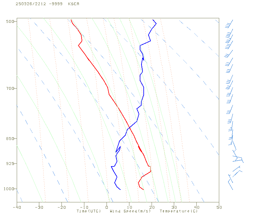
But the problems were worse than that! Easterly winds were developing aloft, with sinking and warming air above the cool low-level air. This situation was being observed in real time by aircraft coming in and out of Seattle and Portland.
The aircraft vertical profile at 3 PM is shown below. The red line is temperature, and the Y-axis is height.
A strong low-level inversion existed with temperature warming with height....this is fatal for severe convection.
Any reasonably trained meteorologist should have recognized that the severe weather threat was toast, and this message needed to get to the public and the media, who had been headlining the threat of tornadoes, hail, and powerful winds.
I was not a little disappointed that the Seattle NWS office did not realize what was going on and did not put out a message about the threat being over.
When it became clear that they were not doing so, I decided to put out a blog about it.
The amateur weather sites, who so hyped the threat on YouTube and BlueSky/X, did not pull back either.
The Seattle NWS got a lot of complaints on their social media and put out a graphic "explanation" of the failure (see below). Not satisfactory.
Bottom Line
Weather prediction has gotten immensely more skillful during the past decades. But as good as models have become, they still have failure modes, and this event played to them (e.g. over over-mixing of shallow cool air, complex orographic effects, and more).
Experienced human forecasters are still needed to catch model failures and to make necessary adjustments to ensure the public is not underwarned or overwarned.
Clearly, the NWS could have done much better in this case and I think a serious review is in order.


.jpeg)