February 27, 2022

A Major Precipitation Event Has Begun

The atmospheric river has reached the Pacific Northwest and moderate rain has spread across much of the region.

The water vapor satellite imagery is impressive, showing a potent plume of water vapor moving northeastward from off the Pacific (see below).  Looks scary, doesn't it?   

Some folks rate atmospheric rivers like hurricanes and tornadoes, and they rank this event as an AR4 (atmospheric river, category 4), out of a possible 5.


This atmospheric river not only has moisture, but strong winds from the south-southwest, producing a very impressive rainshadow to the northeast of the Olympics (see radar image at 7:30 PM below).  Yellow and orange indicated the heaviest precipitation, with the southeast side of the Olympics getting the worst of it now.   In contrast, it is TOTALLY dry from Sequim to northern Whidbey Island in the rain shadow.   So if you want to go on an evening stroll...you know where to go.


The precipitation total so far (through 7 PM) is shown below.  Over an inch has accumulated on the southwest flanks of the Olympics and some favored areas in the Cascades, but only .01 inch on southern Lopez Island in the San Juans.    And folks, this is just the beginning.


It is not uncommon to get 100 to 1 precipitation ratios around here between the rainshadow and the windward, wet side of our local terrain.  We have the most extreme gradients of rainfall in the world.   Something to be proud of.

The latest precipitation forecast starting from 4 PM today (Sunday) through 4 PM Tuesday from the NOAA HRRR model predicts 5-10 inches in the mountains, with even heavier precipitation in the southern Washington Cascades.  3-5 inches over southern Puget Sound. That is unusual.   Expect some urban flooding.


And the NOAA/NWS River Forecast Center is still going for major flooding on the Snoqualmie and moderate flooding on many others.  There will be road flooding in low-lying spots near rivers.


A major positive of this event will be the substantial rain that will fall over far eastern Washington, helping to restore soil moisture for dryland farmers there (see precipitation total for the event below).  The strength and direction of this atmosphere river are well-structured to bring moisture into eastern Washington.  Very good news.


February 26, 2022

Very Heavy Rain and Flooding Coming to the Northwest

 For those thinking that a lamb-like spring was coming early, think again.

Very heavy rain and flooding will be arriving on Monday, the result of a potent atmospheric river.  Some locations in the lowlands will receive 2-4 inches on Monday, with twice that in "favored" mountain locations.

The origin of our wet future is a strong atmospheric river, a narrow region of large amounts of moisture, originating in the subtropics.  To illustrate, below is a plot of total moisture from the surface to the top of the atmosphere at 4 AM Monday.  As you might guess, the reddish colors are the largest amounts.

This atmospheric river starts north of Hawaii and heads northeastward right into our region.


But it is not only moisture that counts, but the rate at which moisture is approaching our region.  

That is why meteorologists prefer to view integrated water vapor flux (IVT), an impressive-sounding term that actually means wind speed times water vapor.  Just drop the term "IVT" in your conversation and your friends and family will be impressed!  

Here is the plot of IVT for 4 AM Monday.  The blue values are very high.   A fast-moving river of moisture is heading straight for us.


And when that river of moisture is forced upward by our regional terrain, an amazing amount of precipitation will be released.  Consider the latest University of Washington high-resolution precipitation forecast for the total accumulated precipitation through 4 AM Tuesday.  

Wow.  2-3 inches over Puget Sound and as much as 7-10 inches in the mountains.  Profound rain shadow from Sequim to northern Whidbey Island.


The highly skillful, but lower resolution, European Center model is going for a big event as well, with 3-4 inches in southern Puget Sound, and even Portland getting a food piece of the wet action.  The Olympics and coastal mountains get staggering amounts of precipitation.


For snow-lovers, this is not going to be the event you wanted, because atmospheric rivers are generally associated with warm air, and this is no different.  On Monday, the snow level will rise to 5000-6500 ft, so heavy rain will descend on the passes.

I would not go skiing on Monday.

With such massive amounts of rain, local rivers will rise rapidly, and flooding is expected on several.  Here is the latest river forecast from the NOAA/NWS River Forecast Center in Portland.  Minor to major flooding on several (orange and red dots), which is impressive considering that the rivers are starting out below normal after the recent dry weather.


The Snoqualmie River will get very, very close to major flooding (see a plot of river level below).  Expect some road closures.


But with all the problems, it will be good to get a good wetting for the region, with the rain thoroughly saturating the soils on both sides of the Cascades (good for agriculture) and pushing large volumes of water into regional reservoirs.  


February 25, 2022

A Major Shift in the Weather: Warm and Wet Returns. Plus, Why Cold Temperatures Vary so Much.

 My new podcast is out (see details below), and I cover two important topics:  the radical change in our weather that will occur this weekend, and the substantial variations in local temperatures on cold nights.

Take a look at the upper-level (500 hPa, about 18,000 ft ASL) flow this morning and on Monday night.  This morning, the ridge is right on the coast--a situation associated with sinking air and sunny skies.


But on Monday evening, the ridge has moved inland and the Northwest is in strong southwesterly flow off the Pacific.  A large trough is offshore.  This is a warm/wet pattern.


Total precipitation through 4 PM Monday is impressive (see below), with locations in the mountains getting more than 5 inches!


My podcast gives more details on the forecast.  And my podcast also describes and explains the large local variations of low temperatures on cold mornings, such as on Wednesday.

It all makes sense if you know what is going on, and you will after you listen to the podcast.

To listen to my podcast,  use the link below or access it through your favorite podcast service.


Some major podcast servers:

 HTML tutorial HTML tutorial
Like the podcast? Support on Patreon 


February 23, 2022

Light Snow Tonight and Tomorrow Morning Over Northwest and Eastern Washington. And Cold Record Fall.

 More snow is coming tonight for the lowlands of Northwest Washington and the Columbia Basin.  

But before I get into that, check out this morning's visible satellite image showing a nearly cloud-free Washington State and northern Oregon.   Just spectacular.  

You can see the snow over the mountains as well as regions of non-mountain snow over the eastern Washington and Oregon lowlands. 


As predicted, this morning was very cold across the region, with several observing stations with temperatures dropping to daily records (see below). Over the lowlands of western Washington and Oregon, many locations dropped into the teens, particularly away from the water.   East of the Cascades, single digits were prevalent, with some locations dropping below 0F.   One location in eastern Oregon declined to -10F!


As noted, daily low-temperature records were broken at several locations, such as Seattle 23° (old record 24° in 2018),  and Olympia 14° (old record 16° in 2018). 

A weak upper-level disturbance, embedded in northwesterly flow aloft, will move through tonight and tomorrow morning.  The result will be light snow.  Below is the forecast by the UW high-resolution model of snowfall through 10 AM tomorrow.  Up to about an inch over Northwest Washington and the Columbia Basin, with even more on the northwest side of the Olympics, forced by northwesterly (from the northwest) airflow moving up the terrain.


With such a wind direction (northwesterly), central and southern Puget Sound is in the rainshadow of the Olympics, and areas on the eastern slopes of the Cascades are in the rainshadow of the Cascades.

I should note that the latest National Weather Service high-resolution model (HRRR) forecast for the same period is similar (see below), but pushes the light snow into north Seattle.


I should note, that such detailed forecasts were not possible twenty years ago.  We have come a long way!

Finally, a major snowfall looks likely in the Cascades and mountains of BC on Sunday into Tuesday.  More later.

February 22, 2022

Light Snow and Cold. Next Up: Thursday Morning Snow Potential

The forecast models did quite well during the past day, with the cold air and light snow moving in yesterday and this morning.

Yesterday light snow fell over the northeast Olympic Peninsula, with a band extending over northern Kitsap and Camano Island.   And this morning, very light snow fell over Puget Sound (see picture below).  A few flurries are now occurring, but those should end soon.


Bellevue, Courtesy of Dr. Peter Benda

The lows last night in the west ranged from the mid-20s around Bellingham to roughly 30F in western WA and Oregon away from the water.  Teens were prevalent in eastern WA, with some single digits into terrain.  But the coldest temperatures were in valleys of the uplands of eastern Oregon, where one station got to 1C.


The air is now cold enough to snow throughout the region, but precipitation is essentially over as the upper-level trough that provided uplift moves away.  

Winds coming out of the Fraser River valley were extraordinary last night, with gusts getting to 55 knots (63 mph) in Bellingham.  Take a look at the winds at 1 AM this morning....a strong, cold current of air was flowing out of the narrow Fraser River Gorge.  Wind chills near 0F.  

Today will be a cold, dry day with highs in the upper 30sF in the west and 20s east of the Cascade crest.  The sun is too strong now to stay uber-cold during the day.

But tonight, with the sun down and earth radiating to space in cloudless skies, the temperatures will plummet, with lows in the lower 20s in the west and single digits to around 10F in the Columbia Basin (see the forecast for 8 AM Wednesday below from the National Blend of Models).  I have already talked to the city of Seattle emergency management folks about opening shelters for the homeless.

Minimum Temperatures at 8AM Wednesday Produced by the NWS National Blend of Models (courtesy of WeatherBell).

But the threat of lowland snow is not over!  

A weak disturbance will move southward across the region early Thursday.  At this point, the models are predicting some light snow over northwest Washington, but little over central and southern Puget Sound (see snowfall prediction for the 24h period ending 4 PM Thursday). 

Why no snow over Puget Sound?   We will be in the rainshadow of the Olympics under northwesterly flow aloft. The folks in Sequim will be jealous!  


We need to watch this one carefully--small errors could move the snow area.

Temperatures should warm up to near normal by this weekend.   The models indicate this. 

 But there is an even more potent predictor of warming temperatures and spring, one that the false-spring folks at the Seattle Times should do a story on (see below).  The arrival of garden supplies at local supermarkets.  


February 20, 2022

Record Late-February Cold, Puget Sound Snow, and Snowy Cascades

 Record cold, heavy mountains snows, extreme winds, and lowland snowflakes.

Winter conditions have returned to the Northwest.

Heavy snow fell across the Cascades last night, with nearly two feet at Stevens Pass and about a foot at Snoqualmie.  Chains are now required for both passes.

The snow was particularly heavy in the central Cascades.  Why?

Because a convergence zone, forced by the Olympics, created a band of enhanced precipitation, stretching across Puget Sound and into the Cascades, something illustrated by the radar image around 4 AM this morning (the red arrow shows the band) 


Cold Air in Two Stages

A Pacific cold front, associated with an upper-level trough of low pressure, moved through yesterday, with cooler air and northwesterly flow (from the northwest) aloft.   Thus, the bountiful snow in the Cascades.  This was stage one.

In stage two, cold air pours into central British Columbia and pushes southeast of the Rockies, as the upper-level trough of low pressure over the Northwest strengthens and extends southwestward.    Thus, by tomorrow morning a very chilling situation is set up (see surface pressure map at 8 AM Monday, colors are temperatures about 2500 ft above the surface).

Very cold, subfreezing air will be in place over BC and northeast Washington and eastern Montana, with modified arctic air in eastern Washington and Northwest Washington.  With high pressure over BC and a low center of southwest WA, cold air will push through the Fraser River Valley into Whatcom County and western WA.


The winds pushing into Bellingham and the San Juans will be cold and ferocious, gusting to 40-60 knots (see wind gust forecast for 10 AM Monday).  The dark blue colors are the strongest. Dangerous stuff for the unprotected.


With cold air pouring into the region, temperatures will plummet throughout the Northwest, with the coldest temperatures on Tuesday and Wednesday morning.    Low temperatures in the low 20s in the west (and some locations in the teens) and around 10F in eastern Washington, with colder locations getting into the single digits.   

Take a look at the National Weather National Blend of Models predicted minimum temperatures for Wednesday morning (graphic below courtesy of WeatherBell).


Extraordinary low temperatures (near 0F) will be observed over eastern Oregon, and even the Willamette Valley will have some locations dropping into the upper teens.

A number of locations in our region will experience record-low daily temperatures (lowest temperatures for those dates).

With such cold temperatures, you should protect vulnerable plants.  Municipal authorities should ensure that the region's large homeless population is off the streets.  Strong winds will create dangerous wind chills in much of the region.  Unprotected individuals could die of exposure.

Lowland Snow

I don't want to hype this.  Western Washington is not going to get a major snowstorm.  But some lowland residents will see white flakes, particularly Monday morning.

The "problem" is that the main upper trough will be south of Washington by the time the primo cold air gets in on Monday.  So strong upper-level forcing of snow will be absent.

Thus, snow will depend on localized areas of upward vertical motions.  Let me demonstrate.

The UW model forecast snowfall through 4 PM today (Sunday) shows snow in the mountains, driven by the cool, northwesterly flow.  Where the snow belongs.


But as cold winds surge out of the Fraser River Valley and northwest Washington, they will be pushed upward by the Olympics, and the predicted result will be substantial snow extending from the northeast Olympic Peninsula back to Whidbey Island.  The normal rainshadow in reverse.


Some snow is predicted to fall over Puget Sound (very light) at the leading edge of the arctic air pushing out of the Fraser River Valley.  

We call this Arctic Front snow, and it won't add up to much.  What makes this forecast even more difficult, is that cold high pressure in eastern Washington will force some downslope flow over the west side of the Cascades, which works against the snow.

In such a marginal, locally forced situation, uncertainty is large.  For example, here is the latest forecast of the NOAA/National Weather Service HRRR model, which pushed more of the northerly flow into Puget Sound.  The forecast only goes through 1 AM Sunday morning, but more snow is predicted over Puget Sound than in the UW simulation.


One way meteorologists define uncertainty is by using ensembles of many forecasts.  The University of Washington high-resolution ensemble snow forecast for Seattle shows a large variation in possible snowfalls (see below), from .2 to .9 inches.  No forecast gives a big snowstorm.  And snow depth is always less than snowfall.


The Bottom Line

The mountains are being hammered with 1-2 feet of snow.  Very good for skiers and water resources. Little uncertainty

It is going to get very, even record, cold on Monday through Wednesday, with western Washington high temperatures just getting into the 30s and lows in the 20s and teens.  Eastern Washington and Oregon will be even colder.

Localized snow will fall near sea level over limited areas of western Washington, with the northeast Olympics being the most probable, but with potential for light snow over Puget Sound as the "Arctic front" moves southward.

Enjoy


February 18, 2022

Cold and Snow is Coming to the Pacific Northwest. The Story in My New Podcast

 A late February cold snap with snow is coming to the region, and my new podcast provides the details.

The instigator of the cold fun is an upper-level trough (area of low pressure) that will move southward along the eastern side of a huge northeast Pacific ridge of high pressure.

Upper-level flow (500hPa) Late Saturday

Initially, western Washington will be too warm for snow, but the mountains will enjoy bountiful flakes (see snowfall total through 10 PM Sunday)


But as I describe in the podcast, on Monday, western Washington has a snowy chance, as a Puget Sound convergence zone forms south of Everett (see snow total through 4 PM Monday).  Some snow may also occur on the northeast side of the Olympics (e.g, around Sequim) as northeasterly flow moving out of the Fraser River valley is forced to ascend by the terrain.

Snowfall total through 4 PM Monday

To listen to my podcast,  use the link below or access it through your favorite podcast service.


Some major podcast servers:

 HTML tutorial HTML tutorial
Like the podcast? Support on Patreon 


Reminder:  I will have a special online session tomorrow at 10 AM for Patreon supporters.

And I will provide a snow update in a blog on Sunday.

February 17, 2022

Is the Southwest U.S. Experiencing a Megadrought Fueled by Global Warming?

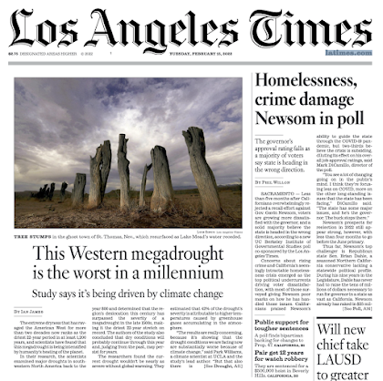
During the past week, many major media websites have headlined a study by some UCLA researchers suggesting that the Southwest U.S. is in a megadrought--the worst in 1200 years-- and that global warming is the prime cause.    

To illustrate, below is the front page of the LA Times.  And the Seattle Times highlighted the megadrought claims as well.  


Unfortunately, there are some major problems with this study and many of the hyperbolic claims--as I will explain below.   

The US Southwest has clearly experienced a dry spell recently, but global warming (a.k.a. climate change) is only a minor contributor compared to natural variability.  Decadal dry periods are not unusual or unknown for the U.S. Southwest.  They have happened many times before during periods when human-caused climate change could not be the origin.

Why 22 years?

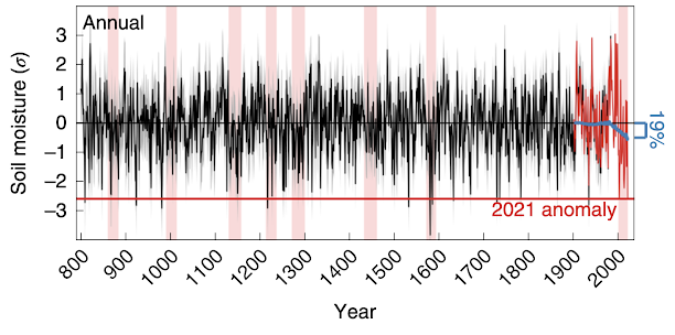
A key aspect of this paper is its claim that the last 22 years were the driest over the southwest U.S. for the past 1200 years.   Their measure of dryness was soil moisture and they secured this indirectly by relating tree ring chronologies to such moisture.   Here is a plot of soil moisture from their paper:

Figure 1b from Williams et al. 2002.  Nature Climate Change.  The soil moisture 
is expressed as standard deviations from the mean.

Tree rings are, of course, imperfect measurements of soil moisture, but let's put that aside for the moment.   

You will notice a lot of ups and down in southwest U.S. soil moisture, and that in most ways, the recent dry period is unremarkable.  In fact, there were many previous events in which the soil moisture was drier.  There were many periods when the soil moisture was low (say less than -1) for longer periods.

Now, I am not a little surprised that none of the "curious" media stopped for a moment and asked:  why did these researchers pick 22 years?   Why not 25 years,  30 years, or 50 years?

The answer is that their whole narrative, their whole claim of unusual drought, would have weakened greatly if they had used 25 years or 30 years or anything longer.

You can see the issue from the plot above.  The soil moisture was in fact VERY HIGH during the 1990s, including 1998.  If they had used a longer period, they would have found more normal conditions.   

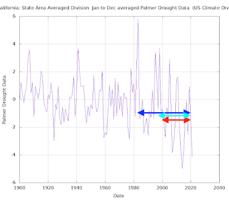
If you want to see this more clearly, let me show you the Palmer Drought Index over California during the past 120 years (see below).  This index combines temperature and precipitation and is a reasonable thing to compare to their soil moisture index.

The 22 year period (red, -1.51)) has an average that is much lower than the past 30 years (blue -.93) or the past 25 years (cyan, -1.24).   This effect is even larger if you look at precipitation.  By selecting 22 years they avoided the wet period in the mid to late 1990s.

Now I am not comfortable with their approach, with claims of megadrought dependent on selecting the exact period over which it recently has been dry.
_________________________________________
Addition

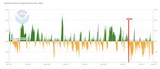
A NOAA website just came up, and using it I have plotted the Palmer Drought Severity Index for the whole Southwest.   I put a line on the year 2000.  You will see that the Williams et al study selected the driest period for analysis...the optimally dry period, with a much wetter period preceding.  Such a rapid transition is not the expected impact of global warming, which would tend to change temperature/moisture gradually.

_____________________________________


What is the origin of the two-decade dry period?

There is little doubt that it has been relatively (but not record) dry over the southwest U.S. during the past two decades.  The authors of this paper claim it is mainly due to global warming, but there is strong evidence that this is not the case.

Something unusual has been going on during the past 20 years:  persistent ridging (high pressure) during the winter over the northeastern Pacific. And such high pressure has kept storms away from the southwest U.S.  

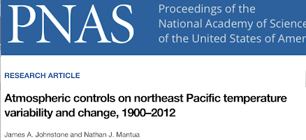
Several highly regarded atmospheric scientists have investigated this issue and have found that the persistent high pressure and associated warm sea surface temperatures off the West Coast are due to natural variability, not global warming.   This (Johnstone and Mantua 2014) work has been published in the peer-reviewed literature  (see one below).

To provide one quote from this excellent paper:

These results suggest that natural internally generated changes in atmospheric circulation were the primary cause of coastal NE Pacific warming from 1900 to 2012 and demonstrate more generally that regional mechanisms of interannual and multidecadal temperature variability can also extend to century time scales. 


Specifically, natural variability, like changes in the Pacific Decadal Oscillation, is what forced the unusually warm, dry conditions of the past 20 years, and there is no evidence that global warming is contributing.

The authors of the megadrought paper, for some reason, ignored the obvious role of natural variability but focused on output from global climate models (GCMs).  Such climate models, forced by increasing greenhouse gases, simulated substantial warming during the past 20 years, drying the soils and thus leading to the author's claims that the 22-year megadrought was mainly the result of greenhouse gas emissions.

But there are substantial problems with such models and their application to this problem.

Climate models are known for their failure to properly simulate (or simulate at all) key modes of natural variability like the Pacific Decadal Oscillation.   The particular models used in this work (CMIP-6) are well known to be overly sensitive to greenhouse gas concentrations.   There are substantial problems with global climate model physics, such as their unphysical cloud coverage (something I am researching) and poor simulation of convection (thunderstorms).    And there are many other known deficiencies.  In addition, these models have been tuned to match the climate of the past century, which may undermine their ability to predict the future reliably.

In short, just because the climate models were producing warming over the southwest U.S. does not mean that increasing greenhouse gases were actually the cause, particularly when there is very good published science that suggests otherwise.  Furthermore, the climate models have well-known major deficiencies.


In Summary

The southwest U.S. has always experienced periodic droughts that have extended over decades and the fact that this has occurred for thousands of years shows that global warming from increasing greenhouse gases is not the cause.  This is part of the meteorology/climatology of the region.

We are in the midst of a dry period that is not particularly unusual in intensity and there is strong evidence that it is the result of natural variability.

The best science we have now suggests that increasing greenhouse gases will have uncertain effects on southwest U.S. precipitation during this century.  Regarding temperatures, at this point in time, global warming effects are probably small compared to natural variability but will increase during this century as greenhouse gas emissions increase and the atmosphere and ocean slowly warm.


Announcement

I will be having a zoom session with Patreon supporters on Saturday at 10 AM.

Should I Let AI Write My Blogs?

I spend a lot of time thinking about and writing my blogs.   Could AI apps do the work for me?   Could any of you tell the difference? Well,...