August 30, 2024

From the Freezer into the Fire: Extreme Daily Temperature Temperature Change on Thursday

 Can you imagine waking up with a sub-freezing temperature of 14F, with ice and frozen soil, needing a heavy jacket and something to warm your head?

A few hours later, the temperature jumped to 83F, and you dreamed of AC, shorts, and some icy drink?


A daily (diurnal) temperature change of 69F!   

You might think you were mad or dreaming.

It happened, in Seneca, Oregon yesterday.  But why?

The station in question was the Seneca BLM Agrimet site located at 4600 ft in a high mountain basin in eastern Oregon (location shown by red marker on maps).


Being in such a basin turns out to be very important.  

To show this, here are the minimum temperatures that morning (again the morning of August 29).  The coldest temperatures are in the Seneca depression, with the 14F observation at the lowest portion of the basin.  A few miles away in the surrounding hills, temperatures only fell into the 40s!

So what is going on?

Our nights are getting longer, so there is more time for cooling at night.   The skies were clear yesterday morning and afternoon, allowing good solar heating during the day and effective infrared cooling at night (see satellite image Thursday morning).   Clouds both reflect solar radiation (reducing the daily maximum) and act as blankets at night, reducing the ability of the surface to cool by emitting infrared radiation.


The air was dry over eastern Oregon, with relative humidity yesterday morning well below 100% (see map)


 Dry air allows better cooling at night and reduces the chance of warming fog.  

So Seneca had great cooling at night and full sun during the day.  The cool temperatures on Thursday were aided by a slug of cold air that had moved in the previous day (see map of the difference 5000 ft temperatures from normal on Wednesday).  Blue is colder than normal.


Cold air is denser and heavier than warm air and tends to settle into basins and valleys ---just like the one around Seneca.  There was undoubtedly warmer air a few hundred feet above the ground


The cold air in the valley was not very deep and during the day solar heating of the surface caused the cold air to be mixed out, resulting in a surge of temperatures into the 80s.

Here is a view from the surface near the Seneca weather station.  You can see the surrounding hills in the background.


The high mountain valleys of eastern Oregon are well known for amazing cooling at night and a large temperature range during the summer months.  Here is a map of the typical daily (or diurnal) range across the US during July.  Eastern Oregon is probably the "best" place in the nation to freeze at night and fry during the day.  Not sure if that would attract tourists.


 Seattle's diurnal variation for the same day was only 65 to 79F, just 14 F.  

Embarrassing.


August 28, 2024

Vote Yes for Washington State Initiative 2117

If you care about high energy prices, fairness to low-income residents, honesty by governmental officials, and effective approaches to dealing with global warming, you should vote for Washington State Initiative 2117.


This initiative would repeal the Washington State Climate Commitment Act (CCA), which was approved by the Washington State legislature in 2021.    This act requires 
businesses with emissions exceeding 25,000 metric tons of carbon dioxide per year to purchase allowances, which increases the cost of gasoline, natural gas, and other energy sources dependent on fossil fuels.  

According to the best estimates of its impacts, this act has raised the price of gasoline by approximately 50 cents per gallon.  A few months after the CCA went into effect, Washington State had the most expensive prices at the pump in the nation, while today we are number two to California, which also has such a tax (price per gallon is shown below, yellows are the highest prices).


The CCA also made natural gas more expensive, substantially raising the cost of heating, and since most items are moved by truck, it raised the prices of food and other necessities.

To illustrate, consider the price of natural gas used for heating in the Seattle Metro area, compared to the rest of the country.  In 2020 and 2021, our gas prices were similar to the rest of the nation and in 2022 ours was less expensive, but after the CCA went into effect (January 1, 2023), our gas prices soared ahead of the rest of the nation.


Truth Should Matter

When Governor Inslee was pushing the CCA back in 2021 he stated:

His advisors had told him otherwise.  To put it politely, our Governor was not being frank and honest with Washington State citizens.  Good leadership including leveling with the public.

A Highly Regressive Energy Tax That Hurt Low-Income Folks the Most

There is a lot of talk about equity and fairness today.  The CCA gas tax is highly regressive, with low-income folks experiencing a much higher percentage increase in their basic costs to survive and work.

Furthermore, wealthier folks can afford expensive electric cars and install charging stations in their homes.  Charging is not so easy if you live in an apartment.

I got a real feeling for the opinions of working-class folks when I gave a talk to a group of grounds maintenance workers.  When I mentioned my opposition to regressive gas taxes, the entire group started to applaud.   Several of them came up to me afterward, telling me about their long commutes and the onerous costs of filling their gas tanks.  


The CCA has collected enormous amounts of money during the last year and a half: over two billion dollars.

By the way, who do you think are the top two donors for the effort to stop I-2117?  Two Microsoft billionaires:  Steve Balmer and Bill Gates.  I bet they don't worry about the cost of filling their gas tanks.

A History of Carbon-Tax Initiatives

I, like many others, am concerned about global warming.   Back in 2016, I supported another carbon tax initiative  (732) because it wasn't regressive, reducing the sales tax and returning substantial funds to low-income residents.  The governor and climate activists were against it because they did not get any of the money.

Two years later, the Governor and the activists, pushed another carbon tax (I-1631), one in which special interests and pet projects got the cash.  It was highly regressive and was soundly defeated (I was opposed to I-1631 because it was unfair to low-income folks).

The Climate Commitment Act (CCA) was passed in the state legislature in 2021.  

A Very Ineffective Way to Fight Climate Change

Most of the cash from the CCA has been wasted on bureaucracy and inefficient pet projects, with little impact on carbon in the atmosphere.   For example, the two biggest ticket items are:

• $429 million for public transit grants and projects, including free transit for youth under 18 • $223 million for active transportation projects, such as bike trails and safer sidewalks and crosswalks

Free transit for youth is fine, as are safer sideways, but these efforts will do little to fight climate change.   Very little funds were made available for fixing Washington State forests (e.g.,, thinning and prescribed burning).   The carbon footprint of our state is still going up.   Very little progress is being made.

Consider the greenhouse gas emissions in Washington State provided by the Federal government that also includes gases besides CO2   (below).  Virtually no downward trend through 2021.  Very disappointing performance. Huge increase in 2022 due to improved reporting requirements.  So you can't compare that year with the others.


The Way Forward

The regressive CCA gas tax, which severely hurts low-income residents and has done little to reduce our carbon footprint, should be eliminated.  We can do this by passing I-2117.

Then we need new state leadership and better approaches for dealing with climate change.  Like a substantial increase in the use of nuclear energy.   Like planning for additional dams and reservoirs.  Like FINALLY getting serious about restoring our forests. And much more....


August 26, 2024

The Last Frontal System for a While and Cold Records

 The satellite picture this afternoon was very fall-like, with a frontal cloud band extending across the northwest portion of the Olympic Peninsula and lots of clouds over British Columbia.   Offshore, the white dots indicate unstable air and convection caused by cold air moving over warmer water.  


The radar image at the same time shows an impressive line of precipitation associated with the front over the Olympic Peninsula, extending both offshore and into BC.  A few light showers over western Washington at that time.

The temperatures during the past week have been unusually low, with many cold records broken.  

At Seattle, the high was only 59F on Friday, nearly 20F below normal.   

Let me show you the locations in Washington, Oregon, and California that broke records for daily record low high temperatures over the past four days (that is breaking the temperature record for a particular day).  Many daily cold records were broken in Washington, but southern Oregon and northern California just decimated previous cold records for those days.


Now breaking daily records is unusual, but you know you have a rare situation when monthly records are broken--and there many monthly records broken during the past four days.  That means colder high temperatures than ANY day of August.  

In Washington State, the monthly records were mainly over the northeastern part of the state, while Oregon's monthly records were in the southern portion.


 But what was really amazing was the massive number of monthly cold records in California....folks this is one for the cold record books.


There was even snow in the Sierra Nevada Mountains....wow.


Fortunately,  I have some warming news for you:  a warming trend is predicted for the next week and this weekend should be perfect for outdoor activities or a barbecue!

For Seattle, temperatures will rise to about 80F on Saturday before dropping into the low-80s next week.  Dry conditions.


Warmth will also return to eastern Washington this weekend, with the Tri-Cities heating into the upper 90s, before falling back into the comfortable 80s next week.


All and all, a perfect Labor Day weekend is ahead.  And one with minimal smoke over the region!


August 24, 2024

A Tropical Storm Approaches Hawaii: Should They Be Worried?

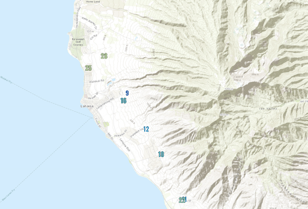
 Just over a year ago, Hurricane Dora passed south of Hawaii and strong downslope winds descended the western slopes of the West Maui mountains,\ resulting in wildfires that destroyed the town of Lahaina and killed approximately 100 individuals.

As I write this, another tropical system, Tropical Storm Hone, is approaching the Hawaiian islands and will pass south of the Big Island during the next 24 hr (see satellite picture below around 6 PM PDT).   The star indicates the storm's center and the arrow points to Lahaina on Maui.


During the past year,  I have worked with UW research scientist David Ovens to understand the meteorological situation associated with the 2023 Lahaina disaster... if you are interested you can read about it here.  

Thus, it was with considerable interest that I watched the approaching tropical storm today, and carefully examined the forecast model diagnostics.

My general take is that although this event is far less of a threat to Maui, it will produce damaging winds in some locations, as well as heavy rainfall.

What are the key differences from last year that make this event less threatening?

First, the storm is substantially weaker and closer and Hurricane Dora of last year.  Closer means substantial precipitation will reach the islands, which works against wildfire danger.

Below is the total precipitation through 11 PM PDT tomorrow.  You can see the swath of rain directly associated with the storm south of the islands.  Enhanced, moist easterly flow connected with the passing storm will produce substantial rain on Hawaii (up to 15 inches) and on portions of Maui.  


A key element of last year's storm was the very high pressure to the north of Maui, which resulted in strong winds approaching the Maui mountains.  These winds interacted with the mountains to produce very powerful, dry downslope winds that directly contributed to the fire.

Today, the high pressure to the north is much weaker than last year, leading to a weaker north-south pressure difference and thus lesser winds approaching the West Maui Mountains (see map of pressure (solid lines) and pressure difference from normal (color)  below).  The blue circular area approaching Hawaii is the tropical storm.


But there is something else...something more subtle....but very important.   The downslope wind response is not only influenced by the wind speed and direction of the air approaching the barrier but the stability of the air as well, with stability dependent on how temperature and moisture change with height.  

The strong high pressure a year ago made the stability variability near the crest level ideal for strong downslope wind around Lahaina (there was a stable layer just above crest level).   The situation is FAR less favorable today.

The greatest winds associated with enhanced northeasterly trade winds tend to be near Lahaina, downstream of the West Maui Mountains, and on the northwest side of the Big Island, downstream of the Kohala Mountains (see red arrows)


Let's check out the latest winds around Lahaina and northeast Maiu...and there are MANY more wind observations today than a year ago.  The maximum winds today (shown below) were only about 25 mph north of Lahaina.


The approaching winds are stronger over the Big Island and the maximum winds have become very powerful on the Kohala coast...reaching 93 mph! (see below).  Wow.


The danger of these winds is mitigated by relatively high relative humidity and the fact that light rain is making it over the crest.  The rainfall over the last 12-h (shown below) has been intense near the crests of the Kohala range (up to around 5 inches), with very light rain reaching the strong wind area on the lee (southwest) side.


At this point, Hawaiian Electric is not shutting off any power to prevent wildfires (see below).  For Maui, I would agree, but northwest Hawaii is another story.

There is plenty of dry vegetation there.  I hope they are making the right decision.


August 23, 2024

Record Breaking Precipitation Imminent for Northwest Washington

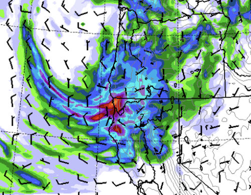
 The current precipitation forecast for precipitation over northwest Washington over the next few days is stunning.....particularly, what will hit the ground tonight.

Many daily records will fall.

Consider the accumulated precipitation through 5 PM on Saturday.  

Unbelievable.  Large areas of northwest Washington will receive more than two inches, some 3-6 inches.


Most of this will fall overnight.  Even more will fall on Monday, with the accumulated totals through 5 AM Tuesday shown below.  There will be localized flooding around Bellingham.


Remember, August is a dry month.  Consider the historical records at Bellingham for August 24th (see below).  The greatest August 24 precipitation total was 1.12 inches.  That record will fall...as will many others.


 The average monthly precipitation for Bellingham is 1.13 inches.... that normal will be smashed.

As noted in previous blogs, the cause of this wet period is a record-breakingly deep closed low/trough aloft (see graphic below for 5 PM today (Friday) at 500 hPa, about 18,000 ft).  


This drenching rain will end the wildfire season over the NW Washington area.  But let us not forget southern Oregon and northwest California, which will get very wet as well.


Finally, I  have been hard on the Seattle Times when they provided inaccurate and exaggerated information about heat, drought, and climate change.  So let me acknowledge that they finally did a story that highlights cold and rain.😀


August 21, 2024

The Great Cooling is Imminent

 You better get your sweaters out.  And your umbrella.

You will need them as very cool temperatures are ahead, with Friday's and Saturday's highs around 15F cooler than normal.

Cool temperatures with bountiful rainfall over the region.

Some Northwest locations may cool to near freezing. And snow will return to the higher elevations.


Let's start with the accumulated precipitation beginning this morning.

By tomorrow at 5 PM, rain has accumulated over Vancouver Island and the coast.


Through Friday at 5 PM, western Oregon and NW California are soaked.


And then on Saturday, western Washington gets pummelled by heavy rain.  This is going to put a serious damper on forest fires west of the Cascades for the remainder of the season.

Looking more carefully at western Washington, the rainfall totals through Sunday morning are stunning (see below), with most of the region getting more than an inch.  August will come in with above-normal precipitation totals.


And then there will be the cold-- the Big Chill of August 2024.

For Seattle, weather.com predicts a high of 63F on Saturday (below) and the mid-70s in the Tri-Cities. The normal high for Seattle right now is 77F.


The UW's WRF weather forecast model shows amazingly cold temperatures on Saturday morning, particularly over eastern Oregon (see below).  

Temperatures dropping to the 30s are extensive both in eastern Oregon and in the Cascades.  Some cold spots will experience their first freeze of the season.


Daily cold records will probably be broken over the weekend.

And what about snow?

The total snowfall through Sunday morning shows flakes at the higher elevations of California, Oregon, Idaho, and Washington.


What is the cause of this cool/wet event?    

Answer: an unusually strong upper-level low parked off the Oregon coast (see upper-level map at 2 PM Friday).


Certain local newspapers have had strong headlines when the region has been warmer than normal.  Will they give similar treatment to the extremes that go in the other direction?


A Near Perfect Forecast of Yesterday's Event. The Next Windstorm Comes into View

 The next time someone makes a weatherperson joke, remember the nearly perfect forecast for yesterday's wind event over Washington. No l...