Global warming must be dealt with scientifically and rationally, not with pork barrel politics.
Unfortunately, in Washington State, we now have the Climate Commitment Act (CCA), an ineffective, wasteful political giveaway that does little to deal with global warming
You can help the state deal more effectively and justly with climate change by voting YES on Initiative 2117.
The CCA is doing little to slow WA emissions growth
If you are like me, you care deeply about the environment and worry about the long-term effects of human-caused global warming. I have studied the issue of climate change in the Northwest more than anyone, giving me a realistic view of its impacts. And when Congressman Jay Inslee wanted to gain a basic understanding of climate change, his staff called me and I met with the Congressman at my offices at the UW.
What did I tell him, backed by the best science available?
Global warming is a serious concern but not an existential threat.
We need to deal with the problem in a rational and balanced way.
As I will describe, the legislatively adopted CCA is wasteful and ineffective. It is highly regressive, preferentially hurting low-income people. It is also an obstacle to effective action regarding human-caused global warming.
If you care about the environment, vote YES on I-2117. We must replace the CCA with measures that are more effective and ethical.
Reminder: the Climate Commitment Act established a cap and invest system, where the annual CO2 emissions by the state are capped, with major emitters paying money to bid on emissions allowances. The result is increasing prices for gasoline, heating fuels, transportation, and many things we buy. The sales of emission allowances have given the state government billions of dollars for a politized environmental "slush fund."
Why the Climate Commitment Act is Essentially Flawed and Must be Replaced
(1) Flying Blind
The central goal of the CCA is to reduce carbon emissions in Washington State. To do so, it is essential to have recently updated emissions data to know whether actions funded under the act are working and to make adjustments if necessary.
The most recent emissions data available from the State of Washington? You are not going to believe this. 2019. Five years ago.
Can you imagine being a captain of a ship headed to a specific port and the only information you had was the path of the ship five years ago? You would have no chance of reaching your destination.
The same thing is true of the CCA. A serious effort to reduce carbon emissions requires near real-time information.
(2) No Requirement that Projects Have Specific Emission Reduction Goals
Billions of dollars are being spent on CCA projects. Unbelievably, there is no requirement for these projects to estimate or project how much they will reduce carbon emissions. The vast majority of projects provide no such information.
You can't reduce emissions if the projects you are funding provide no information on how they would reduce emissions. Pretty obvious.
(3) No Tracking of the Effectiveness of CCA Projects
Vast sums are being dispersed to hundreds of CCA projects, but there is NO TRACKING of whether the projects are successful in reducing emissions.
You can't solve a problem if you don't know whether your actions are working.
Can you imagine paying someone to paint your house and not checking on whether he/she finished the job? Or even started it? This is what the CCA is doing. Unbelievable.
(4) Much of the CCA Money is Spent on Projects That Will Make Little or No Contribution To Greenhouse Gas Emission Reduction
The CCA gives new meaning to the term "pork barrel politics", dividing the CCA funds among well-connected special interest groups, with many of the projects having nothing or little to do with reducing greenhouse gas emissions.
Case in point, one special interest group, the Cascade Bicycle Club, noted the CCA will supply 1.3 billion dollars to improve bike lanes and pedestrian projects. You read that number right.
Do you know the average % of folks in the US who commute by bike?
About 0.5% Do you think that massive investment in bike lanes will have much of an impact on emissions? Not likely. And cycling is getting LESS ecological with the invasion of heavy, electric bikes.
Large sums of CCA money are also being spent on a multitude of other projects that will have little or no impact on carbon emissions.
For example, millions are being spent on fish barriers and habitat, as shown by the dozens of projects shown on this map. We all care about fish, but this has little to do with reducing greenhouse emissions.
Tens of millions of dollars are being spent on "environmental justice communities", with spending ranging from vague administrative tasks to air quality sensors (see map below). Again, little to do with CO2 emissions.
Don't get me wrong. I care about the natural environment as much as anyone. But the bait and switch of the CCA, using money meant for reducing carbon emissions used for other projects is wrong.
The language of the CCA is explicit: CCA money is for reducing emissions (see a statement on the State's own web page below).
Hundreds of CCA projects have nothing to do with greenhouse gas emissions, wasting billions of dollars.
(5) The CCA "Tax" is Greatly Raising Prices for Washington Citizens and is Highly Regressive, Hurting Low-Incoming Individuals the Most
The inception of the CCA has resulted in Washington gasoline prices increasing by 30-50 cents, with increased bills for home heating fuels (natural gas and oil) and for a wide variety of essentials. These increased costs are very regressive: they hurt low-income folks the most since energy costs are a far larger portion of their income. Low-income folks often can't afford expensive electric cars or live in places with convenient chargers.
The Washington Policy Center estimates that the CCA costs the average Washingtonian about $ 500-1000 a year.
The effects of the CCA on gas prices were not small.
(6) The CCA Effort Has Been Supported by Hype, Exaggeration, and False Statements by Politicians, Special Interests, and the Media
Exaggerations, hype, and outright fibbing have characterized the messaging of those pushing the CCA and attacking I-2117.
Governor Jay Inslee stated that ‘Climate change is truly an existential threat for everything we hold dear’ and CCA author State Rep. Joe Fitzgibbon wrote: "The climate crisis poses an existential threat to all our communities."
Let us be clear. This existential business is nonsense. Unscientific and baseless. Global warming is slowly warming the planet and our region. The effects are modest. There is no threat to the existence of our state. Very irresponsible language.
Many media outlets have been equally irresponsible in hyping the effects of global warming, with the Seattle Times being one of the worst offenders. I have written several dozen blogs over the years documenting the false statements in the ST regarding climate change that needlessly worry State residents and poorly inform legislators.
Talking about false statements, don't forget the Governor's claims that gas prices would go up by "pennies" if at all. The truth was very different (around 50 cents per gallon).
Unethical Conduct
In addition to telling tall tales about the CCA, state leadership has also taken actions that were ethically problematic. When the polls this spring and summer showed substantial public support for I-2117, the Inslee administration and state legislature decided to give low-income customers a one-time gift of $200 on their utility bills BEFORE THE ELECTION. Unbelievably inappropriate. The email below from a state administrator shows how it was done.
What We Do Now?
The CCA is ineffective and essentially flawed for many reasons. Importantly, the CCA is wasting huge sums of public money, displacing productive approaches that could meaningfully address climate change.
So what actions should be taken now?
Number one is to vote YES on I-2117 to end the ineffective and costly projects resulting from the CCA.
What are some effective alternatives for addressing human-caused global warming that would be appropriate to do on a state level? Some suggestions are provided below.
(1) Pass a revenue-neutral carbon tax that would allow the market to make decisions, not government bureaucrats. Revenue neutral means that all the collected revenue would be returned to Washington State residents. Such an approach was proposed 8 years ago with I-732., which was defeated when Governor Inslee and others opposed it (they wanted the money).
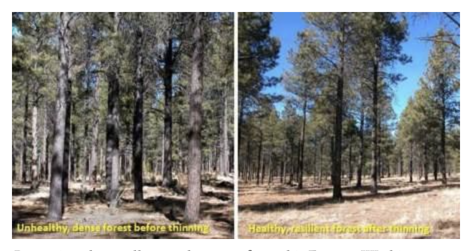
(2) Instead of ineffectively spreading the funds to special interest groups, accomplishing little, use the funds to fix key climate vulnerabilities. For example, a massive program to thin and restore Washington's eastside forests would greatly reduce wildfire impacts. Or building new water reservoir capacity.
(3) Invest in modular small nuclear generation facilities or fund prototype fusion power generation.
Most importantly, be honest with the citizens of Washington State on the costs and impacts of any measures taken.


.png)


.png)


