November 29, 2023

High Pressure and the Northwest's Low-Cloud Affliction

 The visible satellite image this morning was stunning.

Low-elevation clouds covered nearly all of Washington, except for the highest elevations (see image)


Some folks were in fog while others looked at a low-stratus cloud deck.

And this cloudy murk was cold, with much of the state below freezing (see minimum temps this morning).   Freezing fog was widespread.


Cold, cloudy, foggy and icy.  Yuk.

What can you blame for this unpleasant situation?   

Persistent high pressure.  A strong ridge of high pressure aloft.

The upper-level map (500 hPa pressure, about 18,000 ft) on Sunday evening shows the situation (see below).


The difference from normal of 500 hPa heights (or pressure) for the last week was way above normal  (see below, red indicates strong ridging...which is the same as high pressure aloft).

Translation:  the high-pressure aloft was very strong and persistent.


In the summer, such a pattern would give us a heat wave.

But in winter we get a cold wave!  But why?

High pressure is associated with sinking air aloft, which kills middle and upper-level clouds.

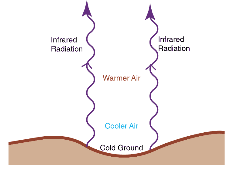
Without clouds, the Earth can effectively emit infrared radiation into space.  There are no clouds to get in the way!  Nights are very long and the sun is wimpy, so solar heating is weak.


The ground cools more effectively than the atmosphere aloft and this helps create an inversion, with temperature WARMING with height.   The inversion is also strengthened by the high-pressure aloft, whose sinking motion warms the air aloft (air warms as it sinks due to compression by the higher pressure at lower levels).

The inversion is a very stable feature and prevents the mixing of air at lower elevations.   It protects the low-level cold air from mixing out.

Want to see the inversion?  Here is a plot of temperature (red) and dew point on the Washington coast at Quillayute on Tuesday morning.  Temperature is increasing with height at low levels.  An inversion!


Each day the air got colder near the surface.  Cold air can hold less water vapor than warm air.  Water vapor starts to condense out into low clouds and fog.

And it is even worse than that.  The top of the clouds reflect solar radiation back to space, enhancing cooling.  Clouds are good emitters of infrared radiation.  More cooling.   Low clouds are cooling machines!

So if you want to blame the cold, cloudy weather on something, blame the high pressure!

We escape this run-away cooling in the summer because of the far stronger solar radiation, which is able to heat the surface and destroy the low-level inversion.


November 27, 2023

Are King Tides a Threat During the Next Two Months?

A number of media stories have been talking about King Tides and flooding during the past few days, and I have gotten several emails from worried readers.

So let's talk about the reason for King Tides and evaluate the threat.

The highest tides of the year...the King Tides... typically occur this time of the year for two reasons.

First, the astronomical setup is ideal, because the Earth is closest to the sun around the New Year.

Second, this is the stormest time of the year, with Pacific cyclones associated with low pressure, and low pressure causes the water level to rise.

Monthly high tides, also known as spring tides, occur twice each month when the sun, moon, and earth are aligned.


And this alignment is enhanced during the winter because the Earth is closer to the sun during our cold period.  Believe it or not, the Earth is nearest to the sun during our winter!  (see below).  Thus, the gravitational attraction of the sun is larger during winter, which produces a greater maximum daily tide:  the KING TIDE.


Finally,  regional low pressure increases the water level.  

How much?  When sea level pressure falls by 1 hPa (or 1 mb), the water level rises by about 1 cm.   So a deep storm that causes pressure to fall by 25 hPa can result in a water rise of around 25 cm or roughly 10 inches.

Now let's look ahead.

Take a look at the predicted astronomical tide levels for November, December, and January below (the green line is today).  For November, tides will max out during the next few days around 12.5 ft above Mean Lower Low Water (MLLW), the average level of the lowest tide for each day computed over a 19-year period.

December will have a number of days (mainly during the middle and end of the month) that will get to the same level.    Mini-King tides.

Mid-January will bring max tides that are a bit higher...around 13 feet....so that will be the time of greatest vulnerability.


There will be little problem of high tides and flooding without a strong low-pressure system moving in...so we need to watch the forecasts for the next few months.   Right now pressure is well above normal...and will remain that way for several days.

Beyond, 10 days the forecasts have little skill...so we are going to have to wait and see.

Want to know about the forecast pressure for the next week?  Check out the ensemble of many forecasts below for Seattle's sea level pressure.  Forecast uncertainty gets very large after December 2 (the forecasts are not in agreement).


The latest model run has a decent storm on December 3 (see sea level pressure forecast below) with a deep low-pressure center heading into Washington State.  Fortunately, the astronomical tides will be low then.


November 25, 2023

The Remarkable Life of Steve Pool

I am very sad to report the passing of Steve Pool, past chief meteorologist at KOMO TV, and a dear friend for many decades.

Steve was one of the most exceptional and generous individuals I have ever known.

A brilliant communicator.  A kind and generous soul.  A highly intuitive and insightful meteorologist. And someone who gave so much to our community.

I first got to know Steve during the mid-80s, when I got a call from KOMO-TV asking whether I would instruct him in meteorology; he had just taken on weather responsibilities at the station.   

For the next year and a half, Steve and I worked together intensively to cover the essentials of meteorology, Northwest weather, and weather forecasting.  An extraordinarily bright guy, Steve quickly mastered a huge volume of weather knowledge and became a very able local weather analyst and forecaster.   He was determined to get his forecasts right, and we would often talk during the late evening before his 11 PM broadcast.

As I got to know him better it became clear to me that he was a preternaturally talented communicator and that I had a lot to learn from him in that domain.  

And I mean much more than a smooth delivery.  He had the ability to connect with people.  A disarming smile, great empathy, and a personality that was upbeat and sunny.  I don't think I ever heard him talk ill of another.


We would regularly talk about difficult forecasting situations, driven by his strong 
commitment to not only get the forecast right but to get the explanation correct.

But Steve had many other dimensions and none were as noteworthy as his dedication to the community. 

One day he called me, suggesting that some UW students could intern at KOMO. This 
internship was a great success, giving roughly 3-4 students a year a chance to 
assist in developing the daily weather offerings at KOMO, including the use of a complex 
graphics system, preparing forecasts, and even practicing in front of the camera. All under the 
eyes and with the assistance of a master weathercaster. 

Many of Steve's student interns went on to successful careers as TV meteorologists, including Shannon O'Donnel, M. J. McDermott,  Kelley Bayern, Nathan Santo Domingo, Jefferson Davison, Scott Sistek, Brandon Wholey and Matt Leach--to name just a few.  Scott  Sistek worked for Steve for 20 years and together they wrote an excellent, conversational book on Northwest weather that received an impressive 5-star rating--Somewhere I Was Right.


Shannon O'Donnell, a past intern, is now chief meteorologist for KOMO.  And in Steve's 
tradition, she is teaching a course in my department on weather communication,  including a Dawgcast available online to the general public. 

Steve's influence will be very, very long-lived.

Steve was extremely interested in outreach to young people, and a good example of his efforts 
was the annual Weather Education Day at Safeco Field. Before the game, THOUSANDS of 
students would enjoy learning about basic weather principles and local weather, presented by 
Steve and his guests (I even did it one time).


Steve became a mega-local celebrity, but this did not change him, and he used that celebrity 
to assist in fun raisers and other gatherings for local charitable organizations and importantly 
for his alma mater, the University of Washington. He helped raise millions of dollars for a 
whole slew of important causes and was the MC for many public events put on by my 
department.  On the side, Steve built a small enterprise, assisting folks in learning how to be accomplished communicators.

Shannon O'Donnell, myself, Steve, and Scott Sistek

Steve loved his family, always talking about his wife Michelle and their talented daughters,
Lindsey and Marissa.  When I went over to his house he talked with great pride of his father, who served in WWII  and was shot by the Germans in northern France after D-Day. Steve was a history buff and had a whole wall of history books in his study, as well as the many Emmys he had won over the years.

But what impressed me more than all his accomplishments was his sheer bravery when his health failed.   I don't want to say any more about it, except that he stayed positive and hopeful to the end, where many would have surrendered to despair.  

An extraordinary human being that has given so much, to so many.  An individual who has profoundly changed our lives in so many positive ways.  He will be missed.


November 23, 2023

A Very Dry Thanksgiving, But No Record

There will be no precipitation over Washington State during the Thanksgiving holiday.

None.  Zippo.  Nada.

Which is kind of surprising since this is the wettest time of the year for our region

To show how unusual it is, here is the climatological probability of measurable precipitation at SeaTac Airport for each day of the year.  The last three weeks of November are wetter than any other period, with roughly a 65% chance of rain on any day.


But this year, there will be no rain--something predicted by virtually every weather modeling system.

For example, the European Center forecast model has nothing through Tuesday morning (see below).


So how unusual is a totally dry Thanksgiving period.  Let's find out!

I found that total precipitation at SeaTac airport for November 23-27 for every year of its record (see below).   2023 will be zero, of course.  There have been several totally dry Thanksgivings, the last being 2015.  About ten Thanksgivings have been dry or very, very close to totally dry.


As shown by the brown line, which shows the trend over the entire period, there is little trend, either up or down, over the period of record (since 1947)

Will rain come back?   The latest model runs suggest the answer is yes, starting later next week.

In fact, the latest NOAA/Climate Prediction Center forecast for 8-14 days is for wetter than normal conditions over the West Coast.  

So enjoy the dry weather....it won't last.

November 21, 2023

Edgy Clouds

Every week, several blog readers send me cloud photos to identify.  So there is plenty of interest in clouds...and for good reason.  A little knowledge about clouds is not only fun but can be useful as well.  

So let me provide some cloud identification 101 today, starting with what you can tell by the characteristics of cloud edges.

Clouds are made up of either ice crystals, water droplets, or a combination of the two.

Importantly, you can differentiate between ice crystals and water droplets by looking at the cloud edges.

Clouds made of water droplets have sharp edges.

Like cumulus clouds:

Or the top of a fog bank:


On the other hand, ice crystal clouds have fuzzy, indistinct edges.

Such as cirrus clouds.


Or cirrostratus clouds:


Did you know that the bases of low-level clouds change sharpness depending on whether precipitation is falling out of the cloud?

When low-level clouds are not precipitating, the cloud base presents a lot of structure (see below)


But once precipitation starts, the cloud base tends to fuzz out and become less sharp and structured. 

In summary, the edges of clouds provide a lot of information for the knowledgeable observer.


November 19, 2023

The Olympics Mountains Can Affect the Weather in Ellensburg and Wenatchee

 The folks living on the eastern side of the Cascades might think that the Olympic Mountains have little influence on their weather....but they would be wrong.

Consider what happened today.

A Puget Sound Convergence Zone set up, producing a band of precipitation stretching from the northeast slopes of the Olympic Mountains, across Seattle and then eastward to near Wenatchee!

Just a reminder before I go on..... Puget Sound Convergence Zones are associated with westerly or northwesterly flow that is deflected around the Olympics and which converges together to the east of the Olympics.

When low-level air converges together at low levels, the air is forced to rise, producing a band of clouds and precipitation.


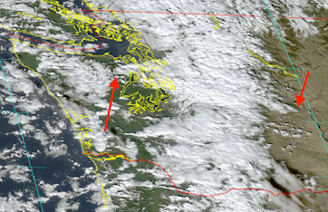
This morning and into the afternoon, a convergence zone formed to the east of the Olympics, creating a cloud band that stretched for many miles,with the cloud band ending near Wenatchee (see the figure below with arrows showing the beginning and end of the convergence zone cloud band).   Interestingly, it was totally clear to the north and south of the band over western Washington... a typical occurrence by the way.


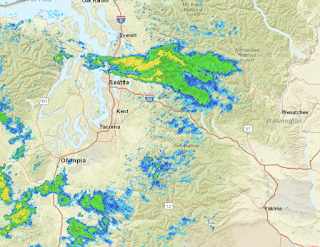
There was rain..some heavy.. within the clouds band, as shown by the radar image around 1 PM.   At higher elevations there was snow.


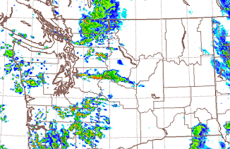
The high-resolution UW modeling system predicted the convergence zone band and its extension across the Cascades (see below).

The Thanksgiving Forecast

It is very nice to enjoy a walk, run, or any other outdoor activity before the holiday mean.  But unfortunately, Thanksgiving is one of the climatologically wettest and stormiest days of the year in our region.

But I have some good news:  Thanksgiving Day 2023 will be dry.   It will be partly cloudy with highs in the upper 40s over western Washington.

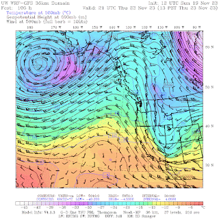
Thursday afternoon, a ridge of high pressure will have built over the eastern Pacific (see the weather map at 500 hPa..about 18000 ft forecast for 1 PM Thursday).  A cool, dry pattern.  I would expect low clouds in the AM, breaking up in the afternoon.  Perhaps you can get enough exercise to deserve a little more turkey or whatever you enjoy...


November 17, 2023

Who Produces the Most Skillful Weather Forecasts?

You have your choice of sources of weather forecasts on various smartphone apps and web pages.

Where can you get the best forecast?     (other than this blog, of course 😊)

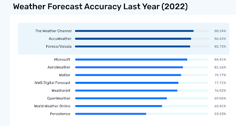
One service, Forecastadviser.com, evaluates predictions from many weather outlets, including the National Weather Service to the Weather Channel (Weather.com).

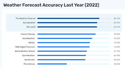
Consider the scores for the last year (2022) for Seattle considering 5-day forecasts.  The Weather Channel is number one, followed by Accuweatther.  The National Weather Service is way down the list!.


How about Chicago?    Pretty much the same thing.  In fact, most cities are similar.

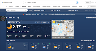
Microsoft has a new forecast system, part of their Microsoft Start effort, that has moved up rapidly to third or fourth place.  During the past month, it has been number one in some cities.

In contrast, the National Weather Service is lagging pretty much everywhere.

So why are many commercial services, whose forecasts are entirely automated, doing so much better than the Weather Service, which includes human forecasts in the loop?

These superior systems start with global observations and forecasts from many different forecast models, such as the European Center and U.S. GFS global models.   Using a history of observations and model forecasts, the advanced systems then create statistical models that combine the various inputs to produce forecasts with lower typical errors.  

Many of the newest systems, such as the Microsoft Start system, make use of sophisticated machine learning approaches to optimally combine the available observations and models.  This process needs to be done at every forecast location, so the amount of computation is not trivial.


With better and better models and more and more observations, these objective forecasts have gotten very good.

So why is the National Weather Service lagging?  

National Weather Service forecasters start with the Weather Service's own system for combining forecasts:  the National Blend of Models (NBM), which is not as sophisticated or capable as the one used by corporate systems (such as IBM's weather.com).  For five-day forecasts, humans add little value...sorry, but that is the truth.

Other verification comparisons show little improvement of NWS forecasters on shorter periods forecasts as well.

Do I have a weather app do I have on my smartphone?  I have to admit: I do.

The WeatherChannel.  

Can I beat the forecast of the Weather Channel?  Yes, perhaps half the time, using the higher resolution UW modeling system and an intimate knowledge of the local weather.  But not always, particularly for run-of-the-mill weather situations.  

The days of human forecasters will soon be over.  However, human forecasters still have a vital role to play in communicating the forecasts and helping local governments and others to make optimal use of computer-based predictions.


November 15, 2023

Will there be skiing for Thanksgiving?

 The answer is possibly, depending on where you are.

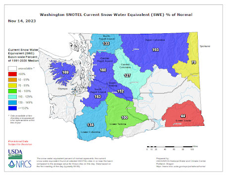
Let's start with a look at the status of the snowpack for Washington State from USDA Snotel (see below).

Most areas are above normal, with NE Washington at 193%.   The cool, wet weather of the past week has really helped.

The NOAA snow analysis this morning shows the greatest depths in the north Cascades and southern BC.   The Oregon Cascades have far less.


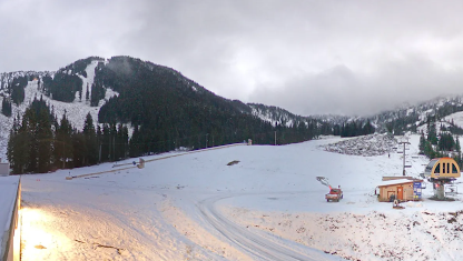
Stevens Pass has about 8 inches on the ground with general coverage, but not nearly enough to open at this point.


The other Washington ski areas are in the same boat.  But British Columbia's Whistler is in better shape and they are planning on opening on November 23. We will see.

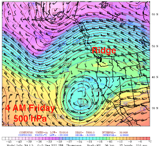
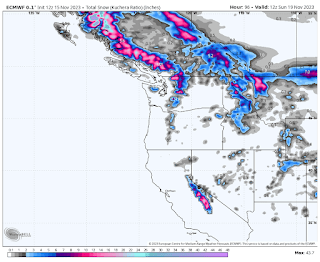
So what is the snow forecast from the UW model?  In the short term, it is not good.  A significant ridge will build over the area for Thursday and Friday (500 hPa--around 18000 ft--shown below for Friday at 4 Am).  This is a dry pattern for the region.

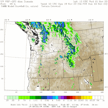
On Saturday, the ridge will break down and a trough of low pressure will bring some precipitation to the lowlands and snow to the mountains.  The snow total from this event is shown below.  Up to six inches in the north Cascades, but not enough for opening Stevens or Baker.  A few inches for Whistler.


The European Model is more optimistic, particularly for BC (see below).  Much better for Whistler.


Thanksgiving snow is always uncertain in our region and this year is no different.  But there are reasons for pessimism.  The extended forecasts keep on predicting ridging (high pressure) along the West Coast.   And in a month, the effects of the strong El Nino will become more evident...and strong El Ninos are not good for snow.  

Sorry...wish I could be the bearer of better snow news.


November 14, 2023

Rallies for Genocide at the University of Washington

I am more than disappointed with the University of Washington administration.

I am dismayed and saddened by the efforts of pro-Hamas students and their radical supporters in the community.

Three times during the past month there have been rallies on the University of Washington campus supporting genocide.   Rallies that called for the elimination of the State of Israel and the removal of its Jewish inhabitants.   Rallies for genocide.    

Such gatherings have no place on any campus.  The First Amendment, which protects freedom of speech, an essential foundation of American freedom, does not protect calls for violence.

Would the UW allow hundreds of KKK members on campus, their faces covered with hoods, calling for the elimination of minorities in the U.S.?  

I think not.

But the UW will allow hundreds of students and outsiders to call for the elimination of the Jewish State.

Much of the organization of these gatherings is associated with an official UW Student Group (UW-SUPER-Students United for Palestinian Equality & Return), whose first rally advertisement celebrated HAMAS killers descending into Israel on paragliders.


At all three rallies signs and chants called for a Palestinian state from the river to the sea (the Jordan River to the Mediterranean), with Israel erased from existence.  Like the KKK, many covered their faces, but with masks or Keffiyeh.


And if their intent to kill Israelis and Jews was not clear enough, there were repeated chants of One solutionintifada revolution".    As you know, the intifada featured the murder of civilians and the setting of bombs on buses and public places.    It was a call for murder by the UW crowd.

To attempt to prevent the outside world from knowing about the genocidal calls at these UW rallies, the organizers had bouncers in masks and yellow vests that attempted to cover the lens of smartphones and cameras of those trying to record the proceedings (the example below is from an independent journalist Jonathan Choe)

Rally supporters went around campus tearing down pro-Israel posters or signs noting the kidnapped.  You can see what Hamas supporters think about freedom of speech.


Much of the organization was done by the UW-SUPER group, whose Facebook page is not a friendly place for the truth.    For example, they had several posts accusing an Israeli missile of being directed at a hospital in south Gaza.  Just a lie.  We now know it was a failed Islamic Jihad rocket aimed at Israel.

How can the UW administration allow such rallies for genocide on the UW campus?  Why is the SUPER group still an approved UW student group?  

The UW provides unending "training" about microaggressions and the importance of using the correct person pronouns.  There is a very expensive UW DEI bureaucracy (about 20 million dollars per year) that supposedly is there to prevent minorities from being discriminated against.  But there is not a peep from this huge bureaucracy when Jews are being directly threatened with extinction and Jewish students on campus are in a state of fear, a situation that has gotten international attention.  Jews don't count.  There is a name for this.


Even worse, some staff within the UW School of Education put out a statement in support of the Hamas efforts.“We firmly support the cause of Palestinians and their fight for freedom from the unlawful and oppressive settler colonial apartheid state".  

In addition to calling for genocide and the end of Israel, the UW students supporting Hamas show an embarrassing lack of understanding of the history of the region and of Israel.  One of their big chants and talking points is that Israel is a colonial state, an outpost of the U.S. and other bad actors.  That Arabs are the original inhabitants of the region, with Jews a recent addition.  I confirmed this viewpoint at the Hamas rally a little over a week ago


Unbelievable ignorance.  Jews have made Israel their home for over THREE THOUSAND YEARS.  King David ruled about 1000 BCE.  Jews are the indigenous people of the land.  Time and again they were attacked or ejected by conquers:  the Babylonians, the Assyrians, the Romans, and the Arabs...to name only a few.  Each time some remained and when possible the rest came back from exile.   The Arabs took over the region around 700 AD after the Jews were there for 1700 years.  The Arabs colonized a vast part of the Middle East, North Africa, and even parts of Europe.  Why are they not called colonizers?

To call the Jews recent colonizers of the land is simply nonsense. To suggest Zionism is racism is untrue, toxic, and unfair.   Clearly, the UW has failed to provide even a basic historical education to these students. Strangely, many of the pro-Hamas protesters are exactly the kind of folks who solemnly recite land acknowledgments for Native Americans.   Not quite consistent are they?


But what may be the most disturbing aspect of the pro-Hamas and pro-genocide rallies on campus is the stunning lack of moral sense of the students and their supporters. The Hamas killers were totally barbaric.  They killed unarmed civilians.  They murdered children, and they beheaded and cut up some of their victims in the most brutal ways.  They sent thousands of rockets to kill and maim Israeli civilians, not unlike the Nazi rocket attacks on England during WW2.   Can there be any doubt about what would happen if they conquered Israel?

But the UW Hamas supporters are not repelled by this violence. It can be overlooked because of the higher cause to eradicate the State of Israel.  

A nihilist, self-righteous worldview in which political violence is ok.  A viewpoint that threatens the foundations of the civilized world.  

And an attitude that threatens us here in Seattle today. 

Remember the violence in 2020, when many stores were looted, damaged, and destroyed in Seattle?  Same attitude: violence for a righteous cause is OK.  And the city still has not recovered from their actions.

A week ago, a local evangelical church put on a rally FOR Israel on the UW campus and invited the son of one of the Hamas founders to speak at their church.  A few days later, one of their churches was broken into and trashed.

Political violence is never ok.  Genocide is never ok.  And the University of Washington has failed grievously to teach its students this lesson.


Is Hawaii Prepared for the Next Wildfire Event? I Worry That the Answer is No.

Just over a year ago, western Maui was hit by a powerful downslope windstorm that initiated a wildfire that destroyed the historic town of L...