February 28, 2023

New Podcast: How Far Out in Time Can We Skillfully Predict the Weather?

 This is a question I am often asked?   How far out into the future can we predict the weather?

Listen to my podcast and I will provide the surprising, and complex, answer.

But first a few hints....

The National Weather Service has a website that shows how weather forecast skill declines over time (see below).  This figure indicates how the forecast skill at roughly 18,000 ft (500-hPa) declines over time for the U.S. global model (NCEP), the Canadian model (CMC), and the gold-standard European Center (ECMWF).   1 indicates a perfect forecast.  When this measure (the anomaly correlation) drops to 0.6 the forecast becomes only marginally useful.

Forecasts are very good through 3 days.  Quite good though five days, but then rapidly declines after that.   Some skill continues even two weeks out, but it is very marginal.

Another way to see the decline in skill is to look at a series of weather forecast maps for increasing forecast projection.

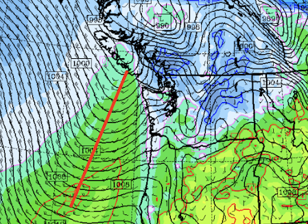
Here is the analysis (truth) for sea level pressure (solid lines) and low-level temperatures (colors) for 4 AM on 24 February.


The 144-hour (6 day) forecast has some noticeable issues, such as the low off the California coast being radically weakened.    The big high offshore is in both.


Strangely enough, the low is back in the 180 hr (7-day) forecast, but too far offshore.


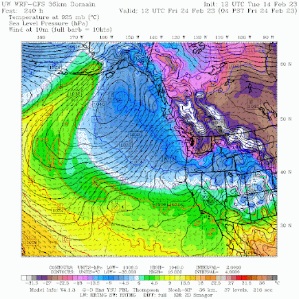
In contrast, the 240 hr (10-day forecast) has the high-pressure area hugely in error and shifted northward, and cold air (blue) flooding the northeast Pacific.    Not good.


I generally don't trust forecasts beyond 7-8 days unless the ensembles of multiple forecasts are on the same page.

To listen to my podcast, use the link below or access it through your favorite podcast service.


Some major podcast servers:

 HTML tutorial HTML tutorial
Like the podcast? Support on Patreon 


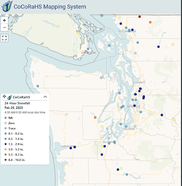
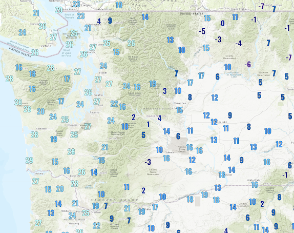
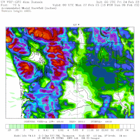
PS:   Here are the snow totals for last night.  There was some snow everywhere but measurable snowfall was mainly north of Seattle.  In most locations, it melted rapidly after it fell.


February 27, 2023

Update on Tuesday's Snow Event

 We can still expect to see lowland snow tomorrow, and being closer in time, I have powerful additional forecasting tools to apply.

But before I do so, let me note that there was a magnificent auroral display last night, mostly behind the clouds, and during some openings, the sky was aflame.

Here is an image from North Kitsap, provided by weather cam maestro Greg Johnson of Skunk Bay Weather.  Stunning.


Back to snow.   

This is late season for western Washington/Oregon snow and temperatures are marginal.  But with sufficient precipitation intensity, melting and evaporation can drive the snow level down to the surface.   The result:  wet snow.

The latest forecasts are converging on around 2 inches near sea level, but as we will see, there will be considerable variability.

The feature of interest is a low center (and associated fronts) that is centered off the Oregon/Washington coast right now (see image).  Right now some weak bands of precipitation are over land.  Some light drizzle and snow showers.


That low center will drift to the northwest during the next 24 hr, associated with an approaching upper-level trough of low pressure.  The sea level pressure map at 4 AM tomorrow (Tuesday) is shown to illustrate.


Now, let's examine the forecast model output.

The total snowfall (not snow depth) through 4 PM Tuesday from the uber-resolution UW model is shown below. Perhaps 2 inches in the central Sound, with less over the warmer water.  Similar amounts over Bellingham and the San Juans. Less south of Seattle.


The European Center model, with far less resolution, has a fuzzier but similar forecast.

If I have tried to communicate one idea in this blog, it is that forecasts have uncertainty and meteorologists must define this uncertainty and communicate it.

If only politicians, Covid-forecasters, and some local newspapers did the same.😆

A key tool for defining forecast uncertainty makes use of an ensemble of many, but plausible forecast simulations.    The UW runs one of the best such ensembles in the nation and you can enjoy the fruits of this technology.

For example, here is the ensemble snow forecast for Seattle.  Lines show different forecasts, with the black line being the average of all of them.   
The snow revs up after 10 PM tonight (06/28), with considerable uncertainty.  The average total snowfall is about 2 inches.  

Olympia?  Some snow this AM and they end up with about 3 inches by tomorrow afternoon.

Portland should get about 1.5 inches. 
The European Center has a lower-resolution ensemble.  For Seattle, it suggests about 3-4 inches.


So plan for snow overnight into tomorrow morning.  And with above-freezing temperatures, no ice should bond to the surface.  And it will warm up tomorrow afternoon with onshore flow behind the low.


February 26, 2023

More Snow is Ahead for the Pacific Northwest

 Special Message:

  Could be a major aurora tonight (Sunday) for our region.   Lots of clouds right now, but there should be some clearing in a few hours in western WA.

--------------------

The snow forecast went quite well this morning over western Washington, with portions of central Puget Sound picking up the predicted 1-2 inches (see observed snowfall noted this morning by the CoCoRahs cooperative network).  


This was a very difficult forecast, with marginal temperatures.   The kind of forecast we could not have done 15-20 years ago.

But there is a downside to this increased forecast skill, a negative impact that directly affected me this morning (see below).  I was REALLY looking forward to a pastry and cup of coffee before I went to work at the UW.   No luck.


Another snow event for western Washington looms.....and another difficult forecast.

Why difficult?  Because major weather prediction models were in disagreement about a crucial weather feature, and we are close to the edge regarding temperatures over western Washington and Oregon.

There have been subtle differences in the location of a low-pressure trough along the Washington/Oregon Coast that influences precipitation, and thus snow, over western Washington.

The European Center was going for more snow over central Puget Sound, but now the latest U.S. GFS model simulation (initialized 6-hr later) has joined in the snowy fun.

Below are the forecast accumulated snowfall totals for both models through 4 PM Tuesday.

The European Center shows over 3 inches for Seattle and Portland, except right near the water.

The updated U.S. GFS model is similar but with more snow over the lowlands.  The mountains get hammered in both.


When will the snow arrive? Tuesday morning.

The European Center is quite confident snow is in our future.  Below are the cumulative snowfall totals in Seattle from the large and excellent EC ensemble system of many forecasts.  Each line represents a different forecast run.  Virtually every run turns blue (snow).  Purple is even more.

The average of the ensemble forecasts for Seattle snow is shown below (light blue bars)--around 5 inches of snowfall is predicted.  The solid line is a single higher-resolution prediction....even more.


Tomorrow I will provide more details based on higher-resolution local simulations.

One final note:  I ask that no one tells the Grand Central Bakery about the forecast.  The reasons are obvious.


February 25, 2023

A Snowy Period Ahead for the Pacific Northwest

 We are currently at the end of the normal lowland snow period in the Pacific Northwest, with the sun rapidly strengthening.   

But not this year.  

The latest forecasts have significant lowland snow over western Washington during the next few days, with many of you experiencing several inches of the white stuff.

And we have an extended, colder-than-normal period ahead.  

Let me give you the details of the forecast.

Today, we have a cold air mass over the region...cold enough to snow anywhere in Washington State.  Temperatures dropped into the teens and twenties in western Washington and single digits in eastern Washington (see low temperatures below).  Several daily low-temperate records fell last night.


This evening a moist occluded front will approach, spreading precipitation over the region.   Snow will move into the Puget Sound region after 8 PM.

Note that the story in the Seattle Times is very wrong, suggesting snow will come in this afternoon around 4 PM.  It also talks about an influx of Fraser River cold air later today.  Simply not correct.

Let me show you the cumulative snowfall totals over Seattle from the most powerful forecast tool available:  an ensemble of many high-resolution weather predictions, each slightly different. (Time is in UTC, 06Z/26 is 10 PM tonight).  A rapid start of the snow around 9 PM.  The black line is the ensemble average....generally a very good forecast.  Just under 1.5 inches.  And it is all over by around 3 AM.


The distribution of snow will be quite varied, so let me show you the accumulated snowfall through 10 AM Sunday (below).

Little snow near the Strait of Juan de Fuca and right on the Pacific Coast.   A Puget Sound convergence zone feature will increase snow east of the Olympics.  Lots of snow in the mountains and a good snow area in eastern Washington east of the Columbia River.  More snow east of Seattle than in the city.

Temperatures will be on the edge for snow.  It will be wet snow and there will be less snow near the water. Note that snow depth will be less than snowfall.  Snow melts and compacts at the surface.


Temperatures will warm into the lower 40s on Sunday (again stronger sun, plus onshore flow after the front).  Thus, I expect the roads to rapidly melt out.

But we are not done with snow.  

On Monday, a low-pressure center will approach the southwest Washington coast, drawing cold air back into the lowlands from the interior.   This low (and associated upper-level trough) will bring more snow into the region, first in western Oregon and then in western Washington.


The 24-h snowfall ending 4PM Monday shows substantial snow over the coastal areas and southwest Washington.  Portland gets several inches.


And then in the next 24-h (ending 4 PM Tuesday),  Puget Sound and Seattle get several more inches.


And folks, this is not the end of the snow threat. 😀

The latest 8-14 day temperature outlook from the NOAA/NWS Climate Prediction Center is enough to make you want to lay in a supply of thermal underwear and hot chocolate.


And if you think what is happening here is unusual, the cold, snow, rain, and winds in California are extraordinary and record-breaking for this time of the year.

February 23, 2023

Wet Snow on Sunday Morning over the western lowlands, and a major forecast bust in Portland.

 Frigid air has settled over the region, with the low temperatures today ranging from the mid-20s over the western lowlands to the teens and single digits in the Columbia Basin (see below).   Temperatures dropped to below zero F over some valleys east of the Cascade crest.


The whole region is plenty cold enough for snow right now, there just isn't any moisture.

All the moisture is going into California right now.   Good...they need it!

Friday and Saturday will be generally dry over the Northwest, with plenty of sun.

But Saturday night, a moisture source will approach:  a Pacific occluded front (see forecast map for 7 PM Saturday night, black lines are sea-level pressure, the front shown by a red line, the near-surface temperature in color shades).


The front will bring moisture and warming, but the latest model simulations suggest that cold air will hold in enough in central Puget Sound to produce a few inches of wet snow on Sunday morning (see UW model forecast accumulated snowfall through 4 PM Sunday).

Lots of snow in the mountains.


With temperatures on the edge, expect less snow near Puget Sound.

The European Center model is going for less snow near the Sound...around an inch.


The Portland Forecast Bust

As good as weather prediction has become, sometimes the results disappoint.  

And forecast skill is rarely more problematic than for Northwest snow.  Not only are temperatures often marginal for snow, but small errors in precipitation intensity can have HUGE impacts on snow forecasts.

Keep in mind that a tenth of an inch of precipitation in the form of water will result in roughly ONE inch of snow.  A roughly ten-to-one ratio.    So small errors are amplified.

Here are the snow totals from yesterday in the Portland area.  Around 8-10 inches around the city.


In fact, Portland's airport received 10.8 inches, resulting in the second snowiest day in the station's history.

How much was predicted?  The official National Weather Service forecast Tuesday night was less than an inch! (see below)


A major issue was that the models underplayed the moisture circulating around a low moving down the coast, with a band of heavier precipitation hanging around Portland (see satellite image around 3 PM yesterday).  Hard forecast.


February 22, 2023

The Unimaginable Predicted: Snow in San Francisco

 When one thinks of San Francisco weather one generally does not think of snow, but the latest model runs are going for flakes falling around the city.

For example, the European Center's model accumulated snowfall forecast through 10 AM Friday has substantial snow on the hills around San Francisco, with snowflakes reaching the Airport.   

The U.S. GFS model has even more...snowflakes over the entire city!


Forecast temperatures for 4 PM Thursday are 15-25F below normal (see European Center Forecasts below).

The media is going crazy with this snow talk for the "City by the Bay", warning of "wintry blasts".   Highly dangerous conditions for the city's large homeless population.


How unusual is snow at the airport in San Francisco?  As shown below, measurable snow only occurred there ONCE--in January 1962.

Huge snowfall totals are expected during the next week over California during the next five days (see forecast below). Yards of snow. And deep snow will even fall in the mountains of SOUTHERN California.  Every California reservoir should be able to fill.

And a major snow event may occur over western WA on Sunday.  But that will be discussed in another blog!


February 20, 2023

Light Arctic Front Snow for Western Washington.

 In a paper I wrote several years ago on western Washington snowstorms, I list several ways snow can fall in the area.

All had to find a way to provide precipitation and cold at the same time--which is very difficult in our neck of the woods.

One way to get snow...generally light snow.. is with the passage of an Arctic Front (really a modified Arctic Front, but who is checking?)

And we are going to get some snow from such an Arctic Front passage on late Tuesday and on Wednesday morning.


In a western Washington Arctic Front passage, cold air from the interior of British Columbia surges southwestward through the Fraser River Valley and jets out just north of Bellingham.  The frigid flow splits around the Olympics with a river of cold air pushing southwards over Puget Sound.

The Arctic air collides with warmer/moist air to the south, pushing some of it upwards producing clouds, precipitation, and yes, snow.


Later tomorrow, the Arctic air will push southward, as illustrated by the forecast surface winds at 10PM Tuesday shown below.


A band of snow will form at its leading edge, as shown by the forecast  3-hr snowfall total ending at 7 PM tomorrow.


The predicted snowfall total (NOT SNOW DEPTH) Thursday morning shows .5 to 1 inch from south Seattle northwards, with more on the east side.   Much more snow in the mountains   A band of snow will also occur upstream of the blocking Olympics.


I don't want to hype this....not the end of the world.  But many of you around Puget Sound will see some flakes.   There is more snow over SW Washington, where they will get some precipitation from a weak low along the northern Oregon Coast.

The mornings the next few days will be cold....well below freezing, so be prepared.  

And talking about being prepared, some big swell will be approaching our coast tomorrow and Wednesday as well, with some waves above 20 ft.  Strong northwesterly winds with a large fetch are a big contributor.  Between the waves and the cold, not a particularly good time for cruising.


Should I Let AI Write My Blogs?

I spend a lot of time thinking about and writing my blogs.   Could AI apps do the work for me?   Could any of you tell the difference? Well,...