September 30, 2020

Smoke and the Reddened Sun is Back

Last night, as the sun was setting on the Olympics, the approaching California smoke was apparent.

And this morning, the sun, obscured behind the spreading smoke veil, reddened the sky while fog threatened to engulf the city.  Beautiful, really.

The visible satellite image at 9:46 AM clearly showed the smoke over western Washington and the conduit of smoke stretching back to northern CA.


Fortunately for those of us who enjoy breathing, the bulk of the smoke stayed aloft, something often true of smoke imported from afar.   Air quality sensors at the ground show degradation along the Oregon coast and, to a lesser degree, in western Washington where some air quality sites have declines to "moderate" levels of small smoke particles.


For example, in Seattle (below), small particle concentrations have increased from typical background levels (around 5 micrograms per cubic meter for PM2.5 particles) to around 25.  Most people will not notice this level of smoke.


The biggest protection we have from the overlaying smoke is the inversion layer near the surface, where temperature is increasing with height.  Inversions suppress vertical motion of air.

The vertical sounding at the WA coast this morning, produced by weather instruments lofted by a weather balloon, showed the inversion clearly (see below).  Temperature values are noted on the x axis, height (in pressure) on the y-axis.  850 is about 5000 ft.  Temperature (the right solid line) increases with height to about 950 hPa...about 2000 ft above sea level.


Air does not like to mix through inversions, but as temperature at the surface increases, the inversion will weakening. Model forecasts suggest that enough of the inversion will remain to prevent large amounts of smoke from reaching the surface.  Just a gradual, modest degradation over the day.

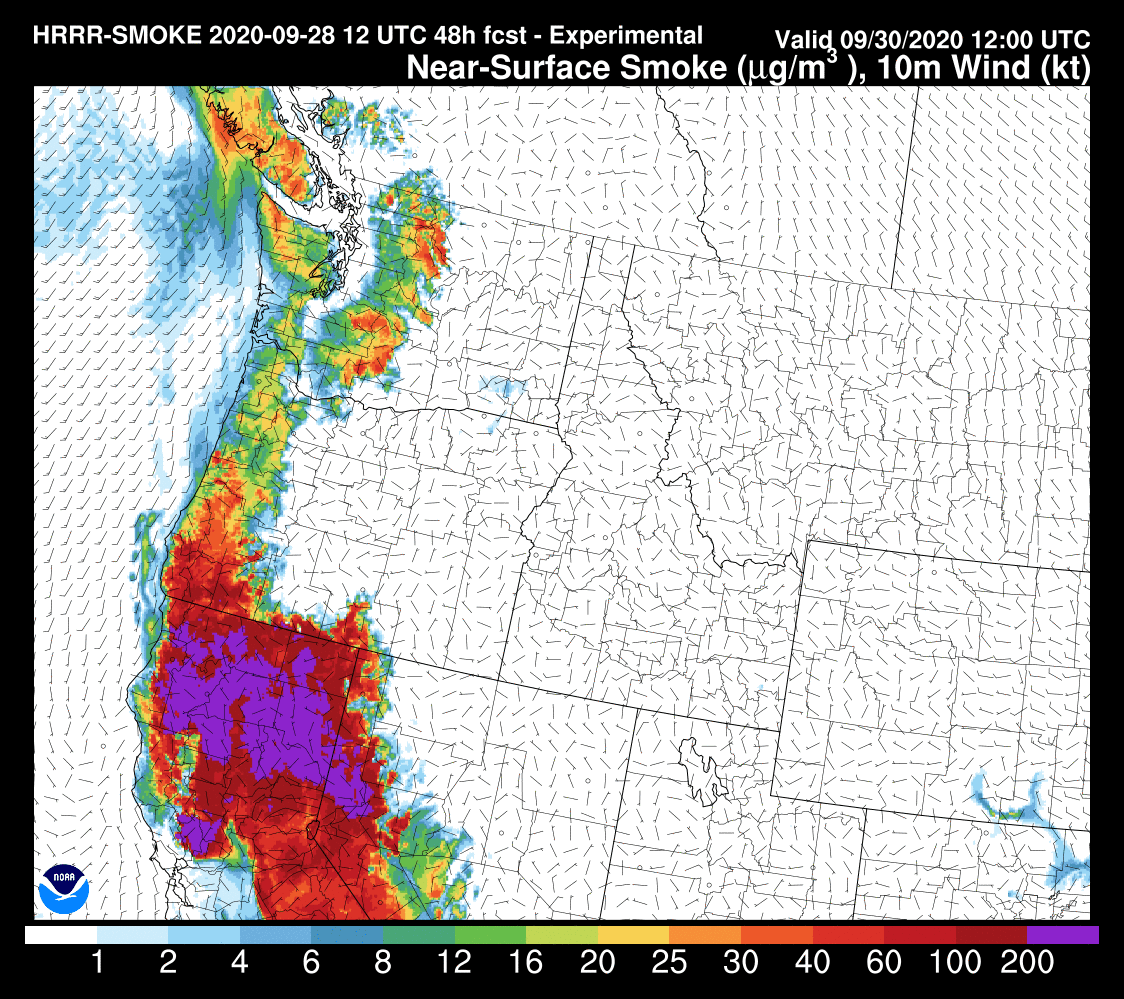
The general weather pattern is not shifting much during the next day, so light smoke should remain for awhile.

I should note that the smoke can be traced to northern California where a Diablo wind event occurred over the weekend.  In such events, strong/dry northeasterly winds develop over the region that can start and spread fires, with Diablo winds driven by high pressure east of the Sierra Nevada.  Fortunately, the Diablo winds have declined, and northern CA smoke production has lessened (see satellite picture this AM below).


On Sunday, winds will switch to northerly over our Northwest and remove the smoke.

______________________________________


Want to support the creation of the blog and podcast? 

KNKX and Cancel Culture is found here.

September 29, 2020

Smoke is Approaching and Will Settle In Tomorrow over Washington State

 An unwanted California import is now approaching and on satellite photos its ominous tendrils are reminiscent of dementors and deadly hallows of Harry Potter fame.

A recent (11 AM)  visible satellite image is worrisome (see below), with northward-bound smoke from California now extending over most of the Oregon coast and starting to extend above the southern Willamette Valley.


The latest available NOAA HRRRsmoke forecast show the smoke rapidly moving north and west.    Starting with the total smoke aloft, by 11 PM tonight smoke--some dense--will be over western Washington (purple and red signify the greatest concentrations)


And by 11 AM Wednesday will be across all of Washington State.


And at 11 PM Wednesday, a fresh batch of smoke will be moving northward out of California.

The greatest concentrations of smoke will remain aloft over western WA, but some will reach the surface here in Puget Sound.  To illustrate, let me show you the predicted smoke in an east-west vertical cross section across Puget Sound (the valley between the two mountain ranges in the cross section).

At 10 PM tonight, smoke, some of it dense, will be above Puget Sound at elevations of roughly 10,000 to 20,000 ft.  The moon will be obscured a bit.


11 AM Wednesday morning will see the smoke layer lowered  with modest concentrations of smoke reaching the surface.   Probably not enough to be hazardous, but some sensitive folks might notice it.


And smoke sticks around at low levels through 11 PM tomorrow (Wednesday), with modest concentrations at the surface.  This is nothing like our last smoky period, but skies will be hazy.


Unfortunately, the atmospheric pattern, bringing smoke up from California, will continue through Thursday.

___________________________________________
My 101 Class

As I have mentioned before, I am teaching Atmospheric Sciences 101, an introduction to weather and climate, this fall.  Not surprisingly, it will have to be online (Zoom).    But perhaps this is a rare opportunity as well.

As you know from this blog, I am really into outreach to the community through my blog and podcast (and previously my radio segment on KNKX).   I would like to try doing outreach this quarter with the online 101.

If you are over 60, you can sign up for the wonderful UW Access program, where for only a few dollars (I believe 5), you can audit UW classes.   So I encourage all of those interested in taking the class to do so.  Access students can't register until the third day of class, but I can give them the zoom address.

The class meets M-TH at 9:30 AM starting this Wednesday (Sept. 30th).  The class outline is here.
_______________________________________________

My latest podcast:


If you would like to support the creation of the podcast, please visit my Patreon site
KNKX and Cancel Culture is found here.


September 28, 2020

Smoke is Coming Back to the Pacific Northwest

I am really sorry to be the messenger for ill news.

But smoke is coming back to the Northwest later tomorrow and will be with us for several days.

California smoke.

Our skies will become hazy, the sun will take on that infernal reddish glow, and visibility will decline.

The only good thing is that most of smoke will stay aloft, but limited amounts will get to the surface in "favored areas."

The latest visible satellite image (1PM Monday) shows the problem:  massive fires are still burning over central/northern California and producing enormous amounts of smoke are being produced. Right now the smoke is blowing due west into the Pacific.  That is about to change.


The forecast weather map for roughly 5000 ft above the surface (850 hPa pressure) at 5 PM Tuesday, shows the evolving atmospheric configuration, with low pressure offshore and high pressure centered over Idaho.  This pattern will produce southerly (from the south) winds in the lower to middle atmosphere.   Winds that will pull the smoke right over our region.


Now, let me show you a recent forecast by the NOAA HRRR smoke model. Gird yourself. I will start by showing you the total smoke aloft.  

5 PM today (Monday).  Smoke over California and the offshore waters.  Where it belongs!  (purple is the worst,  followed by red, orange, and yellow)


By 5 PM tomorrow (Tuesday) the smoke has pushed northward up the Oregon coast and will just be entering southwest Washington.  Just in time for the big presidential debate!


And by 11 PM tomorrow (Tuesday), the smoke will be over western Washington in force as well as over the Oregon coast.


And the smoke will continue to move eastward over Washington State overnight.  Wednesday morning will dawn with smoke in western Washington.

Fortunately, the majority of the smoke will be above the surface, but the latest HRRR forecast for 5 AM Wednesday shows some smoke reaching the surface, particularly at higher elevations.    More smoke will mix down during the day as the surface heats and surface-based convective mixing brings down some of the smoke.  Northern California will have hazardous air quality.  Really bad.


Just for fun, I traced back the air over Seattle at 5 AM Wednesday using the NOAA Hysplit model.  Where did it come from at various levels? (ending at 500, 1500, and 3000 meters above the city).  

The answer is found below.  At 3000 meters (about 10,000 ft), where do you think the air over Seattle came from? DIRECTLY OVER THE FIRES.  No wonder we have a smoky problem ahead.    At low levels, the air is from eastern Oregon, where the air quality is now pretty decent.


Anyway,  we will have several days of high-level smoke ahead.  So enjoy the blue skies today and tomorrow.    

Much of the smoke will move in over Seattle during and immediately after the Presidential debate.  Whether there is a deep metaphor in this coincidence is something that I will leave to others to explore. 

___________________________________________
KNKX and Cancel Culture is found here.

My 101 Class

As I have mentioned before, I am teaching Atmospheric Sciences 101, an introduction to weather and climate, this fall.  Not surprisingly, it will have to be online (Zoom).    But perhaps this is a rare opportunity as well.

As you know from this blog, I am really into outreach to the community through my blog and podcast (and previously my radio segment on KNKX).   I would like to try doing outreach this quarter with the online 101.

If you are over 60, you can sign up for the wonderful UW Access program, where for only a few dollars (I believe 5), you can audit UW classes.   So I encourage all of those interested in taking the class to do so.  Access students can't register until the third day of class, but I can give them the zoom address.

The class meets M-TH at 9:30 AM starting this Wednesday (Sept. 30th).  The class outline is here.
_______________________________________________

September 27, 2020

Bird Migration Alert, Huge Ridge Ahead, and my 101 Course

Last night I was outside and I heard large numbers of unseen birds overhead.  It is that time of the year.

In fact, there is now a bird migration alert for our region, as provided by the wonderful Birdcast website.  Such migrations can now be tracked with weather radar in high-sensitivity (non-precipitation) mode.


The Birdcast migration map last night (3:50 AM PDT) showed active southward bird migration over the western U.S., with the arrows showing migration direction and the shading the migration magnitude.   Much of Washington State is yellow, which means lots of our bird friends aloft.


Turning to our local weather radar, here are the radar echoes at 3 AM this morning.  With no rain, this is all birds.  Wow.   The green colors show very large bird concentrations.  Notice how birds don't like to fly far offshore.  You can also see where we have radar gaps over land (eastern slopes of the north Cascades)


My general impression was that the birds did not like smoke.  But now with clear skies and northwesterly winds aloft, this is an excellent time to fly south.  Birds are smart.
_______________________________________________

Another major weather story is the HUGE ridge of high pressure that will develop over our region, resulting in dry conditions and warming to well above normal (as high as 80F in some locations) during the next few days.   Let me show you!

Today at 5 PM, the upper level charr (500 hPa pressure, about 18,000 ft) shows a major ridge (H) over the West Coast.  Think of the lines as pressure at 18,000 ft.  Note the intense low over the Gulf of Alaska.

On Tuesday at 5 PM, the ridge amplifies and extends northward.  Good time to enjoy a meal at an outdoor restaurant--you will be quite comfortable, with sun and temps in the 70s.


Thursday at 5 PM.  Same thing.   While we enjoy sunny, warm weather, the Gulf of Alaska is going to be hit by intense, ferocious storms


The latest  surface temperature forecasts for Seattle from the European Center indicate perfect weather ahead, with highs rising into the 70s for the entire week.  No rain.   And because of the heavy rain of the past week, the chances of new wildfires are very, very low.  In addition, we do not expect strong easterly winds.  So air quality for most of the region should be good.


___________________________________________

My 101 Class

As I have mentioned before, I am teaching Atmospheric Sciences 101, an introduction to weather and climate, this fall.  Not surprisingly, it will have to be online (Zoom).    But perhaps this is a rare opportunity as well.

As you know from this blog, I am really into outreach to the community through my blog and podcast (and previously my radio segment on KNKX).   I would like to try doing outreach this quarter with the online 101.

If you are over 60, you can sign up for the wonderful UW Access program, where for only a few dollars (I believe 5), you can audit UW classes.   So I encourage all of those interested in taking the class to do so.  Access students can't register until the third day of class, but I can give them the zoom address.

The class meets M-TH at 9:30 AM starting this Wednesday (Sept. 30th).  The class outline is here.
_______________________________________________


My latest podcast:

September 25, 2020

New Podcast on the Latest Forecast and Atmospheric RIvers


Click the play button to listen

Episode Description

In this podcast, I talk about the heavy rain this morning, the improvement over the weekend (Sunday will be the best day), and the major ridge of high pressure that will bring warmth and dry conditions.  Yes...even to 80F in western WA.  Then I give you a tutorial about atmospheric rivers, a fascinating phenomenon that can bring heavy rain and flooding to our region.

Stream the podcast from your favorite services:


Coming Next Week

In my next podcast I will probably talk about climate change in the Northwest.
And I plan a major blog on my situation with KNKX (some background information here) and discuss why they rejected key foundations of freedom of speech and diversity of viewpoint that are critical for maintaining our democracy.

If you would like to support the creation of the podcast, please visit my Patreon site

Should I Let AI Write My Blogs?

I spend a lot of time thinking about and writing my blogs.   Could AI apps do the work for me?   Could any of you tell the difference? Well,...