November 30, 2022

A Triumph of Weather Technology, the Next Snow Events, and Power/Airport Problems

Weather prediction technology has come a huge way over the past decades and yesterday's localized snow event is a great example of how far we have come.

The most difficult Northwest forecasting problem is snow prediction.

And there is no harder snow problem than a situation marginal for snow and where there are very localized weather effects.

Yesterday (Tuesday) was such a difficult snow situation and the high-resolution models did very well.

The Forecast

As I described in this blog, cold air was in place and an approaching frontal system brought general very light snow, with heavier snow over North Seattle and Snohomish counties.  The models also predicted heavy snow in the Cascades, including its lower western slopes.

Below is the high-resolution WRF model forecast of snowfall through 4 AM today (Wednesday) made 4 PM Monday.

Light snow from downtown through Tacoma (about 3/4 inch), with heavier snowfall (peaking at 5-7 inches) from Lynwood to Everett.  Heavy snow in the mountains.


Huge spatial variations.   The NWS put out of map with snow reports (see below--with a few additions I put on).    The forecast was very, very good.


We simply could not have done anything like this 20 years ago.  And this success is not a one-off.  Remember the big heat wave in June 2021?  We correctly forecast record-breaking temperatures days before.  I could give you a dozen other examples of great success.

Improved weather prediction allows society to deal with extreme and unusual weather in a way impossible only a few years ago.

The Problem

Society needs to recognize and use these improved forecasts.  Case in point: Seattle Tacoma Airport yesterday.  To put it mildly, it was bedlam.  Less than an inch of snow resulted in dozens of cancellations and flights delayed for 1-3 hours.  The situation was particularly bad for Alaska Airlines, which lacked sufficient deicing capabilities.   


The potential for light snow was in the forecast and temperatures were not that cold (just near freezing) that morning.  The snow reached the airport around 7:45 AM.  Someone from Alaska Airlines told me the issue was that a lot of planes were sitting around on the tarmac overnight and they did not have the hanger capacity to keep them under cover.

How about this suggestion?   Put large tarps over all the wings and critical surfaces for planes on the ground during such rare situations?  Tarps are cheap.  

And then there were the massive power outages from wet snow on branches.  Local utilities need to put far more emphasis on vegetation management around their powerlines.  Seattle City Light's major outages were in the northern (snowy) side of the city (see below)


The Next Event

More snow and cold are coming to our region, and the snow distribution should be very different. Most of the lowland snow action will be to the south.  

Here are the 24 h snowfall totals ending 4 PM Thursday.  Snow from Olympia or Tacoma south.    Snow over SW Washington and the southern Cascades as well as a good swath of eastern WA.  

There is some uncertainty to the northern edge of the snowband...keep that in mind


But WAIT! The snow possibilities don't end there!  ANOTHER low center will move offshore Friday afternoon with another front approaching Friday night (see sea level pressure forecast, with low-level temperatures, for 4 PM Friday.


This might bring a burst of light snow to Puget Sound country overnight (Friday/Saturday), with more snow to the mountain (see 24h snowfall ending 4AM Saturday)


Someone should drop off some big tarps at SeaTac Airport for our friends at Alaska Airlines.

November 29, 2022

Light Snow this Morning and the Warm Up Overnight. Plus, Strong Winds and Another Snow Threat....

As expected, some light snow came in this morning....a dusting for most and as much as .5-1 inches for favored locations (see below).  The roads were warm enough and the air temperatures marginal enough that the snow rapidly melted on most roadway surfaces. 

Ironically, the snow is associated with warming aloft.


The weather radar this morning around 11 AM  showed very light precipitation over the region (blue colors), with heavier precipitation offshore).


Warm air is streaming in aloft as shown by temperature sensors on aircraft taking off and leaving Seattle.  And surface temperatures are being warmed by the (weak) sun.   Don't expect any low-level snow accumulation during the day.

This warm air aloft is leading a surface warm front, which will get to the coast around 6 PM, with a cold front a few hours behind.

So there will be a few light flakes in the air today, but nothing that will be substantial.

As precipitation increases on the coast later this afternoon, the higher intensity will drive down the snow level and produce some snow around the Olympics (see 3-h totals ending 4 PM below:  rain is black and gray, snow in color).  The Kitsap will be favored as southeasterly flow rises on the eastern slopes. Rain on the coast at that time.


And then a burst of wet snow from Lynnwood to Everett around 10 PM as the frontal moves through and warm air moves in (see below).  It will all melt overnight.    And it will seem warm when you wake up tomorrow.


Disappointed?   Would you be interested in hurricane-force winds?   

Then head to NW Washington this evening.  The approaching front, interacting with the Olympic Mountains, will produce powerful southeasterly winds over Northwest Washington (see gust forecast for 7 PM tonight below).

If you take the Victoria Clipper tonight, bring your sickness bag...

Finally, I am watching the next interesting situation.  By 10 PM Wednesday ANOTHER low-pressure center will move down the coast to NW Oregon, drawing in cool air over the region again (see below).


A little too far south to bring snow to Seattle and NW Washington, but Portland and SW Washington could get some white action.  Will watch it....


November 28, 2022

It Will Snow over Central/Northern Puget Sound But It Won't Last Long

I will have an update at noon....  Some light snow showers are over western WA right now....

__________________________

The most powerful high-resolution meteorological tools are now available for the snow event tomorrow night.   Parts of the lowlands will get snow--up to several inches in places.

But it won't last.

And the situation tomorrow is not a good one for accumulating lowland snow in our region.

The Golden Rule of Snow

Snowfall is NOT snow depth.  

This is going to be very important for the upcoming event.   And this subtlety is often missing from the analyses of some amateur weather websites.

A key issue is the temperature of the ground and particularly roadway surfaces.  Below are this morning's values from the city of Seattle's Snowwatch website, with the temperatures in the boxes showing the roadway surface temperature.   Most are in the upper 30s to near 40F.


The air above us right now has a freezing level of about 1300 ft (see below from SnowWatch below for SeaTac Airport).  Snow melts below that level,  taking about 1000 ft to reach the snow level, beneath which it is all rain.  So the current snow level is about 300 ft.

 
With showers moving through this morning, some of the higher hills in the region got some snow (see below).  And the Cascade passes have been hit hard, with chains required at Stevens Pass right now.

Around 1000 ft ASL in Bellevue.  Picture courtesy of Dr. Peter Benda

Tomorrow's Snow Event

    As noted in my previous blog, a front will approach our region tomorrow afternoon and evening, bringing precipitation.  Cool air will be in place.... just on the edge for being cool enough to allow snow to reach sea level.

But there is something else that will come into play.  Cooling by melting and evaporation.

As precipitation falls into drier air below, it can cool by evaporation, helping to drive the snow level to the surface.   Snow falling into above-freezing air also melts...and that takes energy.   The result is even more cooling, with the amount of cooling dependent on precipitation intensity.

On the other side, warm ocean air will be moving in behind the front!

Now that you are all trained up....let me show you some graphics I rarely present on this blog: forecast precipitation maps that show whether the precipitation reaching the surface is rain (black and gray shades) or snow (colors).

And to make it even better, these forecasts are from the highest-resolution UW system (1.3 km grid spacing).

First, here is the forecast for the 3-h total precipitation ending at 4 PM Tuesday.  Snow around the Olympics Peninsula, but heavy rain offshore and light rain over the interior.


For the 3 hr ending 10 PM Tuesday, the rain (and strong southerly winds have reached the coast), while snow intensifies over the Olympics and the Kitsap Peninsula, where southeasterly upslope flow intensifies the precipitation.  Some light snow from Seattle downtown northward.


The next three hours (ending at 1 AM) are the center of the snow fun for northern Puget Sound (see below).  The higher elevations from Lynnwood to Everett could get several inches of snowfall (NOT SNOW DEPTH).

But note the rain (black colors and gray) rapidly moving in from the south.


Depressingly,  the same graphic ending 7 AM shows rain sweeping in over the lowlands, but snow continuing at higher elevations.


The 24-h snowfall total ending 4 AM Wednesday shows the snow north of Seattle and Kitsap.


The snow depths (in metric units...sorry) at 4 AM Wednesday are far less impressive, with only limited lowland areas getting to .1 meter (3.7 inches)....and that would be rapidly melting at the time.


I told my class that I was pretty certain Wednesday would not be a snow day at the UW.  A very good event for skiers though....


November 27, 2022

Update on the Cold and Snow

 We are much closer to the potential events this week:  close enough in time to have the higher-resolution models available.

As I will explain, the upcoming situation has the potential for lowland snow but is not optimal.  Heavy snow in the mountains is a sure thing.

The SnowTrick

Let me remind you, it is hard to get lowland snow west of Cascade crest.  Moist air coming off the Pacific is too warm for lowland snow, and it is difficult for cold air in the continental region to reach us because of the blocking effects of the Rockies and Cascades.

So to get snow we need something exotic to occur.   The most popular trick is to get a low center off the southern Washington coast and cold high pressure over the BC interior. The difference in pressure causes cold air to be drawn southwestward through the Fraser River Valley or across low terrain into NW Washington, which then spreads southward.  The low on the Washington coast and an accompanying upper-level trough of low-pressure results in rising air that produces precipitation that falls into the cold air near the surface.

That can lead to snow.


The other way to secure lowland snow is to have cold air in place (from the above), while a front pushes inland.  Precipitation starts as snow and then turns to rain.  

We may get a bit of both this week.

The Current Situation

Last night a relatively strong cold front moved through and temperatures aloft  (and near the surface) have fallen substantially.   

The cold front also produced a surge of strong northwesterly winds in the Strait of Juan de Fuca and downstream around Everet, producing wind gusts as strong as 50-60 mph last night (see a plot of gusts below).  A few thousand customers lost power.


Tonight, a weak low will move over western Washington, and cold, high pressure will build into British Columbia (see forecast surface map for 4 AM Monday).  Blue colors are cold enough for snow by the way.  Monday morning will bring a hard freeze to western Washington will lows in the 20s.


Cold, unstable air will be moving into the Cascades during the next day, with some snow accumulation in the mountains (see total snowfall through 4 PM Tuesday below)


The Wednesday Situation

The big action will potentially occur on Wednesday.  A strong upper-level trough will approach, producing preicpitation over the area....where cold air will be in place (upper-level map shown for 4 AM Wednesday)


A  strong surface low will approach northern Vancouver Island, with an associated front making landfall on the Washington coast Wednesday morning (surface map at 1 AM Wednesday is shown).  This front will eventually drag in warmer air, but the precipitation could well start as snow at low levels on Wednesday morning. Large amounts of snow will fall in the mountains.  I


Let me stress that this is not an optimal situation for western WA snow.  For a big snow event, you really want that low to be parked along the southern WA coast, drawing in cold air from BC.

The latest UW high-resolution forecast for snowfall through 3PM Wednesday is shown below.  Many feet in the mountains, but note the band of snow from Seattle to Everett (several inches).  Eastern Washington will get some snow as well.   Snow depth will be less than snowfall, of course.


The lower-resolution European Center model has a similar solution (see total snowfall for the same period..now until 4 PM Wednesday).  Lots of mountain snow, snow over NE Washington, and a band of lowland snow from Seattle to Everett.


Our confidence in the Puget Sound snow forecast will increase as we get closer in time and high-resolution ensembles become available. 


November 25, 2022

Cold Wave Coming to the Northwest with Heavy Mountains Snows. Probable Snow in the Lowlands.

We enjoyed an unusually dry, temperate mid-November, and Thanksgiving Day was a pleasure, but now the brass knuckles of a La Nina winter are about to be revealed.

Cold air and a hard freeze will hit the entire state next week, with massive mountain snowfalls that will delight the ski community.  

All of us should take steps to deal with the upcoming cold, from unscrewing outdoor hoses, and protecting pets, to ensuring that the region's large homeless population is brought inside or protected.

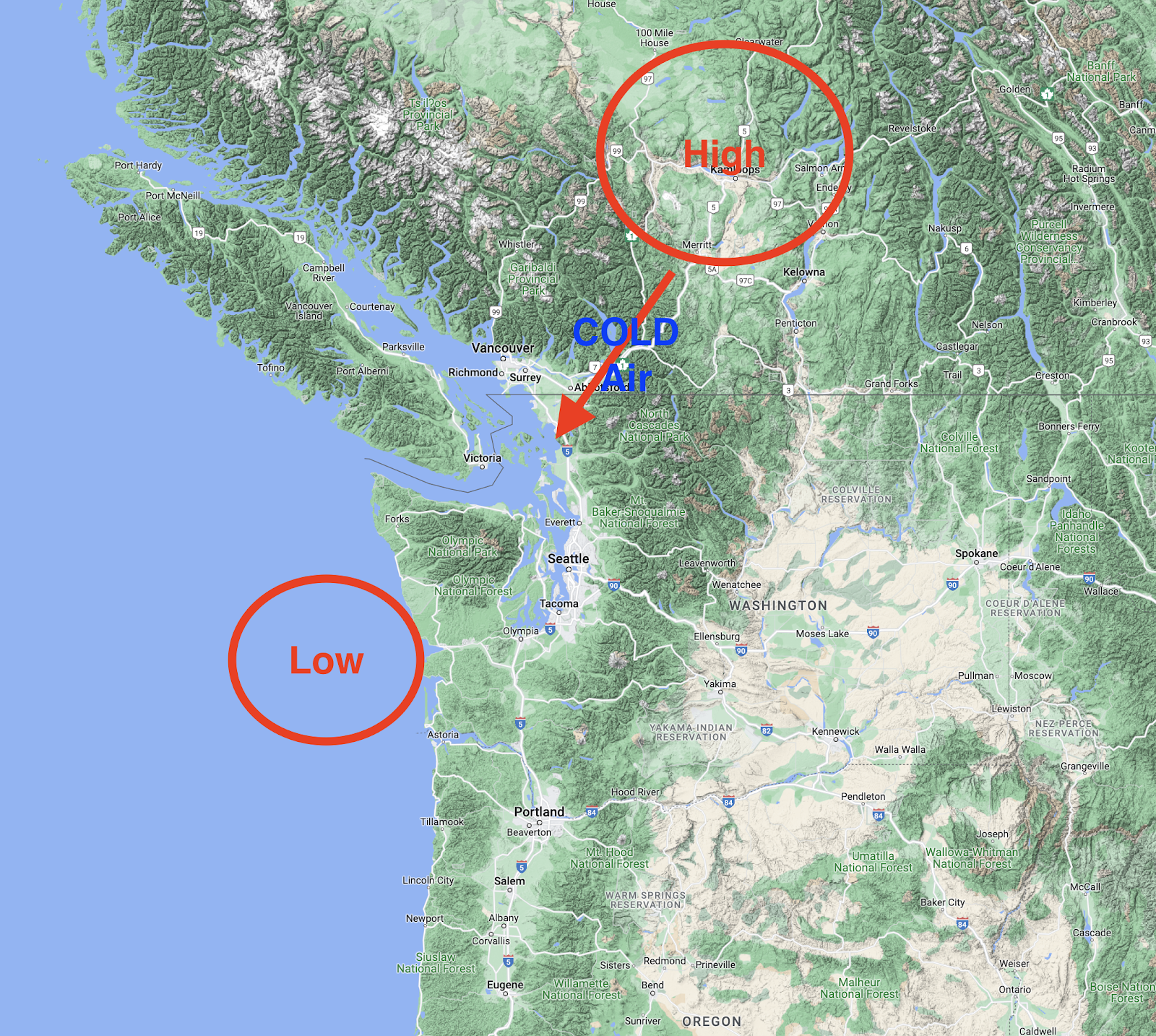
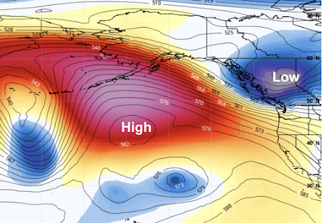
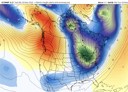
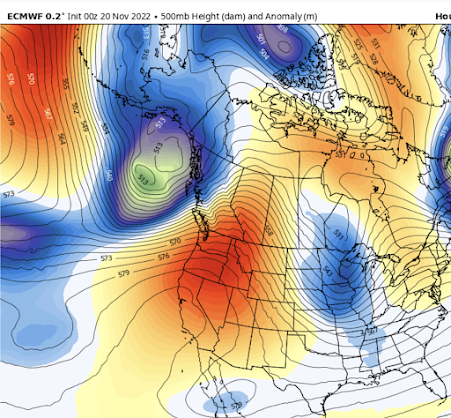
The upcoming situation is a classic for a La Nina winter, in which the central and eastern tropical Pacific is colder than normal.   During such winters, we typically observed a large ridge of high pressure developing over the northeast Pacific, with cool, northerly (from the north) flow on its eastern side (see the forecast upper-level map for Saturday at 10 PM as an illustration).


If there are disturbances in that northerly flow, moving south out of Alaska, we can get bouts of mountain snow, and if these troughs are positioned just right, then lowland snow is possible.

As in any good drama, the action can be separated into several acts.

Act 1:  Initial Cooldown and Mountain Snow.

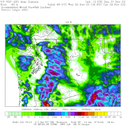
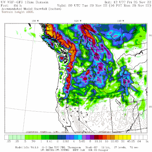
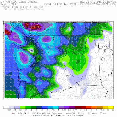
Today (Friday), a cold front is moving through bringing plenty of rain to the region and snow at higher elevations.   On Saturday night and Sunday, a trough of low pressure will move in, producing further cooling and lots of mountain snow.  Take a look at the totals through Monday at 4 PM.    Several feet in the mountains!


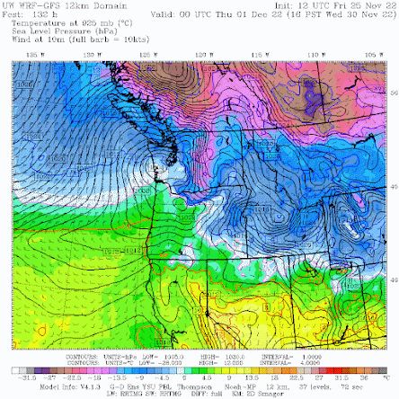
By Tuesday morning, cool air behind the upper-level trough will move into the area (see forecast map for 4 AM Tuesday).  The colors indicate air temperature around 2500 ft.   Blue indicates air cold enough to snow, and purple show frigid, arctic air.    This arctic air is associated with high pressure, resulting in low-level northeasterly winds in the Fraser River valley that will start moving into Bellingham and its vicinity.


Act 2:  A Second Trough, Colder Air, and Potential Lowland Snow

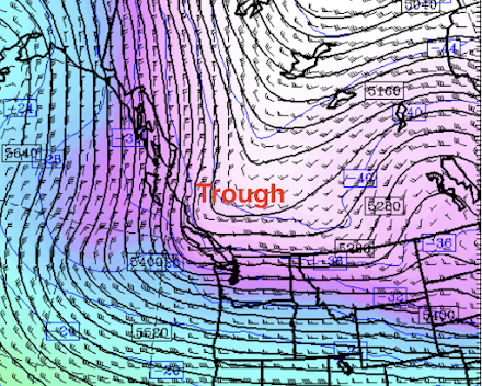
On Wednesday, a second trough will move southward out of SE Alaska (see upper level (500hPa pressure level) forecast below for 10 AM Wednesday). Not perfect for lowland snow west of the Cascades, but close.


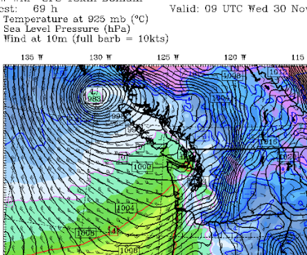
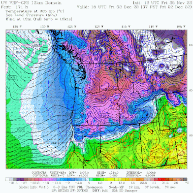
This upper-level trough produces upward motion and precipitation, and will be associated with a surface low center that will move across the central WA coast on Wednesday afternoon (see sea level pressure forecasts, with low-level temperatures below).

This pattern will also draw cold air into northwest WA.


This cold air will then move southward and by Friday morning, the entire region will be cold.   VERY cold east of the Cascade crest.  CRAZY cold east of the Rockies of Montana.


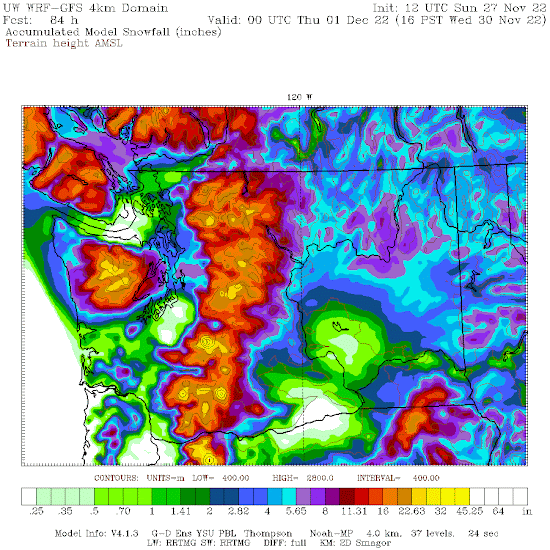
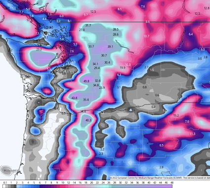
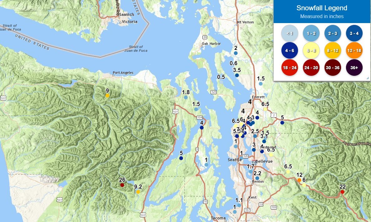
The question will be about precipitation, and thus snow.  The latest UW WRF forecast is producing some lowland snow.  To illustrate here are the 24-h snowfall totals ending at 4 AM Thursday.  Much of the lowlands get several inches.


What about the European Center high-resolution model snow forecast?  It has lowland snow, but about 12-h earlier and further north.   

For an extended forecast with uncertainty, it is wise to look at ensembles of many forecast runs.   Below is the European Center ensemble forecast for snow at SeaTac Airport.  The top panel shows the snow forecasts of each of the 51 different model runs, while the bottom panel shows the snow forecast of the high-resolution forecast (blue line) and the average of the ensemble.

Both high resolution and ensemble prediction are for going for several inches.   But beware of an issue of such ensembles:  the model resolution is low, which tends to increase snow near sea level (since you are smearing the higher snow predictions at greater elevations over the lowlands).


The bottom line:  you can be confident about lots of mountain snow and a major cold period next week.   There is a significant chance of lowland snow in western Washington but substantial uncertainty at this time.   By Monday we should have a very good idea of what will happen.
_______________
No Podcast today...taking a Thanksgiving Break!

November 22, 2022

Climate Tipping Points: Real Threats or Misinformation?

It seems like there is another strident climate "tipping point" headline every other day.  

Threats of irreversible catastrophic climate change just around the corner.

The truth is that such claims by some media outlets and climate activists are contrary to the best science.

An attempt to sow worry and panic, with the motivation to motivate people to "do the right thing."  And it is both unethical and counterproductive.


What is a climate tipping point?  

According to the  Merriam-Webster dictionary, a tipping point is defined as

the critical point in a situation, process, or system beyond which a significant and often unstoppable effect or change takes place

And a climate tipping point can be defined as

 a critical threshold that, when crossed, leads to large and often irreversible changes in the climate system.

Specifically, the idea is that increasing greenhouse gases (like CO2) will result in warming that will produce large, irreversible changes in the climate system.    

Like driving off a cliff.  And that reducing greenhouse gas emissions and concentrations later will not help.  The changes would be irreversible.  We could not go back.


Sounds scary, doesn't it?   

Fortunately, the best science suggests that such tipping points do not threaten the global climate system of our planet. 

Yes, global warming from increasing greenhouse gases is expected.  But the resulting changes in the climate during the next century should be slow and reversible.  None of the many climate simulations driven by large increases in CO2 indicate a tipping point.

Consider a collection of 20 CMIP-5 global climate model simulations, run with CO2 emissions ranging from crazy high (RCP8.5) to more probable (RCP4.5).  As shown below, there is some variability in the warming for each of these warming scenarios, but NONE go up suddenly into uncontrolled warming.  No tipping points.  Other climate simulations suggest the same thing.

What about global warming in the Northwest?  

As part of my research, I have run high-resolution climate models driven by the highly aggressive RCP8.5 scenario.  Looking at a dozen regional simulations, each driven by a different international climate model, there are NO TIPPING POINTS for Seattle temperatures over the next century.   Just a steady rise with some variability around the mean.


What about the IPCC (Intergovernmental Panel on Climate Change),  the most well-known and respected body on global warming and climate change?   

They are emphatic that there is no evidence of imminent (over the next century) tipping points for the Earth's climate.   Let me provide some examples.

The loss of Arctic sea ice?   This is what the IPCC (Special Report on implications of 1.5C or more warming, Chapter 3) says:

"there is little evidence for a tipping point in the transition from perennial to seasonal ice cover. No evidence has been found for irreversibility or tipping points, suggesting that year-round sea ice will return given a suitable climate"

Melting of the arctic permafrost releasing warming methane gas?  No tipping point

"the carbon released to the atmosphere from thawing permafrost is projected to be restricted to 0.09–0.19 Gt C yr–1 at 2°C of global warming and to 0.08–0.16 Gt C yr–1 at 1.5°C, which does not indicate a tipping point"

Heatwaves and heatwave deaths?  This is what the IPCC says

Increases in ambient temperature are linearly related to hospitalizations and deaths once specific thresholds are exceeded (so there is not a tipping point per se).


Global warming is a serious issue but there are no impending cliffs for the global climate.  No imminent tipping points for the global climate.

With that being the case, some climate advocates have gotten creative and are now pushing local tipping points.   One recent paper (Lenton et al., 2019) claims nine local tipping points (see below), including changes in fires and pests in Canada.  Many of these claims are poorly supported by the best science.


Even the Seattle Times has joined the tipping point crowd, claiming that climate change threatens a tipping point for the Western Red Cedar (see below).  As I will discuss in a future blog, this Seattle Times article is full of errors.


Climate Deception

Those pushing climate tipping points are doing the devil's work.   They know that the effects of human-caused climate change are currently relatively modest.   But folks aren't sufficiently motivated to take the actions the activists want.  So they have decided to scare the population, with an impending, terrifying precipice of climate change.

Not ethical, not based on science.  And they are causing folks psychological harm and pushing governments to make poor decisions.


November 20, 2022

One Dry Record Will Be Broken. But Rain is Coming Back

Climatologically, the Northwest is now in the wettest time of the year.   But that is no guarantee of cloudy, dripping skies.

Today will represent the 13th day without measurable rain at Seattle Tacoma Airport (measurable rain is 0.01 inches of rain or more).     

Another sunny day in western Washington and Oregon

And in doing so we tied the record string of 13 dry days in November at SEA that occurred in 2000.

Tomorrow will be dry as well, and thus we will break the November record for consecutive dry days..  

But to deflate your excitement a bit, this only ties the record that crosses over into December (November 20-December 3).

As noted, in earlier blogs, the origin of this dry bounty is a ridge of high pressure over the West Coast (see below), ironically resulting in headlines of cold/wet weather in the western U.S.

Upper level (500 hPa pressure) at 10 PM Saturday night.  Red indicates ridging (high pressure) and green/blue indicates troughing (low pressure).

A front will break through the ridge on Tuesday bringing general rain over the region.  The forecast map below shows the 24-h rainfall ending 4 PM Tuesday.  No more dry records!


And then a miracle occurs.  The ridge rebuilds late Wednesday and Thursday, leading to a dry, sunny Thanksgiving (see below).  You can look forward to an invigorating pre or post-Turkey walk outside and safe travel across the Cascade passes.   


But this won't last, a major shift to cool/wet conditions will still occur next weekend...more on that later.


Should I Let AI Write My Blogs?

I spend a lot of time thinking about and writing my blogs.   Could AI apps do the work for me?   Could any of you tell the difference? Well,...