April 29, 2023

A Three-Dimensional Heatwave

 Yesterday (Friday, April 28) was the first moderately warm day of the Northwest "summer" season,  with temperatures ranging from near 90F along the western slopes of the Cascades to around 70F near the water (see a map of high temps below)


Why were the warmest temperatures along the western slopes of the Cascades?

It turns out that the Friday heat was very three-dimensional.   Water provided some cooling, but the situation was much, much more complex than that.

We need to start with the sea-level pressure pattern, with the one at 11 AM Friday shown below.   High pressure over eastern Washington and low pressure over northwest Oregon and southwest Washington resulted in an easterly (from the east) wind moving over the Cascades.   But at low levels around Puget Sound winds were from the north, since pressures were higher over northwest WA and lower over western Oregon.  Near mountains, winds like to go from high to low pressure.


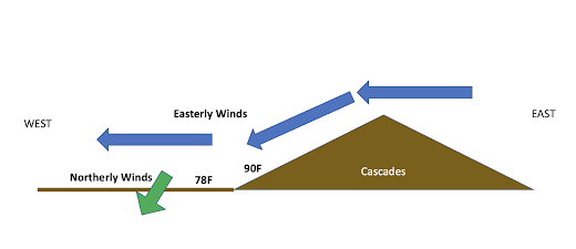
A schematic of the situation around Puget Sound is shown below (sorry, I am not much of an artist).  The easterly winds sinking on the Cascades warmed by compression, and thus very warm air was found over the lower western slopes of the barrier.   

But the descending air could not reach the western lowlands because of the cool, northerly flow near the surface there.   Cold air is denser than warm air and wins the battle to stay near the surface.

Very three-dimensional!
Now the temperatures today (Saturday) are again going to be a complex story...but a very different story.

The pressure pattern has changed greatly.   The low-pressure west of the Cascades has now shifted into eastern Washington.   Thus, the easterlies over the Cascades are history.  And with higher pressure offshore, cool marine air has started to move in.


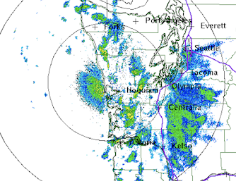
One sign of this onshore intrusion of marine air is the eastern movement of marine low clouds this morning (see below).


Now let me show you a fascinating figure:   the 24 h change in temperature ending 11 AM Saturday.

Mama Mia!   Hugely colder today along the coast where marine air is surging in.  Yesterday, the easterly, offshore-directed flow made the coast quite warm


Notice how it is warmer today from Seattle northward, where the cool northerly flow has weakened since the north-south pressure difference is less since the low pressure has moved inland.

East of the Cascades today is a bit warmer in general.

Tomorrow, the temperatures will crash in the west as a potent low-pressure system approaches the coast and an associated front makes landfall (see pressure and temperature forecast for mid-day Sunday below).


April 26, 2023

Warmer in Seattle Than Los Angeles or San Diego!

A short Northwest heatwave is ahead and it will come on with a vengeance on Friday.   

So get those tee shirts, shorts, sunglasses, and a cool drink ready.   It will be all the more jarring after an unusually cold spring.

Many of you will experience temperatures in the 80s....

Let me start with temperatures predicted on Friday around 5 PM on Friday by the UW WRF model.  The white areas are places where temperatures are predicted to rise to 80F or more.  White hot.


Temperatures will be cooler near Puget Sound and over Northwest Washington.  So if you like heat, move inland and south.  And cancel the trip to southern California--it will be warmer here! 

Saturday will be a transitional day, with cooler air starting to move inland on the coast.  But still getting to the mid-70s in the western Washington and Oregon interior.  Expect further warming over the Columbia Basin, where mid-80s will be commonplace (see the forecast for 5 PM Saturday below).


A state-of-the-science approach to forecast uses high-resolution ensembles of many forecast runs, each a little different.  Below are the temperatures predicted for SeaTac from the UW high-resolution ensemble system.  Most model simulations are going 80-85F on Friday, which would be a record for that date.  About the same in the Tri-Cities.  Add 3-5 degrees for Portland.


The origin of this warmth is an impressive upper-level ridge that will develop along the West Coast on Friday (see below).  Such ridges are associated with warm air aloft that gets even warmer as it rapidly sinks into the lower atmosphere (and thus warms by compression).


This high pressure aloft will cause the development of high pressure to our east that will result in easterly (from the east) flow over the region (see sea level pressure map, with low-level temperatures and wind).  Easterly flow will produce intense sinking on the western side of the Cascades and the Olympics that will result in substantial compressional warming.  


The temperatures should be warmest just west of the western slopes of the Cascades.    

The warm air results in lowered atmospheric pressure, called the thermal trough (apparent in the above surface map).  And easterly flow keeps the cool marine air away.

A classic pattern during our local heatwaves.

Enjoy.
___________________

The Northwest Weather Workshop agenda and information are online.   This meeting, which will take place on May 12-13th in Seattle, is the major weather meeting of the year in the Northwest.   We have a varied and interesting agenda.  The meeting is open to everyone and if you want to attend you must register (on the website).   

We will also have a banquet/talk at Ivar's Salmon House on Friday May, 12.  This is a fun meeting and will be hybrid (in person and on zoom).


April 25, 2023

Why is there often a strange, stationary radar echo along the Washington Coast?

Virtually every week someone asks me about a strange-looking weather radar feature that is often along the Washington coast.

UFOs?  Chinese balloons?   A stationary flock of birds?   Or could it be the ocean?   The answer is revealed below.


Below is an example on April 11th around 7 AM from the National Weather Service Langley Hill radar near Hoquiam Washington (the radar is shown above).  

You see the bluish area west of Hoquiam, just offshore on the central Washington coast?  That is the feature.  

The other features are areas of precipitation. 

They move.  The area off of Hoquim stays put.

The image above is for the lowest scanning angle that is typically used in U.S. weather radars, a half-degree (0.5 degree) above the horizontal.    However, the Langley Hill radar was giving permission to have a lower scan angle (roughly 0.2 degrees) due to the intercession of Senator Maria Cantwell.  

The image from that angle at the same time is shown below.

The feature has gotten stronger and larger!   A big hint.


Reflecting Off the Ocean

The Langley Hill radar is close enough to the coast that the radar beam at lower scan angles actually hit the ocean surface and reflects back to the radar receiver.  That produces the false echos.   If you climb up the tower (which I did during the dedication), one can actually see the Pacific (see the image below taken about 2/3rds up the tower).


One way to confirm the radar beam is looking at the ocean is to view the Doppler velocity field from the radar, which provides the speed of the target towards or away from the radar (see below).

The velocity of the "target" is essentially zero...so the object is stationary (which is generally not true for precipitation, which is blown around by the wind).


The intensity of the return off the ocean is influenced by the lower atmospheric temperature structure.   When there is a strong low-level inversion (temperature increasing with height), the radar beam tends to be bent towards the surface, leading to a strong signal.  This is what is known as a stable situation.

When temperatures decline rapidly with height, the beam is higher and there is less ocean return (less stable situation).


One thing you can be sure of:  that strange feature along the coast does not indicate coastal rain.  Or UFOs.


April 23, 2023

The Upcoming Northwest Heatwave and Snowmelt

 It is now certain that our region (and the entire western U.S.) will experience a welcome spring "heatwave", with substantial snowmelt causing a surge in river levels.

The origin of the big change is the development of a major upper-level ridge along the West Coast later this week.  To illustrate, here are the forecast 500-hPa heights (think of it as pressure around 18,000 ft) for 5 AM Friday.  The red colors indicated heights/pressures well above normal).   This major ridge is associated with warmer-than-normal air that will rapidly sink, warming by compression.

The latest National Weather Service predictions for Seattle indicate temperatures reaching the mid-70s on Friday and Saturday.  Add another ten degrees for the Columbia Basin.

The recent UW WRF model forecast suggests that some places in the west will get into the 80s in western Washington, with Portland rising into the mid-80s.

Folks are going to go wild after one of the coolest springs in Northwest history.

And then there are the rivers.....

Our snowpack is now above normal and this warmth will cause substantial melting of snow, particularly over the eastern slopes of the Cascades.   Currently, the snowpack is above normal over most of Washington State.    Way above normal in Oregon.

The surge in temperatures will result in substantial snowmelt, with some rivers rising rapidly.   Consider the situation on the Yakima River at Umtahum (see below).  The river will rise to near-record levels for the date by next weekend.  Snowmelt inspired spring flooding was a tradition in the Northwest before the dams went in.

Folks forget that the dams save many lives and much property by storing the water from springtime snowmelt, something the anti-dam crowd should learn more about.


April 21, 2023

One of the Coldest Aprils In Northwest History Will Soon Be History

April 2023 has been starkly cool over the Pacific Northwest. 

In fact, the second coolest on record in many locations.  The coolest in others.

Just look at the April temperatures at Seattle and Pasco compared to normal highs (purple lines) and lows (cyan lines) is enough to put a literal chill down your spine. Most days have had lows well below normal and only ONE day during April reached the normal high in Seattle.


A plot of the differences of temperature from normal for the past two weeks shows uber-cold maximum temperatures (blue color, 6-9F below typical) for much of Oregon and Washington.  


This is historic cold.  For example, at Olympia, the average maximum this month so far was the COLDEST on a record going back over 80 years!   In Seattle, it was the second coldest (2011 was the chilly winner).  

The bad news?  We will have to endure a few more days of these frigid conditions.

The good news?   In roughly a week, a strong ridge of high pressure will build over the region bringing MUCH warmer conditions...we are talking about highs around 70F in western Washington, and nearly 80F in the Columbia Basin.   Can you imagine this?

Below is the forecast upper level (500-hPa pressure) heights for 5 PM Thursday.  Mama mia, that is a nice ridge of high pressure!


Now consider the latest forecast from the National Weather Service National Blend of Models for SeaTac (below).  Low 70s on Friday and Saturday!  Spring!


And if you can't afford Palm Springs, take a drive to the Tri-Cities.  Pasco will be above 75F for at least a week and get very close to 80F.  Just perfect.  Not a bad time to check out the wineries in eastern Washington or enjoy the wildflowers over Rangeland country.


April 19, 2023

Increased Wildfire Danger over the Western U.S. from Wet and Cold Conditions

There is an enhanced potential for wildfires over the western U.S. this coming summer and early fall, but it is not due to warming and drying.

In fact, just the opposite.   A cool, wet winter has created an increased wildfire threat by producing a bountiful volume of flammable grasses. 

A threat that extends from eastern Washington into southern California.

Eastern Washington Near Thorp, WA, July 2022

When most people think of wildfires they usually refer to forest fires.  However, grass fires are just as important in the West, if not more so.  Furthermore, burning grass plays an important role in many forest fires. 

Many of the most damaging fires in the western U.S. have had a large grass contribution.  For example, the eastern Washington town of Malden, which was destroyed in September 2020, and the 2018 Camp Fire around Paradise, CA.

The distribution of seasonal grasses in the West is shown below (indicated by green colors).  There is a LOT of grasslands across eastern WA and OR, and over central and southern California.  And many of the forest areas have an understory that includes grasses and other seasonal vegetation.

The western U.S. has a Mediterranean climate, with winter precipitation and dry summers (yes, this includes Washington State).   Precipitation during the winter encourages seasonal grass growth and is followed by a summer warm/dry period, resulting in substantial flammable fuels by mid-summer.  All that is needed is an ignition source and strong winds, which result in rapid fire spread.

Research studies indicate that precipitation is most critical around November (which supports germination and early growth) and in March/April (which provides moisture as the strengthening sun encourages rapid plant growth).

Interestingly, western grasslands and rangeland have become much more flammable over time, as explosively flammable, non-native grasses such as cheatgrass have spread around the West.  This is NOT due to global warming.  And there are far more sources of ignition these days, including huge increases in electrical infrastructure and population at the urban/wildland interface.

To get an intuitive idea of how important grass fires are, here are maps of historical fire locations for central CA.  Lots of large fires away from the forested mountains.  Importantly, extensive grass near and within forested slopes can play a major role in initiating and spreading wildfires.


Numerous and extensive wildfires have also been found in grassland areas around eastern Washington State (see below).


The Situation This Year

The percent of normal precipitation during the present water year (from Oct 1 to now) is shown below. Most of California was wetter than normal as was southeast Oregon and the eastern slopes of the Cascades.  Surprised that the Cascade easterly slopes were moist?  Blame the easterly, offshore-directed flow that made the rest of the region dry!


Importantly, higher than normal precipitation has continued during the critical last month over California, Oregon, and yes, the eastern Cascade slopes.


All this moisture has encouraged luxuriant grassland growth around the West.   

Do you want to see some proof?

Below are two NASA MODIS satellite images for southern California: the first is for today and the second is from two years ago (2022), also on April 21.  

Look closely.  A LOT more green today.    When that stuff dries out....as it WILL dry out.... there is potential danger.


But let us get more quantitative about the wildfire threat.  

A wonderful USDA website called fuelcast.net uses precipitation and other data, manipulated using machine learning, to predict the dead fuel load (mainly dead grasses) later this summer (see below).   As noted by grassland/range expert, Dr. Matt Reeves, when the standing dead fuel load gets to about 800 pounds per acre, the wildfire threat is substantial.  

As evident below, substantial portions of eastern Washington, eastern Oregon and particularly California will reach that level.

The bottom line:  there is a substantial grass/rangeland wildfire threat this summer after the West dries out, as it always does.


There is a lot of talk in the media and others that wildfires in the West are mainly the result of heating and drying due to global warming.   The truth is perhaps a bit more nuanced and complicated.  Cool and wet winters and early spring can greatly increase wildfire threats.


___________________-

The Northwest Weather Workshop agenda and information are online.  If you want to attend you must register (on the website).   A few speaking slots are still open for those interested in presenting.


April 17, 2023

Where can you get the most skillful weather forecast? And a cool week ahead. All in my new podcast

 One of the most frequent questions I am asked is where can one get the most skillful weather forecast.

What are the best sources of weather information?  

I answer the question in my new podcast.

In the podcast I refer to a website, forecastadvisor.com, which provides updated comparisons of the forecast skill of various weather prediction websites (see sample below for Seattle's March forecasts).


The WeatherUnderground and WeatherChannel are on top.  The National Weather Service is less skillful.   

Do humans help produce better forecasts? What about TV weathercasters>  All will be revealed in the podcast.

The Forecast

Before I take on prediction skill, I talk about the cool forecast for the next week.  Seattle should be hitting around 60F every day.  As you can see below, Seattle will be much cooler than normal.


To listen to my podcast, use the link below or access it through your favorite podcast service.


Some major podcast servers:

 HTML tutorial HTML tutorial
Like the podcast? Support on Patreon 


___________________-

The Northwest Weather Workshop agenda and information are online.  If you want to attend you must register (on the website).   A few speaking slots are still open for those interested in presenting.


April 16, 2023

The Northwest Weather Workshop 2023


The Northwest Weather Workshop is the major local meeting for those interested in Northwest weather and is open to both professionals and interested amateurs.    

It will take place on May 12-13, 2023 at the NOAA Sand Point facility in northwest Seattle, and is sponsored by the University of Washington, the National Weather Service, and Seattle/Portland chapters of the American Meteorological Society.

The new agenda and sign-up information are all found on the meeting website: https://a.atmos.washington.edu/pnww/.  As described below, this meeting will be in-person with a virtual option.

The meeting is going to be a fascinating one (the current agenda is here).  

It starts on Friday afternoon (May 12) with a session on heavy precipitation and flooding, including a detailed look at atmospheric rivers and the historic 1962 "ARK" Storm.  Then we turn to a session on wildfire and smoke.

Friday evening there will be a meeting banquet at Ivar's Salmon House, with a wonderful buffet and a talk by Washington State (DNR) meteorologist Mathew Dehr on Washington wildfires.

Saturday morning (May 13) will start with a talk by American Meteorological Society National President, Brad Colman, and then turn to a session on Northwest climate and weather.  This session will include talks on extreme weather events, heat waves, and our changing climate.

Meeting Location in Seattle

Next, a session will examine the extreme February 2023 snowstorms that were both poorly forecast and brought Portland to its knees, followed by a talk by Shannon O'Donnell on the UW Dawgcast public forecast.

Lunch will then be served to attendees, followed by an afternoon session on Northwest weather modeling, social media weather sites, and much more.

Attending the meeting, costs, online versus in person

Everyone attending the meeting must register on the website.  You can attend either in person or online.

If you can attend in person, please do so.   Meeting people is half the fun.  There will be snacks at breaks and lunch on Saturday.  The cost for the in-person registration is $42., except for students ($21).  This covers the food.

The Friday banquet (in a very nice room at Ivar's and including a great buffet) will be $62 (including tax and tip).  As noted above, there will be a talk on wildfires. You can attend the banquet and watch the rest virtually if necessary.

If you want to attend virtually, there is no fee.  We will send you a Zoom link in the days before the meeting.  No food.   

After years of online meetings due to COVID, it will be nice to get the community together in person.  You must register and pay for the above options prior to the meeting (by May 9).  

See you there in person or online....cliff mass

PS:   I still have a few slots for talks.  Let me know right away if you have a presentation you would like to be considered.

The meeting will be in Building 9 (red arrow)


April 15, 2023

Does A Cold Spring Mean a Warmer than Normal Summer?

I have gotten a lot of questions and comments about the connection between a colder-than-normal spring and conditions during the summer.

Several folks are convinced that a cold spring means a warm summer, mainly based on what happened last year.  

So let's look at the data and find out!

Let's start by plotting spring (March-May) temperatures over Washington State using the NOAA Climate Division dataset for the past century (through 2022).  Warmer earlier in the period, then cooling in the 1950s-1970s and then warming back to the earlier levels during the past decades.  

I then identified the top ten coolest springs.

Next, I determined the top ten coolest springs and plotted their anomaly (different) from normal (the averages for 1991-2020) temperature for the summer (July through September)-- below.   

The result?  Summer surface air temperatures were substantially cooler than normal after cool springs.

So based on climatology, there is no reason to expect a warmer than normal summer...in fact, just the opposite.

But what about seasonal forecasting models, such as the one run by the European Center?    Below is its forecast for the surface air temperature anomaly from normal for July through August.     Very close to normal conditions are being predicted.


The Canadian seasonal model, which is quite good in general, is similar to the European Center (see below).  Near normal for our region.


In contrast, the American Model (CFSv2), which generally is not as skillful, has this summer warmer than normal by .5 to 2C.

The Bottom Line:

    At this point, there is no strong reason to expect a warmer-than-normal summer here in the Northwest.  Climatologically, cold springs do NOT tend to be followed by warmer than normal summers, if anything it is just the opposite.   The best season models show near-normal temperatures from July through September.

And I can't help but note that our seasonal forecasting skill, particularly for summers, is generally quite poor.  Meteorologists have come a LONG way with short-term weather prediction, but our seasonal prowess is something we need to be very humble about.  😇


El Nino is Rapidly Collapsing

 It's finally happening.    The pesky El Nino, with warmer than normal surface waters across the central and eastern tropic Pacific, is ...