May 30, 2009

Clouds on the coast and chaff


Last night a weak disturbance passed by us to the north. As a result the pressure trough over western Washington shifted eastward and the onshore pressure difference increased to near 2 millibars. The result...a weak influx of marine air that brought clouds to the coast, the Strait, and SW Washington. Thus, today will be a few degrees cooler than yesterday, although the clouds will burn back this morning.

A few weeks ago I talked about birds in the weather radar. Yesterday there was something else. Take a look at the weather radar from late yesterday afternoon...looks like showers near the Olympics and over parts of SW Washington. But it was clear. This is good example of chaff from military aircraft. Once in a while the miltary has some kind of exercise off the Oregon coast and release chaff..which blows inland during the next few hours. The radar really picks this up...making it appear that heavy or extensive showers are approaching the region. Why they release this chaff? I can't answer that.

For those of you that are interested, I will be doing 1.5hr show and call in on KCTS9 this Tuesday at 7 PM. They will offering my book and a DVD of the program as part of their pledge drive.

And check out the op-ed section of the Seattle Times tomorrow (Sunday)...there is a piece on the disastrous math decision of Seattle Public Schools. And Issaquah and some other local school district are considering the Discovering Math series. Hope they will think it though first.

May 28, 2009

Big Day for the Coastal Radar and our fine weather continues

It was an extraordinary day today. At a community forum in Seattle organized by Senator Maria Cantwell, the coastal radar issue was discussed in depth. The full cost of the radar is in the proposed budget...and if passed by Congress...the radar will happen. This is getting close to a sure thing. The National Weather Service was there in force, including their Director Jack Hayes and head of Science and Technology, Don Berchoff. The NWS is now an enthusiastic supporter of the acquistion and they have hired a team to do site surveys on the coast this week. By January or February a decison on siting should be done...AFTER community input and reaction. Talking about community, there was lots of radar supporters from the coast in attendance. This has been a community project from the beginning...and I think the NWS brass were impressed by the depth and variety of the radar advocates. Having Senator Cantwell on our side has been crucial, particularly since she chairs the subcommittee overseeing NOAA. And her staff have been terrific. Finally, the radar got a big play in the press..including the cover of the Seattle Times and all the major news programs.
There are a few battles left now. Many of us at the UW think the radar should be set up to scan as low as possible to get the most range...but the NWS has some rule of never going above .5 degrees above the horizon. We need to convince them. And we would like our radar to scan the skies in the most optimal way for our community, which includes both horizontal sweeps (call PPI in the business) AND up and down at at a constant azimuth (called RHI). The latter scans gives a detailed vertical cross section that really helps see the structure of weather systems and assists in determining precipitation over the mountains. But perhaps I am getting too technical here. But this is a revolution in the making.
The situation the next 4-5 days is nearly optimal for outdoor activities...temps in the 70s over the lowlands (near 80F tomorrow) with lots of sun and no lowland rain. No June gloom--at least for a while. Of course, there will be great temperature contrasts near shorelines, since the Sound and the Pacific are both around 50F

May 25, 2009

Sound Breeze!

During the warm season, the subtleties of local weather are to be savored, and none is more frequent than the Sound Breeze.

Official definition: the Sound Breeze is the northerly wind that develops during the midafternoon over the northern half of Puget Sound and which maintains itself until approximately 8-9PM. Over the central Sound the breeze can blow 15-20 knots, with less winds over land.

The sound breeze is important for everyone like to sail, fly kites, or bike home after work. Many an afternoon I have to bike right into it...slowing me down considerably. And it makes kite flying wonderful during the late afternoon at kites hills at Magnusson or Gas Work parks. And it is heaven for early evening sailors.

The Sound Breeze is really a big sea breeze circulation. Remember the sea breeze? Cool, ocean air moving towards the heated land during the day? In this case, we have the Strait of Juan de Fuca and Georgia Strait full of water and the Puget Sound basin mainly land. As the PS basin heats, the pressure falls and the northerly sea breezes pushes in.

Above are two maps of surface winds on May 23...one early in the day and the other at 4 PM. You can see a real strengthening of the northerly flow in time..the Sound Breeze in action.

May 23, 2009

No Weather


This is going to be an extraordinary weekend...dry, generally sunny, with temps in the lowlands around 70F. The satellite picture this morning showed some low clouds on the coast that pushed into the SW interior...but that will rapidly burn back (see image). Just to remind you of the rain, I have attached a plot of the average May rainfall (blue) and observed this month (red). Roughly double normal at Sea Tac.


A weak front will approach very late Monday..but that will not mess up the holiday weekend.

Watch for the Sound Breeze developing during the late afternoons...this is the northerly wind that blows southward into Puget Sound between 3 and 8 PM on warm summer afternoons. It is essentially a giant sea breeze between the interior of western WA (mostly land) and the waters of the Strait of Juan de Fuca and Georgia.

May 20, 2009

Lightning!


Sometimes the weather gets downright scintillating around here...and last night was a good example. An intense convergence zone formed north of Seattle, with heavy rain and even some small hail/graupel. My house was inundated, with 1.25 inches over the day. The strong convection in the convergence zone produced about a half-dozen lightning strikes with rumbling thunder. Thunderstorms here are generally wimpy in the lightning department...often with 1-2 strokes for the entire event.

My profession has sensors for lightning strikes. Ever listen to the AM radio during thunderstorms and hear intermittent static...that can be caused by lightning. With the proper receivers and electronics one can determine the lightning stroke location and intensity. Below you see lightning graphics from our regional system for the half hours starting at 7:30 and 8 PM Tuesday night. You can see the Seattle strokes.


One of the lightning bolts hit a power pole in Laurelhurst near the home of one of my colleagues. They lost power as the transformer blew up and pole ignited. Took the Seattle fire department two visits to get it out. With bears on the lose and lightning burning up power poles, this city is starting to get fun.

Just some reminders:

We need supporters of the coastal radar acquisition at the community meeting on Thursday, May 28 at 10:30 AM sponsored by Senator Maria Cantwell (NOAA Bldg 9 near Seattle Magnusson Park. The head of the National Weather Service will be there and we need him to know where we stand. You have to RSVP (coastalradar@cantwell.senate.gov).

I will be giving a talk on a consumer's guide to NW weather at Barnes and Noble, Univ. Village, at 7:30 PM on Friday.

May 18, 2009

Front and convergence zone


A fairly wet spring front is now moving through--the radar shows it clearly (see image). You every notice that the heavy rain never seems to spread over the Cascades? Why? blockage of the radar beam by the terrain. Most of the time you see the radar image from the lowest elevation angle (.5 degrees above the horizon). Many of us are hopeful that the new coastal radar will go lower (0 elevation angle)..which will more information near the surface close to the radar and give more range. The radar has a wavelength in the microwave part of the spectrum and the national weather service radars have about a megawatt of power. I can imagine what kind of cooking it could do.

The front will pass by tonight and the models indicate a strong Puget Sound convergence zone by daybreak (see image), with showers in the mountains. In fact, here is a 7 AM update (see radar picture)..the convergence zone formed as predicted...although shifted a bit north of predicted position. But we couldn't do this 20 years ago!

Additional showers will roll in tomorrow...but the remainder of the week and memorial day weekend looks good. But June gloom is threatening as the atmosphere over the Pacific become more stable as high pressure builds northward. A stable atmosphere allows the lower atmosphere to moisten and saturate...producing a huge stretch of low clouds that invades western Washington.

May 16, 2009

Finally...a nice weekend


It is interesting that we almost always have a mid-May break of nice weather...even during the worst years. And then we descend into the June low clouds before the major shift after July 4th. You can almost set your clock by it.

Today will be sunny and warm in much of the state...and the latest visible satellite image shows clouds limited to the NW portion of the Washington (see image). You will see a weak front offshore..that will be dissipating and moving on to the coast tomorrow afternoon...but its only effects on the interior will be some scattered clouds.

So today and tomorrow will get to around 70F in the Puget Sound lowlands...and eastern Washington will reach the mid to upper 80s tomorrow...head east for summer. Monday will be dry..and then rain returns on Tuesday. Will this warmth save my tomatoes? Time will tell.

..and remember to sign up for the radar forum on May 28th if you want to tell Senator Cantwell in person that you support the coastal weather radar (see last blog)....and note I will be talking at Barnes and Noble next Friday at 7:30 PM on a consumers guide to NW weather.

May 15, 2009

Community Forum on the Coastal Weather Radar

There will be a major local meeting on the acquisition of a coastal weather radar for Washington State on Thursday, May 28th at 10:30 AM, hosted by Senator Maria Cantwell, a key supporter of this acquisition. (see below for more info)

I encourage those of you who would like to learn more about the coastal radar and/or would like to express your support of this acquisition to attend. The head of the National Weather Service, Jack Hayes, will also be there. At this gathering they will release a report that analyzes the need for a radar on the Washington Coast. (I haven't seen this report yet!) Although we do have partial funding for the radar, this is still not in the bag, so community support is still critical. As noted below you must RSVP to attend. Thanks, cliff

Official Invitation:

U.S. Senator Maria Cantwell is hosting a community forum on the
Public Release of the Washington State Coastal Weather Study and Funding
As a result of the study funded through the efforts of Senator Cantwell, President Obama’s budget proposal includes $7 million to protect Washington State

Thursday – May 28th, 2009
10:30 am - 12:00 pm
NOAA – Western Regional Center
7600 Sand Point Way NE
BUILDING 9 - http://www.wrc.noaa.gov/
Seattle, Washington 98115-6349

If you would like to attend, please RSVP by email with your full name and organization you represent to coastalradar@cantwell.senate.gov

Parking is free and available, but please allow yourself time to proceed through the security gate and picture ID will be required.

May 13, 2009

Complaints


Well, even the weather-hardened crowd that follow this blog are complaining. Take a look at the last two weeks...generally much cooler than normal, with the last few days being way (10-15 F) below the norm (graphic...red and blue lines are average max and min temps). The mountains are getting substantial new snow...for example, heavy snow at Stampede Pass today at 4000 ft. Plenty of snow for skiing. The snowpack in the central Cascades is roughly 150% of normal. There won't be early hiking this year. And my tomato plants are dying.

Take a look at the same type of figure for the last six months...generally cooler than normal...but with a few warmer than usual periods. The December cold spell really stands out, and there are many more days our temps dropped below normal than climbed above normal.


The good news..the weekend looks warmer than normal. By the way, no one commented on the mother's day forecast...which did not work out well...things worsened far more rapidly than it looked on Friday.

PS: If any of you live in Bellingham and want to help stop the use of the absolutely worst elementary math text book (Terc Investigations)....please attend the Bellingham School Board meeting at 7:30 PM, Board Room, 1306 Dupont where this issue will be discussed. There was a nice editorial in the Seattle Times today excoriating the Seattle School Board for picking the fuzzy/reform math series Discovering Geometry and Algebra...which were rated unsound by the State Board of Education. It is source of continous amazement to me how poor a job these districts are doing in selecting educational material for our children.


May 12, 2009

Convergence zone has set up already

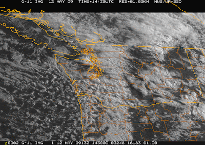
The convergence zone is already evident over the N. Sound (see radar image). And nice rainshadowing to the south. The showers are also evident over the western slopes of the Cascades. The visible satellite image shows the CZ band as well and offshore you see a field of instability clouds...heading our way that will reinforce the CZ. The best convergence zone events occur in such an environment.

May 11, 2009

More showers and a convergence zone.


As promised, the cool, showery pattern is back (see graphic). The same pattern we have been plagued with much of the last five months...northerly flow from Alaska aloft, trough over us. Why? Well, such patterns are more frequent in La Nina years, and we have been in a weak to moderate La Nina since December. So that may be part of it.
The winds really kicked up this afternoon as a trough moved through (graphic). The result was an increased south to north pressure drop in the Sound and an enhanced east-west pressure difference in the Strait. The result...strong southerlies in the Sound (reaching 20-30 mph) and similarly strong westerlies in the Strait. I was outside around 3:30 PM and even heard the crack of a branch failing, with the leaves blowing furiously...it was marvelous.

You can see the pick up of the winds at the UW during the afternoon in the graphic below. There is a very sudden cooling around 5 PM (00 UTC/GMT) as a passing cloud blocked the sun (you can see a drop in solar radiation in the lowest panel). Note that the relative humidity increases as temperature falls.


The next trough is now moving in, with showers moving in tonight and a good chance for a convergence zone tomorrow ( see image). There are some convective-looking showers out there that will be getting here by daybreak.


Wanted to note that I am working on a new lecture I will give at Barnes and Noble, University Village, Seattle, on May 22nd at 7:30 PM-- "A Consumer's Guide to NW Weather". I will describe how to be a good weather consumer...where to get the primo weather information, what web resources are good and bad, how to interpret radar and satellite pictures, and perhaps my views on local weather hype.

May 09, 2009

A nice weekend and Mother's Day


After four days of below-normal temperatures (see graph), we can look forward to a near or slightly warmer than normal weekend. The cold, wet weather has brought considerable new snow to the Cascades and the higher-elevation snowpack was enhanced (see photo at Crystal Mt.). Water will not be a problem for the western side of the State this year.
The computer forecast models indicate that a weak ridge aloft will build over the area this weekend (graphic), bring temperatures to near-normal (mid 60s) and no precipitation over the lowlands. Unfortunately, the cold, wet pattern that has haunted us this whole winter/spring redevelops on Monday and Tuesday (see graphic). My big decision...should I move my tomato plants outside with this this upcoming decline...probably not.


Heading to Port Townsend tomorrow(Sunday) to talk and sign books at 1 PM in the Rose Theater.

May 07, 2009

Major Advance for the Coastal Weather Radar

After the depressing events yesterday with Seattle's selection of an extremely poor high school math book series (see my previous post), it was delightful to get some extraordinary good news today: funding for the coastal radar has been added to the President's budget. Senator Maria Cantwell, a key supporter of the radar, broke the news today in a press release available on her web site (http://cantwell.senate.gov/news/record.cfm?id=312626). The implications of this inclusion are substantial...the National Weather Service is now supporting the radar and if the requested funding is approved by Congress (about 7 million dollars), the radar will become a reality.

There are details of course, such as determining the best locations, securing land, bringing in utilities, but these are all doable. Although we can't get this funded and acquired by the coming winter, there is no reason why the radar can't be in place for the winter of 2010-2011 if the National Weather Service works efficiently. And when this radar is installed, the citizens of this state will be far better protected from natural disasters with improved warmings and forecasts from the coastal waters to eastern Washington.

Want some more good news....the forecast looks quite good for the weekend...particularly on Sunday...Mother's Day. Sunny, dry, mid 60s. And everything is blooming.

Finally, on Sunday I will be in Port Townsend giving at talk at 1 PM at the Rose Theater on local weather...more information to the right. Will include a book signing (a local bookstore will have books). So stop in if you live on the Peninsula or wish to take the ferry from Whidbey. (Remember the Hood Canal Bridge is out for repair).

May 06, 2009

Tragedy in Seattle

Tonight the Seattle School Board finally voted on the acquisition of high school math textbooks, and the results were both disappointing and tragic. In a four to three vote they agreed to adopt the Discovering Math series...extremely weak discovery/fuzzy math textbooks. Found to be "unsound" by a panel of mathematicians hired by the State Board of Education, the books are obviously deficient to anyone who knows about mathematics. What really is upsetting is that that the Seattle School District has now picked poor math curricula three times...since they selected very weak math books at the elementary (Everyday Math) and middle schools levels (CPM math). The trifecta of ineffective math books.
The bottom line of all this is that it will be virtually impossible for students in the State's largest school district to get a decent education in math. This has not been a successful district...with their students' math performance lagging seriously... and they have now sealed the academic fates of students over the next decade or so (the last time they acquired new high school math textbooks was over a decade ago).

Since math is so important for a student's success in college and in the jobs of the future, this is a terrible setback for thousands of children and their parents. Tutoring companies will enjoy a bonanza as will private schools. Who could voluntarily send their children to such a district, knowing that they will be unprepared for the high-tech world of the future?

It was gratifying that three of the board members saw the problem and voted against Discovering Math (Michael DeBell, Harium Martin-Morris, and Mary Bass). Michael DeBell was particularly impressive and thoughtful. The board members supporting Discovering math claimed they were powerless to oppose the curriculum since the proper process was followed. It was painful to watch an obviously failing school district and the inability of the majority of the board to see beyond process to the desperate needs of the district's students.. The only hope on the horizon is that many neighboring districts are not making the same mistake and eventually their success will be such an embarrassment to Seattle that it will have to dump--at great expense---these turkey textbooks. A real tragedy.

It is also time for the community to work to replace several of the hapless Board members, who admittedly ignored a huge number of calls and emails on this issue. Of particular note was Cheryl Chow, whose embarrassingly long, rambling speech was both inappropriate and off-topic at the same time. We need better people than this to run the school district of our state's largest city.


May 04, 2009

The Big Storm


Well, I don't want you to forgot about the big Seattle math decision this week described in the previous blog, but I HAVE to discuss the big storm moving in later today.

It is really extraordinarily intense for this time of the year...reminds me of a strong November to January event. Ironically, we didn't get many strong windstorm/rainstorm events during midwinter due to the anomalous pattern that help in place this year, with a ridging over the eastern Pacific and a cold trough over the Northwest.

Take a look at the two attached satellite photos...one is a visible and the other is a water vapor image (in this picture the satellite is describing the amounts of water vapor in the middle to upper troposphere). The signature of a developing strong storm ins unmistakable, with broad areas of deep cloud. The water vapor image show an area of dry air behind the low center (green indicates moisture, black is dry). The strong storms usually have a tongue of dry, descending air right behind the low center.

The computer models indicate the storm will rapidly intensify today, but I think it will be coming in a bit closer than forecast (comparing the simulations against the satellite pictures). The simulations shows the low crossing northern Vancouver island with a low pressure of around 980 millibars (see attached graphics). This track does not bring the primo winds into Puget Sound...no more than around 20-30 mph from Seattle south very late tonight and tomorrow am. (see wind speed graphic) As the low moves north of us in the early morning hours, the winds in the Strait of Georgia will increase...so from Whidbey Is northward it will rock, with wind gusting to 40- 50 mph. The WA coast will get similar wind speeds. However, if track is closer in, as it appears from the satellite pictures at noon, the winds may be greater. I wish we had the coastal radar!!!!

And did I mention the rain...we will get plenty of that. The rain will move into western Washington this afternoon and moderate rain will occur tonight. (see graphic of 24-hr rainfall ending 5 AM tomorrow). Many places in Puget Sound will receive .25 to .75 inches, and the mountains --particularly the SW side of the Olympics will gain 2-4 inches. A nice addition to top off those reservoirs for the summer!
As I mention in my book, late season storms do happen...and some of them have caused tragic deaths, when group hit the mountains in May without checking on the forecast. By the way, for those on the Olympic Peninsula, I will be giving a public talk in Port Townsend on Sunday at 1 PM (see info at right).

May 03, 2009

Seattle's Big Math Decision

Many of you know that I feel strongly about math education and work closely with a group called wheresthemath.com. As a UW professor I have seen declined math abilities of incoming students, and some students can't follow their dreams of a meteorological career because of poor high school math backgrounds. And my own children have suffered from poor textbooks and math curricula.

The Seattle School District will be making a landmark decision on Wednesday for the selection of high school math texts. Their review panel (which didn't have a single mathematician or technical professional from the community) is favoring a terrible textbook series (Discovering Algebra and Geometry), which fosters the same "discovery" or "reform" approach that has done so much damage during the past several years. Their second choice (Prentice Hall Algebra and Geometry) is quite good. The Seattle School Board should reject the Discovering Math series if it is to insure Seattle students will get a decent math education. The School Board was split in the last meeting, and they need to hear from concerned citizens before the Wednesday gathering.

I have prepared a youtube video on the subject ( http://www.youtube.com/watch?v=n340ROI8uYc&feature=channel_page) and more information is available at www.wheresthemath.com. Please let them know how you feel (emails of school board members below). And those of you outside of Seattle will also be affected if the largest school district in the state goes the wrong way. Thanks for listening...cliff

School Board Directors:
Michael DeBell - michael.debell@seattleschools.org
Sherry Carr - sherry.carr@seattleschools.org
Harium Martin-Morris - harium.martin-morris@seattleschools.org
Peter Maier - peter.maier@seattleschools.org
Cheryl Chow - cheryl.chow@seattleschools.org
Steve Sundquist - steve.sundquist@seattleschools.org
Mary Bass - mary.bass@seattleschools.org

May 02, 2009

Winter (sort of ) in May


Looking at the weather maps, I had a sense of deja vu....is this January? In fact, the maps didn't look like January in January. This winter has generally been colder than normal with a major ridge of high pressure in the eastern Pacific and a cold trough over the Northwest. Rare has been the classic situation with strong, wet southwest flow heading into the west coast. But now it is here.
Yesterday was glorious buttoday some frontal bands are moving up from the SW. Take a look at the satellite and radar imagery...the band is clear...with relatively intense rain now falling over Puget Sound as it makes its way north.

The remainder of the week continues this trend...look at the upper level flow maps for the next several days (shown below). The lines are parallel to the winds and the closer they are the stronger the winds. Strong westerly and southwesterly flow that will bring a series of weather systems and rain into the area. In fact, a pretty strong low is forecast to cross northern Vancouver Island late Monday (see map).

So if we didn't get classic winter in December or January...at least we will get it in May. Something to be thankful for. I guess.

PS: Want to see the cooling power of evaporation--take a look at this plot of temperature, humidity and other parameters at UW today. As the rain started in earnest around 6 PM (o100 GMT/UTC), the RH jumped up (due to evaporation of falling rain) and the temperatures plummeted. As the air saturated (RH near 100%), the cooling ceased.

PSS: Due to the warm weather my vegetable seeds have germinated...soil temps are now in the low fifties. The cloudy weather will prevent any real cold...so delicate plants should be ok.

A Near Perfect Forecast of Yesterday's Event. The Next Windstorm Comes into View

 The next time someone makes a weatherperson joke, remember the nearly perfect forecast for yesterday's wind event over Washington. No l...