August 31, 2023

A Fascinating Precipitation Line on Tuesday

 On Tuesday about a half-dozen folks sent me messages regarding an intense radar band over western Puget Sound and the San Juans.  Others reported continuous lightning and hours of downpours.

This is after a relatively warm, dry summer.   So I decided to take a look at this unusual feature.

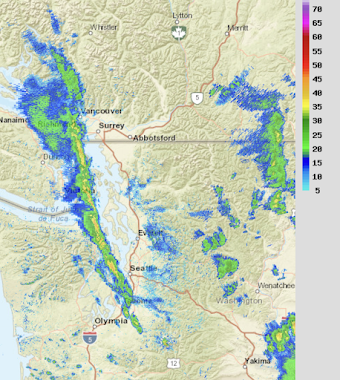
The radar signature was impressive, with a long intense line stretching from around Tacoma to the San Juans for hours (see radar image just after noon on Tuesday).  And this band held in for hours.


The precipitation band was highly convective, with lots of thunderstorm activity.  Thus, the lighting map for all of Tuesday showed an impressive line of lightning activity that passed over those poor folks in the San Juans.    Lots of lightning over eastern Washington as well, but over a broad area.


How much rainfall fell that day?

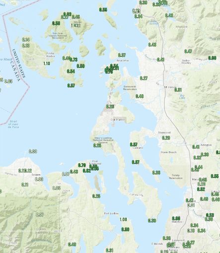
The Tuesday totals were impressive, reaching 1.43 inches over eastern Orcas Island and 1.10 over Friday Harbor.  As a result, Friday Harbor ended up with one of its wettest Augusts over the past few decades.


Now the depressing part for me.  High-resolution models failed to simulate this convective line.  Not the UW WRF modeling system nor the NOAA National Weather Service HRRR model.

So now the detective work begins.  Failure is always more educational than success.

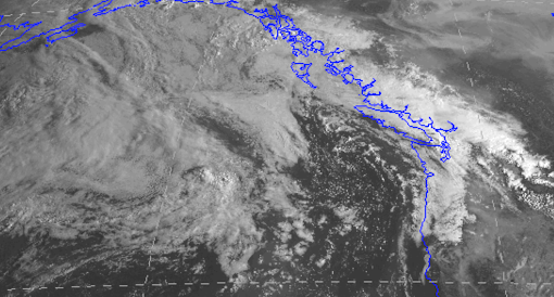
The thunderstorms in the line were relatively small, compared to the big ones in Eastern Washington (see satellite image around the same time as the radar picture)


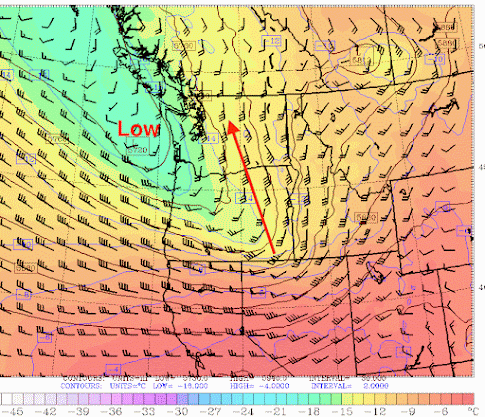
The thunderstorms were aligned with the airflow aloft....which was from the south-southeast from around 13,000 ft to 20,000 ft (see map of winds and pressures/heights at 500hPa...around 18,000 ft).  The red arrow shows the direction of the flow aloft.  A low/trough was approaching, which was important.  Such a trough provides lift or upward motion and it is associated with cold air aloft (green colors).

Cold air moving in aloft promotes instability....the mixing of the atmosphere in the vertical... because it enhances the decrease of temperature with heights.  Large declines in temperature with height causes the atmosphere to become unstable, which leads to cumulus clouds and thunderstorms.

No wonder there were a lot of thunderstorms over the region...the air was unstable and that instability is promoted by the upward motion associated with an approaching upper level trough.

But why is the narrow line of thunderstorms oriented roughly north-south?  Could this represent a convergence zone downstream of Mount Rainier? Both the Olympic Mountains and Vancouver Island have convergence zones in their lee that produce convective shower lines when the winds are from the northwest ( see example below)


But this hypothesis will not work in this case because the low-level winds (below 12000 ft, where most of the blocking effects of Rainer are produced), were not from the south-southeast.

Then I took a look at the high-resolution WRF simulation from Tuesday to see what it was trying to do.  Although the model did not have the line during the afternoon, it had something similar around 5 AM in the morning (see below).


Anyway, I will examine the origin of this line more comprehensively over the next few days and let you know what I find.


August 29, 2023

Meteorological Autumn Starts Today

The meteorology of a region does not necessarily follow the calendar, and that is certainly true for the Northwest.

Calendar autumn--starting at the fall or autumnal equinox-- begins on September 23.

But meteorological autumn in the Northwest generally starts the last week of August, with increasing precipitation and declining temperatures.

And this year will be no exception.

The satellite image this morning shows clouds and showers over the Northwest and developing weather systems offshore...with our name on it!


Showers and thunderstorms have moved through the region during the past several hours, as shown by 6:30 AM weather radar composite below.  Particularly heavy showers over northeast Washington.


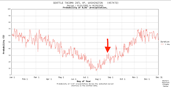
To gain some insight into our regional climatology, check out this graph of the climatological probability of receiving at least 0.01 inch of precipitation in a day at SeaTac Airport (with an arrow indicating today).  On average there is a huge increase in precipitation probability between the last days of July (around 8%) to today (about 30%)


Major atmospheric circulation changes have already started, with an increasing north-south temperature difference and the acceleration of the jet stream.

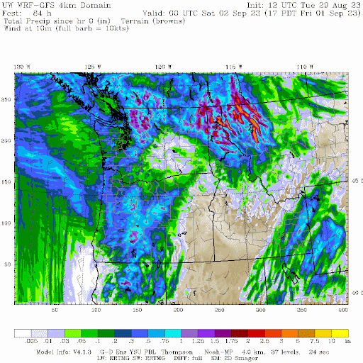
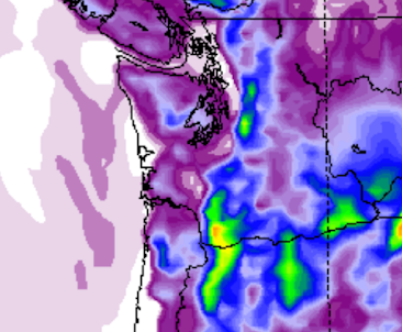
The latest high-resolution prediction of precipitation accumulation over our region through Friday at 5 PM (starting 5 AM this morning) is shown below.  Much of the region, except the lower Columbia Basin, will get a good wetting, with particularly heavy amounts in the north Cascades and the Oregon Cascades, as well as the northern Rockies.

Well placed to knock down some of the current wildfires.


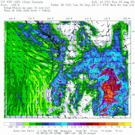
The prediction of precipitation total for the subsequent 72 h shows continued precipitation west of the Cascade crest.


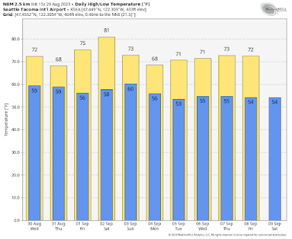
Temperatures will be far cooler than we have dealt with during the past months, as illustrated by the extended forecasts at Seattle and Pasco (from the National Weather Service National Blend of Models).  In Seattle, highs only around 70F Wednesday and Thursday, a brief warm spell from Friday through Sunday (reaching 81F), and back to around 70F the following week.


Pasco in the Tri-Cities only warms to the mid-80s.


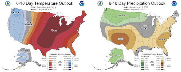
The extended range 6-10 day forecast from the NOAA Climate Prediction Center shows cooler than normal and wetter than normal conditions expected.


This change in weather takes place at a critical time since we are now in the period when western Washington and Oregon are traditionally vulnerable to westside fires driven by strong easterly winds.

But not this year.

Finally, there is a definitive indication of when a major cool-down will is occurring, one supported by the experts in the City of Seattle: 


_________________________________________

I am teaching Atmospheric Science 101 this fall in hybrid mode.

You can attend in person or online.

I should note that Washington State residents over 60 can take it for a very small charge (like $25)  through the ACCESS program.

And I would certainly welcome any UW undergraduate or graduate students.


August 27, 2023

The Essential Ingredients of the Most Destructive Wildfires: Wind and Grass

When many people think of wildfires, they often first visualize a forest fire.

And when the media and politicians talk of wildfires, they usually hone in on drought and climate change as the cause.

But if one is interested in the wildfires that kill and injure the most people, or wildfires that do the most economic damage, forests and drought are not the key factors.

In reality, it is grass and wind, which can produce rapidly expanding grass/range fires that have resulted in billions of dollars of loss and the deaths of many hundreds of individuals.

As described below, grass/range fires are the main threat to humanity.  And there is much we can do to reduce the terrible impacts of these events using the best science, technology, and land management. 


Note: The term rangeland includes tallgrass prairies, steppes (shortgrass prairies), desert shrublands, woodlands of small shrubs, savannas, chaparrals, and tundra landscapes.   Such vegetation often desiccates during the warm season (or under temporarily dry conditions).

Some Examples of Major Grass/Rangeland and Wind Fires
  • The 2023 Maui wildfire in which 60-90 mph winds descended the West Maui mountains and resulted in electrical fires that spread through fields of flammable grasses into Lahaina.  Over 100 lost their lives, with billions of dollars of direct and indirect loss.
  • The 2018 Camp Fire that destroyed the town of Paradise, California, resulted in 85 deaths and over 16 billion dollars of damage.  Strong winds descending the Sierra Nevada caused electrical fires that spread on grass/range vegetation (and some trees) rapidly toward the town, with little warning.
  • The 2022 Marshall Fire, when strong winds descended the Colorado Front Range, pushing a grassfire into Superior Colorado, killing two and destroying over 1000 homes.  Damage is estimated to exceed two billion dollars.
  • The September 2020 Malden (WA) Fire, in which powerful northerly winds resulted in sparks from the broken powerline that ignited range vegetation that surged into Malden, destroying most of the town.
  • The October 1991 Tunnel Fire, in which strong easterly flow resulted in a grass/range fire that destroyed nearly 3000 homes and killed 25 near Oakland, CA. 3-5 billion dollars in damage.
The Marshall Fire Burned Through Grass into Superior, CO. Picture courtesy of Tristantech.

The largest fires this spring/summer in Washington State were grass/range fires (see map for eastern WA).


I could provide you with dozens of other examples, but the message is clear:  the overwhelming majority of wildfire deaths and the bulk of the economic loss from wildfires are associated with grass/range vegetation and strong winds.

Grass and Range Fires

Grass and range fires occur in light fuels: grasses, small bushes, and the like.   They often go through a distinct seasonal cycle:  greening up during the cool/wetter winter and then drying out, with the foilage above the surface dying (see picture above).

Grasses and small vegetation (less than 0.25 inches) are 1-hr fuels, which means they can dry out within roughly an hour.  Small bushes are 10-hr fuels.

The fact that such vegetation can dry out very quickly under the right conditions (no precipitation, lower humidity, strong winds), means the previous weather/climate conditions are of minimal importance. 

Even if it rained the day before, they can rapidly dry out to support fire.   Particularly, with strong, dry winds, these light fuels will be ready to burn quickly.   So prior "drought" in the weeks or months before is pretty much immaterial.

What can increase the risk of range and grass fires is above-normal precipitation during the previous spring and winter, which results in more bountiful grass growth.  Thus, drought the previous winter would REDUCE wildfire threat,  a subtlety absent from most media stories.

Rangeland in Hawaii. Picture courtesy of Aaron Yoshino

Wind and Grass/Rangeland

Wind plays a huge role in grass/rangeland fires.  Once the fires are started, strong winds provide huge amounts of oxygen for the fire, and rapidly push the fire forward by moving hot embers and superheated air ahead of the flame front.

Wind can also help dry the light fuels, by greatly enhancing evaporation.   Dry winds are particularly good at very quickly drying grass fuels.     

This is why strong downslope winds are the absolute worst situation.   As the air descends and accelerates down the slope, it is warmed by compression, and the relative humidity plummets.

Thus, many of the great wildfire disasters (Maui, Marshall fire in Colorado, Camp Fire west of the Sierra Nevada) are associated with downslope windstorms.


It is important to note that there is no evidence that winds are increasing or downslope windstorms are becoming more frequeny due to climate change.  In fact, the opposite is suggested on the West Coast, where substantial research suggests that warm/dry easterly flow down the western slopes of the Sierra Nevada and Cascades will WEAKEN under global warming.

The Grassland/Range Wildfire Situation is Getting Worse--And it is NOT Because of Climate Change

Grass/range wildfires driven by wind have always been serious threats, but deaths and damage from them are increasing. Climate change is not the reason.

First, much of the western U.S. and Hawaii have been invaded by non-native, invasive, and highly flammable grasses.  One of the worst is cheatgrass, which is now found extensively around the nation (see map).


In Hawaii, invasive, flammable grasses have invaded agricultural lands that have been abandoned during the past few decades, resulting in huge flammable areas next to densely populated areas (see map below)


But the increase of vast areas of flammable vegetation is only part of the problem.

Increased population has resulted in far more powerlines, which are providing a potent ignition source of fire when winds are strong.
And increasing population near and in grasslands has resulted in hugely increased vulnerability to grass/range fires.

Finally, increasing grassland/range fires also results in increased forest fires, because grassland and forest are often adjacent and intermixed, and grasses/shrubs extend into forest areas.  Grass/range fires can move into forest areas, where the fire can ascend into canopies through a variety of ladder fuels.


Dealing with the Threat of Grass/Range Wildfires

There is much we can do to lessen the threat of grass/range wildfires.   We can save many lives and greatly lessen the damage from such fires.  

But to do so requires that society deals with the real origins of the problem and attack the problem in a rational, science-based way.  In this final section, I will describe some approaches that can help.

Use Weather Prediction and Fuels Information Better

During the past decade, the ability of high-resolution weather forecast models to predict the conditions associated with wind-driven grass fires has gotten stunningly good, specific in both time and space.  But this valuable information is often not effectively applied

For example, numerical prediction models clearly forecast the extreme winds and low relative humidity associated with the Maui fire (see my previous blog on this).  But little of the extreme threat near Lahaina was communicated.

In addition, satellite-based observations coupled with machine learning now provide real-time maps of where range-grass fuels are available in dangerous quantities (see the wonderful USDA Fuelcast site graphic below)


By putting the two data sources together (predicted winds and available dry fuel), we can provide very timely warning of wildfire threats.

Let me be very concrete here.   Wildfire Prediction Centers should be established for Hawaii, Alaska, and the lower 48 states to provide such guidance, as well as to interact with local authorities and power companies.  

The National Weather Service and other agencies must become much more aggressive in providing specific and timely warnings of this threat.

Deal with the Electrical Infrastructure Problem Through De-Energizing and Hardening Powerlines

Let's be frank.  Many of the most deadly and destructive grass/range fires have been caused by failing powerlines, which cause sparking that easily ignites the "kindling" of dry grass/range vegetation. 

In many areas, power infrastructure needs extensive and expensive remediation. 

Until we can harden the current power infrastructure, much more aggressive de-energization of powerlines is required.   Fortunately, high-resolution weather prediction and knowledge of the state of the surface fuels can allow such power shut-offs to be limited in time and space.


Creating Fire Breaks around Range/Grassland Areas Near Populated Regions, Reducing Grass Load.

Firebreaks can be created near population centers, and grazing animals and mechanical cutting can be used to reduce fuel density, among other steps.

Improved Construction in Dangerous Areas

As clearly shown by the Maui, Marshal, and Camp Fires, homes and buildings take over as a fuel source as grass/range wildfires reach urban areas.  Non-flammable roofs, screens to prevent invasion of firebrands/embers, removing vegetation near buildings, and other steps can make a huge difference.  The lone house to survive in Maui was a stark illustration of the ability to reduce risk.


The Bottom Line:   Grass/range fires are the major cause of wildfire deaths and economic loss in the U.S.   Such fires generally result from seasonally dry fuels and strong winds. Since the dry fuels can be monitored and the winds skillfully predicted, the potential for large and rapidly expanding grass/range wildfires can be forecast in advance with some skill.   Climate change has little to do with such grass/range fires.  Many steps can be taken to reduce the grass/range wildfire risk.
August 24, 2023

Regional Wildfires Were Greatly Reduced by Recent Rain

 For those of you concerned about wildfires and wildfire smoke, I have some very good news:  recent rain has greatly knocked back regional wildfires, particularly in British Columbia and Idaho.

Furthermore, substantial rain is predicted over British Columbia next week, which should help maintain the reduction.

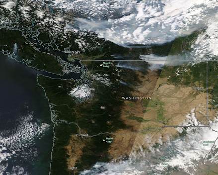
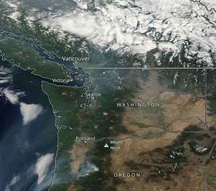
To illustrate the changes, below are NASA MODIS satellite images taken around noon today and on August 18th.  On August 18, major fires were pushing lots of smoke out over southern BC and the north Cascades.   MUCH less smoke today, although a thin veil of regional smoke remains.

August 18

August 24

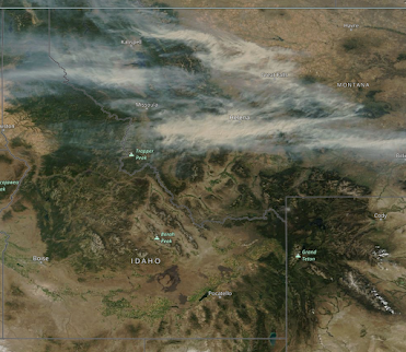
Idaho and western Montana imagery are shown below. On August 18th, there were major smokers over the Rockies.


But only some residual smoke today!  Much better.


The main cause of this reduction was the substantial rain during the past week.  

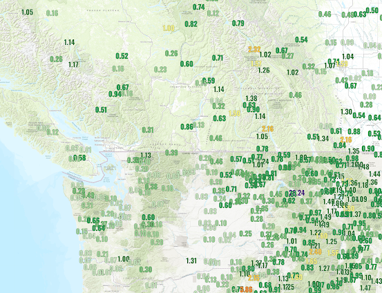
Below are the totals over the past five days.  1-2.5 inches over portions of southwest BC and Western Alberta.   And similar totals over Idaho and western Montana.   Serious precipitation.


You can thank the remnants of Hurricane Hilary for a lot of this wet bounty.

And more is coming.

For the next few days it will be generally dry and warm, but early next week the spigot will be turned on again as a strong trough of of low pressure moves through. Take a look at the predicted totals for the 48 hr ending 5 AM next Thursday (below).

Wow...southern BC will get a lot more rain and that will further extinguish or reduce wildfires.   The main source of our recent smoke will be greatly lessened.

The northern Rockies and Cascades will get precipitation as well


At this point, I am increasingly optimistic that the current lower-than normal burned acreage situation in Washington State will continue into early September.  The amount of forest fires has been particularly low over Washington State this summer.

Keep in mind that we only have about a month left of the Northwest wildfire season.


August 22, 2023

Smoke Moves Out, Rain Moves in, and the a Westside Wildfire Threat

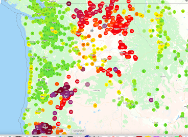
With the onset of moderate onshore flow, the smoke has been pushed out of western Oregon and Washington, with relief now spreading over eastern Washington (greens indicate good air quality, and yellow is acceptable). 

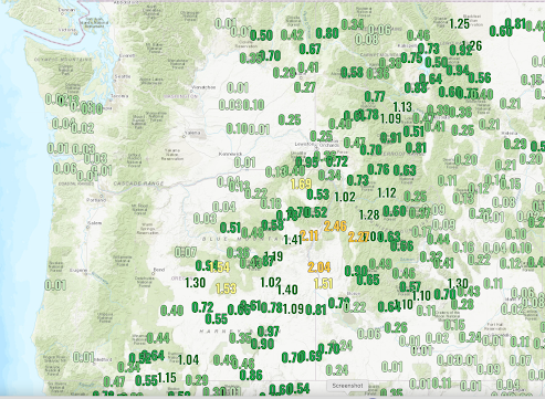
Moisture from ex-Hurricane Hillary has wet down the interior of the Northwest, with precipitation over the past 36 hr really soaking northeast Oregon and Idaho.   Plenty over the eastern side of Washington State.   Excellent news on many fronts, including the suppression of wildfires.

36-h rainfall ending 1 PM Tuesday

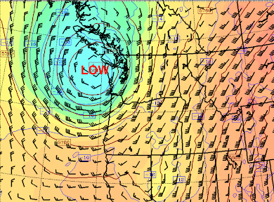
Currently, there is a potent low-pressure area along the Washington Coast (see upper-level map around noon today--Tuesday), which is keeping us cool and bringing some scattered showers to the coast.


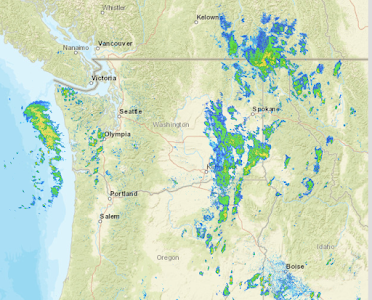
In fact, the radar image at 2 PM shows a moderate rain band approaching the Washington coast and the remnants of Hilary over eastern Washington (see below).   Almost feels like autumn today.


But something has me worried.

Our region will warm up temporarily, Thursday through Sunday, probably into the mid-80s around Puget Sound.

But that is not what I am concerned about....but rather the potential for localized easterly winds over the western Cascades slopes during late Thursday and Friday.  Easterly winds accompanied by low relative humidity could encourage wildfires.

It is important to note that mid-August to mid-September is the favored season for westside wildfires.

On Thursday, high pressure will build over Alberta and start to move southward into Montana (see map of sea level pressure, winds, and low-level temperatures at 11 PM Thursday).

That high pressure will force easterly (from the east) winds over the Cascades which will also result in warming and drying.


The geographical focus of the strong easterly winds will be the western side of the Columbia Gorge (see predicted wind gusts around 11 PM Thursday).  Some easterly gusts to around 30 knots


And the Hot-Dry-Wind index, which considers dryness and wind, shows concerning values east of Portland (see below, yellow and red colors are the worst) late Thursday and early Friday)


Let me be honest.... I have seen a lot worse conditions than this (e.g., September 2020).... but folks need to be careful not to start any fires on Thursday or Friday on the western side of the Cascades, particularly near the foothills of the Cascades near Portland.


August 20, 2023

Smoke Increased Rapidly this Afternoon But Soon Will Be History

 Call it a "smoke storm" perhaps, but the well-forecast onslaught of mainly British Columbia wildfire smoke came in with a vengeance.

But before I discuss the details, let me note that our new-found ability to predict the generation and movement of wildfire smoke has become extraordinarily good.   Good enough to help warn vulnerable populations days in advance.

And our ability to predict the winds that can initiate and expand wildfires has also developed rapidly.  Lahaina and similar wildfire disasters don't have to happen.

The visible satellite imagery this afternoon shows both the smoke over portions of the Northwest as well as the plume of moisture associated with Tropical Storm Hilary (see below).  And if you look closely on the upper level part of the image you can see clear skies associated with clean ocean air.  

The smoke-free air will be here tomorrow morning.


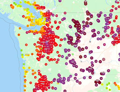
The PurpleAir air quality map around 3 PM shows poor air quality (purple colors) over eastern Washington and seriously degraded air quality (reds) over much of western Washington and the Willamette Valley.
 
Better conditions over NW Washington and along the coast. 


What was so startling about this situation was the rapid deterioration around noon over the western interior.

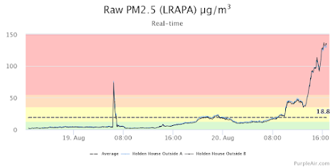
Smoke initially came in aloft, but it mixed rapidly down to the surface as the temperatures rose this morning.  To illustrate, take a look at the small particulate concentrations today near Boeing Field in Seattle (below).  

Wow... at 8 AM, the PM2.5 (small particle) concentrations were around 15 micrograms per cubic meter but rose to about 120 by mid-afternoon.   

I don't go running when it is above 75.

Why did it go up so quickly?  

Because the atmosphere and the movement of smoke particles are highly three-dimensional.

Let me show you.

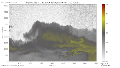
Puget Sound Clean Air Agency has acquired devices called ceilometers that can measure the distribution of smoke and particles above a location (it uses upward-directed laser beams to sample the smoke distribution above).

Observations from the ceilometer at Marysville, Washington (below) showed smoke coming in aloft overnight, with the yellow colors being the highest concentrations.   

But look at what happened after noon (time increase to the right).  YIKES.  The yellow colors extended all the way to the surface...and thus our air quality degraded.


Why did this happen?   It had to do with vertical mixing.   

This morning we had cold, dense air near the surface, which resisted mixing with the warmer smoky air aloft.  But the heating by the sun this morning warmed the surface, resulting in vertical mixing that deepened over time.  Warming air near the surface causes low-level air to become more buoyant, with a tendency to rise.  Air from above sinks to take its place.

This process is called convective mixing and helps bring the smoke aloft down to the surface.

The Future

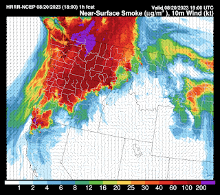
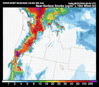
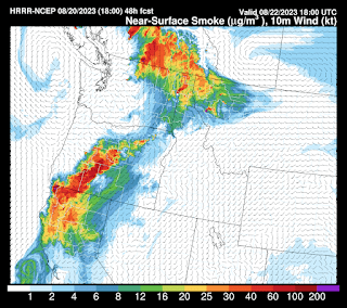
Our best smoke model, the NOAA HRRR Smoke, paints an encouraging trend for the next day.

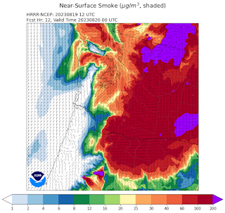
At noon today, there was lots of smoke in the region (see near-surface smoke prediction at that time).


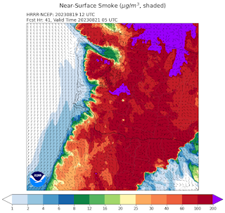
By 11 PM tonight (Sunday), onshore flow is eroding smoke along the coast and Hilary rain and wind are lessening smoke over southeastern Oregon. 


By 5 PM tomorrow, much of western Washington and Oregon are smoke-free and big improvements have occurred over eastern Washington.


And by Tuesday morning, western Washington, southwestern BC and coastal Oregon are completely out of the murk.

Most of this smoke has come from British Columbia.  Warm/dry conditions contributed but even more important has been the poor maintenance of BC forests and the completely inadequate resources provided by our northern neighbor for thinning, prescribed burns, and sufficient fire-fighting resources.

A topic for another blog.


August 19, 2023

Smoke and Tropical Storm Hilary

 There is an interesting mix of weather this weekend.

On one hand Hurricane Hilary, soon to be a tropical storm, is off the southern tip of Baja and moving quickly northward (see satellite image his AM).   A current of enhanced amounts of water vapor leads the storm resulting in substantial precipitation even now over the Southwest U.S.


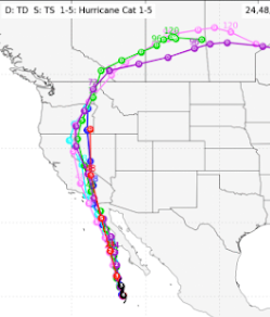
The storm path is now clear, with the remnant of Hilary passing over eastern Oregon and Washington! (see below).  An ex-tropical storm over Washington State...

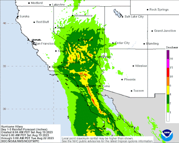
Although Hilary will now rapidly weaken, it will produce very heavy rain over the U.S. Southwest and lighter rain over eastern Oregon and Washington.    The predicted precipitation through Tuesday by the NOAA Weather Prediction Center is shown below.


Some locations could get over 6 inches, with the potential for serious flooding.  This event will suppress wildfires over central and southern CA for a long time, ensuring that this will be one of the most benign wildfire seasons in years for the region.

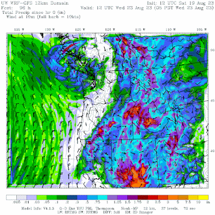
Turning to the Northwest, the predicted rainfall totals through 5 AM Wednesday are shown below.  The inland moisture is mainly the result of Hilary.  Very substantial amounts in eastern Oregon and portions of eastern Washington.   A weak trough of low pressure will bring some light rain to northwest Washington State.


The Smoke

For much of the summer, we have escaped the smoke from the western Canadian fires, but for 48 hr we will experience a taste of it.

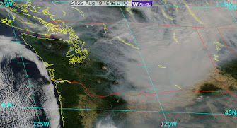
The visible satellite image this morning shows lots of smoke over eastern Washington, which is now pushing westward across the Cascades.


Why this change?  

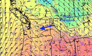
Because the protective, and typical, onshore flow of air off the clean-air Pacific has been temporarily replaced by offshore (easterly) flow as a transient area of high pressure has moved to our east (see below).  Higher pressure inland and lower pressure near the coast result in easterly (from the east) wind. This configuration is very temporary since low pressure from Hilary will soon be moving northward into Idaho.


The mainly Canadian smoke has caused air quality to decline substantially over eastern Washington to very poor levels (see PurpleAir map around 10 AM Saturday), while western Washington and Oregon still enjoy decent air quality.


But expect air quality degradation west of the Cascades crest as suggested by the latest predictions of the NOAA HRRR smoke system (predicted surface small particle concentrations are shown below)

This morning at 9 AM, most of the surface smoke was east of the Cascade crest.

By 5 PM Saturday, most of western Washington will be experiencing smoke, but nothing like eastern WA.

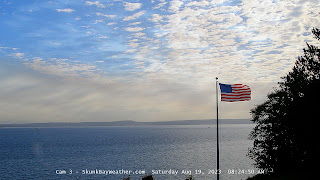
The arrival of Canadian smoke aloft this morning is suggested by this morning's weather cam at the Skunk Bay Weather observation location on the northern Kitsap Peninsula.


5 AM Sunday, modest smoke covers the West.

But by 10 PM Sunday, clean air is starting to push inland from the coast.  Monday will be a relief from the smoke as marine air surges eastward, atttraced by the low pressure from the decaying tropical storm.

If you are in eastern Washington, using a good mask or staying in air-conditioned facilities would be a good idea until Hilary does its magic on Monday.

A Near Perfect Forecast of Yesterday's Event. The Next Windstorm Comes into View

 The next time someone makes a weatherperson joke, remember the nearly perfect forecast for yesterday's wind event over Washington. No l...