April 29, 2022

How Understanding Temperature Can Save Your Life. Plus a Mixed Weekend Forecast

 My podcast discusses surface air temperature, how it varies, and how a little knowledge about it might save your life while driving.  Check it out either through the links below or through your favorite podcast service.

And there there is this weekend, which is also covered in the podcast.  Today (Friday) has been quite pleasant but a fairly strong front is rapidly approaching rapidly.

2 PM Friday

The front will move through Saturday morning bringing moderate rain with trailing showers.  By Sunday morning the entire region will be wetted down, with Oregon getting the brunt of the precipitation (see below)

Sunday should be very nice as high pressure builds aloft, with temperatures surging into the 60s in western Washington.  Then on Monday, a potent system will come in from the Northwest, dumping another major shot of precipitation into Oregon (see below).   This is all very good news, since Oregon has been considerably drier than Washington this winter.


To listen to my podcast, use the link below or access it through your favorite podcast service.


Some major podcast servers:

 HTML tutorial HTML tutorial
Like the podcast? Support on Patreon 


April 27, 2022

A Mysterious Cloud Circle Appears Near Victoria and the San Juans

A mysterious cloud circle appeared over the skies near Victoria and San Juan Island last evening around 6:45 PM (see a photo taken by Robert Beck, MD).

I received several emails with pictures, and the Twittersphere is alive with more pictures and speculations.

People are concerned, worried, amazed, and curious.   UFO?  Chemtrails?  Strange natural cloud?  The atmospheric version of crop circles?

So as a public service, let us try to solve this mystery!


Let's start by looking at a high-resolution visible satellite image at the time! (see below)

Look closely and you will see some thin high clouds just north of the San Juans...and also near Port Townsend.  These are thin cirrostratus clouds, located between 25,000 and 30,000 ft.


Important clues.  And look closely to the northwest of Sequim....there are faint lines.  These are contrails produced by aircraft.

Contrails result from the moisture and particles ejected from jet aircraft engines, with the moisture (water vapor) subsequently condensing in the cool, upper atmosphere.   Contrails are particularly evident when the atmosphere aloft is near saturation...something indicated by the cirrostratus clouds.

Normally contrails are straight lines. 

But let's go one step further and look at the observations of the balloon-launched weather observations at Quillayute on the Washington coast at about the same time (see below).  The Y-axis is height in pressure (hPa), the X-axis is temperature, the red line indicates the observed temperature and the blue-dashed line is dew point.  When the temperature and dew point are close together the air is near or at saturation (clouds are possible).   

Note there is an area in the upper troposphere (400 to 300 hPa pressure, about  25,000 ft above the surface) that is near saturation (temperature and dew point are nearly the same).   That is the altitude where cirrostratus clouds and contrails would occur.   Nice confirmation.


 Is it plausible that an aircraft did a tight circle around 25,000 ft above the surface?

Or a trick by a meteorological Professor Moriarity?

Let's look more closely at a photo taken by Beth Shirk (see below). 

Eureka!  You can see a contrail enter the circle and one exiting (both on the left sides)


This is clearly an aircraft contrail.    Possibly a military jet.  Probably too tight a circle for a commercial plane.  Not a UFO.  Certainly not a chemtrail (which don't exist by the way).

Let me end with a longer-distance view by John Polstra.   An unusual sight and a bit disturbing.
________________________________________________ 

Reminder:    The Northwest Weather Workshop On May  7

If you are interested, check out the meeting website, which includes the latest agenda:

https://a.atmos.washington.edu/pnww/

This year, the meeting will include several talks on the June 2021 heatwave and a session on wildfire meteorology.  Plus, more general presentations on local meteorology, regional climate, and weather technology.

You must register on the above website to attend:  the zoom link for the meeting will be emailed to you the week before the meeting.  The meeting is free.


April 26, 2022

Siberian Smoke Reaches the Pacific Northwest

Huge fires have been burning in Siberia, and with Russian personnel pulled away for criminal activities in Ukraine, the infernos are spreading rapidly.

The smoke was evident in the visible satellite imagery on Sunday around noon (look for the subtle haziness over the coastal waters right off the West Coast).  This is from the NASA MODIS satellite.


The MODIS satellite can determine where it is seeing particles associated with smoke/dust, as illustrated by an image at the same time.


Some folks reported seeing an orange/reddish moon due to the smoke, as shown by this image from the National Weather Service in Seattle on Sunday.


The smoky air moving off northeast Asia was evident five days ago (see below)


And then was moved across the Pacific by the jet stream and pushed north and south by weather systems:


Fortunately, the smoke has stayed aloft and air quality of the Northwest remains good (green circles in the map below from AIRNOW)


April is a big month for smoke or dust to move from Asia to the Northwest.   The jet stream is still reasonably strong and either dust storms in the Gobi desert or fires in Siberia can supply the particles that can move rapidly across the Pacific.  


April 24, 2022

Is a large portion of Washington State in extreme drought?

In a few previous blogs, I have criticized some of the media--such as the Seattle Times--for misinforming the public about extreme weather events.   

Unfortunately, hypsters in the media have had help from those in government and academia, and there are few better examples than the latest claims about severe drought continuing in Washington State.

A case in point is the latest official Drought Monitor graphic for Washington State produced by the U.S.  Department of Agriculture (see below).   According to their analysis, about half of the state is in moderate drought, roughly a quarter is in severe drought, and about 10% is in EXTREME drought.  


The extreme drought area extends from roughly Yakima through Ephrata (see satellite map below, with the "extreme drought" area shown by the black oval).  Much of the "extreme drought" area is irrigated by water from the Yakima and Columbia Rivers and thus will not experience agricultural losses as long as those rivers have ample flow (which they will).


Do actual observations and climate data indicate extreme drought over eastern Washington?


The answer is clearly no. But you decide for yourself after reviewing the data.

Snowpack

Let's start with snowpack, and we are late enough in the season that the current snowpack tells us a lot about water availability this summer.  The latest official snowpack numbers for Washington State are extremely encouraging--generally over 100% of normal, with lowest percentage of normal (Lower Yakima) being a reasonable healthy 78%.


No snowpack drought.

Predicted River Flow Levels

Let's check both the critical rivers supplying water for the "extreme drought" region:  the Yakima and Columbia.

The reservoirs of the Yakima River are WAY, WAY above normal (see the latest graph of storage versus normal, below).  Red is normal, blue indicates this year's values.  

Amazing.   The reservoirs right now are as full as they normally are in June after the spring snowmelt.   With a big snowpack in place, there will be more than enough water for agriculture around the Yakima Valley.


The NOAA/NWS River Forecast Center in Portland has released its latest forecast of river levels in 120 days (middle of  August), as shown below.  The Yakima is projected to be at 140-150% of normal and the Columbia will be around 100% of normal.


No lack of water for irrigation or fish!

Soil Moisture

Well, what about soil moisture outside of irrigated areas?   Soil moisture is certainly important for dryland wheat farmers in the Palouse area.

NASA has a satellite-based system to analyze soil moisture called GRACE.  Below are the latest values nationally, with a blow-up for Washington below.  Blue indicates ABOVE NORMAL values.  Note blue over much of the extreme drought area. Other soil moisture analyses are similar.


Precipitation

Meteorologists like to look at the water year precipitation, the total precipitation from October 1 to the present, to provide an integrated view of winter moisture.    For Washington State (see below), the water year was quite wet from the Cascades crest westward and near normal (light green and yellow) over eastern Washington.


But with all the talk of climate change and unprecedented "extreme drought", let's get a historical perspective.  

Below is the water year precipitation (October 1-April 24th) for Yakima, WA since 1945.  This year is slightly on the dry side, by many years (roughly two dozen) have been as dry or drier.  Hardly exceptional.


Since there is concern about the unirrigated dryland wheat farms in the Palouse, here is the same graphic for Pullman.  Pretty much near normal this year.


You will notice that there is little or no long-term trend in the precipitation record over the past 75 years....that is important.  Eastern Washington has not been getting progressively drier under global warming.   

The Bottom Line

   The essential message is that weather and climate data do not support the claims of extreme or severe drought in eastern Washington this year.  

There is no expectation of water problems over or near the Columbia Basin.    The Drought Monitor graphics, which are created subjectively, are sufficiently problematic and deficient that they should not be considered or applied to any serious decision making.

The media loves apocalyptic and scary graphics for obvious reasons, but using these graphics to misinform the public is problematic at best and unethical at worst.

Finally, I should note that the big issue last summer was the extended extreme heatwave in late June.  There is no reason to expect a repeat of that extraordinary, once in several hundred year, event.


April 22, 2022

Why so little lightning in the Pacific Northwest? And a very nice weekend ahead.

During the past 24-hours, there have been a few lightning strokes over the region (see below) but nothing to write home about (see below).


It turns out that the Pacific Northwest and the remainder of the West Coast have some of the lowest frequencies of thunderstorms in the entire country (see below).


But why?    My podcast provides the answer.

And I also give the weekend forecast....and I think most will like what I have to say.

To listen to my podcast, use the link below or access it through your favorite podcast service.


Some major podcast servers:

 HTML tutorial HTML tutorial
Like the podcast? Support on Patreon 


April 21, 2022

Unstable Air Today with Potential Thunderstorms

Middle spring is a very unstable time for the atmosphere over the Pacific Northwest.

What do we mean by unstable?    It means that parcels of air displaced upwards will tend to accelerate skyward for a time, resulting in the production of cumulus clouds...and even thunderstorms (see pictures below taken on Tuesday in Seattle to see what this looks like).

Instability is related to the decline in temperature with height, with larger temperature decreases with height producing a more unstable atmosphere.  Spring, when the surface is being warmed by a rapidly stronger sun while the atmosphere above is still cool from winter, is the time of largest instability.

The atmosphere is already starting to percolate this morning with small cumulus clouds forming around Puget Sound (see Seattle PanoCam below)


And a visible satellite image earlier this morning shows some impressive cumulus/cumulonimbus development approaching the northern Oregon coast:


This instability is being "juiced up" by an approaching upper-level trough that provides upward motion that helps release the instability (see upper-level map forecast below for 5 PM).


My group takes in the model forecasts and determines where a threat of lightning exists.  The prediction for 3 PM afternoon shows much of the area (red shading) could experience lightning.


Here at the UW we also run very high-resolution models capable of directly simulating strong convection (cumulus activity).  The forecast of simulated clouds for 5 PM today predicts the existence of bands of large cumulus/cumulonimbus developing over the region (look for the small oval shapes in the simulated infrared satellite image below)


So be prepared for some showers and even some boomers this afternoon.  Not like Kansas thunderstorms for sure, but a reminder of how spring can bring the fabled showers and sunbreaks to the Pacific Northwest.


April 19, 2022

Listenership to Public Radio Station KNKX Plummets As the Station Turns Activist and Partisan

There are few greater disappointments for our region than the precipitous decline of KNKX, a public radio station whose listenership and web traffic have declined rapidly as its news coverage has taken on a shrill partisan tone.

But it is worse than that.  

The change in KNKX has denied the region the balanced news coverage required for a free society to make wise decisions, and the station's implicit advocacy of an uber-progressive agenda, including defunding police, has contributed to the profound increase in crime and urban deterioration apparent throughout the region.

Declining Public Interest and Listenership

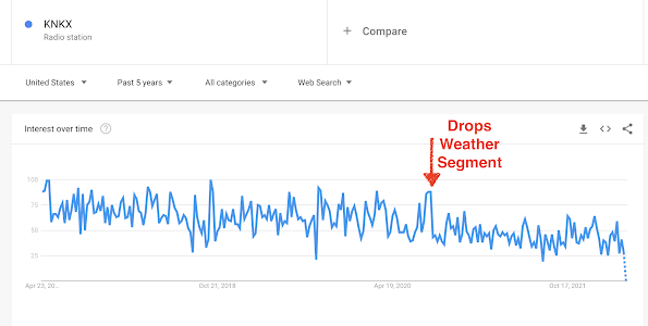
Google Trends provides a tool for viewing the number of searches over time, and the numbers for KNKX are shown below.  

You will notice a major drop in mid-2020 as the editorial policy of the station shifted to pushing identity politics and they ejected their meteorologist for speaking up against the violence in Seattle.  And the online interest in KNKX continues to decline.

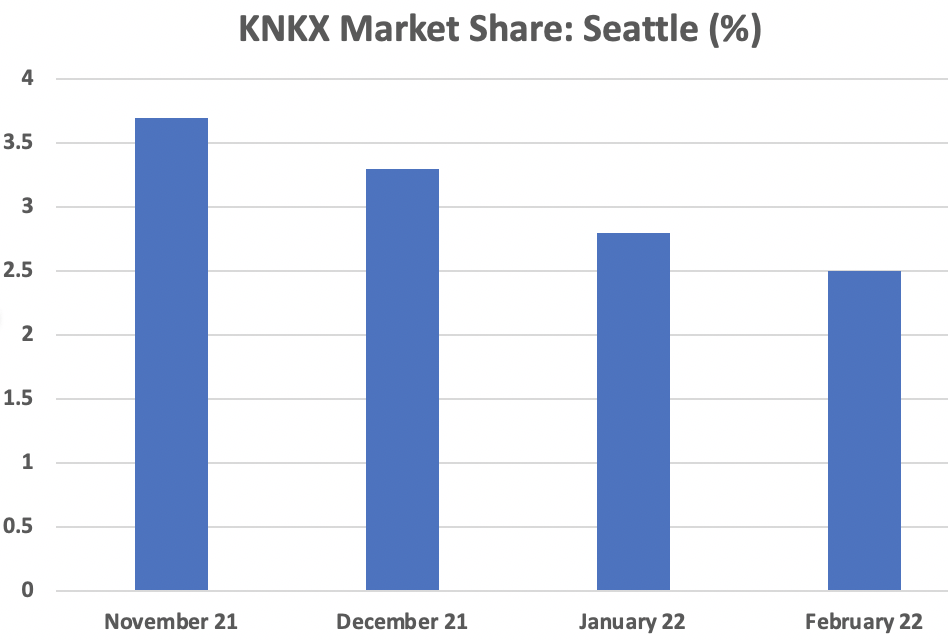
But what about listenership statistics, such as those provided by Neilsen Company?   As shown below, the proportion of the Seattle listening audience tuning in to KNKX (the market share) dropped 40% during the past 6 months from 3.6 to 2.8.   

What about the total number of station listeners, a measure known as CUME?   

A decline from roughly 320,000 to 220,000—a third of their audience is gone.   Last fall KNKX had a funding drive and failed to reach its target—something that never happened before.  No wonder KNKX stopped showing their goals during fund drives.  

A Biased, Partisan Public Radio Station

The management of a public radio station has a responsibility to provide unbiased information to the public, untinged by political advocacy.  A public radio station should not have a social change agenda.  Communicating truth and facts, and providing a venue for discussion and debate should be central.

KNKX management has failed in this crucial arena.   This is easy to prove.

Go to the KNKX public website or load their app, and you inevitably see a front-page with highly racialized, politicized material.   I mean day after day.   Serious news or analysis is rare.  Below are a few examples.  


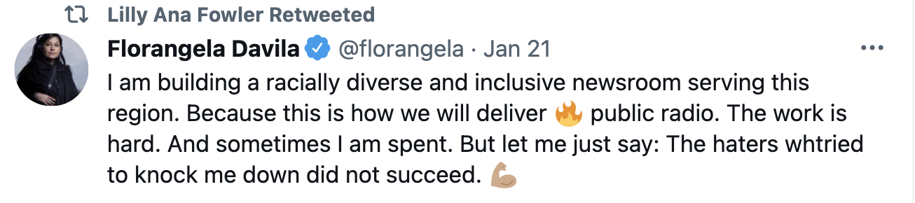
Among the “enhancements” at the station has been the hiring of a social justice reporter, Lilly Ana Fowler, who produces socially “appropriate” material.   This reporter has an active Twitter account where she provides activist materials, such as the statement that the border patrol was whipping Haitians trying to enter our southern border (see below).  This "information" was not true, by the way.

Ms. Fowler has a very strong anti-police stance.

And negative viewpoints about Israel.

Social justice reporters inevitably act as social justice advocates.  I have not seen an exception to this rule.

So we have a radio station that is apparently ok with a news staff member spreading highly political, and sometimes untrue, material on Twitter, but fired their meteorologist for complaining about political violence and defunding the police in Seattle.  Political violence favored by the activist left.

Spot any hypocrisy here?

One knew there was a serious problem when the KNKX program director, Matt Martinez, talked about his racial ideas in an interview on Current.Org, where he discussed “uncomfortable truths about race in public radio.”    In that interview, he complained about KNKX’s “very white audience”, “white-led organization”, “mostly white newsroom”, and “all white announcers.”     Replace white with another race and you see how inappropriate his comments were.

Mr. Martinez hired an activist news director, Flogangela Davila, who has overseen a sea change in KNKX's on-air and online offerings towards a progressive left viewpoint. Ms. Davila has steered KNKX news coverage, both on-air and online, into the politicized outlet it has become.


Mr. Martinez resigned about a year ago, but the current station management reiterated their support of his policies in a public statement in June last year.

The political shift of the station was evident when I was there.   I was told to keep away from talking about climate change because activist organizations (like 350.org) did not like the peer-reviewed science I would communicate.   In fact, these organizations were so upset that I was providing rigorous science in this blog that they demanded that the station investigate my science.   To the eternal disgrace of the station, KNKX management caved in to the demands and made a member of 350.org the leader of the study.  Unbelievable.

Of course, I was "cleared"...my science was solid.  But the fact that KNKX management was so weak that they felt the need to give into activist groups, says everything.


The Bottom Line

There is little doubt why the listenership and readership of KNKX are declining rapidly.  The political bias of the station is obvious, and factual content has declined precipitously, both on-air and online.   KNKX management has a responsibility to provide unbiased, comprehensive information to the public, and they have failed to do so.  And worse than that, their reporting has implicitly supported policies that have led to a rapid decline of the Puget Sound urban environment.

PS:  In my blog of June 2020--the one that got me fired by KNKX--I warned about the impacts of political violence and the terrible error in defunding the police.  Unfortunately, my predictions of increased crime and the decline of Seattle all came true.  And my warning that the most vulnerable would be hurt the most also came true.  


The folks that KNKX activists supposedly cared the most about were hurt the most.  Perhaps KNKX management should think about that for a minute--and their own responsibility for what has occurred.


_______________________

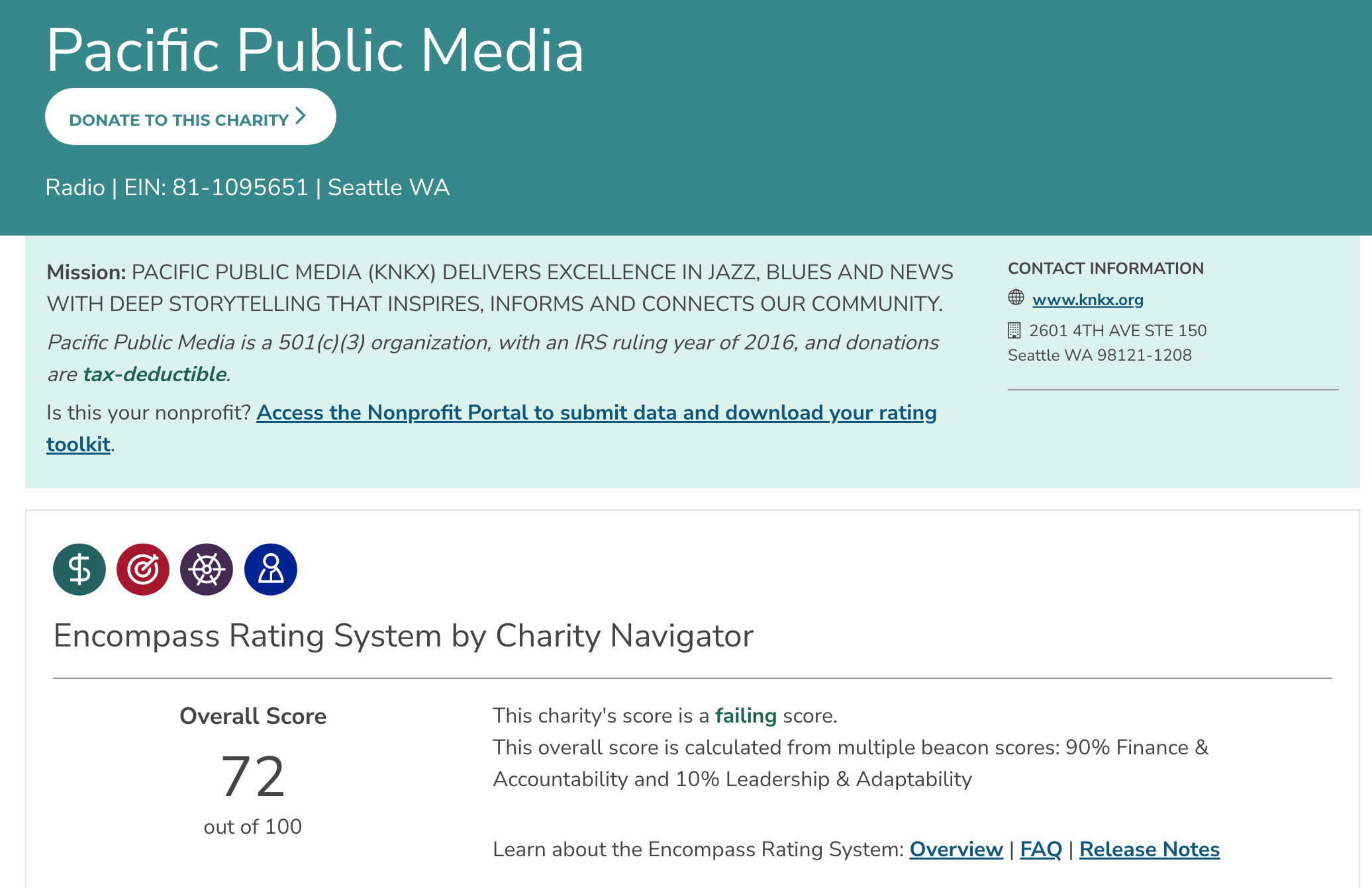
Update:  Charity Navigator, a respected charity evaluator, gave KNKX (Pacific Public Media, its parent organization) a FAILING score.


One issue is that only 58% of contributions were used in programming.  21% went to administration and 21% for fundraising.


KNKX is known for lavish, expensive holiday parties.

Should I Let AI Write My Blogs?

I spend a lot of time thinking about and writing my blogs.   Could AI apps do the work for me?   Could any of you tell the difference? Well,...