March 31, 2010

Stunning Day of Convection and BIG storm coming

There was magnificent cumulus and cumulonimbus today over our region. The reason? A very large change in temperature with height associated with very cold air aloft, coupled with warming at low levels from the increasingly powerful sun. Here is a plot (sounding chart) of temperature and dew point at 5 PM this afternoon at Forks, on the NW Washington coast. This is based on observations taking from a balloon-launched radiosonde. Very rapid temperature decline with altitude.

As the surface heated up during the day, the convection grew and blossomed with some the cumulus forming well-defined anvils. Here is a stunning video from Dale Ireland's cloud cam in Silverdale (click on link or picture to see it):

The developing convection was very evident on the high resolution visible satellite imagery today. Below are two images. The first in the morning when the instability was just developing and the latter in the mid afternoon when some of the convection has grown into full blown cumulonimbus with well defined anvils (which look like oval cottonballs from space).


Beautiful to look at and impressive anyway you care to view it.

Major weather changes are in store Friday and Saturday. Moderate to heavy precipitation over the region...with a very strong low moving just north of us. Winds will be very strong over the coast (40-60 kts), northwest Washington (30-50 kt) and breezy (20-40 kt) over the PS lowlands on Friday. Take a look at a forecast chart of sea level pressure and surface winds at 5 AM on Friday. A 988 mb low right off the WA coast and very strong coastal winds (45 kt sustained). We are talking about a very significant springtime event.

Maybe even the Weather Channel will cover it!

March 29, 2010

Amazing Winds and Convection

Click on picture for Dale Ireland's time lapse movie of today's action.

Its cold, windy, with heavy rain in places. Convective showers are raking the region and heavy snow is hitting the mountains. A winter storm in spring and a savior to our water supply concerns this summer. Last night and early this morning there was some very powerful winds...hurricane force in places...along the coast, over some inland peaks, and eastern Oregon. Here are a few maximum wind reports:

Mt. Hebo, Oregon 3160 ft 96 mph!!!
HURRICANE Ridge 5200 ft 92 mph (there is a reason they call it hurricane ridge)
Mission Ridge 6739 ft 90mph
Humbug Mt. 50 ft 83 mph
Cape Foulweather 1024 ft 81
Garibaldi 75 ft 79mph
Cape Disappointment 140 ft 77
ANTELOPE (eastern Oregon) 6460 ft 77
Cape MEARES 1421 ft 75 mph

Pretty impressive for late March.

But the other story was the substantial instability of the air coming in off the Pacific and convective showers (some very intense) it produced. I got savaged by one on the way home. I knew it was coming from the radar and delayed five minutes too long. I really enjoy cutting it close, attempting to race ahead of an ominous, dark cloud mass.
An important measure used by professional meteorologists to measure instability is called CAPE, which stands for Convective Available Potential Energy (now that will impress your friends). It is related to the most of energy that will be released by a buoyant parcel of air in a column. Here is the forecast CAPE for this afternoon:
Values of up to around 600 offshore with modest values into western Washington. This is good for us...but in the midwest they can get to 3000+. The instability of this air flow is associated with relatively cool air aloft moving over fairly warm water and the heated land. In fact, the greatest instability in our areas tends to be in spring.
Instability leads to convective clouds (e.g., cumulonimbus) and isolated heavy rain and occasional lightning. Take a look at the radar image this afternoon below--some of the showers were very intense (the yellows). You don't bike in yellows. You don't want to know about the reds.

Here is the high resolution visible satellite imagery at roughly the same time. Can you see the instability showers offshore..with the block being the clearing between the cumulus cells. Showers and sunbreaks...a NW classic. This is exactly the kind of pattern that lays down lots of snow. Below is the forecast 24-h snow amounts ending 5 AM Tuesday morning...some locations get well over a foot. City Light should think about revoking their electricity surcharge.


And if all of the above is not enough...there is a high surge advisory along the coast:
A HIGH SURF ADVISORY REMAINS IN EFFECT UNTIL 6 PM PDT TUESDAY.

LARGE SOUTHWEST SWELLS OF 20 TO 24 FEET WILL CONTINUE TO AFFECT
THE NORTH AND CENTRAL WASHINGTON COAST THROUGH TUESDAY AFTERNOON.

March 27, 2010

Serious Rain and Wind

A fairly strong storm for this time of the year is approaching, but the interesting weather will be late today (Sunday). On Sunday there will be sunbreaks and showers for most of the region, with more serious weather arriving later this afternoon. The media has really been hyping this event up.

Take a look at the 24h precipitation ending 5 PM Sunday and Monday (below). Some mountain areas will be getting 2-6 inches, with moderate rain even over the lowlands (particularly late Sunday and early Monday).
And what about winds? Look at the pressure forecast for 11 PM Sunday night. With an intense low far offshore, we still have very large pressure differences in the coastal waters and over NW Washington--which means strong winds. The wind forecast for the same time shows 45 kt sustained water in the coastal waters and 35 kts over NW Washington. Gust could be considerable larger. Time to batten down the hatches and enjoy some storm watching! And the models are showing significant snow above 4000 ft this week.

Springtime Dust storms


During the past week there has been a major dust storm over east Asia, with dust spreading over eastern China, Japan, and over the Pacific. This is not an academic issue for us here in Northwest because occasionally this dust is carried across the Pacific, influencing visibility and air quality over the Northwest.

Take a look at a picture in Beijing before and during the current dust storm above. Pretty amazing change. Visibility can drop to 1/8 mile or less in major events. And such dust storms are very evident in satellite imageryover east Asia a few days ago, as show below. The dust is the tan looking stuff.

East Asian dust storms tend to occur in spring and generally start over the deserts of Mongolia, northern China and Kazakhstan when strong springtime winds lift fine, dry soil particles into the air. Overgrazing, deforestation and drought have contributed to an increase in this phenomenon.

Unfortunately, here in the Pacific Northwest we can feel the effects of major dust storms. The dust can mix high into the troposphere (the lowest layer of the atmosphere which tops out around 30,000 ft) and the strong winds there (the "jet stream") can blow the dust across the Pacific in a few days. Spring is a good time for the dust to make it over since the jet stream is still fairly strong and at the right latitudes for transport from Asia to our region. There have been a number of such events with ones in 1998 and 2001 being particularly memorable. Visibility can plummet here in the Northwest as the Asian dust overspreads the region; take a look at an example below:

One study found that ∼50% of the interannual variability in springtime average visibility here in the NW can be explained by changes in Asian dust emissions.

But the situation is worse than just dust. Not only dust makes it across the Pacific, but so does some nasty pollutants, both on the dust and in the free air. Professor Dan Jaffe, of UW Bothell, is an atmospheric chemist who has extensively studied cross-Pacific transport of pollutants. He has run two Northwest observatories to collect Asian pollutants--one at Cheeka Peak on the northwest corner of the Olympic Peninsula and at Mt. Bachelor, Oregon. He has a nice web page on the Asian pollution and dust transport at http://faculty.washington.edu/djaffe/FAQs.htm

The bottom line of all this is that the atmosphere is highly interconnected and pollution and dust storms half a world away can affect us here in the Northwest.

March 24, 2010

A warm day and then rain

Today was very warm around western Washington, with some stations (like Sea Tac) breaking their all-time daily record. Now let me make one thing clear...breaking a daily record is not that unusual. We break a few of them every year for highs or lows. Breaking monthly or all-time records like last summer's 103F...THAT is impressive.

Here is a map showing the temperatures at 3 PM..near the time of highest temperatures (note: you can click on it to expand). You will note that some of the warmest temperatures (70-72F) are on the east side of the Puget Sound basin away from the water. You will also note some easterly flow.
Today was a good set up for warmth. First, we had only limited high clouds and sun is fairly strong now--the same sun as mid September. Second, we had an approaching trough that brought southerly flow and relatively warm lower-atmosphere temperatures into the region. To see this, take a look at the temperatures and winds at around 5000 ft for 10 AM Wed morning, shown below. The solid lines are the heights of the 850 mb pressure surface...think of it as like pressure, with the winds roughly parallel to the height lines. You can see the southerly winds bring warmer air (reddish colors) into our region. You will also notice the easterly and southeasterly flow over the Cascades. Easterly flow adds to the warming because air warms as it sinks and is compressed. That is why the warmest temps are over the Cascade foothills and the east side of the Sound.


But the warmth is over now. As seen in the satellite image below, a front is now entering the region and tomorrow will only reach the mid-fifties and there will be light rain. And we stay in a cooler, wetter pattern for a while, which will include some needed snow in the mountains.

March 23, 2010

Will Issaquah Pick Poor Math Books?

Issaquah and Sammamish are home to a well educated population, many of which are employed in professional and high tech occupations. Thus, it is surprising that the Issaquah School District administration is doing everything possible to place very poor math books in its schools.

Tomorrow (Wednesday, March 24) night the Issaquah School Board will vote on the administration's recommendation for the Discovering Math series in their high schools. These are very poor math texts:

(1) Found to be "unsound" by mathematicians hired the State Board of Education.
(2) Found to be inferior to a more traditional series (Holt) by pilot tests by the Bellevue School District
(3) That have been rejected by Bellevue, Lake Washington, North Shore, and Shoreline (to name only a few)
(4) Whose selection by the Seattle School District was found to be arbitrary and capricious by King County Judge Spector.
(5) That are classic, weak, inquiry or "reform" math textbooks that stress group work, student investigations, and calculator use over the acquisition of key math skills.

The Issaquah school administration is trying to push these books through with little input from parents or other interested parties. Their curriculum committee has only teachers, and fairly inexperienced ones at that, with no parents allowed. The Superintendent is actively lobbying for the books. One of his big arguments is that Discovering is consistent with the current (very poor) math books they already have.

If you want more information on this potential disaster for district kids, please go to:

http://saveissaquahmath.blogspot.com/


If these books are approved, it will be very, very difficult for any Issaquah child to secure a decent math education. It is critical that parents and interested parties attend the board meeting tomorrow night and email their board members (schoolboard@issaquah.wednet.edu) and the Issaquah Superintendent. If the wrong books are selected, the damage will continue for another decade, unless a parent lawsuit ensues.

Meeting info:

The board meeting will start at 7:00 PM at District Offices. Public comments will be taken before the vote.

March 21, 2010

Summer Outlook

A number of you are asking about the outlook for the summer. Warm summer again? Drought conditions? El Nino effects?

The bottom line is that my ability and the ability of my colleagues are very limited in such predictions---even though seasonal forecasts are made by the National Weather Service.

Weather forecasting skill, the ability to predict the specific weather situation, fades out between five and ten days into the future. Numerical and theoretical studies demonstrate that we are unlikely to have forecast skill of specific weather features beyond 14 days. So don't believe the Farmer's Almanac.

But it is possible to have limited prediction skill beyond two weeks for the average conditions in the future, such as whether an upcoming season will have temperatures above or below normal.

The National Weather Service's Climate Prediction Center provides monthly and seasonal forecasts of the mean or statistical properties of the atmosphere. Their most important tool is the correlation of U.S. weather with El Nino/La Nina with midlatitude weather conditions. They have others: current soil moisture and snow distributions, the current and predicted states of other major atmosphere or ocean variations (e.g., the Pacific Decadal Oscillation, and Arctic oscillation, etc), and other parameters. Their predictions really don't verify that well, but have marginal skill.
I should note that El Nino/La Nina correlate fairly well with our winter weather (as shown by the low snowpack during this El Nino year), but it has minimal value for predicting summer weather.

So here is their latest NWS forecast graphics for temperature and precipitation for June, July, an August:
Their call: warmer than normal and drier than normal. Basically persistence.

But quite frankly, I would not bet the farm on such predictions, their skill is marginal.

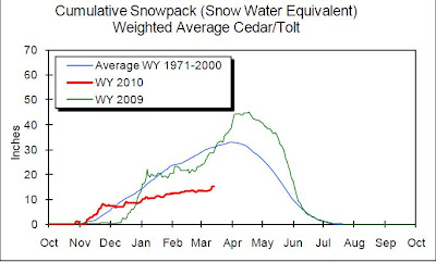
But there some things we do know. As shown in the map below, our snowpack is well below normal--roughly 65% of typical values at this time of the year. Not a disaster, but low. Looking at the weather models for the upcoming week, you cannot expect us to get anything significant during the next five days.

This is enough snowpack to insure plenty of drinking water this summer, and in fact because of smart management and nearly normal winter precipitation (much of it rain), the water in Seattle reservoirs are above normal (see graphics).


It does look like agricultural and fish will suffer from below normal snowmelt this spring and summer. But you never know....

March 20, 2010

Warmth

Update at 6 PM. Really got toasty today....upper 60s to 70 on Puget Sound eastside and the southern Sound. But clouds are now rolling in now . I went cross country skiing at Blewett Pass today on the eastern slopes of the Cascades. At 4000-4800 ft there was snow, but it wasn't pleasant in many spots. Icy in the shade, rutted and full of holes everywhere. Spring skiing (which is ok) in the sun. Driving across Snoqualmie Pass, conditions looked pretty marginal. On the other hand, my vegetable garden is doing well and my pea seeds germinated in the warming soil.


Today will be very warm west of the Cascades. With offshore flow this morning and southerly flow this afternoon, temperatures will rise to the mid-60s in many locations, and at some upper 60s, approaching or reaching daily records. Probcast, the statistical package that works with ensemble forecasts (www.probcast.com), is very good at high temperatures under full sun...and here is the prediction for max temps today:


Note the cooler temps on the upslope (eastern) side of the Cascades. Another thing that is helpful is that the sun is much stronger now (equivalent to the middle-end of September!). And only some scattered high clouds to intercept the solar radiation.

Tomorrow things will go downhill...so today is the day..

March 18, 2010

Diurnal Variations


Now we are in a dead weather period (no precipitation until Sunday), it is good time to look at the typical daily (diurnal) variations of various weather parameters. One of my favorite charts is shown above...a 24-hr plot of the surface observations at a station (in this case Seattle Tacoma Airport) for the past day (ending Thursday afternoon). Time is in UTC (aka GMT or Z time), subtract 7h to get PDT (12 UTC is 5 AM, 00 UTC is 5 PM). The top line is wind speed....sustained (black) and gusts (red). In meteorological parlance sustained winds are usually averaged over 2 minutes, with gusts defined as the highest 3 or 5 second wind during that period. Why are their gusts? Generally from the turbulent mixing of higher winds down from aloft.

Notice something about the winds? They tend to be stronger during the day. Why? As discussed in an earlier post, there are several reasons, the most important being the atmosphere is less vertically stable during the day when the ground is being heated. As a result there is more mixing of higher winds from aloft.

Temperature and relative humidity are mirror images of each of other. The reason? When temperature increases the air has more capacity hold water vapor. Since relative humidity is the amount of water vapor in the air divided by its capacity, increases temperature (and thus increasing capacity causes the RH to drop).

What about pressure at the surface? Here is an interesting thing. If there are no weather systems over an area the surface pressure still changes! There is a typical diurnal cycle with pressure being higher at 10 AM and 10 PM and lowest at 4 AM and 4 PM. The highest high is 10 AM (+or- one hour) and the lowest low at 4 PM. Why? The biggest forcing is the diurnal tide in the stratosphere. It is like a lunar tide in the ocean (two highs and two lows), but instead of being forced by gravity, it is the heating of the stratosphere that does the forcing.

You can see the solar radiation at the bottom. It looks like a cosine function (for those of you who remember your trig), with the few imperfections in the shape due to clouds.

Finally, the second strip of observations is wind direction. Not how it flops around when the winds are light. In fact, you really can't believe wind direction for most wind vanes until the winds get above roughly 2-3 knots.

Finally, you can help in an important study:

A group of UW graduate students created a survey directed at western Washington residents with two main goals:

1) Determine how often, from where, and why residents seek weather information
2) Determine residents' level of understanding associated with weather terminology

The information gathered by the questionnaire will help guide more effective techniques for communicating important weather and flood information. The following link connects to the survey. Thanks for considering this.

http://www.surveymonkey.com/s/G3FKPDG

March 15, 2010

Radar Secrets Revealed

Today I can reveal some information that has been under wraps for a while: the suggested location of the new weather radar on the Washington coast.

As many of you know, a coastal radar has been a dream of Northwest meteorologists for a long time, a device that will improve warnings and forecasts, improve our quality of life, and save lives and property. The acquisition of the radar wasn't going anywhere until Senator Maria Cantwell, reacting to the public concerns about the major storms of 2007, worked to secure the necessary funding (9 million dollars in total) last year. Intense interest by the public, the media, and local business and environmental groups also helped. The National Weather Service is now solidly on board with this acquisition, with enthusiastic support from local offices and NWS Western Region.

Using some initial funding from the Stimulus Bill, the National Weather Service hired an experienced firm, SRI International, to do comprehensive site surveys. At the same time, the University of Washington ( specifically Dr. Socorro Medina, with consulting from Professor Houze and myself) took advantage of sophisticated radar simulation software to look for excellent sites. These sites were passed to SRI, who investigate many of them. A good site had to have:

1. A clear view out to the ocean, including the entrances to the Strait and Columbia Gorge.
2. Good views towards the Olympics and SW Washington to see the precipitation on their windward slopes.
3. Good views over the coastal zone.
4. Heavy duty three-phased power nearby, plus a high-bandwidth communications line.
5. A lack of nearby obstacles and no electromagnetic interference.
6. Accessibility over a reasonable road.
7. And more (e.g., nearby good coffee)

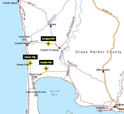
After a great deal of discussion, three potential sites were identified, with the one of choice being Langley Hill (see map below). Two runner up sites were Ocean City and Saddle Hill (also on the map)


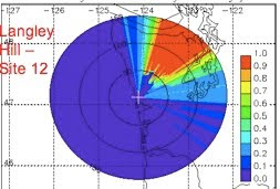
Here is the simulation of what the radar would see for a low scanning angle--.5 degrees.
(Some radar 101: the radar scans in azimuth (0 to 360) at a certain elevation angle above the horizontal. Typically the lowest angle used by the NWS is .5 degrees, but virtually all meteorologists in our area want this radar to start at 0 degrees...to see farther out).
This is GREAT coverage: beautiful view offshore. Olympics cause blocking...but that is fine--we can see the rain on the wet SW slopes and the Camano Island radar can see the other side.


The full report (see below) has lots of pictures and information on the site. Power and communication is only 500 ft away and it is on top of hill owned by a local timber company. Not sure about the coffee. I should note that once operational the radar will be unmanned.

If by some chance the NWS can't acquire that site, we have other viable choices.

If you would like to read the full report, it is found at:

http://www.atmos.washington.edu/~cliff/Radarsiting.pdf

You can also find a copy at the Seattle NWS web site.

The next stop will be deciding on the radar specifications, ordering the unit, and deciding on its scanning strategy. There are some issues regarding this right now, with the UW and local NWS meteorologists wanting to optimize the scanning approach for our needs, while some radar NWS HQ types wanting the unit to work like the rest. But more on this later. But whatever happens we will have a marvelous piece of hardware: state of the art, high powered, dual polarization (which the rest of the country doesn't have yet) and more.

March 13, 2010

I want a home weather station? What should I buy?

One of the most frequent questions I get is from people wanting to set up a weather station in their home. What should they buy? Where should they install it?

Lets try to tackle these important questions.

Having your own weather observations is really marvelous. There are very large variations in weather locally and you CAN'T assume that your home or apartment has the same conditions as Sea-Tac airport or one of the limited collection of stations presented on TV or in the paper. A few years ago I ran around the city with a bunch of 101 students in specially instrumented cars--temperatures varied by 15-20F on a cold winter night! (the graphic is in my book if you are interested). Having your own observations can help calibrate your gardening...when to put in or protect that delicate plant. Taking weather observations really brings you closer to nature, makes you more sensitive to natural rhythms and variations, makes you a better observer, and has a calming, salubrious effect on your disposition. Yes, weather observers are a happier lot.

One of the great revolutions of the last decade has been the availability of a wide range of weather instrumentation at a reasonable cost, some with near-professional calibration. And the second revolution has been the distribution of many of these observations over the internet. Tens of thousands of individuals around the U.S. put their observations online in real-time, and these are viewable on sites such as weatherunderground.com.

So what should you buy? Well, if you want to invest in very good equipment, we have found that the Davis Vantage Pro hardware is really excellent (see image above). This system can cost you $ 500, but you can often do better with a little internet shopping. If you have extra cash I was get the aspirated thermometer (solar powered fan for the enclosure). You can also get software for connecting the unit to your computer.

Now what if you don't have so much $? No problem. You can buy inexpensive gear with less accuracy that still can tell you a great deal. For example, COSTCO sells Oregon Scientific and LaCrosse weather stations for $ 100-200, with similar prices from others over the web. But you get what you pay for. And many of them have unshielded thermometers, so BE SURE to put then in a shady location on the north side of your residence, out of the rain.

Out of work or just on an allowance? No problem again. You can buy a digital thermometer or an alcohol one for $10, a rain gauge for $5-10, a cloud chart for $5, and a barometer for $25.00. And a pad to record your observations. That is how I started. As did Thomas Jefferson.

For the computer oriented, getting your weather station interfaced with a computer is great fun, and the interfacing software often comes with neat archival and plotting software. But the fun doesn't stop there. You can automatically send your data to groups such as weatherunderground.com so you and others can view it online. In fact, even if you don't have a weather station, you can often get a close-in weather view for your location by going to that site. The map below shows the weatherunderground observations right now (10 AM Saturday) over a small portion of Seattle.

There are other collections of volunteer weather observations, which are generally less user friendly. One is the Citizen's Weather Observer Program (CWOP) http://www.wxqa.com/.

But let me make one thing very clear. The quality of these volunteer and hobbyist observations vary widely in quality. Some are very good. Some are very bad. Why bad? Generally poor exposure and placement.

Temperature should be measured in the shade or in a protected (white) enclosure at 2-meters above the surface. Rain gauges should be in the open, not near splashing roofs or protective trees. Winds should be taken on masts that are not near buildings or trees (and not a the peak of roofs where wind is accelerated). You get the message.
One of the great challenges for professionals like me is how to use this varied, heterogeneous dataset.

So have fun taking your own observations!

March 12, 2010

Wind and Snow


Its Friday morning and the front has just gone by. That is evident from the end of the moderate showers (see the radar image above) and the wind shift and pressure rise at Destruction Is on the Washington coast (see table).

Beautiful image of the front and the associated offshore low in the latest infrared satellite image (see below).The wind is about to pick up substantially as the low pressure center offshore moves across Vancouver Island into southern BC (see forecast surface wind chart for 10 PM tonight below). This configuration produces a large north-south pressure difference over our region and thus accelerates the winds. Winds will gust to 20-30 mph in the central sound and perhaps 40-50 mph over NW Washington (Strait of Georgia, northern Whidbey Island, San Juans). In fact, the winds are already starting to crank up there (Whidbey Island Naval Air Station gusting to 35 knots, 36 knots at Paine Field). Over the sound the winds are also strong (41 knots last hour at Alki). And strong winds along the coast.

But wind today and tonight is only half the major weather story. The other is snow.

During the past day there has been a major snow dump in the mountains (see pictures on I90 yesterday). Many locations have gotten a foot of snow and snow showers are continuing today (perhaps another 1/2 ft). This would be an excellent weekend for some skiing....but one major warning. There is a substantial avalanche threat with so much snow falling so quickly on a rather icy, hard-pack underlying foundation. If you are going into the mountains, and particularly if you are straying from controlled areas, check the Northwest Avalanche Center's excellent website
http://www.nwac.us/

All this rain and snow is a very good thing. Lets face it, the Northwest's key resource is water...for energy, agriculture, fisheries, timber, and consumption. Its why it is better here than California. The large influx of moisture this week will have a significant positive impact on the snowpack and reservoir levels.

March 09, 2010

Seattle, Bellevue, and Issaquah: School Districts Versus Good Math Education

Major Update: Tonight (Thursday night) the Bellevue Math Adoption Committee voted to adopt Holt instead of the Discovering Math series. This is extraordinary good news and one can assume that school board will follow suit. It was clear to those attending that the massive intervention of Bellevue parents was a major factor. The School district received over a 100 comments, most in support of Holt, and a new analysis by Bellevue parent Jock Mackinlay of the piloting data showed the clear superiority of Holt in supporting student learning. Active, determined parental intervention can make a huge difference and it happened in Bellevue tonight. One can also thank the district for leaving ideology behind and using real data and parental wishes as guides for their actions. Now all eyes turn to Issaquah, which is now in the midst of making the same decision. And for me, back to weather!


If you are a parent in cities such as Bellevue, Issaquah or Seattle, your kids are being short-changed--being provided an inferior math education that could cripple their future aspirations--and you need to act. This blog will tell the story of an unresponsive and wrong-headed educational bureaucracies that are dead set on continuing in the current direction. And it will tell the story of how this disaster can be turned around. Parent or not, your future depends on dealing with the problem.

Let me provide you with a view from the battlefield of the math "wars", including some information that is generally not known publicly, or has been actively suppressed by the educational establishment. Of lawsuits and locking parents out of decision making.

I know that some of you would rather that I only talk about weather, but the future of my discipline and of our highly technological society depends on mathematically literate students. Increasingly, I am finding bright students unable to complete a major in atmospheric sciences. All their lives they wanted to be a meteorologist and problems with math had ended their dreams. Most of them had excellent math grades in high school. I have talked in the past about problems with reform or discovery math; an unproven ideology-based instructional approach in vogue among the educational establishment. An approach based on student's "discovering" math principles, group learning, heavy use of calculators, lack of practice and skills building, and heavy use of superficial "spiraling" of subject matter. As I have noted before in this blog, there is no competent research that shows that this approach works and plenty to show that it doesn't. But I have covered much of this already in earlier blogs.

The administrations of three major local districts--Seattle, Issaquah, and Bellevue--are all pushing the Discovering Math series (by Key Curriculum Press) for their high schools. These are very poor books, found mathematically unsound by mathematicians hired by the State Board of Education. Superintendent of Public Instruction Randy Dorn did not recommend Discovering Math, but explicitly stated that ONLY HOLT high school math was acceptable of the reviewed texts. I have read through the Discovering books myself and invite you to review them as well--it is difficult, if not impossible, to get a good foundation in key mathematics from the Discovering Math series. Each of these districts are finding ways to marginalize parents and steer the process to secure the desired end.

Parent feedback in every forum I have attended has been overwhelmingly against this book series by wide margins. As are public comments on the internet.

Seattle

The big story, in the state's largest school district, is that King County Judge Julie Spector handed down a ruling about a month ago, stating that the Seattle School Board was arbitrary and capricious in deciding to select the Discovering Math series. Essentially, she stated that no reasonable board member would be able to pick Discovering with the evidence that they had before them and that they needed to go through the process again. She did not tell them which book to pick, rather that what they had done was not reasonable--something many of us had been saying for a long time. This was a neutral jurist with no axe to grind.

Last week, the district decided to appeal the ruling. Not because the books were good, but because they didn't like a judge telling them that they had messed up. Two school members (Michael DeBell, Kay Smith Blum) stood against the appeal to their credit, but they were outvoted by the rest (except Betty Patu who was absent). A major issue is whether school board members have any real function or responsibility. Are they there to judge whether the district is doing the right thing or simply there to insure that a process was followed?

The Seattle ruling has had a large national impact, emails are pouring in from around the U.S. and the ruling was even discussed in Scientific American and newspapers around the country. The publisher Key Curriculum Press even created a website on the decision that is full of untruths (http://www.keypress.com/x24956.xml). A big one is the statement that it is our "contention that offering students of color anything other than a diet of “explicit instruction” is “racist.”" Go to their list of "mathematics professionals" in support of their curricula. The first is Dr. James King of the UW (he teaches math education classes). This gentleman is a fierce supporter of discovery and reform math approaches and set up a web site ("wheresthemath.org") designed to confuse individuals looking for my groups website ("wheresthemath.com"). And he is a Key Curriculum author. So much for unbiased viewpoints on that website! This publisher is now emailing teachers around the country trying to stir up support for their books.

Interestingly, Key Curriculum Press sued the State of Washington, because Superintendent Dorn only supported the Holt textbook. They lost a few weeks ago. But because of the lawsuit, the Superintendent's office has been muzzled by the State Attorney General's office and is still muzzled because of a worry about an appeal. So Key Curriculum has prevented OSPI (Office of the Superintendent of Public Instruction) from making it explicitly clear that Discovering is
unacceptable. They got what they wanted.

Bellevue

Many look at Bellevue as one of the flagship districts of our state--rich, highly educated, full of high-tech types who value education. Surely, they wouldn't pick a weak, "unsound" math curriculum! But they seem hell-bent to do exactly that.

Bellevue set up a math adoption process (see http://www.bsd405.org/portals/0/curriculum/mathadoption/index.htm for their website), centered around a math adoption committee of 24 Bellevue School staff and 4 parents. No math or technical professionals. A parent representative on the adoption committee made it clear to several of us that the committee discussions were clearly biased towards Discovering. They held four "information sessions" in which parent feedback or comments were not allowed (hard to believe but true). They also piloted both Holt and Discovering math in some schools.

The PTSA set up a meeting to discuss the math adoption and invited district reps and parents and others with interest in the subject. A few days before the meeting, Judge Spector ruled in favor of Seattle (see above), finding that the adoption of Discovering Math was done in an arbitrary and capricious way. Hours later, the PTSA president, after talking to district officials and others, decided to cancel the math information gathering. The district offered to set up another meeting, but only if parents were not allowed to comment or provide testimony. Disgusted by this, a group of parents set up another gathering on February 24, inviting the district to send reps to provide their viewpoint. None of them showed, not event the Bellevue Superintendent who promised to be there. But the crowd was huge, with roughly 120 parents in attendance. The overwhelming majority of them were dead set against Discovering and frustrated that the District had little interest in their feedback.

Recently, the results of the Holt/Discovering pilot in Bellevue Schools were released, one in which the students took the same diagnostic test (based on the current, mainly reform/disovery type of learning). Bellevue parent Jock Mackinlay put together the following summary of the results for Algebra (red indicates Holt was superior):


The results are clear. Holt is compellingly better than Discovering Algebra based on this pilot.

There is so much more I could share, but I will leave it at that. Bellevue parents need to educate themselves about this potential disaster and contact their school board members and Superintendent immediately. They will be making the decision later this month. Will Bellevue adopt a book found unsound by the State and which tested worst in their own trials?

Issaquah

Another highly educated and high-tech community, whose administration is determined to adopt Discovering Math. Their Curricular Area Review Committee (CARC), which has no parents on it, voted unanimously in support of the Discovering Math text series and District Superintendent Rasmussen distributed a letter strongly in support of Discovering Math (http://www.issaquah.wednet.edu/documents/math/HSmath/communitymath.pdf). Much of this letter is full of misinformation. For example, in contrast to this memo, OSPI only supports Holt, Discovering is excluded. I have confirmed this with OSPI.

Recently, one of the top international experts on learning (Psychology Professor Paul Kirshner, Director of the Learning and Cognition Program, University of the Netherlands), commented on Issaquah's adoption of Discovering Math, noting that that studies of long and short-term memory indicate that such approaches are generally ineffective.
( see http://www.wheresthemath.com/Pages/Where%27s%20The%20Math.aspx)

Issaquah now has very poor reform books in the elementary school and middle school level (Everyday Math, Connected Math). If you go to the Issaquah math adoption page you will amazingly read that this is in fact a reason to go with Discovering Math:

"EveryDay Math in K-5, Connected Math from 6th through Algebra 1, and Discovering Mathematics from Geometry through Calculus. Dr. Steve Leinwand, Principal Research Analyst, American Institutes for Research, also works with our district on the Microsoft Math Project. Dr. Leinwand stated that: "For a district using Connected Math, I believe that the Discovering Algebras and Geometry are a more appropriate continuation of the middle school program than the Holt series would be. Holt is a good traditional program that aligns well with a traditional middle school program. I believe that students coming from a Connected Math experience will be better supported by the Discovering Mathematics books at the high school level."

Translation: If students don't know the fundamentals of real math because they have had discovery curricula in K-8, they need to stay with reform/discovery math the entire way through. If his advice is followed, the damage to the math education of those children would be profound.

A good source of information about the math situation in Issaquah is:
http://saveissaquahmath.blogspot.com/

The vote on the Issaquah math adoption is only days away, so again, parents need to contact their school board members immediately.

In Summary

Although a number of districts have moved away from discovery math (like Shoreline and Northshore), three major districts have either adopted the Discovering Math series (Seattle) or seriously considering it (Issaquah, Bellevue) even though OSPI is not recommending it, the State Board of Education mathematicians found it unsound, and piloting in Bellevue demonstrated its inferiority. Why such irrational behavior? Because many in the educational community are believers in discovery approaches, based on a near religious zeal. And many were taught to believe it in Ed Schools. Education in the U.S. is in deep trouble, a fact noted increasingly by the popular press and experienced every day by parents. It is the responsibility of parents and for the community to intervene.

March 08, 2010

SNOW!! And the Faucet is about to turn on....

As predicted, some snowflakes were flying today around the Puget Sound lowlands, with dozens of reports from southwest Washington to Bellingham. See the video of snow in Federal Way: http://www.youtube.com/watch?v=sdfKPEM78xM

Several people asked how it can snow when temperatures were about freezing--in some cases with temperatures this morning in the upper 30s and lower 40s. Although today was somewhat on the extreme end of warmth for snow, there are few things to keep in mind:

(1) It takes about 1000 ft of above-freezing temperatures to melt snowflakes and today there was a large change in temperature in that thousand feet!

(2) The melting and evaporation of snowflakes in convective showers can cause the freezing and snow levels to drop rapidly.

A weak convergence zone kept the snow showers going for much of the morning and early afternoon, but now it is over. For awhile.

With clear skies and cold air over us, it is going to be REALLY COLD tonight, with temperatures falling into the 20s away from the water. Protect your delicate plants.

But the next round of fun is approaching. As shown in the latest infrared satellite photo a Pacific front is heading eastward towards us.

Rain from this system should reach the lowlands around dinnertime tomorrow and move through over night. This will be followed by a break into Thursday when a much more potent and far wetter system will reach us. Take a look at the predicted 24-h rainfall ending Friday at 4 AM (black is 2.5-5 inches!):

and 24-h later:


This is serious rain for the Olympics and north Cascades. Seattle City Light should be getting substantial precipitation behind their Ross Lake dam...perhaps they will be able secure lots of $ from California after all! The mountains will be getting substantial snow later this week, and there are more wet weather systems after that.

March 06, 2010

The Big Wet Chill

Well, we were all getting a little smug about this spring.

Day after day of warmer than normal temperatures, bulbs and trees blooming roughly a month early, and drier than normal conditions. El Nino winter was here and Seattle City Light and others worry about the low snowpack and lack of water for power generation. Summer had to be just around the corner.

Not so fast! Mother nature has other ideas...a big, wet chill is approaching and some of you, particularly those at higher elevations, may even see snow showers.

Lets review where we are. The following graphs show the temperature and precipitation conditions at Sea Tac Airport, with comparisons to normal conditions, for the past 4 weeks. You will notice that for nearly every day temperature was above normal (Saturday got to 59F, normal is 51) and rarely have nighttime lows fallen to the average values. Observed precipitation (red) is roughly two inches below normal.

The reason for our benign situation? The jet stream has been splitting with most of the action going south of us. Classic El Nino configuration...and this has been an El Nino year. Not global warming.

But this delightful situation is all going to change in a major way.

Sunday a weak front will approach and you can see it clearly on the latest satellite image.We will progressively cloud up during the day, with showers later in the afternoon and and tomorrow evening over the interior lowlands. Behind the front is MUCH colder air (see graphic of low level temperature--blue is cold--and sea level pressure). Thus, the snow level will plummet and by tomorrow evening it will be all snow in the mountains. There is the possibility of a weak Puget Sound convergence zone tomorrow night and Monday AM, bringing showers and perhaps a few snow showers to the lowlands. Monday and Tuesday will have showers before the next frontal system comes in late Tuesday. Temperatures rise with that Tuesday front and fall in its aftermath. The models even show some snow showers reaching the surface in a few locations on Wednesday (see graphic)...but I wouldn't bet on that now. Later in the week we get into a warmer, wetter pattern with southwest flow aiming at our region (see flow at midlevels below, winds are parallel to the lines).

What we do have now is a much stronger sun, so even with cold air over us, our maximum temperatures will be able to reach the forties. Remember, our sun now is equivalent to that of late September!

Let me note that what is happening is not that unusual
. A number of El Nino years have had warm and relatively dry late winters, only to be followed by a cool, wet spring that saves us. That is why it never pays to panic about water supply in March. But it is of course prudent now for dam operators to save all the water they can--little risk of floods at this point.


Bottom line: cool and wet week. January in March. Protect your delicate plants. Skiing will improve by mid-week. And perhaps Seattle City Light will get enough water to stop the threatened rate increase.

March 02, 2010

Why was my flight so bumpy? Part II


Well, as long as I am terrorizing all of you with tales of flight turbulence, I might as well be complete!

In my last blog I talked about the number-one source of turbulence in the skies, shear-induced turbulence. When such turbulence occurs outside of clouds it is often called clear air turbulence or CAT.

But there is another source of aircraft bumps that is often felt around here...mountain wave turbulence. Ever notice that when flying across the Rockies that sometimes the plane is rocking over and immediately to the east of the mountain crest? Or have you experienced lots of bumps flying into Denver? Mountain Wave Turbulence could be the cause!

As shown in the figure, when air moves over mountains, waves can form. Quite simply, when air is pushed up it often oscillates up and down. These oscillations can spread downwind or can propagate vertically. As these waves move up into less dense air then can amplify causing increased shear (and turbulence) or they can break (producing strong turbulence). One sign of such mountain waves are lenticular clouds (see picture at the top). Mountain wave turbulence can sometimes become severe, but generally it is light to moderate in intensity. But every once in a while you hear about jets crossing the Rockies that are jolted by the strong stuff, with people and belongings being thrown to the ceiling.

Interestingly, the Cascades generally don't produce strong mountain wave turbulence because they are too narrow, but there are exceptions to the rule. During strong easterly flow and Enumclaw-style windstorms (see my book for details), moderate to severe turbulence can occur over and to the immediate west of the Cascades.

Another important source of turbulence...but one not as frequent here in the Northwest... is convection....big cumulus and thunderstorms. With strong up and downward motion and large wind shears, such convection can produce moderate to severe turbulence. But pilots know this and generally keep a safe distance, something made easier by weather radar on most big planes.
Remember the NW Weather Workshop!!
http://www.atmos.washington.edu/pnww/

A Near Perfect Forecast of Yesterday's Event. The Next Windstorm Comes into View

 The next time someone makes a weatherperson joke, remember the nearly perfect forecast for yesterday's wind event over Washington. No l...