June 30, 2015

The Water Super Heroes of 2015: Northwest Reservoir Managers

There are heroes walking among us.

Folks that have made critical decisions that have resulted in sufficient water this summer for people and crops.  Individuals who made hard calls that will allow us to deal with the snow drought of 2015.

Who are these new superheroes?   Local reservoir managers at the the Bureau of Reclamation and the Seattle Public Utilities, to name a few.

The most important agricultural area in Washington State is the Yakima River Valley, where irrigated agriculture produces huge amounts of apples, cherries, hops, vegetables, and other crops.  The U.S. Bureau of Reclamation controls the Yakima  reservoirs, which store water for use during the summer. These reservoirs also protect the Yakima drainage from floods, particularly during spring when large amounts of melting snowpack flow into the streams and rivers.  The Bureau of Reclamation has an online "teacup" graphic that shows the current status of the 5 reservoirs (see below).


Now let me show you a stunning figure.  An amazing figure.   One that shows you the results of the heroic folks at the Bureau of Reclamation.    Something the media hasn't picked on.   

The red line in the figure below shows the total storage (the sum of all five reservoirs) for an average year by month.  Generally, the reservoirs are kept quite low during the winter so that there is plenty of space to fill during the spring and early summer as the Cascade snowpack melts.  The reservoirs generally peak in June and then rapidly fall as the snowmelt fades and as water is needed for irrigation during the hot summer months.

The green line is the previous year's (2013-2014) reservoir values.  A bit above normal but following the typical annual variation.   
But look at this year (blue line).  Something VERY different has happened.   During November, Bureau of Reclamation managers made a daring decision.  They knew the snowpack was not building up as normal,  that the Pacific was warmer than normal, and that seasonal forecasts were for warm conditions and less snow in the mountains.  They knew that normal precipitation was predicted. So they made a unprecedented decision to begin storing large amounts of water starting starting in late November and continued to do this all winter.  

As a result, by late winter they had saved unprecedented amount of water in the Yakima reservoir system, a total exceeding the normal peak in June.   Specifically, starting in early April they had roughly 50% more water than normal in the reservoirs and during the subsequent months they released water to make up for the lack melting snowpack.  

Today, the last day in June, the Yakima reservoir storage is a bit more than 80% of normal-- a real triumph.  Sufficient water exists to main required flows in the Yakima system into early September, which will allow sufficient irrigation for all the main crops.  Also helpful was a week of rain in May and the decision of the Roza Irrigation District to forgo water deliveries for a few weeks in May.

To put it another way, with  a severe lack of snow in the mountains and warm temperatures--the conditions expected in roughly 2070-- agriculture in the the Yakima basin will not be hurt by much.   In fact, near normal crops are expected, as shown by recent headlines in local newspapers.  This is extraordinary.


Someone or some group in Reclamation deserves a medal.

And here in Seattle, managers at Seattle Public Utility also made some aggressive calls, storing more water than usual in April and May, when rain was still failing (see red line below).  Here is a plot of this year's snowpack above Seattle's reservoirs...pathetic.


And here is the combined reservoir storage serving Seattle--you can see how they maxed the reservoir levels out April.  A problem is that the demand for water is great because of the warm conditions and the reservoir levels are falling quickly.  Seattle does not have any water restrictions right now, but considering the trend, it might be wise for SPU to ask Seattle residents to voluntarily reduce their water usage.

The bottom line is perceptive managers of our local reservoirs can make a huge difference in helping us get through this warm year with little snowpack.  

We are now undergoing a 2070 climate stress test and you know something?   
We just might pass.  

R stands for reservoir

June 28, 2015

Heat Surge Hits Eastern Washington. The Highest WA Temperature Ever Observed?

As suggested by the high-resolution weather prediction models, temperatures surged over eastern Washington on Sunday, at the same time clouds and showers were giving western Washington some relief.

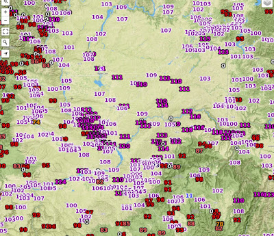
Take a look at the maximum temperatures on Sunday over eastern Washington (below).  The entire region was about 100F and MANY locations (dark purples) got above 110F.   Stunning.


Here are the max temperatures of 110 and over on Sunday.  At least two dozen stations.   One observing site (Sunharbor) reported 120F.  If true, this would exceed the ALL TIME RECORD TEMPERATURE EVER OBSERVED In Washington (118F in August 1961 at Ice Harbor Dam).


Needless to say, many daily temperature records were broken (record high for June 28).   Furthermore, UCANNON RIVER NEAR MARENGO NEAR DAYTON 12NE, WA got to 118F, equalling the all-time record if deemed reliable.

The bottom line:  this was one of the warmest days EVER over Eastern Washington.  Truly, an historic weather day there.

How much precipitation fell over western--- very light over Puget Sound, but some locations in the Olympics and north Cascades got over an inch (see graphic).


Thunderstorms Hit Washington

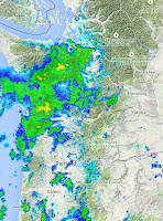
The first group of thunderstorms are now passing through western Washington and more are coming tonight.  The left panel below shows the 11 AM radar, the heaviest showers are west of the Sound, with some fairly heavy (yellow colors).   An infrared satellite image shows the area of clouds associated with an upper level trough, with recent lightning shown by the red crosses.


We have warm, humid area over us now, with many dew points at 60F and above....that is why it feels kind of sticky.


The clouds and precipitation is cooling western Washington, but temperatures are surging over the Columbia Basin--some folks are already over 100F.  Expect many temps above 105F, some reaching 110F


These showers are just the first line, more will come later...here is the 24 hr precipitation ending 5 AM Monday.  Not used to seeing precipitation around here!  But with the rain will come lightning and the potential for new fire starts.  

 The next 24 hr?  More thunderstorms, particularly over the north Cascades and southern BC.
Serious fire threat.


June 27, 2015

Heat and Thunder

The signs in the sky are subtle, but if you can read the clouds they suggest instability in the atmosphere above.   Here is the latest (Sat, 9 AM) image from the wonderful Space Needle cam. You see the puffy clouds at mid-levels?  They are mid-level (10,000-20,000 ft) cumulus clouds that result from instability (convection) in that layer.  Some are even precipitating ice crystals.


A lot has happened during the past day and a lot more will happen during the next 48h.  Heat records will be broken, wildfires will start, and the impact of a very warm Pacific will be felt.   Interesting but serious weather.

The last day brought very warm weather to our region, particularly east of the Cascade crest and in the Willamette Valley.     Here the high temps yesterday over eastern Washington.  Much (most) of the Columbia Basin went above 100F and a few locations exceeded 105F.


A number of daily high temperature records were broken: 
It will be warmer today.

The Willamette Valley was torrid yesterday.  Here are the highs.  Many locations were in the upper 90s and several got to 100F!  I don't believe the 109F, by the way.


Eugene tied their all time record high (98F). The fact more locations did not break any records shows you how warm the Willamette Valley, somewhat isolated from Pacific influences, can be.   But what what was really remarkable about the Willamette Valley temps were the low temperatures, with several locations breaking record JUNE (monthly) records for high minimum temperatures (didn't cool off at night).  Here are the official numbers from the National Weather Service.  Impressive.


Puget Sound maximum temps?  A walk in the park in comparison, but still well above normal.  Mid to upper 80s away from water, 60s near the water.  Thank god for our cool water, something Portland does not enjoy.  The Seattle Office tied its daily record...no big deal.


But there was something remarkable about the temperatures even in Puget Sound.  We got quite warm WITHOUT OFFSHORE FLOW.   Normally, our big warm ups require offshore flow to push out the marine influence, but not this time.   I suspect the reason is that the eastern Pacific is so warm that it is allowing such warmth even when the low-level flow is weakly onshore.

Yesterday, southerly flow developed aloft and moist, unstable air starting pushing aloft into the Northwest.  In fact, there were a number of thunderstorms in south/central Oregon--here are the lightning strikes on Friday:
You can see the moisture streaming northward in a recent infrared satellite image:

The latest UW WRF model high-resolution forecast for 5 PM today (which should be near the high) shows eastern Washington getting very warm, with highs getting up to 104-108F in the warmest places.  Portland is around 100F and the Puget Sound area in the mid to upper 80s.


The latest visible imagery shows instability showers over Oregon.   Expect scattered thunderstorms over Oregon and the southern WA Cascades today.

But tomorrow and Monday will be the really interesting days.   A series of upper level troughs will move through, bringing showers and thunderstorms, particularly later on Sunday and Monday AM.  Temperatures will drop back by 5-10F on Monday and Tuesday, but temperatures may spike over eastern Washington from Richland to Spokane on that day.  

The Weather Channel is going for 107F in Spokane on Sunday.  Here is the 5 PM forecast from the UWWRF system on Sunday.  WHITE HOT over eastern WA with warm easterly flow.   Off the scale. Amazing.  There will be records.  And several locations will get above 110F.

And precipitation?  As the upper trough moves through and cooler air moves eastward late on Sunday, there will be plenty of thunderstorms.  Here is 24h precipitation ending 5 AM Monday.  Lots of rain.  And with that rain there will thunderstorms.

Needless to say, with lightning coming after the furnace-like temperatures of the past few days, the fire risk will be extreme.  Governor Inslee has called a statewide burn ban, which is wise.  Yesterday, he went further, calling for folks to forgo fireworks this year.  Another good idea.   Firefighters will have enough in dealing with natural lightning fires....they don't need human-caused fires on top of that.   All fireworks sales should be banned.  Particularly considering the forecasts.

And now the really serious news.   After a few days of moderating temperatures (still well above normal), the forecast models are suggesting a huge ridge of high pressure will develop next week, one that will produce MUCH HIGHER TEMPERATURES west of the Cascade crest.   Mid to upper 90s in Seattle are possible.  Some western WA locations will get to 100F.   

This is serious folks.   

June 25, 2015

June Without Gloom

One of the unfortunate aspects of Northwest weather is that west of the Cascade crest, June is often a cloudy, gray month.   Generally not much precipitation, but many days of low clouds.  June Gloom. Here is a sample of the typical murk.  Lots of stratocumulus, our signature June Gloom cloud.


 But as shown by a picture from the Space Needle this AM, this June has been a very different animal, one of sun and warmth.   July or August weather in June.  A climate as close to perfect as one can imagine.


But you come to this blog for hard numbera, so let me give them to you!  Here is the average number of cloudy days for each month at several Northwest cities.  A cloudy day is defined as having 80% or more coverage of the sky.  This data is from the Western Region Climate Center.

In June, Seattle Tacoma Airport typically has 17 cloudy days, with most of the remainder being partly cloudy.  Quillayute, on the coast generally has 20.   This is why vampires like Forks and other NW coastal locations.

But what about this year so far?

From official National Weather Service observations, Seattle Tacoma Airport only has had 4 cloudy days so far and from the forecasts it is clear that cloudy days will be hard to find the rest of the month.   The bottom line:   June 2015 will only have roughly ONE QUARTER OF THE NORMAL NUMBER OF CLOUDY DAYS.   4 or 5 cloudy days compared to 17.

But are you REALLY prepared to be impressed?


Quillayute Airport on the NW WA coast typically has 20 cloudy days.   This year?  ONLY 3.  You read this right.  Only three cloudy days on the normally stratus-bound Washington Coast.  You can imagine the impact on local vampires.

Want more.  Yakima typically has 10 cloudy days per month in June.   How many have they had so far?  ZERO.

An amazing month.  Probably the sunniest month in Northwest history.

The reason for all this sun?  The upper-level circulation pattern has been very anomalous the past 30 days, with higher pressure over the eastern Pacific.  Here are the upper level (500 hPa, around 18,000 feet height anomalies) for the past month.   Much higher than normal heights over the eastern Pacific (yellow colors) are evident, with some these higher heights extending over our region.  And the temperature of the Pacific Ocean is much warmer than normal...that works against low clouds as well.

We are about to experience a major warm up, with temperatures rising into the mid-80s to near 90F in western Washington, and highs reaching up 105F east of the Cascade crest.   Lots of sun.  But there will be thunderstorms and the risk of lightning-caused fires.


June 23, 2015

The Wildfire Risk is Rising: How Bad Will it Be?

With warmer than normal temperatures and lack of rain, the land surface and vegetation of our region are drying rapidly.  As a result, the risk of wildfires is rising:  but how bad will it be?

In May a few media outlets were hawking an early and severe wildfire season here in the Northwest, due to low snowpack and low river levels., neither of which have a large impact on wildfires in our region.  Well, we are now at the start of the traditional wildfire season and the reality is that there have been LESS fires and LESS acreage burned than normal in our region.  As I write this, there is one moderate-size fire burning in Washington State (600 acre fire in the Olympics), and the fires in the western U.S. have burned less area and were fewer in number than normal (for proof of this check out this website by the National Interagency Fire Center).


Why less fires than usual?   First, precipitation was only a bit below normal during the past winter/spring.   There is no precipitation drought, but a snow drought, with precipitation falling as rain rather than snow in the mountains.  Thus, eastern Washington started the warm season with near normal soil moisture and normally moist vegetation.

Second, May was unusually wet in parts of eastern Washington and Oregon, keeping the surfaces moist, even though temperatures were above normal.

Third, there has been a dearth of lightning the past month.  This is VERY important because most fires are caused by lightning around here.

But the situation is changing rapidly now and becoming more threatening...the details of which I will describe below

Before we look ahead, it is useful to consider the fire climatology in our region (see below). Lightning fires are dominant over human caused.  Lightning can produce the big surges of fires that can overwhelm fire-fighting resources.   You see the one large spike in human-caused fires?   That is July 4th!  Peak wildfire season is in August.


So lightning is a critical element in controlling the frequency of wildfires.   Thus, you can have hot, dry years that produce few major fires if there isn't much lightning.

To get a major wildfire season you need the surface to be dry, and particularly for vegetation (dead or alive) to be dry and ready to burn.   You dry the surface with a combination of lack of precipitation and warm temperatures/sunshine.   Why warm temperatures and sun?  Because they cause water to evaporate from the surface.

Around here summers are generally dry, except for occasional thunderstorms, which are generally found over and east of the Cascade crest.  So temperature is the key element in drying things out.

We thus come to the first problem:  temperatures have been MUCH warmer than normal during the past month.  To show this, here is the departure from normal of maximum temperatures during the last 30 days. Wow.   Six to ten degrees above normal in much of eastern Oregon an Washington, as well as western Oregon.

This warmth, plus precipitation at or slightly below normal (which is NOT much even during normal years) has caused the surface to dry.   As a result, various soil moisture indices have indicated rapid declines of soil moisture.  For example, the popular Palmer Drought Severity Index (PDSI) shows moderate to severe drought conditions in the upper soil layers over eastern Washington and California.
The U.S. Forest Service reports the estimated moisture content of various types of "fuels".   Here is the estimates of moisture content of the bigger branches and debris (1000-hr fuels).  Low moisture content east of the Cascade crest and northern CA.

So the surface conditions are drier than normal, with the Forest Service folks estimated we are about 2-3 weeks ahead of normal (early to mid July conditions).   Unusual amounts of grass over grew in eastern Washington in May due to the wet conditions that month.  That grass has now dried out and has become a fire threat.   That is why there were a series of fast burning grass fires in eastern Washington during their warm spell last week.   They were put out quickly and did little damage...but they are a warning.

So lets look into the future using the state-of-the-art prediction tools at our disposal.  First, there is a threatening situation during the next week.   Over the weekend, temperatures are going to warm rapidly as a huge ridge of high pressure builds over the region.  Here is the latest forecasts by weather.com for Wenatchee.  For Friday through Wednesday, the highs will be above 105.  Not good. The surface will be toasty dry.


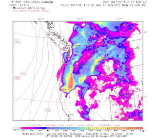
What about lightning?    The latest UW WRF MODEL forecast suggests that starting this weekend the potential for thunderstorms will increase dramatically.   To show this, here are forecasts of something call CAPE (Convective Available Potential Energy)....a measure of the amount of instability in the atmosphere.. for several times starting Friday afternoon.  Instability is needed for thunderstorms.  Substantial numbers of thunderstorms are possible from Friday through Tuesday.

Friday afternoon, lighting could strike the Oregon Cascades and northern CA.


 More on Saturday afternoon, with the risk spreading into eastern WA
 Monday evening....a regional threat

The bottom line is that with very dry conditions in place,  multiple lightning-caused fires are quite possible.  Fire folks need to get ready.

But what about the rest of the summer?   Our seasonal forecast models (like the NOAA CFSv2) can give us some insights.  The temperature forecast for July though September is for much warmer than normal conditions  from northern CA into British Columbia (see below)   This implies drying conditions.  Not good.
Precipitation?   Wetter than normal over the Rockies, with moisture  extending into eastern Oregon (see below). No precipitation signal over eastern WA.  This precipitation will be mainly for thunderstorms, which means lots of lightning over the Rockies, Sierra, and southern Cascades. 

 Where it has been very wet (the Rockies), the fire risk might be reduced by the moisture.  But the places on the western periphery (like the southern Oregon and northern CA Cascades) might be hit by a lot of lightning--and it will be dry there.   And these thunderstorms might drift into eastern Washington.   Substantial threat.
The predicted soil moisture from this model (again for July-Sept) is below normal over the Pacific Northwest. A bad omen.
Based on the above (and other) seasonal forecasts, there appears to be a particularly large wildfire risk this summer, particularly over northern CA and Oregon.    The risk is also high over Washington State.    Dry conditions will exist...the big question is lightning.  The amount of lightning will control the outcome.   Using our high-resolution forecasts, government officials can get a pretty good idea of fire risk days ahead of time regarding lightning and get resources ready to deal with fires quickly.

It is important to note that lightning caused fires are a natural part of the ecology of the region, NECESSARY for the  life cycle of several of our local plant species.   And the extreme warmth this year is probably the result of natural variability--not human-caused global warming.  The real problem is that our civilization has injected population into a natural fire-prone environment and thus some folks are at risk, forcing us to intervene to stop fires in many locations.


Washington State now has a statewide burn ban in effect---a very good idea.  Considering the risk, perhaps they should go further, such as a total fireworks ban, including the sales of all fireworks.  The burn ban does not extend to Federal lands--is that possible?  This would be a good idea, as would clearing brush/grass around structures in fire-endangered areas.

We are dealing with the conditions of 2070 this summer and it will be necessary to use more extensive methods than normal to reduce human-caused fires.   Control of lightning is in other hands.

A Near Perfect Forecast of Yesterday's Event. The Next Windstorm Comes into View

 The next time someone makes a weatherperson joke, remember the nearly perfect forecast for yesterday's wind event over Washington. No l...