December 31, 2021

New Podcast: The Weekend Weather and the Colorado Wildfire

 Today is sunny, but cool, with temperatures in the teens across eastern Washington and in the lower to mid-30s in the west.  Viewed from the space, the state is mostly covered in snow (see below).


My podcast this week (which you can listen to with the link below or through your favorite podcast server) describes a warming trend over the weekend and a generally dry Saturday.

A strong Pacific front approaches on Sunday, with the certainty for lots of snow in the mountains and the potential for more lowland snow on Monday morning into Tuesday.   But lots of uncertainty remains regarding the lowland snow...thus I will need a blog on Sunday to provide a more confident update.

I hope all of you have a good new year.  Has to be better than what we have been through this year.....

You can listen to the podcast below or through your favorite podcast server.


Some major podcast servers:

 HTML tutorial HTML tutorial
Like the podcast? Support on Patreon 


December 30, 2021

A New Weather Concern: The Slush Freeze

 The event last night played out similar to predicted.    For most locations in western Washington, a few inches of wet snow fell and temperatures rose just above freezing.

We have had a remarkably cold period in many ways.   It was the first time since 1998 that Seattle remained below freezing for three days in a row.  Many locations fell below daily low-temperature records.  And Vancouver, Canada at 4.5F had their coldest temperature in 50 years.

The winds and temperatures coming out of the Fraser River valley during this event were historic.

But something interesting (and threatening) could happen tonight and Friday night....a slush freeze...as cold temperatures temporarily return to the region.

Washington DOT and Seattle DOT need to be aware of it.

Good in a cup.  Not so good on our streets.
Courtesy of Frankielion

A Tale of Two Types of Streets

Seattle and most other towns have two types of streets:  major roadways in which plowing, sanding, and salting have taken place and the roads are drivable, and the back streets (often with substantial grades) that are snow/ice-covered and nearly impassable.   This SDOT picture this morning shows the situation well.    I can't drive into or out of my home.  


The Slush Freeze Problem

We started with icy/snowy back streets.  Then we added a few inches of wet snow last night, and temperatures are climbing just above freezing throughout the area.  There is even going to be some sunshine today to melt things even more.

In most weather situations, we would warm up and everything would melt out.

But not this year.    Consider the forecast temperatures from the National Weather Service's National Blend of Models, a calibrated statistical combination of a number of forecast models (see below).  Temperates dropping into the lower 20s the next few nights.


And the National Weather Service GFS model is doing the same thing and even colder, Friday and Saturday morning before we finally pull out of the icebox on Sunday.

Temperatures predicted by the NWS GFS model at Seattle, time increases to the right.  The average of many forecasts indicted by the black line.

My concern is that all of the slush is going to freeze tonight.  And then as temperatures warm near freezing Friday and Saturday afternoons, a super-slick situation will develop.  Nothing is more slippery than ice just above freezing.

Clear the Slush

Today is the day to clear the slush. 

SDOT and WA DOT should make efforts to move aggressively on the side streets, once the main roads are clear (and they pretty much are now).  Get rid of slush with plows while it is soft and melting.

You should do the same for your house or apartment.

More Snow Next Week?

Some models are going for more snow next week.  Considering the European Center ensemble of many forecasts (shown below).  In the top panel, there are 51 forecasts (y-axis) and time increases to the right.  The shading shows snow accumulation (darker blue and purple indicate more snow).  The bottom panel shows the average of all the models and the blue line indicates the value of a high-resolution European Center forecast.  

Increasing chances of snow on Monday, and the US GFS model is similar.   At this point, I would take it all with a grain of salt, but it bears watching.


For many reasons, our region is one of the most vulnerable to roadway icing.  Perhaps as a new mayor comes into office in Seattle, some discussion of increasing snow removal and road prep capabilities will be discussed.  The economic costs of an ice-impeded city and region are huge and more resources would be an excellent investment both economically and in saving lives.


December 29, 2021

A Difficult Snow Forecast--As True of Most Western Washington Snow Events

 Forecasting snow in western Washington is very difficult, even with modern prediction tools.

Before high-resolution models and satellite observations over the Pacific, it was nearly impossible to accurately predict local snow events and major local snowstorms occurred with little warning (for example, December 18, 1990).   

Picture courtesy of Oran Viriyincy

Consider:

1.  There is roughly a one to ten ratio between precipitation totals (amount of water falling from the sky) and snow totals, so a small error in precipitation amounts results in huge snowfall errors.  Making a 0.10 error in precipitation provides a 1-inch error in snowfall.

2. Temperatures over the western lowlands are often marginal for snow.  Right on the edge.  So small temperature errors can produce huge changes in snowfall.   Same with small changes in elevation or distance from the warm water.  

3.   There are huge local differences in precipitation because of our local terrain, such as rainshadows, convergence zones, gaps winds, and more.  Plus, our complex land-water contrasts.

It ain't Kansas around here.  And forecasting snow in Kansas is a piece of cake compared to our challenges.

The snow forecast tomorrow has all of these elements, with the snow mainly between midnight and 10 AM,

Here is the snowfall total for the period through 2PM Thursday.  Healthy totals in the mountains.  Little on the coast and the Strait where temperatures will be too warm. Less in the lee of the Olympics mainly because of snow shadowing in the lee of the Olympics.   And temperatures will be on the edge for the southern Sound (yes--Puget Sound will see temperatures rise above freezing tomorrow late morning and afternoon)


Here is a close-up view of Puget Sound land.  Greens are two inches or less.  Not a big snowstorm for the lowlands--and keep in mind that the snowfall over a period will be LESS than increases in snow depth, something I talked about in previous blogs.


Is there uncertainty in the forecast? 

Of course!  Slight changes in wind direction or temperatures can greatly change snow amounts locally.   The way we attempt to quantify such uncertainty is through ensembles...many slightly different forecasts.  And the UW has one of the best, highest resolution ensemble systems in the country.  

Here are the ensemble snowfall forecasts for SeaTac.  A range from .3 to 1.7 inches of snowfall, with a mean of roughly  0.8 inches.  You won't write an epic novel on this event.  The National Weather Service is going for about an inch.


We are still on track to break out of the freezer on Saturday--with the ice and snow melting over the weekend.

December 28, 2021

A Snow-Shadow Snow Event

 You have all heard of a rainshadow.  

Air approaching a barrier rises on the windward side, producing lots of precipitation, while air sinks on the lee side, causing drying and a lack of rain (see graphic).


On Thursday, we are going to have a profound snow-shadow situation for large portions of the western Washington lowlands, particularly around Puget Sound, and snow lovers like myself are going to be disappointed.

Below is the latest super-high resolution UW snowfall forecasts for the 24-h ending 4 AM Friday morning.  Light green is less than an inch, while purples and darker colors indicate more than 6 inches.

Plenty of snow on the windward (western) sides of the Olympics and Cascades.  Bellingham is going to be snowed in!  But little around Puget Sound and virtually nothing from north Seattle to north Kitsap.  No snow near Yakima on the eastern side of the Cascades.


Looking at snowfall for the entire region for the same period (below), you can see little snow on the lower eastern slopes of the Cascades and then a HUGE snow dump on the Blue Mountains of southeast Washington.  The dryland wheat farmers will be smiling.


So why so little snow around Puget Sound? The problem will not be the temperature--it will be cold enough to snow. The problem will be a lack of precipitation.

And that deficiency is due to the orientation of the winds in the lower atmosphere, which will be from the northwest, resulting in downward flow on the lee side of the Olympics.

To show this, here are the heights (like pressure) and winds at the 850 hPa pressure level...roughly 5000 ft at 1 PM Thursday.  The winds are from the northwest over the Olympics, resulting in a snowshadow over Puget Sound.  Bellingham and vicinity are not in the lee of the Olympics (or the mountains of Vancouver Island) for this direction, so they will get plenty of snow.  There is a small chance that portions of Seattle might get some light convergence zone snow....but that is uncertain at this point.


Well, at least there will be plenty of snow in the Cascades for recreation and water supply--all good.

Temperatures will moderate over the weekend and snowy roads in the lowlands will become a memory.  Life will return to normal--except for the COVID situation.


December 27, 2021

Why Does Western Washington Have Some of the Worst Roadway Icing in the Country? And the Next Snowstorm in Sight

 Western Washington can brag about world-class coffee and leading corporations, but did you know we also have some of the worst road icing conditions in the nation when we get some snow?

Icing so bad that mayors can lose their jobs when they forget this meteorological fact?

Icing that can cripple parts of Seattle, killing and injuring both drivers and pedestrians?

Roosevelt and NE 75th Around 1 PM. ICE!

It happened again last night and today.  Let me tell you why.

Western Washington has a mild winter climate and our soils and roads cool down in autumn, of course, but remain well above freezing during the winter.

Then we get a snow event, with several inches falling on the roadways.  This snow starts to melt into a slush layer.

Next, much colder air comes in, as the low center and upper trough that produced the snow moves out.  The air temperatures become cold enough that the slush layer begins to freeze...and if cold enough (like yesterday today), it freezes solid to the roadway surface (and almost impossible to remove at this point).

The only way to stop this is to pretreat all roadways with a deicer (such as salt or potassium chloride) BEFORE the show falls and to remove snow after it falls, but before it freezes.   Judging from driving around Seattle today, not enough of both were done.  Many of the city's major roadways are not in good shape.

Another interesting aspect of this event has been the terrific steam fog produced over the Sound and other local water bodies.   When very cold air passes over relatively warm water, you can get tendrils of steam fog.

To illustrate, take a look at a video shot from the north side of the Kitsap Peninsula by Greg Johnson of Skunk Bay Weather.


The warm water supplies moisture that condenses in the cold air moving above.   Generally, you need at least 20F differences between air and water temperatures to get good steam fog.  With the Sound at around 50F and 20F air moving in, we had the necessary conditions.  Strong winds help the mixing and fog formation.  We had that as well.

The temperatures last night were exceptionally cold, with some areas around NW Washington dropping to UNDER 5F (see the minimum temps below).  

Seattle dropped to 17F. Some Puget Sound suburbs plummeted to nearly 10F.  Many daily minimum records were broken and this event as a whole is the coldest period in our region since 2010.


Thursday Snow?

Finally, there is the upcoming snow event on Thursday.  Both the UW and European Center models are going for several inches.

Here is the European Center 24-h snowfall ending 4 PM Thursday.  4-5 inches over Seattle.


The UW model for the same period is similar with some interesting differences (see below), with more snow on the coast and Seattle's snow reduced by rainshadowing.  As we get closer to the event, the forecast will sharpen up.


December 26, 2021

The Arctic Front Arrives Bringing Lowland Snow and Dangerous Windchill

 Update:  Here are the latest storm totals from the National Weather Service.  Heavy snow near Port Angeles (10-15 inches) and 1.5 to 5 inches around Puget Sound.


Here is an expanded version around Seattle.  Perhaps an average around 3-3.5 inches.

_____________________

As predicted, the cold air pushed into western Washington, with the arctic front on the leading edge, with highly variable snow depths reported at 7 AM this morning (see Cocorahs snow map below). 


Cold air entered Bellingham yesterday leading to lots of snow (4-15 inches reported), and as the cold  air pushed southwestward later yesterday, the northern Olympic Peninsula area areas (e.g., Sequim to Port Angeles) got hit hard, with up to around a foot of snow.

Over Puget Sound, most of the snow action was with the arctic front this morning, with 3-5 inches being reported.  The radar image at 7:37 AM this morning clearly showed the intense arctic front snowband (yellow colors) pushing southward.  The high-resolution models got this feature essentially correct.


The current observations show tremendous temperature and wind variability across the region (see surface map at 10 AM, click on I'm age to expand).  The leading edge of the arctic front is now (11 AM) around Olympia (blue line), with northerly flow behind it and southerly flow in front of it.  The convergence of air into this feature causes upward motion and precipitation.


In a stunning visible satellite image at 11 AM, you can see the front edge of the arctic front approach Hoquim (see below).


At Bellingham, the temperature this morning was 10F, with winds gusting to 56 mph.  Severe windchill for this region:  equivalent to -18F!  Temperatures below 10F are also moving through Omak and the Okanagan Valley into eastern Washington.

There will be some light snow today, producing perhaps another inch and then it will clear out tonight, allowing cooling (infrared radiation to space).  Temperatures should drop into the upper teens from Puget Sound northward, with lower temperatures over Northwest Washington.  Even colder over eastern Washington.    This is the cold that has been advertised for the last several days.

Seattle DOT and Washington DOT need to remove as much snow as they can from the roadways.  Any snow will turn to ice during the next 24h, as heat from the roadways initially creates a melted layer near the surface that will subsequently freeze.  And chemical treatment as well.   

Icy roadways are the greatest weather killer of Washingtonians.....WAY more than heat waves, something you may not hear about in the media.  The truth is that cold weather is a far greater killer in our region than heat waves. 

The Potential Thursday Storm

With cold air entrained over the region, we will be very vulnerable to potential snow.  On Thursday morning, a low center and front will be approaching our region, with cold air in place (blue colors in figure below).  There is still some uncertainty with this feature, so I need to be careful in talking about it.


The current UW model run puts down substantial snow, but there is a large snow gradient across the Sound (the result of Olympic rainshadowing and temperatures on the edge).  Around 2 inches over Seattle.


The European Center model is going for more, but has the same general idea.


Anyway, we will keep our eyes on this.
_______________________________________________

PS:  there are a lot of amateur enthusiasts that are looking at the raw model output.  Please keep in mind the difference between snowfall and snow depth.   When temperatures are marginal (such as on Dec. 25th), the snowfall tends to be MUCH higher than the resulting snow depth.   After the temperatures cool off (like today after midnight in Puget Sound, when temperatures are colder and snow ratios are larger (snow depth to depth of liquid water), snowfall and additions to snow depth are much closer.


December 25, 2021

Weather Showtime is Approaching--- And a More Threatening Snow Situation Reveals Itself

Some light snow has fallen around Bellingham and environs in the Fraser River outflow (see below), and modest snow has also fallen to the southeast of the Olympics over portions of the Kitsap Peninsula.  Snow has whitened the region above roughly 1000ft, and heavy snow continues to fall in the mountains.

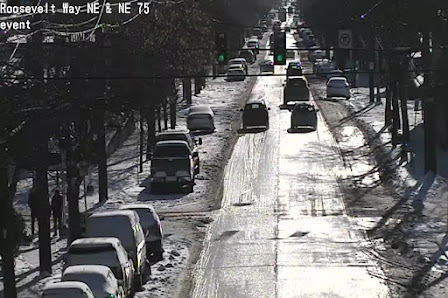
I5 north of Bellingham

But the real action is ahead, both in cold and snow, and it appears that we have a shot of more extensive lowland snow on Thursday.

The Cold

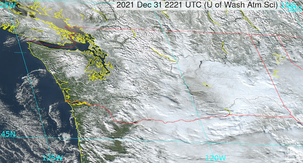
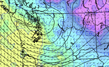
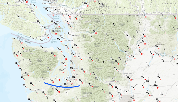
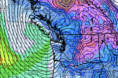
A modified Arctic front will move through Puget Sound around midnight.  Temperatures will plummet with its passage, which will also be accompanied by a dramatic shift in wind direction to the north.   Cold air has already started to pour through the Fraser River gap into Northwest Washington, with temperatures dropping into the mid to low 30s, borne by strong northeasterly winds (see map for 11 AM, red numbers are gusts in mph).


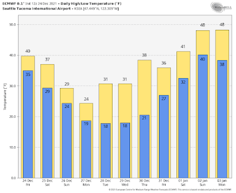
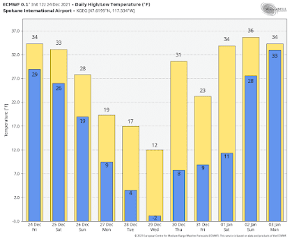
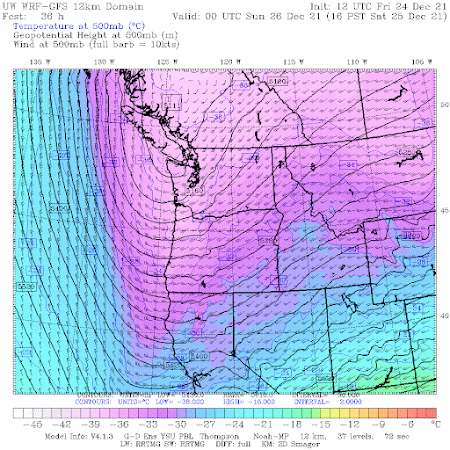
The forecasts are now consistent and reliable.... western Washington will experience temperatures dropping to the lower to mid-teens, while eastern Washington will get the full arctic treatment, with highs in the single digits and lows below zero (see European Center temperature forecasts below)


A number of eastern Washington locations will experience more than 100F swings between the highs last June and the lows this week.  A few westside locations may as well--which will be unprecedented in the historical record.

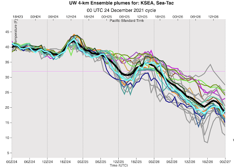
Many locations around the Northwest will experience daily (not all-time) low-temperature records.  And if you want to be impressed, consider the temperature at around 800 meters above the surface at Quillayute on the Washington NW coast (925hPa pressure level).    It will be the second coldest time in the 73-year record there (see plot below, the red star is the forecast temperatures at that level, the blue line shows the record low temperatures for that date).


Snow

Like politics, snow is essentially local in nature.   Today, snow is all about temperature, with the atmosphere being generally a bit too warm for snow near sea level.

There is light snow over NW Washington because of the cold air coming out of the Fraser River Valley.  

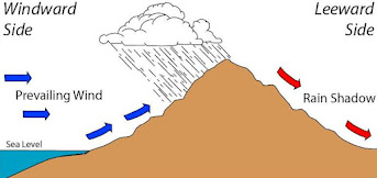
This evening, as strong northeasterly flow pushes out of the Fraser River Valley, it will be forced upwards on the NE side of the Olympics, producing localized heavy snow.  The rainshadow folks around Sequim and Port Townsend will experience precipitation like the rest of us.....you have to smirk about that.

3-h snowfall and low-level winds valid at 7 PM tonight

Why is the cold air pouring out of the Fraser River valley and points north?

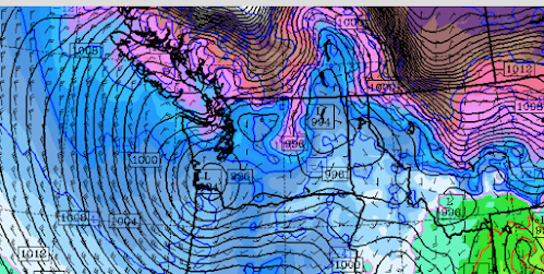
Because a low-pressure system will be moving eastward across southwest Washington (see surface map at 4 AM tomorrow morning).  With intense cold, high pressure over BC, and lower pressure near the entrance to the Columbia River, cold air is being pushed to the south.

Sea level pressure (solid lines, and 800-meter temperatures, colors)--brown and purple are the coldest temperatures.

Overnight the leading edge of the cold air, the arctic front, will move though--not only supplying cold air but providing uplift that produces precipitation--snow.  That will be aided by an upper-level trough moving through.

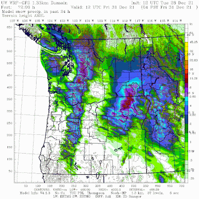
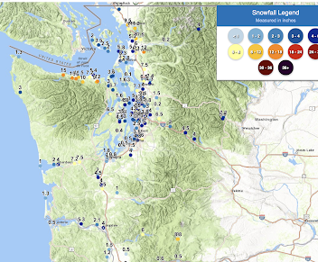
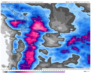
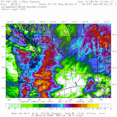
By tomorrow morning, most of western Washington will have some light snow.....generally no more than an inch or two.  The 24h snowfall ending 4 PM Sunday is shown below.  Greens are less than 2 inches, with blues (2-4 inches) generally east of Puget Sound.


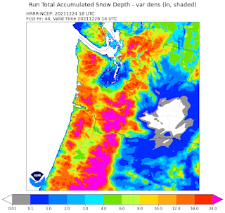
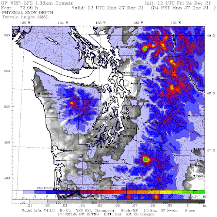
But this is snowfall....which includes snow that will melt.  The amount predicted to be on the ground at 10 AM tomorrow is not so impressive (see below).  Colors start at 3.7 inches. Grays indicate lighter snow amounts (in meters).


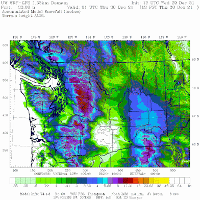
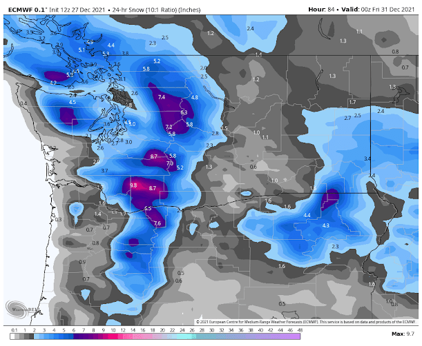
Enough snow to whiten the region a bit.  And snow is a cooling machine...reflecting solar radiation to space and emitting infrared radiation from the surface.

Finally, the big lowland snow threat in the future.  On Thursday, cold air will be in place and a Pacific front will approach, resulting in precipitation (snow).  The 24-h snowfall ending 4 AM Friday is much more significant for central Puget Sound.   More on this as we get closer.


December 24, 2021

The Cold/Snow Forecast is Now Much Clearer

I will have a Snow Update at Noon (Dec. 25th)

_____________________________________

As we get closer to an event, very powerful tools become available to meteorologists:  high-resolution model predictions, high-resolution ensembles of many forecasts, the NOAA/NWS HRRR model, to name only a few.

And forecast skill obviously improves as we get closer to the event.  

So based on all this technology, and decades of experience in predicting Northwest snow, let me provide you with the latest update.

NOAA HRRR Model Snow Depth Predictined for 6 AM Saturday

First, temperature.  

The temperatures are too warm for snow over the lowlands today, with the current freezing level approximately 2300 ft.  The snow level (the level at which all snow is melted) is about 1000 ft lower (1300 ft).

Near-surface temperatures will remain above freezing throughout the night and Saturday morning/early afternoon.   Temperatures will be a bit colder around Bellingham as cold Fraser River air starts to move in.

 But around 4 PM tomorrow (Dec. 25th), all hell will break loose as Arctic air pushes energetically through the Fraser River Valley into NW Washington.  Temperatures will rapidly fall below freezing in western Washington, with gusty winds from the north. Arctic air will also push south into eastern Washington.

Trust me...you will know this is happening....the equivalent to being hit by a meteorological sledgehammer.

Here are the daily high/low predictions from the European Center model for Seattle.  By Monday, a high of 24 and a low of 19F, with the lows cooling a bit the next few days, followed by warming at the end of the month.

Spokane (and eastern WA) will be much cooler, with highs in the teens, and lows falling below zero.


The UW high-resolution ensemble system, with the WRF model run many times with small differences in its starting point and physics, is a powerful tool for looking at uncertainty.  Below are the forecast temperatures at SeaTac, time is on the x-axis and 00Z/26 is tomorrow at 4PM.  

You can see the big plunge around 4 PM. Some uncertainty, but all runs show rapidly falling temperatures (the black line is the average of all the runs).    A drop to the upper teens.


An even higher resolution forecast run is taking the temperatures 5-10 F lower still in some western Washington locations away from the water.  Cold spots in the west will probably drop to 10-15F.  We will probably experience the coldest temperatures since 2010 when it got to 14F.

Snow

No lowland snow today of any importance (if you are above 500 ft you might see some errant snowflakes).  The same will be true overnight, except for some very, very isolated heavy snow showers.

Most will wake up to experience a snowless Christmas morning. You might see some snowflakes mixed in the precipitation and perhaps some very wet snow that rapidly melts.

But then, as the cold air moves in during the late afternoon, all precipitation will turn to snow.

The trouble is that there won't be much precipitation.

The snowfall map through 4 AM Sunday, shows as much as 4 inches from Everett southward for western WA. 


But the predicted snow DEPTH on Monday morning at 4 AM, after another 24 h of scattered showers, is unimpressive.  Yes, the ground will be white around Puget Sound, but generally less than .06 meters (about 2.5 inches).  Not big snowfall that kids (both young and old look for).


The origin of the lack of precipitation is a subtle one.  The upper-level trough associated with this event is directed too far southward, moving the greatest upward motion (which produces precipitation) to our south (see the upper level--500 hPa pressure level--for 4 PM Saturday below).


December 23, 2021

Most Will Have to Dream of a White Christmas

Detailed update this afternoon....I will have the forecasts from the more powerful high-resolution forecast models by then....

___________________________

I have some disappointing news for many living over the western Washington lowlands.

Saturday, December will not bring extensive lowland snow on the ground.

On the other hand, many of you will enjoy seeing snowflakes falling out of the sky, which coupled with a rendition of Irving Berlin's classic music and some hot chocolate, might be enough.

Not this year.  Picture by Steve Voghut

Large amounts of snow are expected in the mountains, so snow recreation will be excellent and close.

Snow 101

The temperatures during the next few days will be marginal for snow near sea level, which is often the case in our region.

In addition, the ground temperatures are relatively warm, as illustrated by the current soil temperatures from the WSU AgWeather network, which are in the low 40s in the west and mid to upper 30s over the Columbia Basin (see below).


The distinction between snowfall (amount of snow falling out of the sky) and snow depth is an important one, with snow depth often being MUCH less than snowfall.   

First, in marginal situations, the snow is already melting before it hits the ground, with above-freezing air temperatures within the lowest few thousand feet.  This will be the case during the next few days.

Second, light to moderate snowfall is melted by the warm surface.  This will happen as well.

Another issue is model resolution.  The waters of Puget Sound and the Georgia and Juan de Fuca straits are relatively warm (around 50F).  Furthermore, these water bodies are relatively narrow...so narrow that many models do not have the resolution to include their warming properties in the forecasts.

In addition, the lack of resolution in global models, particularly those used in global ensemble forecasts, causes surrounding terrain to "spread out" into the lowlands, producing colder surface temperatures and more snow than is reasonable.  

The Christmas 2021 Situation

The latest UW WRF model forecast is out, with the snowfall accumulation through 4 PM Saturday shown below.  This is a relatively high-resolution model (the distance between the grid points is 4 km).  Lots of snowfall in the mountains (1-2 feet) and light snow over the lowlands (under 1.5 inches) and nearly nothing near the water.

Quite a bit of snow near Spokane but nothing in the Tri-Cities.


But now let me show you the snow accumulation (snow depth) on the ground over western Washington predicted by the same modeling system for the same period. 

Virtually nothing over the lowlands, with the exception around Bellingham and San Juans, where cold Fraser River outflow helps maintain snow accumulation.


Eastern Washington snow depths through 4 PM Saturday are more extensive, with Spokane certainly enjoying a snow-covered landscape. A colder environment, isolated from the warm water of the western side.


The big issue is still the unusual cold that will move into the region on Sunday through Wednesday.  I think the models are having a problem with the event, for reasons I won't get into here, but lows of 5-10F in the western side of the state still appear viable.


Should I Let AI Write My Blogs?

I spend a lot of time thinking about and writing my blogs.   Could AI apps do the work for me?   Could any of you tell the difference? Well,...