Ironically, this period of warm temperatures and sun was preceded by cool temperatures and snow down to around 1000 ft on Monday, with nearly a foot of snow at Snoqualmie and loads of accidents in that pass. The culprit: cold air behind a strong cold front and a Puget Sound convergence zone that extended into the mountains. But that is all behind us now!
Snoqualmie Pass at 6:17 PM on Monday evening hardly looked like a place preparing for a heat wave!
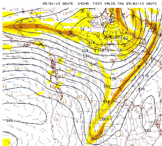
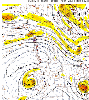
During the next week a major ridge of high pressure will build and hold in place over the eastern Pacific. Let me show you, using the upper level forecasts at 500hPa, about 18,000 ft above the surface.
The forecast for Thursday at 11 AM, shows a ridge, but a weak short-wave disturbance will bring a few clouds and hold back the temps. Decent weather in the 60s.
By Friday at 5 PM, the disturbance is well through and the ridge is building. Sunny and low 70s.
The ridge builds over the weekend over us and a low develops over California--not good for the sun-accustomed folks of southern CA, but a very warm pattern for us due to the easterly flow above the northwest. 80F is NOT out of the question for many of you.
Tuesday morning? The pattern is holding (see below). Believe it or not you will become sick of heat and sun!
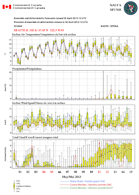
OK, some of you are ready to chide me. You can't trust one model run! What do the ensembles (many forecasts made with slightly different starting points or physics) show? Well, you are right, and below is the output from the North American Ensemble Forecasting System (NAEFS) for Seattle. The top panel show temperatures (C not F!). The line in the middle of the yellow boxes give the median values (half of the simulations are above, half below). The highest and lowest forecasts are shown with the "wiskers" protruding off the boxes. Bottom line: warming, with very little doubt about it during the next five days.
The second panel gives precipitation. VERY dry in nearly all the ensemble members for the next week or so.
And if your heart needed any more warming, here is the latest 8-14 day temperature forecast from the Climate Prediction Center. Probabilities weighted for temperatures to be warmer than normal (and needless to say, no precipitation).
As I have said several times in earlier blogs...this spring is not a repeat of the past two.
Want to help find out the effects of coal trains on the local environment?
Atmospheric Chemistry Professor Dan Jaffe is ready to begin a study on air pollution from trains, especially freight and coal trains, in the Puget Sound region. Several state and local agencies told him that this work needs to be done, but that it is too politically hot for them to fund.
Considering the importance of this work, Dr. Jaffe is going to depend on crowd funding to support this effort. For more information and perhaps to help, please check out this website:
https://www.microryza.com/projects/do-coal-and-diesel-trains-make-for-unhealthy-air


We had snow at 850 feet in Snoqualmie this morning at 7:45 am, sticking on the grass even!
ReplyDeleteThanks for the note about Dr. Jaffe's project and the crowd funding request. What a great idea! I love the idea that this could, in some small part, lessen the political and business influence on academic research.
ReplyDeleteThe NWS 6-10 and 8-14 Day Temp outlooks look incredible if you like warm spring weather(http://www.cpc.ncep.noaa.gov/products/predictions/610day/index.php and http://www.cpc.ncep.noaa.gov/products/predictions/814day/index.php) I just find it puzzling that the 8-14 Day precip forecast seems to be turning toward average rather than staying decisively drier than normal, like the 6-10 Day precip forecast.
ReplyDeleteI remember last May you mentioned an interesting phenomenon where we get a period of warm weather in the middle of May and then it goes back to doom and gloom until Summer decides to show itself. Is this different than that? Thanks!
ReplyDelete