Only local mayors are content.
The first half of the snow season is now over, but should we expect the remainder of the winter to be similar? I can't tell you how many plaintive emails I have gotten about this topic. So let's deal with it here.
First, how bad is it? Let's start with the latest numbers from local ski areas and other sites from the NW Avalanche Center (below). Only high-elevation Paradise (5500 ft) is above 50%, and not by much (54%). Others range from abysmal (Hurricane Ridge and White Pass at less than 20%) to terrible (Timberline, Stevens, and Snoqualmie at around 40%).
Looking at the % of water in snowpack (SWE or snow water equivalent), one notes conditions are poor (less than 50%) in western Washington, Oregon, and the CA Sierra. Things improve over northeast Washington and eastern Oregon, and are at or better than normal over Montana, Wyoming, and Colorado.
The problem, as I have documented in this blog, has been persistent ridging along the West Coast, interrupted by WARM, wet patterns associated with atmospheric rivers (the Pineapple Express).
So what about the future?
Let me begin with the KEY PRINCIPLE:
Never assume that the second half of the Northwest snow season will be like the first.
On many years the pattern has reversed, and a poor first half is followed by a bountiful February and March. Seriously. This often happens.
Our models are good enough that we don't have to speculate about the next week and the news is moderately good: there will be some snow during the next few days,
Here is the snowfall prediction for the 72h ending 4 PM on Sunday. Several feet in the north Cascades and good snow into northeast Washington and southeast BC. Unfortunately the Oregon Cascades do poorly except at the very highest elevations. The reason? the air mass will be very warm on Saturday as a warm front moves through; as a result, the Oregon Cascades will be hit by heavy rain (3-5 inches). Bad for snow.
A little more snow continues in the WA Cascades. the next 24 h (see below), but after that the ridge builds back again and shuts the snow down.
So if you aren't going to or watching the Seahawks game on Sunday, that would be an excellent day to hit the slopes, particularly from Snoqualmie northward. Monday will be decent as well for those who are off that day.
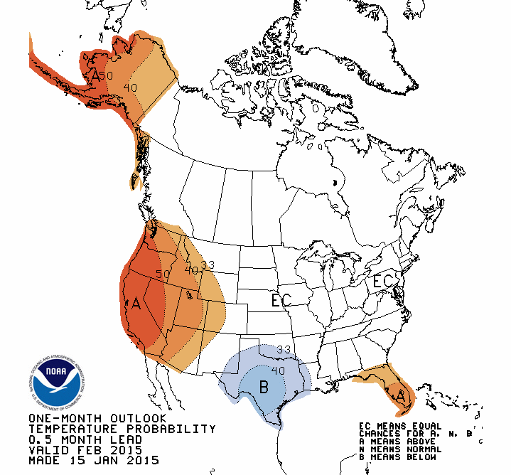
Now the bad news. The NOAA Climate Prediction Center 6-10 day, 8-14 day, 1 month, and 3 month forecasts are all the same and BAD. Warmer than normal and drier than normal. Here is the one-month prediction to illustrate.
However, the accuracy of these forecasts is quite uneven-keep that in mind.
What about the National Weather Service's sophisticated seasonal forecast model, the CFS? You don't want to know. VERY warm (surface temperatures) the next few months. And it is going for ridging (high pressure over the west)--not shown here.
What about the large International Multi-Model Ensemble (IMME), which includes many long-range models? Such a large ensemble should be more skillful. Quite warm for February and March. Ouch.
And there is a lot of agreement among the models, which suggests we should have confidence in this forecast.
The bottom line: the second half of the Northwest snow season does not look good. The ski areas will get by...barely...with a bit of snow here or there. But the snowpack forecast is not favorable and a betting person would wager that the snow depth on April 1 will be below normal.
Ah yes...it looks like light rain during the Seahawks game...which is probably favorable to Seattle.
10 PM Thursday Night It Was Snowing Hard in Snoqualmie Pass

.gif)


Recreation woes in winter may portend recreation woes come summer as well. Without a healthy snowpack to act as Nature's drip-hose, spring rains will partner with the above-average temperatures and our growing season may begin before Easter.
ReplyDeleteIf we have a bountiful "green-up," then have our climatological average or less for summer rainfall to mitigate the die-off and drying of vegetation, then we could be headed for another busy fire season. Down here in the Oregon Department of Forestry, we're still trying to catch our breath from 2 consecutive bad years.
Thanks Cliff!
ReplyDeleteSad for skiing, but my golf game will improve.
Jay
I enjoy the cold weather and snow so very much and as an artist, I anticipate my yearly tradition of creating snow sculptures, particularly of cats (something the neighbors always get such a kick out of). So, discovering that snow may not be in the forecast this season, leaves me feeling very disappointed. I will continue to hope for snow because it is as elusive as the mayfly and has a habit of showing up when no one expects it, kind of along the comedic themes of "Nobody expects the Spanish! inquisition!!" Ever an always, I shall remain hopeful that mother nature presents a wintery opportunity in the near future.
ReplyDeleteI predict that spring flowers and leaves will emerge about 3-4 weeks earlier than normal this season, due to the unusually warm temps.
ReplyDeleteAre there any strong indications regarding temperature and precipitation for April through June, and July through September?
ReplyDeleteAre there tools available that could help community garden managers in the Snoqualmie Valley be better prepared for the growing season ahead especially knowing now that the summer water levels will be low?
As usual Cliff your blog is of great interest and value to us that depend on weather data to serve our communities.