Here is a map showing you today's maximum temperatures (F) over SW Oregon and NW California. Over 100F AT THE COAST at Brookings and at Gold Beach, just to its north. As shown by the sea surface temperature chart below, the water temperature was about 12C (54F) and the air temperatures were not much warmer over the water. Some folks leaving Brookings harbor would go from torrid to chilly in a few minutes. Warm temperatures (100F and more) were found around Medford (a well known heat hole) and as far north as the southern Willamette Valley. But the really nutty heat was over coastal NW California, where a number of locations got over 110--with one hitting 117F!
Let's zoom in a little closer for these two hot coastal locations. First, Brookings. Lots of 101 and 102F readings, with a location up in the hills reaching 108F.
Northwest California? Here it is. The purple colors are above 110F. Some folks' marijuana crops are going to be awfully wilted there. One location had 111 F near the water.
So why these crazy warm temperatures? First, the air over the region is very hot---very near record breaking in the lower atmosphere. I can prove this, by showing you climatological temperature data from the radiosonde (balloon-borne weather instruments) at Medford, Oregon (see below, courtesy of the NOAA/NWS Storm Prediction Center). The black line shows the average temperature for each day at 850 hPa (around 5000 ft) and the red line the extreme highs (daily records) at the 0000 UTC (5 PM) sounding time for this elevation. The grey dot is today. Very close to a daily record. Far above normal.
But the warm air aloft is not enough to give crazy warm coastal temperatures. The cool, dense air would like to move in and displace the warm air over land. You all have heard of sea breezes, driven by the differences of temperature between water and land. For your reference, here is a schematic of the sea breeze.
So why didn't we see a super sea breeze that would have prevented the coast from seeming like the Sahara desert? Something stopped the cool ocean air from pushing in, at least for a while.
The answer is strong lower atmosphere offshore flow driven by larger scale atmospheric circulations, To demonstrate this, here is the vertical sounding (produced by a radiosonde balloon) at Medford, Oregon at 5 AM this morning. I know this is kind of techie....but stay with me. The vertical axis is height (in pressure), with 700 indicating about 10,000 t. Temperature (red line) and dew point (blue line) with height are shown. The winds are shown by the blue barbs. Between 900 hPa (around 3000 ft) and 650 hPa (around 12,000 ft) the wind were easterly (from the east), pushing warm air towards the water.
But wait, there's more! The coast areas of SW Oregon and NW California are very mountainous and thus air moving eastward would descend as it headed to the coast. Sinking air warms by compression, since it is going from lower pressure aloft to higher pressure at low levels. Thus, not only is marine air prevented from moving in, but the air reaching the coast is superheated by descent. No wonder some coastal areas got very warm.
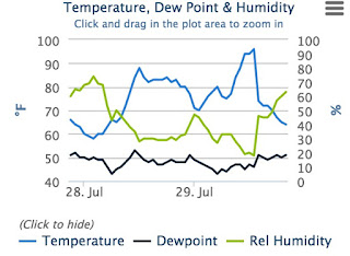
The sea breeze, driven by the huge temperature gradients along the coast, did develop later in the day, resulting in a battle of meteorologically epic proportions occurred at some coastal locations, with huge temperature changes. Here are some samples of the temperature and humidity at Brookings Airport and at Klamath, California.
Brookings Airport
______________________________________________________________________________
Klamath California
Both coastal locations had sudden drops in temperature and rapid rises of dew point during in the afternoon as the sea breeze won the battle. Further inland, the offshore flow remained dominant.
Few areas of the world have such cold water next to such warm land. We live in a land of contrasts. Enjoy!


Seems like the on-shore/off-shore wind battle would result in uplift. Was the air too dry for this to generate convection clouds or storms?
ReplyDeleteGood analysis, Cliff. I believe the fundamental reason that air warms as it moves downhill is just the force of gravity. Like a ball rolling down a hillside, the air molecules gain energy, which translates into heat. And yes, increases the pressure, which is due to the impact of these energetic molecules on the sides of a container.
ReplyDeleteWhy is the water temp so much cooler right on the coast versus a few miles out at the same lattitude?
ReplyDelete