The satellite pictures this morning are simply stunning, made even more impressive by the imagery available from the new NOAA/NWS geostationary weather satellite, GOES 16.
On the left is an image at 6 AM PST using visible light. You can see the tight swirl of clouds that circle into the low center. Beautiful. Cold air is streaming off of the Carolinas and Georgia and rapidly becomes unstable and cloud filled off the coast. (Cold air is going over the warm Gulf Stream; cold air above warm air near the ocean produces a large change of temperature with height, which causes the atmosphere to convect).
The picture to the right is at the same time, but uses the infrared part of the electromagnetic spectrum. Infrared takes the temperature of the clouds and surface, with colder temperatures generally indicating higher clouds. Note the shield of high cirrus-type clouds extending to the northwest and north of the low center. The colors indicate the highest clouds, black is low level stuff, with grays at intermediate altitudes.
A close up of the low center will impress:
The National Weather Service surface analysis at 4 AM PST, shows a strong cyclone with an estimated central pressure of 964 hPa--very strong for the area--with an intense pressure gradient to the south and west of the low center. This is the classic structure of a marine cyclone.
A storm that deepens by 24 hPa or more in 24h is undergoing explosive cyclogenesis and often called a "bomb". Some edgy meteorologists sometimes call the process bombogenesis....but you won't find such loose talk in this blog.
The latest runs of the NWS HRRR model takes the low northeastward up the coast (see forecasts for 8 AM and 1 PM PST below). A huge pressure gradient will pass over eastern Long Island and SE New England: expect gusts over 50 mph there and power outages.
And with cold air streaming off the continent, there will be plenty of snow. The 18-h forecast of the NOAA/NWS HRRR model over an 18-h period starting 1 AM PST this morning shows over a foot from eastern LI into coastal New England. And this doesn't include the whole event.
Finally, this storm was very well forecast, with the threat indicated over a week ago. The NOAA/NWS 78hr GFS model forecast (sea level pressure and precipitation) valid 10 AM PST this morning was very good (see below, courtesy of Colorado State).
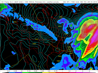
But you want to be really impressed? Here is the 360 hr forecast (15 day!) for 10 PM last night. HUGE storm predicted. A little fast, but amazing none the less.
The forecasts are so good now, the marine traffic avoids the storm. This plot shows the the wind gusts and circulation around the storm at 1 AM PST, with ship locations plotted. Only one errant ship on the SE side of the low...I hope they don't get into trouble. In the old days, ships would get into the centers of big storms and give us reports (if they didn't sink). Few ship observations in storm centers now.
Talking of avoidance....almost no flights across coastal NY and New England!
Numerical weather prediction has come a huge way in the last few decades...and my colleagues at the National Weather Service can be proud of the highly useful products they are providing to the nation.


How does this cyclogenesis compare to some of our larger winter storms here in the PNW?
ReplyDeleteI hear that the 24 hour pressure change is approaching 60 hPa.They're calling it a "superbomb"now.
ReplyDeleteWe'll be lucky if our approaching low off the Oregon coast deepens by 10 hPa by the time it makes landfall tomorrow.
Cliff, can you share what causes the sudden drop in pressure? At least the main variables.
ReplyDeleteI remember the infamous "reverse cyclone" that hit NE a long time ago, the ocean actually backed up and overflowed from harbors from Boston to the tip of Maine.
ReplyDeleteCliff, is this what they call a "polar hurricane"? I heard that there is such a thing, is that right? I heard that they reach Category 1 strength, at best, and therefore only rarely qualify as a hurricane. I presume this means that they have a warm core structure, if only relative to the upper and outer layers.
ReplyDeleteAn interesting discussion of East Coast weather. But what of the intensity and minute focus of the recent ice storm closer to home?
ReplyDeleteCliff I wonder if this was the.”one errant ship”. http://newyork.cbslocal.com/2018/01/05/cruise-through-storm/
ReplyDelete