Not necessarily.
The spatial pattern of precipitation is always the same in western Washington.
Not true. It depends on wind direction, wind speed, stability of the air and more.
The precipitation distribution can be complicated around here, but a little NW Precipitation 101 can explain much of it.
Let's start with the precipitation over the past 24h (ending 6 PM Tuesday). A lot of rain in Seattle (about .70 inches). But about the same in Snoqualmie Pass at 3000 ft, and at many Cascade locations.
How can that be? Isn't precipitation always heavier at higher elevations?
Well a big issue for mountain precipitation is the wind direction. The Cascades are a north-south terrain barrier. When air moves perpendicular to the mountains (say from the west), it is forced to rise on the western slopes, which results in major precipitation enhancement (see figures).

But if the air is coming from the south, it won't be forced to rise by the Cascade slopes, and thus there is little mountain enhancement (see below)
Guess what the winds were like today? They were southerly (from the south)....something that is shown by the winds at Sea-Tac Airport below (this figure shows time on the x-axis and height on the y-axis, with wind barbs and temperatures).
That is why Seattle and the mountains had similar amount of precipitation!
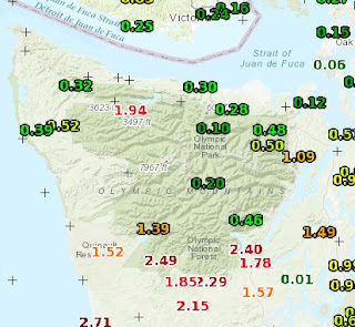
But what about the Olympic Mountains? There is a HUGE difference in precipitation between the southern and northern sides (see blow up). Up to 2.5 inches on the south, but a quarter inch on the NE side. Why? Those southerly winds!
Because the Olympics are a somewhat circular barrier, southerly air is forced to rise on the southern side, producing heavy precipitation. But then it sinks on the northern side, causing warming and drying....and much less precipitation.
So today is a good example of the precipitation distribution for southerly winds.
What if the winds were westerly (from the west)? You might get a precipitation distribution like this (see below), with large amount of precipitation on the western sides of the Olympics and Cascades, and much less over Puget Sound (which is then rain shadowed by the Olympics).
So wind direction is important. And other factors can come into play, like the stability of the air (the tendency to rise when given a little push upwards).
When air has low stability or nearly unstable, a little lift up can cause the air to become buoyant and convect...producing a heavy convective shower or even a thunderstorm. This often happens at the bottom of slopes.
Ever hit very heavy showers near North Bend when driving eastward on I-90. Such an instability shower is probably what was going on. If the air was more stable, the heavier precipitation would be up the slopes somewhere.
Pretty complicated stuff! That is why meteorologists get the big bucks. 😃


Good explanation. Given the southernly flow, wouldnt Paradise, Mt Rainier NP have greatest accumulation or would it be explained away by the turbulence generated by the western slopes of the cascades south of it? Would be curious about the snow amounts at Camp Muir (though the winds would kick most of the snow up and over it).
ReplyDeleteYou can track the snow depths with the NWAC SNOTEL system on Rainier. They are live and showing hourly accumulation/total depth.
DeleteCliff, thanks for the interesting post. Have followed your page for many years and I always learn new things!
ReplyDelete