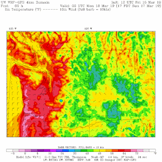
You won't have to --such temperatures will be widespread around western Washington on Monday and Tuesday.
The last day to get above 60 was January 11th (61 was the max). We will smash that number on Sunday.
The latest National Weather Service GEFS multi-forecast ensemble forest for this week shows steadily rising surface air temperatures the next few days, with most predictions getting into the mid-70s.
But those runs are relatively low resolution. Let me show you the higher resolution forecasts done at the UW, and specifically the surface air temperatures at 5 PM each day.
Today? Upper 50s around Puget Sound, warming to the mid-60s near Portland.
This verified well.
Saturday? A step upwards by about 5F. And much cooler over eastern WA.
Sunday afternoon, a few degrees warmer, with particularly warming near the coast, where it will get to around 70F. The reason? Increased offshore flow.
But get yourself prepared for what will happen next. A huge warm-up in virtually all of western WA, with highs jumping into the low 70s.
And even a bit warmer on Tuesday-- I would not be shocked to see some favored locations move into the mid-70s west of the Cascade crest. And really major warming over eastern WA, which should melt a lot of the snow in the Columbia Basin.
This warming is associated with the development of high pressure east of the Cascade crest, offshore flow, and the development of coastal low pressure (the thermal trough)...see figure below. Enjoy.


yay! we are due.
ReplyDeleteNope, nothing to see here folks. No climate change at all.
ReplyDeleteWhere are the 60’s we were sposed to get this week 🧐? Dr cliff has yelled wolf but once to many thymes. Just messin with you. I always remember though when you warned us about a heat wave coming One summer. In the morning I saw the forest fire smoke clouds coming in from the north, we were inundated for two to three months, Never did get the heat wave. We got a snoke wave
ReplyDeleteWell it’s already well below freezing @ 10pm. It will kinda be an inverse of sides because Eastern Washington starts to be warmer than the west side this time of year. So you’ll have Chinook style winds that will melt your lower slopes while we’ll have some cool air damming keeping our snow in place, which is a good thing.
ReplyDeleteI don’t ever recall a time since the start of your blog that we have had a such a consistent pattern of easterly style flow. I mean we really start to get some west winds by now and nada. Because if we did it melts the snow and it warms up fast. Look at our temperatures. We still have a foot of snow on the ground March 15th. It’s rare to see leftover snow patches on March 1st lol.
Remnant1978, I believe that was summer 2017. If we hadn't had the smoke the temperatures would have been higher. It felt wrong to be somewhat grateful for smoke, but I was glad to not quite reach record-breaking highs those particular days. I really hope 2019 isn't a repeat of the last two years, but I did make sure to reserve my camping trips earlier in the summer just in case August gets smoked out again.
ReplyDeleteI have a summer place in the Chilcotin region of BC and I have also made my plans earlier in the summer due to the relentless mid-summer smoke of 2017 and 2018. Although if we get a dry spring it can smoky earlier like in 2015.
DeleteSaturday's sunshine had so many people out and about with their children/pets.
ReplyDeleteIt was fun to take in all of the sights and especially being serenaded by what sounded like a huge number of croaking frogs at Magnuson Park with friends.
The dog park seemed to have record numbers of attendees and some of the owners did resemble their dogs somewhat. Plenty of entertainment is available people watching and walking from the entrance down to the lake where you dog can take a swim (drying off on the walk back).
Good times!
The already too warm Arctic is going to be warming even more - with major implications for global weather and climate
ReplyDeletehttps://www.dailymail.co.uk/sciencetech/article-6814345/Scientists-warn-rising-temperatures-Arctic-locked-in.html
Flopping from record lows to record highs. Sure looks like jet stream instability.
ReplyDelete