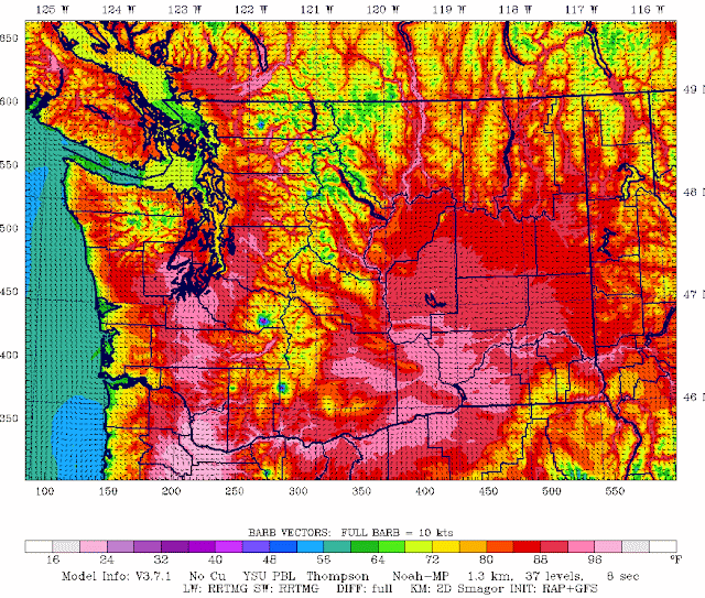
Here is a forecast map of the temperatures at 5 PM on Wednesday. Really toasty in Portland and the Willamette Valley (100F plus) and way up in the 90s from Olympia southward. Want to be cooler? Head to NW Washington, high Cascade terrain, the coast, or the shore of Puget Sound.
But then expect cooling in steps. Marine air will start pushing in on Wednesday night, so Thursday will probably drop 7-9 degrees (see the National Weather Service ensemble forecasts for the next few days). Friday, another decline, with highs in the mid-70s. Just perfect.
The air will be clean tomorrow, with no significant fires around the region--in contradiction to what some scaresters have been saying. Tomorrow will be warm, but there will be no lightning and strong winds are not expected. So if we are careful, there should not be a fire problem.
But winds will pick up later on Thursday over the eastern slopes of the Cascades as cooler air pushes over the crest...so folks will have to be even more atentive then.


Cliff,
ReplyDeleteI always enjoy knowing what to expect and when it will happen!
You're the best.
97 F. in Portland today was a record for the date. The high tomorrow is supposed to beat the old record by 5 degrees!
ReplyDeleteMy garden is hating it.
Maximum temperature in NW Bellingham yesterday was 78.9F. Minimum temperature this morning was 56.4F.
ReplyDeleteWhat has pushed the dew ooints so high during this heat? Flow is out of the north and east which seems unlikely to provide unusual moisture.
ReplyDeleteI think it’s the thunderstorms but I wanna know too.
Delete"Hesitating to fund better climate models makes no sense, neither scientifically nor economically."
ReplyDeleteHappy for the cooling trend the next couple of days, thanks!
ReplyDeleteI'm really hoping high pressure doesn't build back in next week, and the jet stream (and its attendant cirrus) steers clear of WA. We've got a big soaring competition in Central/Eastern WA so I'm keen to see moderate instability and strong insolation over the next 7-10 days!
Max temperature in NW Bellingham today: 82.2F. Max dewpoint temperature: 69F - highest dewpoint temperature I've recorded in nearly 4 years of measurement.
ReplyDeleteI second the question about why the dewpoint has been so high. With easterly flow leading up to this heat spell, I would expect desert air to drop the dewpoint down into the 40s, but yesterday afternoon it touched 60. I must be missing something.
ReplyDeleteMinimum temperature in NW Bellingham this morning: 57.1F.
ReplyDeleteBellingham max was 85F at the airport on 6/12, a record for the date.
ReplyDeleteThe peanut gallery looks forward to reading what the Professor makes of this event: NOAA upgrades the U.S. global weather forecast model
ReplyDelete"Sea-Tac reads warm due to concrete..." Isn't that a constant in the variable? I seem to remember rumblings of people wanting the official measurement of Seattle to be somewhere else due to this. Where would be an ideal location for Seattle? I'm assuming anywhere near the concrete jungle would be no better.
ReplyDelete"Sea-Tac reads warm due to concrete“.
ReplyDeleteThat may be true, but consider this:
-Washington’s Olympic coast has shown the same rate of warming as Puget Sound.
-Since 1950, Grays Harbor County has been warming faster than King County.
-In 1950 the population of Aberdeen, Grays Harbor’s biggest town, was around 19,000. Today it’s around 16,000.
Sources - Climate at a Glance, Wikipedia