The developing El Nino is "swinging for the fences" and will almost certainly be in the "strong" category this winter, with its effects having an enhanced chance of being significant.
An El Nino is considered "strong" when the sea surface temperature difference from normal in the central equatorial Pacific is more than 1.5°C for at least three months in a row.
The observations suggest this is already happening.
The area used to define El Nino (and La Nina) events is the Nino 3.4 zone in the central tropical Pacific (see map below).

The observed sea surface temperature in the Nino 3.4 area (see below) has been at or above 1.5C above normal for three months---and it is not done strengthening.

Now let's turn to the predictions for the next several months from major forecasting systems (see below). Most forecasts predict that El Nino will strengthen this fall and winter, with a good chance of tropical Pacific sea surface temperatures reaching 2°C above normal.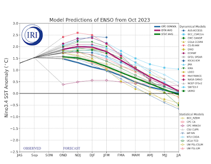 As I have mentioned many times, the correlation of El Nino with our fall weather is weak, consistent with the near-normal autumn so far. But after the new year, El Nino impacts increase and strong El Ninos tend to have greater impact.
For western Washington, January-March tends to be warmer than normal during El Nino years (by about 1°F). Neutral years represent more typical conditions.


So more mountain snow after Jan 1 or less?
ReplyDeleteLess, I think. But last spring was supposed to be wet because of La Nina and it wasn't.
DeleteSince here in Portland all we heard about was the "widespread and serious drought conditions across all of Oregon," suddenly that talk has greatly diminished after the recent deluge of rain. Of course, this panic - mongering will return in even greater force if the typical El Nino latter stages of winter kick in.
ReplyDeleteChris W - with 2" less moisture (avg) " the region is generally drier than normal by about 2 inches" - said Cliff, and and (avg) increase of 1 degree F, "For western Washington, January-March tends to be warmer than normal during El Nino years (by about 1°F)"; would seem to indicate less snow after Jan 1st.
ReplyDeleteThank you for the information; it's fascinating. A one-degree difference temp-wise, and two inches precip-wise ...that's not much of a difference overall. What I've observed so far is very (very) "near normal," long term. As for "ski season," given the early snow (light as it may be) I don't know that anyone should hand-wring at this point, there's no real "basis" to IMHO.
ReplyDeleteHeavy precip is supposed to start on Monday in California. Watch for news articles and attributions to global warming.
ReplyDeleteThe cottonwoods, maples, birches and aspens have really put on a show this season - easily the most vibrant fall colors since 2019.
ReplyDeleteI've been wondering about the especially vibrant colors this fall. It's been a notably (and enjoyably) more colorful season than I remember in past years.
DeleteWe have a big-leaf maple in our back yard, and it looks brilliant right now. I agree with your observation.
DeleteWRT El Nino-related temperature and precipitation anomalies, it would be nice to know exactly what "Climate Div. #075" is. A mean January-March temperature of slightly below 39F (ENSO neutral) is colder than virtually all populated areas of Western Washington and mean January-March precipitation (ENSO neutral) of slightly less than 24" is wetter than virtually all populated areas of Western Washington other than the western Olympic Peninsula. Graphics shown in previous blogs appear to indicate that Western Washington is divided into several different climate divisions which have varying January-March temperature and precipitation anomalies during El Nino.
ReplyDeleteLiving on a steep hill in N Seattle, the less snow and ice, the better.
ReplyDeleteBut last year had a drier than normal early spring- with a La Nina. So hopefully the trend goes counter to experience again, and gives us a good water year. Otherwise... Smogust and Smoketember in 2024.
ReplyDeleteCliff, do these slightly warmer winters make nasty 'arctic air' cold snap events pushed our way from Alaska like the previous two years less likely?
ReplyDelete